Showing 3153 items matching "south west"
-
 Bacchus Marsh & District Historical Society
Map, Gorrockburkchap Parish Map, County of Grant
... Gorrockburkghap) lies to the west and south west of the township... Gorrockburkghap) lies to the west and south west of the township ...The parish of Gorrockburkchap (sometimes spelled Gorrockburkghap) lies to the west and south west of the township of Bacchus Marsh. The locality of Rowsley is situated within this parish area.A single page paper map showing the parish plan for Gorrockburkchap in the County of Grant. The map is pasted into a bound volume containing 76 maps or plans in total. High resolution digital image stored on BMDHS computer network. gorrockburkchap parish maps, rowsley victoria maps -
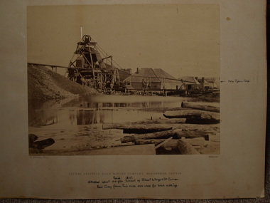 Clunes Museum
Photograph, C. NETTLETON, APPROX. 1865
... THIS MINE WAS SITUATED ABOUT 100 YARDS SOUTH WEST OF ALBERT...THIS MINE WAS SITUATED ABOUT 100 YARDS SOUTH WEST OF ALBERT ...THIS MINE WAS SITUATED ABOUT 100 YARDS SOUTH WEST OF ALBERT STREET AND ANGUS STREET CORNER. RED CLAY FROM THIS MINE WAS USED FOR BRICK MAKING..1 SEPIA PHOTOGRAPH OF CLUNES ALLUVIAL GOLD MINING CO. .2 SEPIA PHOTOGRAPH OF POPPET HEAD-MINERS ON PLATFORM-THATCHED ROOF BUILDINGS, SCATTERING OF LARGE LOGS IN FOREGROUND, USED FOR FIRES. .3 COPY OF ABOVE PHOTOGRAPH IN BLACK AND WHITE (POSTCARD SIZE).1 PRINTED: CLUNES ALLUVIAL GOLD MINING COMPANY REGISTERED CLUNES .2 PRINTED ON FRONT : ALLUVIAL GOLD MINING COMPANY REGISTERED CLUNES HANDWRITTEN: PERIOD 1865. SITUATED ABOUT 100 YDS SW OF ALBERT AND ANGUS STREET CORNER. RED CLAY FROM THIS MINE WAS USED FOR BRICK MAKINGphotographs, mining, clunes alluvial mining company -
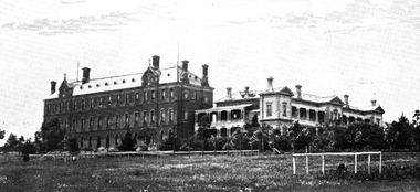
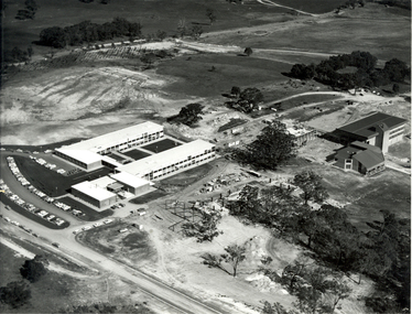 Federation University Historical Collection
Photograph - Black and White, N. L. Harvey, Aerial Views of Mount Helen Campus, 1973, 1973
... construction, Aug 1973 * View to the South West showing Stage 2... 2 buildings under construction, Aug 1973 * View to the South ...The Stage 2 buildings at the Federation University Mount Helen Campus were underway in 1973.Three aerial photographs of the Mount Helen Stage 2 building activities * Westward view of Stage 2 buildings under construction, Aug 1973 * View to the South West showing Stage 2 buildings under construction, Aug 1973 * View to the North West showing Stage 2 buildings under construction, Aug 1973federation university, federation university australia, feduni, university of ballarat, ballarat townscape, mount helen, construction, stage 2 -
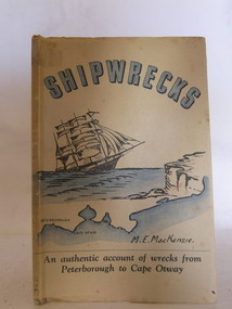 Flagstaff Hill Maritime Museum and Village
Book, Shipwrecks
... sailing ship approaching cliffs, and a map of the coast of south... of the coast of south west Victoria, showing Peterborough and Cape ...Margaret MacKenzie had first hand knowledge of many shipwrecks along Victoria's treacherous 'shipwreck' coast. In her later years her failing sight caused her to attend the nearby eye specialist Dr W.R. Angus in Warrnambool. Dr Angus designed the cover for Margate's book. Margaret's daughter assisted in the writing due to her mother's failing sight.Shipwrecks by M.E. MacKenzie, part of the W.R. Angus Collection. An authentic account of wrecks from Peterborough to Cape Otway, Victoria. Cover printed in blue, black and white, depicts sailing ship approaching cliffs, and a map of the coast of south west Victoria, showing Peterborough and Cape Otway. Art work for cover was done by Dr. W.R. Angusflagstaff hill, warrnambool, shipwrecked-coast, flagstaff-hill, flagstaff-hill-maritime-museum, maritime-museum, shipwreck-coast, flagstaff-hill-maritime-village, shipwrecks, m e mackenzie, peterborough, cape otway, shipwreck coast, book, w.r. angus -
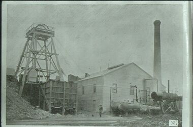 Bendigo Historical Society Inc.
Slide - ALBERT RICHARDSON COLLECTION: HUSTLERS REEF MINE OLD HUSTLERS
... Slide. Hustlers Reef Gold Mine, Old Hustlers, south west..., Old Hustlers, south west corner Anderson Street and Prouses Rd ...Slide. Hustlers Reef Gold Mine, Old Hustlers, south west corner Anderson Street and Prouses Rd. Poppet head on LH side, wooden quartz bins in front. Boilers and compressors outside the engine/boiler room. Man standing centre of image in front of engine room. Photo sourced from 'Healthy Golden Bendigo'No. 32 printed on bottom of slidemine, gold, hustlers reef., bendigo mines-jack hattam collection. -
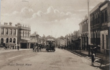 Kew Historical Society Inc
Postcard, Main Street, Kew, c.1890
... ], Kew, looking south west from near its junction with Cotham... Main Street [High Street], Kew, looking south west from near ...The Kew Historical Society's Pictures Collection is comprised of photographs, postcards and original works of art. The postcards include original (mainly) images dating from the 1900s to the present. A number of postcards, some of which have numerous variants, were published as parts of series. Others are original images customised as postcards. Many of the postcards in the collection depict places within the suburbs of Kew and Kew East. Others depict locations in Victoria or internationally. A monochrome postcard showing Main Street [High Street], Kew, looking south west from near its junction with Cotham Road, showing: Ryan’s Council Family Hotel, T. G. Jellis (baker, confectioner), Herbert King (undertaker), L. Merritt (boot warehouse), horse tram, horse drawn vehicles and pedestrians.Post card text addressed to Miss Newell of Balmain.high street - kew, cotham road - kew, tramways - kew -
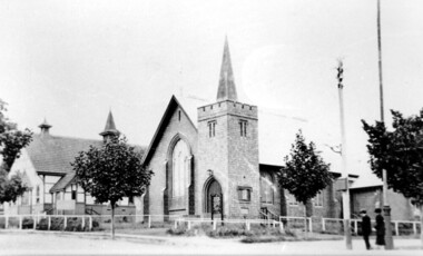 Surrey Hills Historical Society Collection
Photograph, Holy Trinity Church of England, Surrey Hills post 1926, After 1926
... the south-west corner of Guildford Road. Further up the hill... taken from near the south-west corner of Guildford Road. Further ...St George's Church of England, Mont Albert was built in 1886 and from 1904 until 1907 was known as Holy Trinity, Surrey Hills. As the population increased there was a need for a church in Surrey Hills. This brick church was consecrated in 1922 and replaced the earlier one built in 1907 on the adjacent site in Union Road. After construction of the brick church, the earlier one became a Sunday School. The copper spire was added in 1926, which dates this photo as post-1926. Norman Carter took many photos of Surrey Hills and Mont Albert in the 1920s; many were associated with events and activities of the Church of England.Black and white photo of the 'newly' constructed brick Holy Trinity Church in Union Road, Surrey Hills taken from near the south-west corner of Guildford Road. Further up the hill is the earlier church. Both buildings are bounded by a simple post and rail fence. Immature street trees are planted on both sides of Union Road.churches, holy trinity church, anglican church, sunday schools, norman carter -
 Melbourne Tram Museum
Photograph - Block Mounted Photograph, Surrey Hill Neighbourhood Centre, c1920
... in the background the Tea Rooms and notes that they were on the South West... on the South West corner of the intersection. Notes that the image ...Photograph - mounted onto a heavy card, numbered 65-574 in the top right hand corner of MTTB No. 138 at the intersection of Riversdale and Warragul Road intersection Wattle Park. Has in the background the Tea Rooms and notes that they were on the South West corner of the intersection. Notes that the image is courtesy of the TMSV. See image i2 for a scan of the photograph.On rear in ink "Copied for Keith Kings 2002: and the "Surrey Hill Neighbourhood Centre" stamp.trams, tramways, wattle park, riversdale road, tram 138 -
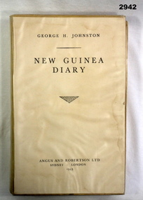 Bendigo Military Museum
Book - BOOK, DIARY, George H Johnson, New Guinea Diary 1943, 1943
... as a war correspondent in the South West Pacific area during WWII... as a war correspondent in the South West Pacific area during WWII ...Text is in diary form covering the Author's time spent as a war correspondent in the South West Pacific area during WWII. Diary dates from 23.1.1942 - 23.1.1943.Book, hard cover with yellow buckram. Title & Author's name in black lettering. Title page has been removed from book & glued to front cover. Book is covered in clear plastic. Black & white photographic illustrations, 260 pages with cut edges.On 1st page in pencil: “3/6”books, new guinea, 1943 -
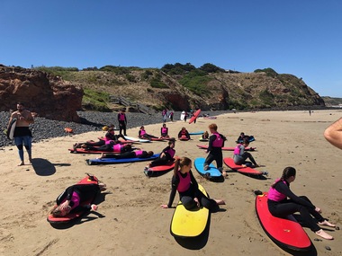 Galen Catholic College
Anglesea Year 8 Camp, 2019
... camp at Anglesea to the south west of Geelong. One... attended a school camp at Anglesea to the south west of Geelong ...For many years now, Year 8 students have attended a school camp at Anglesea to the south west of Geelong. One of the activities that the students experienced was learning to surf.galen catholic college, galen college, surf, surfing, camp, camp activitiy, 2019 -
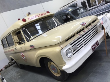 Ambulance Victoria Museum
Vehicle, motor, Ambulance, Ford F100, 1963, 1963
... F100 was used exclusively in the South West region of Victoria... F100 was used exclusively in the South West region of Victoria ...Built for the Glenelg Regional Ambulance Service. The Ford F100 was used exclusively in the South West region of Victoria. This vehicle is typical of ambulances built for Australian rural areas.Four-wheeled motor vehicle fitted out as an ambulance. Bodywork painted dark cream colour. Radiator surround and bumper painted white.Registration number 15171H Has the word 'Ambulance " written above the front windscreen and ................ADD MOREambulance, motor vehicle, ford, ford f100, glenelg -
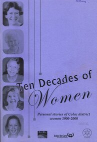 Otway Districts Historical Society
Book, Colac Herald Press, Ten Decades of Women, 2005
... in south-west Victoria, Australia.... from the Colac region in south-west Victoria, Australia. colac ...A Women's History Month 2005 project recording the stories of 'ordinary' women born between 1900-2000 from the Colac region in south-west Victoria, Australia.Ten decades of women. Personal stories of Colac district women 1900-2000. Margaret Evans. Merrill O'Donnell. Kerri Bauer. 1st ed. Colac (Vic); Colac Herald; 2005. iv, 100 p.; illus. Soft cover.colac district; women; -
 Yarra Ranges Regional Museum
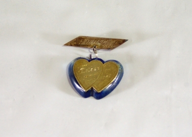
Brooch, 1944 - 45
... in the South West Pacific during WWII. The resin for the brooch came... Ron Fraser when he was serving in the South West Pacific ...Sent to his mother from Ron Fraser when he was serving in the South West Pacific during WWII. The resin for the brooch came from the windsheid off his areoplane.Silver or silver-plated brooch, oblong with pin on back on a scroll shaped link attached. The bottom part is a silver double heart shape stuck onto a blue resin backing, also double heart shaped.Etched on top part: SW Pacific / 1944 - 5 Etched on the bottom part: To/ Mother/ with SWP/ Love 1945world war 2, costume accessories, jewellery -
 Ringwood and District Historical Society
Photograph, South-western view from Marcel Street North Ringwood over Jull Parade to Oban Road - 1981. North Ringwood Sports Reserve is on the left, above the corner of Jull and Oban Roads
... . Looking south-west from Marcel Street North Ringwood over Jull... reads, "E620. N1. 1981. Looking south-west from Marcel Street ...Writing on back of photograph reads, "E620. N1. 1981. Looking south-west from Marcel Street North Ringwood over Jull Road to Oban Road. North Ringwood Sports Reserve centre left above corner of Jull and Oban Roads". -
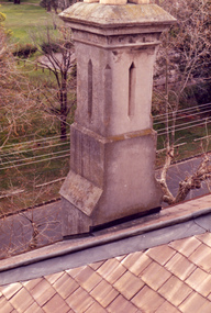 Villa Alba Museum
Photograph - Rendered chimney, c.1987
... of one chimney on the south west corner of the house... on the south west corner of the house. The distinctive rendering ...Built for William and Anna-Maria Greenlaw in the early 1880s, and with interiors decorated by the Paterson Bros, Villa Alba remained in private ownership until 1949. From 1950, the house was owned by a number of institutions. By 1984, the Villa Alba Preservation Society had been formed, and three years later, the Mount Royal Hospital granted a 25-year lease to Kew Council. In 2004, the title to Villa Alba was passed by the Victorian Government to The Villa Alba Museum Incorporated. The Museum, at 44 Walmer Street, Kew, is now a cultural institution committed to the collection, study and display of 19th century interior decorative finishes, and the components of 19th and 20th century interior decoration.This is one of a number of historically and aesthetically significant photos of the interiors and exterior of Villa Alba when it was still owned by the Mount Royal Hospital, showing twentieth century accretions and deterioration of the historic fabric of the building. This was a benchmark survey against which future conservation and restoration activities can be measured.In December 1987, Mockridge Stahle & Mitchell Pty Ltd Architects prepared ‘Villa Alba Survey: A Report on the fabric for Mount Royal Hospital’ of which this photograph is a part. Photo of one chimney on the south west corner of the house. The distinctive rendering of the chimney cornets with the welsh slates used on the roof. This chimney services the fireplaces in the dining room and the second and third bedrooms. villa alba museum, conservation photographs, victorian architecture, slate roofs, chimneys -
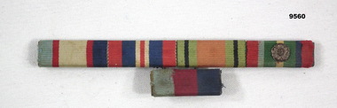 Bendigo Military Museum
Award - SERVICE RIBBONS, WW2
... in order: 1939-45 Star, South West Pacific Star with Burma rosette...-45 Star, South West Pacific Star with Burma rosette, Defence ...Service ribbons belonging to VX61585, "Pte L.A. Murray/McCormack", 22 Aust Brigade WKSP. Part of the Cooper Collection.Bar with five WW2 service ribbons. Bar with 1939-45 Star attached to the top of the bar with the remaining four. Ribbons in order: 1939-45 Star, South West Pacific Star with Burma rosette, Defence Medal 1939-45, War Medal 1939-45, Australian Service Medal 1939-45. Ribbons backed with brass plate and pin.cooper collection, service ribbons, ww2, l.a. mccormack -
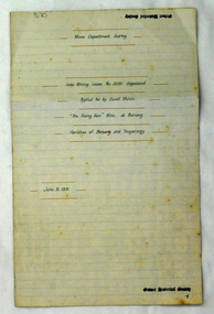 Orbost & District Historical Society
plans, June 15 1931
... .– at Goongerah Creek south west of Bonang. William Hunter (1893-1971....– at Goongerah Creek south west of Bonang. William Hunter (1893-1971 ...The Rising Sun Reef first opened, at Bonang in 1868.– at Goongerah Creek south west of Bonang. William Hunter (1893-1971), resident of Tatura and Mallacoota was a soldier, surveyor and amateur naturalist. This document is a useful research tool.Plans and application for the "Rising Sun Goldmine". Tery are on foolscap sized white paper with black text. hunter-william gold-mining rising-sun-goldmine bonang -
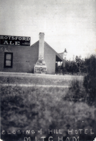 Whitehorse Historical Society Inc.
Photograph, Hill Hotel, Mitcham
... was situated on the south-west corner of Station Street and Whitehorse... was situated on the south-west corner of Station Street and Whitehorse ...The Hill Hotel was one of 3 hotels in Mitcham in the 1890's.The licensee was Mrs Bridget O'Callaghan. The hotel was situated on the south-west corner of Station Street and Whitehorse Road. It was delicensed in 1919Black and white photograph of the Hill Hotel, Mitcham, after it had closed in 1919. Graffiti on chimney.|See also NP1329. Alternative name - O'Callaghan's Hotelhill hotel, o'callaghan's hotel, hotels -
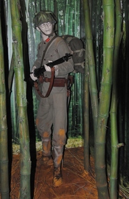 Australian Army Museum of Western Australia
Diorama, 2015
... Gallery - South West Pacific area. A private soldier is shown... is the introductory feature in the World War 2 Gallery - South West Pacific ...This diorama is the introductory feature in the World War 2 Gallery - South West Pacific area. A private soldier is shown cautiously advancing down a jungle track outflanking Allied defensive positions1:1 scale diorama showing soldier of Imperial Japanese Army advancing through jungle in Malaya January 1942fall of singapore, 8th australian division -
 St Patrick's Old Collegians Association (SPOCA)
Photograph - Buildings, Xavier College, 1901
... Xavier College, west & south wings in 1901, looking from... melbourne Xavier College, west & south wings in 1901, looking from ... -
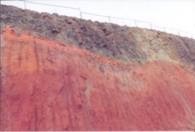 Kilmore Historical Society
Photograph, 91 Sydney Street, July 2016
... : Exposed volcanic rock look south west 91 Sydney St Kilmore late... rock look south west 91 Sydney St Kilmore late July 2016 15cm x ...15cm x 10cm coloured photograph of the cutting at 91 Sydney Street, Melbourne Street at the top of the cutting which exposed the volcanic rock. Now is the site of the car wash and KFC.written on the back of .1: cutting @ 91 Sydney St Kilmore Melbourne St 2 top of cutting late July 2016 Written on the back .2: Exposed volcanic rock look south west 91 Sydney St Kilmore late July 2016construction -
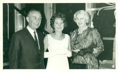 Warrnambool and District Historical Society Inc.
Photograph - Vedmore family, c 1950s
... disadvantaged families in South West Victoria. ... in South West Victoria. This item is retained because ...This is a digital copy of a photograph of Cecil, Gladys and Susan Vedmore on the occasion of Susan's debut. The Vedmore family set up the Vedmore Trust to provide funds for financially disadvantaged families in South West Victoria. This item is retained because of the Vedmore family's association with a local trust.This is a digital copy of a black and white photograph of a father in a suit and tie, his daughter in her debutante frock and her mother dressed in formal wear.vedmore trust, cecil vedmore, gladys vedmore, susan vedmore -
 Federation University Historical Collection
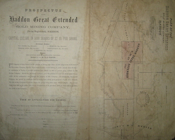
Plan and Prospectus, Plan and Prospectus of the Haddon Great Extended Gold Mining Company
... to the south-west of the Racecourse Company (who at that stage had... for the purpose of mining 270 acres of land lying to the south-west ...The Haddon Great Extended GMC was formed sometime in the 1870s for the purpose of mining 270 acres of land lying to the south-west of the Racecourse Company (who at that stage had a shaft at the depth of 86 feet)A printed piece of paper with a prospectus on the left and a plan on the right. The plan includes a shaded area representing the Haddon Great GMC, and shows neighbouring companies such as Racecourse GMC, Haddon Consols, Reform GMC, Haddon Co, and also shows Russel's Private Propert and Roach's Private Company, and the Trap-Rock Formation.haddon great extended gmc, wc elder, william levey, c thorburn, john langdon, hb forster, national bank of australasia, haddon, racecourse company, h.b. forster, w.c. elder, john langdon, william levey, c. thorburn, john langdon, shares, racecourse goldmining company, reform gold mining company, haddon consols, haddon great extended gold mining company, russell -
 Otway Districts Historical Society
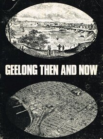
Book, Lothian Publishing Co. Pty. Ltd, Geelong - Then and Now, 1969
... km. south west of Melbourne on the curve of Port Phillip Bay... of Victoria, lies some 72 km. south west of Melbourne on the curve ...Geelong, second city of the state of Victoria, lies some 72 km. south west of Melbourne on the curve of Port Phillip Bay. This short history covers from the aborigines through to the mid-1960. Geelong - Then and Now. C.P. Billot. 1st ed. Melbourne (Vic)203mm x ; Lothian Publishing Co. Pty. Ltd.; 1969. iv, 44p.; illus., map. SBN 85091 109 5geelong; history; aborigines; corio shire; -
 Linton and District Historical Society Inc
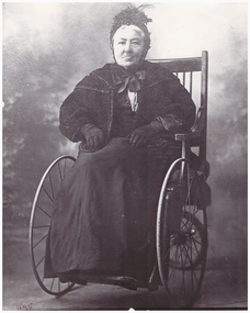
Photograph, Mrs. Henry Francis
... , and they had nine children. In the 1870s they acquired land south-west..., and they had nine children. In the 1870s they acquired land south-west ...Mary Hepbuirn (or Hepburn) married Henry Francis in 1857, and they had nine children. In the 1870s they acquired land south-west of Linton, where they lived and farmed for many years. They called their property "Newland".Black and white copy of original photograph of an older lady seated in a wheelchair, dressed in black, featuring a fancy cap.mrs henry francis (née mary hepbuirn or hepburn) -
 Bendigo Historical Society Inc.
Map - CAMPBELL COLLECTION: BENDIGO AND DISTRICT MAPS
... south west on map, also on page is the Northern Railway (Bendigo... and road to Bendigo 4 1/2 miles south west on map, also on page ...Map. Ascot Unit, scale 20 chains to an inch, arrow pointing to magnetic north, road to Fosterville to the East, Huntly 3/4 mile to the West, road to Epsom 3/4 mile and road to Bendigo 4 1/2 miles south west on map, also on page is the Northern Railway (Bendigo to Echuca) line. (number 355 in map cupboard 1)map, bendigo, country lands -
 Bendigo Historical Society Inc.
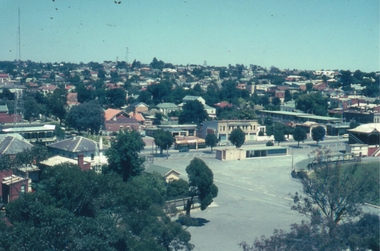
Photograph - ROY J MITCHELL COLLECTION: VIEW FROM LOOKOUT TOWER, QUEEN ELIZABETH OVAL, BENDIGO
... Oval, Bendigo, looking south west. View Street centre field..., looking south west. View Street centre field, QEO carpark and Art ...Colour photograph taken from lookout tower, Queen Elizabeth Oval, Bendigo, looking south west. View Street centre field, QEO carpark and Art Gallery buildings in foreground. Written on back of photo ' Jan 1972, Bendigo from Lookout Tower, Pall Mall (not accurate, should be View Street) towards Golden Square, by Roy J Mitchell'Roy J Mitchellbendigo, streetscape, queen elizabeth oval -
 Orbost & District Historical Society
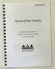
book, Spirit of the Snowy, 2002
... of the Mountain. Graeme Enders is Manager South West regional operations... of the Mountain. Graeme Enders is Manager South West regional operations ...This book was compiled to mark a three day journey along the Snowy River in 2002. It was part of the International Year of the Mountain. Graeme Enders is Manager South West regional operations at N.S.W. Office of Environment & Heritage.A spiral bound book with a plastic cover. It is titled Spirit of the Snowy and is a collection of short stories written to mark a Snowy River journey from 1st to 3rd November in 2002. The book was edited by Graeme Enders of the Snowy River Recovery Project and published by the New South Wales Premier's Dept. It contains poetry, stories and recollections.2002 International Year of Mountainssnowy-river -
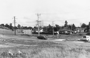
 Greensborough Historical Society
Photograph, Grimshaw Street Greensborough, 1976c
... South-west corner of Grimshaw and Henry Streets, showing... Plenty Lower Plenty melbourne South-west corner of Grimshaw ...South-west corner of Grimshaw and Henry Streets, showing Safeway (Woolworths), traffic lights and BP service station. Greensborough first traffic lights were installed along Grimshaw Street circa 1976.Black and white photograph"Safeway opposite the Greensborough Primary School, traffic lights for school crossing"safeway, grimshaw street greensborough, henry street greensborough -
 Flagstaff Hill Maritime Museum and Village
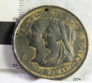
Medal - Commemorative medal, 1897
... This coin was found in the ground at Glenormiston, South... at Glenormiston, South West Victoria, in 1940. The medal was commissioned ...This coin was found in the ground at Glenormiston, South West Victoria, in 1940. The medal was commissioned by Mayor W. J. Hickford and issued by the Town of Warrnambool in 1897 to commemorate the 60th jubilee of the reign of H.M. Queen Victoria. The medal is significant for recognising the 60th year of reign of Queen Victoria, after whom our State of Victoria was named. It also has significance in showing the early design of the City of Warrnambool's Coat of Arms, which includes the British Coat of Arms. Commemorative medal, HM Queen Victoria's Jubilee, issued by the Town of Warrnambool in 1897. A round, gilt metal disc with plain edges and a drilled hole in the top. The Obverse shows the Queen's profile, young and old, The Reverse has Warrnambool Town's coat of arms including a sailing ship, a sheave of wheat and a rising sun, with a motto below them. The medal has stamped inscriptions.Obverse "QUEEN VICTORIA'S 60TH YEAR OF REIGN" / 1837 TO 1897". Reverse " TOWN OF WARRNAMBOOL / W J HICKFORD MAYOR" and the motto "BY THESE WE FLOURISH"flagstaff hill, flagstaff hill maritime museum and village, warrnambool, maritime museum, maritime village, great ocean road, shipwreck coast, medal, medallion, numismatics, commemorative medal, jubilee medal, queen victoria, queen victoria’s 60th jubilee, 1837-1897, town of warrnambool, 60th jubilee, young queen victoria, older queen victoria, warrnambool coat of arms, warrnambool symbols, warrnambool mayor, mayor hickford, ad 1837-1897, 50 years reign, glenormiston, w j hickford, by these we flourish, city crest, city coat of arms