Showing 1378 items matching "state library victoria"
-
 Eltham District Historical Society Inc
Photograph, Liz Pidgeon, Heritage Excursion; The 1901 Eltham Railway Walk, 3 May 2014, 3 May 2014
... . Copies of these plans from the State Library of Victoria.... Copies of these plans from the State Library of Victoria ...Newsletter No. 216, May 2014 May Excursion – The 1901 Eltham Railway Walk The railway from Heidelberg to Eltham was opened in 1902. Over the previous year railway construction cut a curving swathe through Josiah Holloway’s 1851 Little Eltham subdivision. The survey plans for the railway show the owners and occupiers of land within Little Eltham affected by the railway alignment and for some distance each side. The plans show houses and other buildings but development at that time was rather sparse. Copies of these plans from the State Library of Victoria collection have been provided to the Society by Alan Sheehan. For our walk on 3rd May we intend to follow the railway from the Eltham Station to Ryans Road, which was the boundary of the adjoining Montmorency Farm. The return will be by way of nearby streets. Along the way we will discuss the details shown on the railway plans as well as more recent railway documents and photographs. At the conclusion and if time permits we can inspect the historical display at the Eltham Station. The walk is about 3 km in length and will take about 2.5 hours. It will start at 2 pm at the Eltham Railway Station car park (east/Main Road side) (Melway Ref. 21 J5).Born Digitalheritage excursion, activities, eltham district historical society, eltham railway station, eltham library, trestle bridge -
 Eltham District Historical Society Inc
Negative - Photograph, Carl Walter 1831-1907, Coffer dam in the Yarra River at Anderson's Creek, 1864
... . Walter Photo” The State Library of Victoria holds over 150 photos.... Walter Photo” The State Library of Victoria holds over 150 photos ...1864 photograph of the Coffer Dam in the River Yarra situated (approximately) opposite Whipstick Gully. Remains of bridge built in 1860(?) wrecked by 1863 flood in background. Reproduced page 29 of ‘Pioneers & Painters’ Gold was first discovered in this area at Andersons Creek (Warrandyte) in June 1851 by Louis Michel. Discoveries north of the Yarra did not occur until about 1854. Although it took some months for a true rush to develop it was not long before alluvial workings were being carried on in most of the Shire of Eltham. The last area in which gold was discovered was Kinglake. As the gold became harder to find, deep mining took over from alluvial diggings in the gullies. Perhaps the most extensive of the deep workings was the Diamond Creek Mine just outside the boundary of the Shire. This form of mining was continued into the 1930s. There are believed to be some mines in the area still capable of producing gold but present prices make working these uneconomical. Some gold is still found by weekend prospectors. Photo: Carl Walter 1831-1907 – inscribed on tent “C. Walter Photo” The State Library of Victoria holds over 150 photos by Carl Walter, most of which are portraits of Aboriginal natives including William Barak.This photo forms part of a collection of photographs gathered by the Shire of Eltham for their centenary project book,"Pioneers and Painters: 100 years of the Shire of Eltham" by Alan Marshall (1971). The collection of over 500 images is held in partnership between Eltham District Historical Society and Yarra Plenty Regional Library (Eltham Library) and is now formally known as 'The Shire of Eltham Pioneers Photograph Collection.' It is significant in being the first community sourced collection representing the places and people of the Shire's first one hundred years.Digital image 4 x 5 inch B&W Neg (2) Print 20 x 25 cmshire of eltham pioneers photograph collection, anderson's creek, coffer dam, floods, gold mining, other areas, pioneers and painters, warrandyte, warrandyte bridge, yarra river -
 Eltham District Historical Society Inc
Photograph, Liz Pidgeon, Heritage Excursion; The 1901 Eltham Railway Walk, 3 May 2014, 3 May 2014
... . Copies of these plans from the State Library of Victoria.... Copies of these plans from the State Library of Victoria ...Football match at Eltham Central Park between Eltham and Heidelberg Newsletter No. 216, May 2014 May Excursion – The 1901 Eltham Railway Walk The railway from Heidelberg to Eltham was opened in 1902. Over the previous year railway construction cut a curving swathe through Josiah Holloway’s 1851 Little Eltham subdivision. The survey plans for the railway show the owners and occupiers of land within Little Eltham affected by the railway alignment and for some distance each side. The plans show houses and other buildings but development at that time was rather sparse. Copies of these plans from the State Library of Victoria collection have been provided to the Society by Alan Sheehan. For our walk on 3rd May we intend to follow the railway from the Eltham Station to Ryans Road, which was the boundary of the adjoining Montmorency Farm. The return will be by way of nearby streets. Along the way we will discuss the details shown on the railway plans as well as more recent railway documents and photographs. At the conclusion and if time permits we can inspect the historical display at the Eltham Station. The walk is about 3 km in length and will take about 2.5 hours. It will start at 2 pm at the Eltham Railway Station car park (east/Main Road side) (Melway Ref. 21 J5).Born Digitalheritage excursion, activities, eltham district historical society, eltham railway station, eltham library, trestle bridge, eltham central park, football -
 Eltham District Historical Society Inc
Photograph, Liz Pidgeon, Heritage Excursion; The 1901 Eltham Railway Walk, 3 May 2014, 3 May 2014
... . Copies of these plans from the State Library of Victoria.... Copies of these plans from the State Library of Victoria ...EDHS Member Doug Orford stands by a yarn bombing installation. ewsletter No. 216, May 2014 May Excursion – The 1901 Eltham Railway Walk The railway from Heidelberg to Eltham was opened in 1902. Over the previous year railway construction cut a curving swathe through Josiah Holloway’s 1851 Little Eltham subdivision. The survey plans for the railway show the owners and occupiers of land within Little Eltham affected by the railway alignment and for some distance each side. The plans show houses and other buildings but development at that time was rather sparse. Copies of these plans from the State Library of Victoria collection have been provided to the Society by Alan Sheehan. For our walk on 3rd May we intend to follow the railway from the Eltham Station to Ryans Road, which was the boundary of the adjoining Montmorency Farm. The return will be by way of nearby streets. Along the way we will discuss the details shown on the railway plans as well as more recent railway documents and photographs. At the conclusion and if time permits we can inspect the historical display at the Eltham Station. The walk is about 3 km in length and will take about 2.5 hours. It will start at 2 pm at the Eltham Railway Station car park (east/Main Road side) (Melway Ref. 21 J5).Born Digitalheritage excursion, activities, eltham district historical society, eltham railway station, eltham library, trestle bridge, yarn bombing, doug orford -
 Westbourne Grammar Heritage Collection
Book - Charles Steedman, 1867, Manual of Swimming
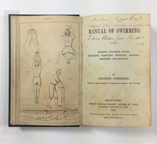
... at the State Library of Victoria), added swimming lessons... can be accessed at the State Library of Victoria), added ...Charles Steedman was headmaster of Williamstown Grammar School from 1870-76 and 1885-90. In 1870, under agreement with school trustees, Sir George Verdon and John Courtis, he leased the school under a seven-year lease, effectively saving it from closure. Steedman had previously been manager of Sandridge Baths and a champion swimmer of Victoria. His 1867 book, 'Manual of Swimming', was the first major technical contribution to the sport of speed swimming and water safety, for which Steedman was inducted into the Sport Australia Hall of Fame in 2006. As headmaster of Williamstown Grammar, Steedman initiated a student produced school paper called 'The Schoolboy' (surviving editions can be accessed at the State Library of Victoria), added swimming lessons to the curriculum and opened enrolment to girls in 1885. The book contains nine illustration plates featuring line drawings of a human figure in the positions detailed by Steedman in his text. These drawings are attributed to O.R. Campbell. Oswald Rose Campbell is best known for his appointment (1876-1886) as drawing master of the School of Design, a department of the Public Library, Museums and National Gallery of Victoria. He taught (and famously disagreed with) the likes of celebrated Australian artists, Tom Roberts and Frederick McCubbin. O.R Campbell taught drawing and painting at Williamstown Grammar in the early 1870s.The book holds historic significance for Westbourne Grammar School, having been written by a former headmaster and very important figure in the history of the school. It evokes our early history as an emerging grammar school with links to prominent athletes, artists and gentry of colonial Melbourne. Blue cloth covered case-bound book, with debossed decorative scrollwork in each corner and in the centre of front cover, and gilt lettering on the spine. 270 numbered pages, nine illustration plates (one adjacent to title page, eight as end pages).On title page, handwritten inscriptions in brown coloured ink. Possibly ‘Joshua Saggs Esq. / With the authors compliments’ and below, in different handwriting and darker ink, ‘To dear Flossie from Grandma 1901’. williamstown, sandridge baths, swimming, colonial melbourne, art, williamstown grammar -
 Victorian Aboriginal Corporation for Languages
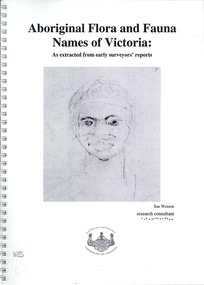
Book, Sue Wesson et al, Aboriginal flora and fauna names of Victoria : as extracted from early surveyors' reports, 2001
... (NRE), the State Library of Victoria, the Victorian Public... and Environment (NRE), the State Library of Victoria, the Victorian Public ...The Flora and Fauna Names Project is an initiative of the Victorian Aboriginal Corporation for Languages and the Victorian Biodiversity Strategy. The researcher has examined material from the archives of the Department of Natural Resources and Environment (NRE), the State Library of Victoria, the Victorian Public Records Office and the Australian Archives Office. This first stage of the project focussed on the NRE archives, in particular the field notebooks of the earliest surveyors and their maps although other NRE resources, libraries and public records were accessed. A total of 3028 words were found of which a significant proportion have previously been unknown to linguists. It appears that the place names and word lists in early surveyors notebooks, the 1858 surveyors responses to the Surveyor General and an extensive Wiradjuri wordlist by James Baylis have not yet been widely used or published. Fifteen percent of these 3028 words describe flora and fauna and six percent describe habitat. Of particular interest is the evidence provided by these lists of the existence of fauna in the mid nineteenth century in regions where it is now extinct. For example, magpie geese, eastern quolls, bustards and pademelons were assigned names in the Jardwadjali language area of the upper Glenelg and Wimmera Rivers. The outcomes of this project may help to assist in ascertaining the distribution of flora and fauna assets in Victoria.maps, b&w photographs, colour photographs, illustrations, word listswiradjuri, jardwadjali, glenelg river, wimmera river -
![Photograph - Photograph, Black and white, Peckham Photographic Studios, Geo Beachcroft, Hanging on up aloft [the] C.B. Pedersen, c. 1935](/media/collectors/4f729f5897f83e0308601603/items/4f72bbce97f83e03086061e1/item-media/581a839ad0cdd11ed4ac0ec3/item-fit-380x285.jpg) Mission to Seafarers Victoria
Mission to Seafarers VictoriaPhotograph - Photograph, Black and white, Peckham Photographic Studios, Geo Beachcroft, Hanging on up aloft [the] C.B. Pedersen, c. 1935
... by the same studio are held at the State Library of Victoria.... by the same studio are held at the State Library of Victoria. Training ...Snapshot in time of tall ship and the relaxed clambering about the rigging by sailors. The C.B. Pedersen is also referred to as a Training Ship for Swedish seamen and cadets. A reference in Annual reports and in Jottings from our log notes that classes in Swedish amongst other languages were offered by the LHLG to members and some of the earliest photographs note Swedish sailors relaxing. The first officer and captain of the C.B. Pedersen are depicted in photograph (0706) on permanent display. In the Sydney Morning Herald, Tuesday 27 April 1937, page 12: "The C. B. Pedersen was built in 1891. It has visited Australia several times, the most recent occasion having been in 1935, when It was anchored in Port Phillip Bay, Victoria, for several weeks, awaiting a suitable cargo. At length the master, (Captain Hjalmar Dahlström) announced that, as no cargo could be obtained he would be prepared to carry passengers in a voyage to Gothenburg, via Torres Strait. Eight persons, including three women and a small boy were accepted as passengers, and signed on as members of the crew at salaries of 1/ a month". Artist Violet Teague was one of the passengers. She painted during the voyage and exhibited her work in 1938. Built in 1891 the C.B Pedersen, a four-masted steel barque (2142 tons) was used as a training Barque. The ship foundered in April 1937, the crew was saved. Several other photographs of the C.B. Pedersen taken by the same studio are held at the State Library of Victoria.Training of seamen has always been of of keen interest to the Mission to Seamen and many cadets have been welcomed over the 20th Century when widespread training was undertaken by a number of seafaring nations. Black and white photograph of 9 men hanging from ropes in the rigging. One man is upside down, another is holding his hat out. The mast is off to the right-hand side of the photograph and there are several ropes and chains.On the back of the photograph in the top left-hand corner is an ink stamp with the text "Peckham Photographic Studios/Geo Beachcroft/Propr./21 Charlotte St./Richmond/Victoria, Australia". In black pen is the text "Hanging on up aloft/C.B.Pedersen".richmond, chains, rope, seafarers, rigging, peckham photographic studios, geo beachcroft propr, cb pedersen, tall ships, captain hjalmar dahlström, windjammer -
 Federation University Art Collection
Artwork, other - Handcut & Collaged maps on paper, 'Survey Vessel I' by Carole Wilson, 2008
... Gallery of Australia, the Powerhouse Museum, State Library..., the Powerhouse Museum, State Library of Victoria and a number of regional ...Carole WILSON (1960- ) Born Canberra, Australia Carole Wilson undertook undergraduate studies at the Canberra School of Arts and Phillip Institute of Technology. She completed a Graduate Diploma in Education at the University of Ballarat in 1987, and a Doctor of Philosophy in 2000. She has chosen central motifs in her work, which she incorporates throughout a series. The urn has been a unifying motif in Wilson's map work and testifies to the way in which function drives form across cultures. Carole's work is held in many public collections including the National Gallery of Australia, the Powerhouse Museum, State Library of Victoria and a number of regional Victorian galleries. Her posters are in museum collections in Finland, Moscow and Poland. In 2001 Dr Wilson was awarded a Doctor of Philosophy (Visual Art) from the University of Ballarat (Now Federation University). She graduated with a Graduate Diploma in Education from University of Ballarat in 1987, and a Diploma of Art from the Phillip Institute of Technology (RMIT) in 1984. Carole Wilson lectures at Federation University Australia: 2010- Senior Lecturer in Visual Arts, Honours and Research Degrees Co-ordinator 2009-2011 Lecturer in Studio Practice and Postgraduate Co-ordinator 1999-2008 Lecturer in Visual Arts (Sessional) This item is part of the Federation University Art Collection. The Art Collection features over 2000 works and was listed as a 'Ballarat Treasure' in 2007. Donated through the Australian Government's Cultural Gifts Program by Anne M. Drum, 2011art, artwork, carole wilson, maps, urn, alumni, available, staffmember -
 Federation University Art Collection
Print, 'Collagraph 3' by Carole Wilson, 2007
... Gallery of Australia, the Powerhouse Museum, State Library..., the Powerhouse Museum, State Library of Victoria and a number of regional ...Carole WILSON (1960- ) Born Canberra, Australia Carole Wilson undertook undergraduate studies at the Canberra School of Arts and Phillip Institute of Technology. She completed a Graduate Diploma in Education at the University of Ballarat in 1987, and a Doctor of Philosophy in 2000. She has chosen central motifs in her work, which she incorporates throughout a series. The urn has been a unifying motif in Wilson's map work and testifies to the way in which function drives form across cultures. Carole's work is held in many public collections including the National Gallery of Australia, the Powerhouse Museum, State Library of Victoria and a number of regional Victorian galleries. Her posters are in museum collections in Finland, Moscow and Poland. In 2001 Dr Wilson was awarded a Doctor of Philosophy (Visual Art) from the University of Ballarat (Now Federation University). She graduated with a Graduate Diploma in Education from University of Ballarat in 1987, and a Diploma of Art from the Phillip Institute of Technology (RMIT) in 1984. Carole Wilson lectures at Federation University Australia: 2010- Senior Lecturer in Visual Arts, Honours and Research Degrees Co-ordinator 2009-2011 Lecturer in Studio Practice and Postgraduate Co-ordinator 1999-2008 Lecturer in Visual Arts (Sessional) This item is part of the Federation University Art Collection. The Art Collection features over 2000 works and was listed as a 'Ballarat Treasure' in 2007. Carole Wilson lectures at Federation University Australia: Framed collograph by Carole Wilson. art, artwork, wilson, carole wilson, available -
 Surrey Hills Historical Society Collection
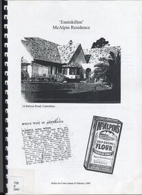
Book, Robin Da Costa-Adams, Enniskillen McAlpin Residence, Feb-09
... is featured on the State Library of Victoria Collection. Robin da... of his work is featured on the State Library of Victoria ...This report was prepared by historian Robin da Costa-Adams to assess the cultural heritage significance of "Enniskillen" at 14 Balwyn Road, Canterbury. It includes some family history on a number of prominent families - the McAlpin family, the Hindson family and the architect, Arthur William Plaisted who designed 'Enniskillen' for the McAlpin family. McAlpin's was a major Victorian flour company in the nineteenth and early twentieth centuries. Owned and operated by J. McAlpin and Sons, the company sold its flour products across Australia and overseas. McAlpin's developed a successful marketing campaign which was pitched directly at housewives. One innovation was the publishing of a free cookbook which had recipes in it that used McAlpin's products. These free cookbooks were published successively from the 1930s through to the 1960s in Australia. Arthur Plaisted also designed the Surrey Hills Medical Centre in Union Road c1911. Some of his work is featured on the State Library of Victoria Collection. Robin da Costa-Adams has researched and written many publications including 'Blackburn a picturesque history, 1978'; 'Land of Gold: Gwlad yr Aur: James Tipping and a Mining Heritage'; 'Address (with signatories) from the women of Ballarat & Ballarat East to the women of England 1864 : against transportation of convicts', compiled and indexed by Robin; and 'Connie's Story : commemorating the Life of Mrs Edward (Plorn) Dickens'. Robin has been a tireless campaigner for heritage protection in Canterbury. This document on 'Enniskillen' was included with Robin's submission for 2 VCAT hearings regarding possible development of the property. Both resulted in a judgement against the proposed developments. In the recent (2021) hearing the document was specifically mentioned in the judgement.A report prepared by Robin da Costa-Adams in 2009 to assess the cultural heritage significance of "Enniskillen" at 14 Balwyn Road, Canterbury. It includes some family history on the McAlpin family, the Hindson family and the architect Arthur WIlliam Plaisted family.(mr) arthur plaisted, (mr) walter plaisted, enniskillen, shrublands, house names, (mr) francis henty, (mrs) mary henty, (mr) ernest carter, heathfield, (mr) john hindson, (mrs) alice hindson, (mr) william hindson, (mrs) annie west mcalpin, (mr) john mcalpin, mcalpin bakery, (mr) keith matthies, dental surgeon, (mr) william wolf, architects, (miss) mary beacon, robin ca costa-adams -
 Glen Eira Historical Society
Document - NEWSPAPER PUBLISHED OR CIRCULATED IN CAULFIELD
... Library of Victoria, both undated and author unknown. The first... at the State Library of Victoria, both undated and author unknown ...This file contains four items: 1/Two typed lists of the names and years of circulation of Elsternwick and Caulfield Newspapers held at the Caulfield Library, the first with amendments in ballpoint pen and the second a revised version of the first dated 12/07/1988. Also included in the item is a typed list of what appears to be issues of the Southern Cross newspaper held at the library and an original handwritten list with a black and white photocopy of newspapers held at the Caulfield Library, dated 11/09/1988. These were provided by Gladys Vallati (longtime member; Head Librarian of Caulfield Library for many years). 2/Two extracts from the Caulfield Historical Society Newsletters (issues April 1975 No 15 and June 1975 No 16) detailing newspapers published and or circulated in Caulfield that are held at the State Library of Victoria, both undated and author unknown. The first has some handwritten annotations and a minute from the first meeting of the Caulfield Road Board on 25/11/1857 on the reverse side, listing the surnames of those present. Also included in the item is a typed draft for one of the extracts. 3/A six page handwritten list of newspapers circulated in the area of Caulfield held in Australian libraries, taken from a Union List dated 1967 in the Canberra National Library, author unknown. Details given of the newspapers include the title and dates of issue, in some cases also listing the merging of newspapers and ceasing of publication. Attached is a handwritten note detailing the production history of the Caulfield and Elsternwick Advertiser dated October 1980, author unknown. 4/A file note dated 24/02/2021 noting that the acompanying typed list of the titles, eras of publications and storage location of newspapers held at Glen Eira Historical Society dated September 2008, is out of date and superceded.elsternwick, buzz, glenhuntly advertiser caulfield communication activities, the elsternwick advertiser, libraries, newspapers elsternwick times caulfield library, the caulfield star southern cross documents, the caulfield advertiser, the age, the caulfield mercury and glenhuntly guardian, the elsternwick and caulfield herald, the elsternwick and caulfield mercury, the caulfield and elsternwick star, the caulfield and elsternwick times caulfield elsternwick advertiser, caulfield and elsternwick leader the caulfield and elsternwick advertiser caulfield contact caulfield news australia israel review, regional progress jerusalem post international edition australian jewish news, the elsternwick leader, microforms, caulfield bibliography brighton , malvern , oakleigh, prahran, carnegie courier, the observer, south east suburban mail, elsternwick news caulfield road board meetings, board meetings caulfield historical society, caulfield historical society newsletter victorian government gazette, the argus, caulfield city council caulfield city council rate books , books, rate books, minute books, harris mr , brooks mr , semple mr, handasyde gilbert, nelson mr, dempsey mr, grants, financial economics, brighton independent, brighton leader, brighton news, brighton southern cross, southern weekly, sunshine times, malvern advertiser, malvern and armadale express, malvern and armadale recorder, malvern argus, malvern courier and caulfield mirror, malvern news, malvern press, malvern spectator, malvern standard, southern news, ormond news, prahran telegraph, oakleigh and caulfield times, chadstone progress, property review weekly, glen eira historical society newsletter, glen eira caulfield leader, glen eira news, south east suburban mail, brighton independent, bentleigh echo, bentleigh news, bentleigh standard, prahran and st kilda advertiser, prahran chronicle, prahran news, prahran post, the times, daily mail, esplanade post, st kilda advertiser, st kilda and balaclava news, st kilda and caulfield southern cross, st kilda district guide, st kilda chronicle, st kilda mercury, st kilda news, oakleigh local news, oakleigh advertiser, oakleigh and caulfield times, oakleigh and mulgrave guardian, oakleigh leader, oakleigh southern cross, standard times -
 Ruyton Girls' School
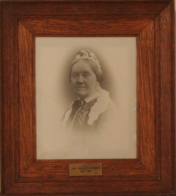
Photograph - Photographic Portrait, Mrs Charlotte Anderson
... at the State Library of Victoria (MS 12079). The reproduction... be held among Ruyton papers at the State Library of Victoria (MS ...Mrs Charlotte Anderson was born Charlotte Eliza Alsop in England in 1838 and arrived in Australia in 1848. She married lawyer James Anderson in 1864, and in the year of his death in 1878 she became the founding owner-Principal of Ruyton Girls' School, Kew. Mrs Anderson operated Ruyton initially in her own home of 63 Bulleen Road, Kew (now 63 High Street South). According to Ruyton histories, Mrs Anderson is said to have begun the school with her own two sons, four daughters and some of her Alsop nieces and nephews who resided in Kew. Around the time of the addition of Maud King, the first student outside the family, the school changed to a 'Ladies College', and the boys were sent elsewhere for their education. By late 1881 Mrs Anderson began using the name 'Ruyton' for the school, in honour of a connection to Ruyton-XI-Towns, Shropshire, England where her great-grandfather had been vicar and where she was baptised. In 1882 Mrs Anderson moved the School to Edgecomb in Studley Park Road from 1882-1888. The larger premises enabled her to begin accepting boarding students from 1882. She retired due to ill health and sold the school to her friend Miss Eliza Bromby. Mrs Anderson lived at 'Bongamero', in the King Valley, Victoria until her death in 1906. She is buried in Boroondara Cemetery. One of Ruyton's four Houses, Anderson, is named for Charlotte Anderson. Artwork AC/0099 is a framed reproduction photograph of an original portrait of Mrs Anderson, c.1900-1906. The location and date of the original photograph is unknown, but may be held among Ruyton papers at the State Library of Victoria (MS 12079). The reproduction was probably created to be part of the gallery of Principals and significant people for the Conference/Boardroom, Henty House.A framed, black & white reproduction of a photographic portrait. The portrait shows the head and shoulders of a middle aged woman wearing Victorian-era clothing including a dark ribbon tied around her collar. She wears a lace cap on her head, and the cap's tail is draped around her shoulders. The woman's body is partially turned away from the camera, while her face is turned toward the camera. Plaque on frame: "Mrs Charlotte Anderson/ 1878-1888"charlotte anderson, ruyton, ruyton girls' school, kew (vic), bulleen road, high street south, studley park road, edgecomb, woman, school, teacher, principal, anderson, reproduction, 1990s -
 Surrey Hills Historical Society Collection
Photograph, Grovedale Road Quarry in the 1920s - looking south, c1920
... Maling's Estate subdivision flyer on the State Library... on the State Library of Victoria's website. This shows ...The quarry was part of John Butler Maling's property. He was one of the original settlers of the area and farmed the area between Weybridge Street and Whitehorse Road. Clay was quarried from part of this area and used to make the bricks used in the construction of his home, known as 'Ancyra'. This is still extant at the corner of Weybridge and James Streets. Maling grazed cows and used the quarry as a water source. He was the uncle of John Butler Maling, Mayor of Camberwell. He was married to Kate Conlon in 1882. They had 3 children: Silas Young, Alick and Zillah. Maling was born in c1829 in Shepreth, Cambridgeshire; he died in Surrey Hills on 9 October 1912 and is buried in Box Hill Cemetery - CE-*-0586. Mrs Kate Maling (born c1859 in Co Meath, Ireland) died at the property on 8 March 1921. She is buried in Brighton General Cemetery. Probate was valued at over 10,000 pounds and included other properties in Sandringham, Hawthorn and Macedon. At the time of her death the Surrey Hills property was described as being 23 acres with 2 brick houses, 1 cow, 2 heifers and 40 fowls or chickens. The property was subdivided after her death. The property was subdivided into 110 house blocks in c1923 - see Maling's Estate subdivision flyer on the State Library of Victoria's website. This shows that the Grovedale Park site had been acquired by Camberwell Council by this time. An attached newspaper clipping documents prices realised for a cross-section of blocks. The MMBW map of 1925, also on the SLV website, shows the outline of the clayhole / quarry. The quarry was filled in after several drownings or near drownings and the land is now occupied by a park and playground, known as Grovedale Road Park, maintained by the City of Boroondara. Beckett Park is sited on horizon to the left beyond the trees. This documents the landscape prior to close settlement and is material to early building and farming in the Surrey Hills area.Black and white photo of the quarry between Grovedale Road and James Street taken in the 1920s and looking south. In the foreground is an area of water with reeds in the LH corner. Beyond on the high banks there are single storey houses in the background and (?) some light poles. An object that looks like a tank on posts is in a cutting on the far bank.quarries, grovedale road, james street, clay quarries, farming, kate conlon, kate maling, john butler maling, ancyra