Showing 112623 items matching "tracks/roads"
-
 Lakes Entrance Historical Society
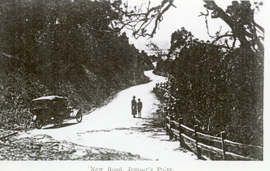
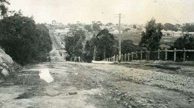
Photograph - Princes Highway Lakes Entrance, 1920c
Black and white photograph of the newly formed Princes Highway. It shows the steep cutting into the Jemmys Point hill, the winding road, the post and rail fence, two people and car of the era on road. Lakes Entrance VictoriaNew Road Jemmy's Pointtopography, waterways, roads and streets, fences -
 Marysville & District Historical Society
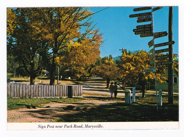
Postcard (item) - Colour postcard, Nucolorvue Productions Pty. Ltd, Sign Post near Pack Road, Marysville, Pre 2009
A colour photograph of the sign post that once stood opposite Pack Road in Marysville in Victoria.A colour photograph of the sign post that once stood opposite Pack Road in Marysville, Victoria. This corner was known as Signpost Corner. This postcard was produced by Nucolorvue Productions as a souvenir of Marysville.NU-COLOR-VUE/ OF/ AUSTRALIA MARYSVILLE, VICTORIA./ Sign post opposite Pack Road at/ Autumn. PLACE/ STAMP/ HERE POST CARD NCV.170 - NUCOLORVUE PRODUCTIONS PTY. LTD./ COPYRIGHT Printed in Australiamarysville, victoria, sign post, postcard, souvenir, nucolorvue productions, signpost corner, pack road -
 Mt Dandenong & District Historical Society Inc.
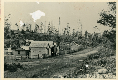
Photograph, Main Street Olinda c1908
c1908 view of Main Street Olinda with Dodd's store in foreground and Olinda State School up on the hill. Reverse of photograph has handwritten description by John Lundy-Clarke.Photo of Olinda taken about 1908 showing State School on skyline. Dodd’s store in foreground. Hodges blacksmith shop on roadside right. Coonara Road, then Mernda Road leads up out the picture right, Mt Dandenong Road goes down left. Range Road (the bullock track) is in immediate foreground and Sassafras turns to the right before the visible tracks on Mernda Road.olinda, jack dodd, general store, school -
 Kew Historical Society Inc
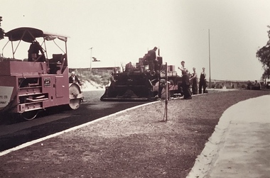
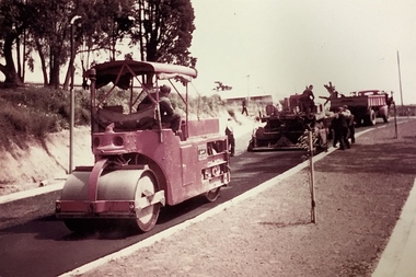
Photograph, Public Works, Road Construction, 1950s
An original photograph donated to the Kew Historical Society by the City's Engineering Department before the amalgamation of Kew into the City of Boroondara in 1994.While not all of the photographs are of Studley Park, Kew or East Kew, each photo provides a fine snapshot of the work of local government engineering departments of the period. They reveal they types of labour conducted, the techniques used and the equipment and machinery in the possession of the local government authority. Public works. Road making in the 1950s using a steam roller and a mechanical grader. Inscription on reverse: "Road making." city of kew (engineering department), road construction building, road maintenance -
 Kew Historical Society Inc
Photograph, Public Works, Road Construction, 1950s
An original photograph donated to the Kew Historical Society by the City's Engineering Department before the amalgamation of Kew into the City of Boroondara in 1994.While not all of the photographs are of Studley Park, Kew or East Kew, each photo provides a fine snapshot of the work of local government engineering departments of the period. They reveal they types of labour conducted, the techniques used and the equipment and machinery in the possession of the local government authority.Public works. Road making in the 1950s using a steam roller and a mechanical grader. Inscription on reverse: "Road making." city of kew (engineering department), road construction -
 Ringwood and District Historical Society
Photograph, Mansourah Picture Framing, Buildings in Canterbury Road Heathmont, February 1960, Feb-60
Peter Le Get found three framed photos of Heathmont view in a Heathmont Opportunity Shop. Previous owners unknown.Framed photograph of buildings in Canterbury Road Heathmont, February 1960.Heathmont, February 1960, Canterbury Road -
 Linton and District Historical Society Inc
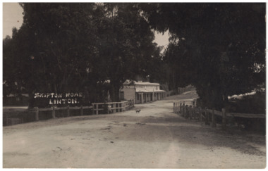
Photograph - Postcard, Murrell's Victoria Hotel, Skipton Road, Linton
Black and white postcard image of building on Skipton Road, Linton.Text, front: " SKIPTON ROAD / LINTON. "hotels, linton -
 Kew Historical Society Inc
Photograph - Construction of the electric tram line in Riversdale Road, Camberwell
One of a series of photographs, taken by Edgar James Dower in the second decade of the twentieth century. Born and raised in Olinda, his family later moved to Surrey Hills. He worked as an adult as a clerk in the city office of the Metropolitan Gas Company, and in his role as a 'collector', he was able to photograph scenes including the construction of tramlines, railways and associated buildings in Kew, Hawthorn, Camberwell and Surrey Hills. Later he established a real estate agency with his brother - the E.J. Dower Real Estate Agency, Dandenong Office.The image is an historically significant record of the development of transport infrastructure which was used to connect Victorians in the first two decades of the twentieth century. This development resulted from increases in population and the consequent extension of Melbourne's suburbs. The photographs, both individually and collectively, richly detail the labour of workers and the tools and machinery used to create and extend Melbourne's public transport network in the years preceding and during World War 1.Digital copy of an original mounted photograph showing workers excavating Riversdale Road, Camberwell, in preparation for the laying of the new electric tramline.Verso: "Riversdale Road between Wattle Valley and Highfield Roads"theme -- connecting victorians by transport and communications, riversdale road - camberwell (vic.), theme -- travelling by tram -
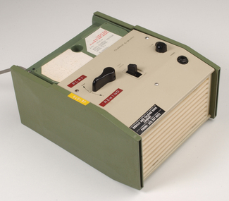 Vision Australia
Equipment - Object, Specto Ltd, Clarke and Smith talking book machine with tapete
In 1965 the Clarke & Smith Talking Book Cassette Cartridge made it's debut at the Olympia Show. Popularly known as a 'tapete', it weighed considerably less than the earlier book cassette cartridges and allowed for up to 6 tracks (13 hours recording time) to be played.Clarke and Smith talking book cassette cartridge player consisting of plastic rectangular case with buttons for navigational controls, light green front and top of machine and darker green on sides, power cord and 5 buttons. Also includes tapete "Words for murder perhaps" by Edward Candy and ready by Stanley Pritchard.Clarke & Smith Track change Play -- Off Volume Phones This equipment remains the property of the Braille & Talking Book Library, 31-51 Commercial Road, South Yarra, 3141. Phone: (03) 267 6022 Dyna Tape labels: J21075 Play Rewindaudio equipment, clarke and smith -
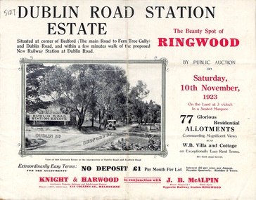 Ringwood and District Historical Society
Pamphlet, Land Sale Brochure, Dublin Road Station Estate - 1923
"Extracts from Recent Daily Newspaper - Ringwood Train Service - STATION WANTED AT RINGWOOD EAST. A deputation from the Ringwood East Railway League and Progress Association waited on the chairman of the Railway Commissioners yesterday afternoon and asked that a railway station be erected at Dublin-road, a mile and a quarter from Ringwood. The deputation urged that there were 81 passengers who, if the station were provided, would make daily use of it, and that as the Commissioners had purchased a site for a station at Dublin-road it was evident they had at one time considered it the most suitable site. The Chairman of Commissioners stated that the estimated cost of the station was £3700. Land owners in the locality should pay a proportion of the cost. Members of the deputation replied that there would be no difficulty in raising the money."Multi-fold brochure advertising public auction of residential allotments on Saturday, 10th November, 1923. Brochure includes subdivision features, local facilities and photographic images of the area and details of proposed new railway station at Dublin Road.Subdivision plan includes Dublin Road, Alexandra Road, Vonadawn Avenue, Green Street, Howard Avenue, Wood Street, and Bedford Road (Main Ferntree Gully Road). Auctioneer - Knight & Harwood, 315 Collins Street, Melbourne, Phones Central 10615, 10616. Agent - J.B. McAlpin, Opposite Railway Station, Ringwood, Phone Ringwood 7. -
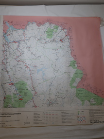 Kiewa Valley Historical Society
Map - Road Construction Authority 1986, Ref. Tallangatta 282008
Government authorities updated maps regularly.Historically of interest eg. 1. Pre dates the Alpine National Park. 2. 'Mt Beauty Estates' now known as Tawonga South. 3. Mt Niggerhead is named - It is now known as Mt Jaithmathang having been renamed in 2009.Colored map dated 1986 titled Road Construction Authority with an update of roads in the local Shires. It names places in the area and has a legion describing the rating of the roads and tracks. It also shows the main towns in the area and their roads.road construction authority, map of tallangatta area -
 Phillip Island and District Historical Society Inc.
Photograph
Part of collection donated to the Museum by Mr. Bernard Grayden. 1975View of man driving horse and cart with dog, crossing bridge on unmade road (Road to Nobbies)The Road to the Nobbies, Cowes Phillip Island, Victoria. The Rose Series P3427local history, documents, postcards, horse and cart, cowes, phillip island, sepia postcard, bridge -
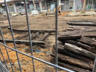 Ballarat Tramway Museum
Photograph - Digital image, Paul McConville, Removal of Bridge St track, July 2023
Set of five digital images of the removal of track in Bridge St Ballarat as part of the redevelopment of the area and its reopening to motor car traffic July 2023. See also August 2023 issue of Fares Please! page 15 for other photos and page 4 for a short item. Photos by Paul McConville and Richard Gilbert.Yields information about the redevelopment of Bridge St Ballarat from a Mall back to an open road.Set of five digital images showing the removal of the track in Bridge St Ballarat.tramways, ballarat, bridge st, track removal -
 Glen Eira Historical Society
Album - Album page, Hawthorn Road, Circa 1972
This photograph is part of the Caulfield Historical Album 1972. This album was created in approximately 1972 as part of a project by the Caulfield Historical Society to assist in identifying buildings worthy of preservation. The album is related to a Survey the Caulfield Historical Society developed in collaboration with the National Trust of Australia (Victoria) and Caulfield City Council to identify historic buildings within the City of Caulfield that warranted the protection of a National Trust Classification. Principal photographer thought to be Trevor Hart, member of Caulfield Historical Society. Most photographs were taken between 1966-1972 with a small number of photographs being older and from unknown sources. All photographs are black and white except where stated, with 386 photographs over 198 pages. 17 Hawthorn Road, North Caulfield is a contributory building to HO14 Caulfield North and environs, Caulfield North - Heritage Precinct in the City of Glen Eira.Page 83 of Photograph Album with five portrait photographs of 3 different properties on Hawthorn Road. Addresses are handwritten underneath each property.Handwritten: 17 HAWTHORN ROAD [under top left photo] / 17 HAWTHORN ROAD [under middle left photo] / 17 HAWTHORN ROAD [under bottom left photo] / 158-162 HAWTHORN ROAD [under top right photo] // STATE SAVINGS BANK CAULFIELD WEST BRANCH / 144 HAWTHORN RD / WEST SIDE - SOUTH OFF BALACLAVA ROAD [under bottom right photo] / 83 [bottom left] trevor hart, caulfield, hawthorn road, verandahs, houses, shops, banks, state savings bank, caulfield west, caulfield north, tudor style, victorian style -
 Greensborough Historical Society
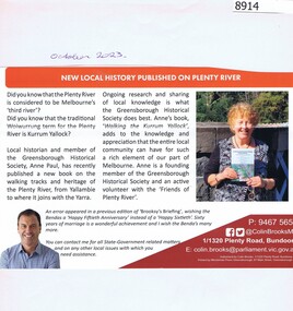
Article - Newsletter Clipping, Colin Brooks, New Local History published on Plenty River, 2023
Article about Anne Paul's book, "Walking the Kurrum Yallock" regarding the walking tracks and heritage of the Plenty River, from Brooksy's BriefingPrinted article about book written by Anne Paul regarding th walking track and heritage of the Plenty River from Brooksy's Briefingplenty river, anne paul, greensborough historical society, colin brooks -
 Glenelg Shire Council Cultural Collection
Photograph - Photograph - Dutton Way, 1976
Port of Portland Authority ArchivesBack: Dutton Way - pencil, lines leading to grey stamp. Location Date 30.6.76 - blue biro Time Reference 74/15 - blue biro -
Federation University Historical Collection
Flyer, QR codes used during the Covid 19 Pandemic
In the year 2020 there was a world wide pandemic of the Covid 19 Virus and QR codes were used to check into locations so outbreaks of the virus could be tracked to prevent further spread.A4 and A5 Sheets with QR codes used during the Covid 19 pandemic to chack into locations to keep track of outbreaks pandemic, covid 19, qr code, federation university -
 Marysville & District Historical Society
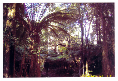
Photograph (item) - Colour photograph, 15-05-2008
A colour photograph of the walking track that leads to Keppel Falls near Marysville in Victoria.A colour photograph of the walking track that leads to Keppel Falls near Marysville in Victoria. Keppel Falls are named after the Keppel Family who were one of Marysville's earliest pioneering families.2008 05 15keppel falls, marysville, victoria, waterfalls, walking track, keppel family -
 Marysville & District Historical Society
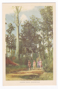
Postcard (item) - Colour tinted postcard, Nucolorvue Productions, Hikers Track, Marysville, c1950s
An early colour photograph of a group of ladies walking along a track in Marysville in Victoria.An early colour tinted potograph of a group of ladies walking along a track in Marysville in Victoria. This postcard was produced by Nucolorvue Productions in Elwood, Victoria as a souvenir of Marysville.POST CARD NUCOLORVUE PRODUCTIONS, ELWOOD, VICTORIAwalking track, marysville, victoria, nucolorvue productions, postcard, souvenir -
 Ringwood and District Historical Society
Photograph, Looking south down Warrandyte Road, Ringwood around 1920
Black and white photograph taken just below where Mullum Mullum Road meets Warrandyte Road.The Mullum Mullum Bridge can be seen in the dip, with numerous houses on the ridge on Whitehorse Road (Maroondah Highway). The fencing was post and rail, with Warrandyte Road unmade, sealed with crushed rocks. -
 Marysville & District Historical Society
Photograph (Item) - Black and white photograph, Camp Opposite The "Scandinavians', c1900
An early black and white photograph of a camp which was opposite The Scandinavian's Hotel and Boarding House along the Yarra Track.An early black and white photograph of a camp which was opposite The Scandinavian's Hotel and Boarding House along the Yarra Track. The Yarra Track is the former name of the gold fields road from Healesville to the Woods Point and Jordan Goldfields, in Victoria, Australia. A direct route via the Yarra River and the Great Divide was discovered by Rieck in September 1862 and became known as the Yarra Track. Early in 1863, the Victorian Government decided to construct a 193-kilometre (120 mile) road along the route. Its original width varied between 4 and 6 metres (12 and 20 feet), and was designed to accommodate horse-drawn vehicles. The Track involved the climbing of the Black Spur, descent into the Acheron Valley, and then through Marysville to the Cumberland where it followed the existing route.ARMSTRONG COLLECTION 42 STATION STREET/ SANDRINGHAM 3191/ TEL. (03) 9521 5442/ IAN M.L. ARMSTRONG OAMthe scandinavians', yarra track, healesville, wood's point, jordan goldfields, victoria, yarra river, great divide, reick, black spur, acheron valley, marysville, cumberland creek -
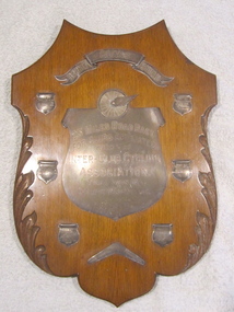 Geelong Cycling Club
Shield, 1918
Shield awarded to winners of Barnett Glass 25 Mile Road Race 1918. Shield put out by the Barnet Glass Company. After winning the shield for 3 years in a row, the recipient club was awarded the shield. This was the Geelong West Cycling Club.Wooden Shield with nickel plated plaques inscribed with winners names of Geelong Cycling Club 25 mile road race from 1918-1923"BARNETT GLASS SHIELD/ 25 MILES ROAD RACE/FOR CLUBS AFFILIATED/WITH THE/INTER CLUB CYCLING/ASSOCIATIO/FINAL WON BY GEELONG WEST CYCLING/CLUBgeelong cycling club; geelong west cycling club; shield; h.a. boyle; w. costello; f. king; norm hisham; jim holden; s. wells; barnett glass shield; 25 mile road race; 1918; -
 Kew Historical Society Inc
Photograph - Railway level crossing in Glenferrie Road, Glenferrie, E.J. Dower, 1912
One of a series of photographs, taken by Edgar James Dower in the second decade of the twentieth century. Born and raised in Olinda, his family later moved to Surrey Hills. He worked as an adult as a clerk in the city office of the Metropolitan Gas Company, and in his role as a 'collector', he was able to photograph scenes including the construction of tramlines and associated buildings in Kew, Hawthorn, Camberwell and Surrey Hills. Later he established a real estate agency with his brother - the E.J. Dower Real Estate Agency, Dandenong Office.The image is an historically significant record of the development of transport infrastructure which was used to connect Victorians in the first two decades of the twentieth century. This development resulted from increases in population and the consequent extension of Melbourne's suburbs. The photographs, both individually and collectively, richly detail the labour of workers and the tools and machinery used to create and extend Melbourne's public transport network in the years preceding and during World War 1.Digital copy of an original mounted photograph showing Glenferrie Road Hawthorn, looking north towards the old railway level crossing that existed before the line was elevated on a bridge over Glenferrie Road. "The Don Store" at right is immediately behind the old railway level crossing. The tree and shops at left before the crossing were to be removed / demolished as part of the realignment of the train tracks.Annotated verso: "Glenferrie Road, Glenferrie, showing railway gates and Walker's Store / Taken prior to the construction of electric tramline and the regrading of Camberwell Railway Line / Taken by E.J. Dower about 1912".theme --- travelling by tram, theme -- connecting victorians by transport and communications, glenferrie road -- hawthorn (vic.), railways -- hawthorn, the don store -- hawthorn (vic.) -
 Glen Eira Historical Society
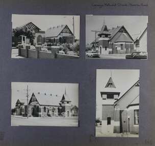
Album - Album page, Carnegie Methodist Church, Neerim Road, Circa 1972
This photograph is part of the Caulfield Historical Album 1972. This album was created in approximately 1972 as part of a project by the Caulfield Historical Society to assist in identifying buildings worthy of preservation. The album is related to a Survey the Caulfield Historical Society developed in collaboration with the National Trust of Australia (Victoria) and Caulfield City Council to identify historic buildings within the City of Caulfield that warranted the protection of a National Trust Classification. Principal photographer thought to be Trevor Hart, member of Caulfield Historical Society. Most photographs were taken between 1966-1972 with a small number of photographs being older and from unknown sources. All photographs are black and white except where stated, with 386 photographs over 198 pages. From Victorian Heritage Database citation for HO47 Uniting Church, 254 Neerim Road https://vhd.heritagecouncil.vic.gov.au/places/42432 (as at 28/10/2020) The former Methodist church (now Uniting church) complex at 252-54 Neerim Road, Carnegie, consists of the original timber church of 1886, the present brick Arts and Crafts influenced church of 1914, designed by A. Phipps Coles, the timber hall attached to the original church, built during the interwar period and the present brick hall of 1933, designed by J.F. Snell. From Victorian Heritage Database citation for HO47 Uniting Church, 254 Neerim Road https://vhd.heritagecouncil.vic.gov.au/places/42432 (as at 28/10/2020) The complex has aesthetic, historical and social significance. Its aesthetic value is derived from the extreme simplicity of the original church and the highly picturesque, eclectic, Arts and Crafts influenced character of the main church and hall. Its historical value rests in the early date of the original building and the manner in which the remaining buildings are representative of the principal period of settlement of the locality. The social significance derives from the use of the site as a place of worship since the commencement of the closer settlement of Carnegie from as early as 1886. Page 146 of Photograph Album with four photographs (3 landscape, 1 portrait) of Carnegie Methodist Church, Neerim Road.Handwritten: Carnegie Methodist Church Neerim Road [top right] / 146 [bottom right]trevor hart, neerim road, carnegie methodist church, church, toolambool road, wesleyan methodist church, breslin gallery, anthony breslin, 1910's, american romanesque, spire, half gabled tower, art, gallery, cafe, arched doorways, red brick, uniting church, carnegie, arts and craft style, a p coles, a coles, j f snell, j snell, halls -
 Mt Dandenong & District Historical Society Inc.
Photograph, Jasper Road Near Erith Lane 1920, 1920
View of Jasper Road, near Erith Lane taken in 1920. The road is tree lined with two significant gum trees in the foreground. This photograph has a detailed inscription on the back handwritten by John Lundy-Clarke in 1974.Jasper Road near Erith Lane 1920. This road has only a narrow right of way. It was put in as a road to serve “Cherry Farm”, connecting it to the Coach Road at the Elbow in 1904. It joins a wide surveyed road running from Inverness Road to the Coach Road at the Elbow and could possibly have been surveyed by Thomas Hand at the same time as Inverness Road. The name Jasper now applies to full length between Erith Lane and Coach Road. McGivern Bros widened it in 1937 and J L Clarke removed and stored much of the rock quarried in the widening. This was later sold to Dick Moorby who sold it to the builders of St Michaels Church in Falls Road. Comment by John Lundy-Clarke 10.5.1974 jasper road, erith lane, john lundy-clarke -
 Otway Districts Historical Society
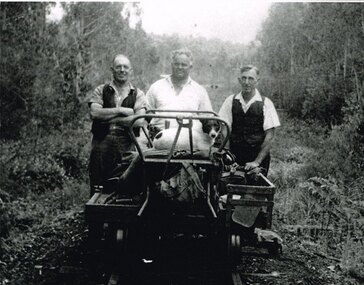
Photograph, Albert Denning, Colac track gang near Kawarren, c.1950
In 1955 staff numbers were reduced to an absolute minimum with one track gang at Beech Forest and one at Colac, one of whose members resided at Gellibrand. No new sleepers were issued to the track gangs after 1955/56, cut down ones being used instead. Albert Denning, the son of a Gellibrand selector, worked at Driver's planing mill and Hitt's Lardner mill before joining Victorian Railways in 1928 as an engine cleaner at Beech Forest and Crowes, the last one in both places. He later became a track repairer at Gellibrand and worked with this and the Colac track gang until 1962. Bill Jamieson was a track repairer on the Colac-Gellibrand gang from the 1950s until 1962, and witnessed the official policy of minimum maintenance in the last years of the line.B/W. 201mm x 254mm. In c.1950, the Colac track gang near Kawarren, featuring, from left to right, Bill Jamieson, Albert Denning, and Don Loury on an NKS motor trolley..colac; kawarren; railways; track gangs; -
 Mt Dandenong & District Historical Society Inc.
Photograph, View From Seat of Jeeves Coach, c1921
View the driver would have from horse drawn coach. CRB (Main) Road between Wombat Road and Falls Road. c1921. This photograph has a detailed inscription on the back handwritten by John Lundy-Clarke in 1974.View from seat of Jeeves Coach over horses while being driven along the new CRB road between Wombat Road and Falls Rd 1921.wombat road, falls road, crb road, jeeves coach, horse -
 City of Kingston
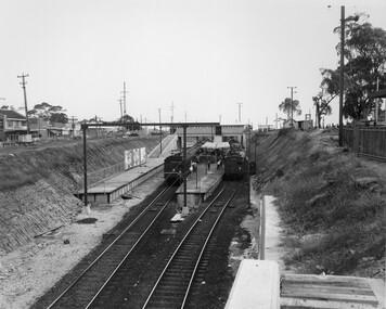
Photograph - Black and white, Public Transport Corporation, c. 1959
Black and white photograph of Moorabbin railway station, at the completion of works to relocate it to below street level. There are two "red rattler" trains pulled in to the station, utilising each of its two tracks and two of its three platforms. A third platform is visible to the left of the image, but no tracks have been laid to allow for an additional train. This image is part of a larger collection of images from the Public Transport Corporation displaying train stations and streetscapes in what is now the City of Kingston.Black and white photograph of Moorabbin railway station, at the completion of works to relocate it to below street level. There are two "red rattler" trains pulled in to the station, utilising each of its two tracks and two of its three platforms. A third platform is visible to the left of the image, but no tracks have been laid to allow for an additional train. Stamped in blue ink on reverse: COPYRIGHT / Public Transport Corporation / For re-ordering photographs / Please quote negative No M6859 / Enquiries C/- PTC Photographic Unit / Telephone switchboard 619 111moorabbin, railway station, red rattler, public transport -
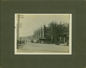
 Kew Historical Society Inc
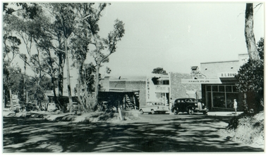
Photograph - Kew Junction during road widening, December 1958
Kew Junction is the intersection of five major roads - Denmark Street, High Street, High Street South, Studley Park Road and Princess Street. The original widening of High Street in the 1930s expanded that street by removing shops on the south side of the street from Cotham Road to Denmark Street. Further widening in 1958 removed shops at the west end of High Street to allow for increased traffic using Princes Street and Denmark Street.Original, black and white positive of Kew Junction, including the corner with Denmark Street during road widening in the 1958.Inscribed verso: "Kew Junction Dec 1958 / When the road was being widened by the removal of a number of shops / Notice saying Retchford's Estate agency's temporary office is at the top end of Denmark Street, Kew"kew junction, denmark street -- kew (vic.), major roadworks -- kew (vic.) -
 Melbourne Tram Museum
Slide, Keith Kings, 19/05/1968 12:00:00 AM
35mm Kodak white cardboard colour slide by Keith Kings of - Suction track cleaner No. 6, 19/5/1968, at South Melbourne Depot.Keith Kings stamp and number "24-5", with details of exposure. in ink "MMTB No. 6 Suction type track cleaning car Sth Melb Per Way yard 19/5/1968"trams, tramways, track cleaner, work trams, south melbourne depot, tram 6