Showing 15139 items matching "view"
-
 Numurkah & District Historical Society
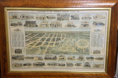
Map - Print in frame - Numurkah Township 1888, Supplement to the "Numurkah Standard" January 1888 View of Numurkah Victoria Australia
The late Hilda Morieson (very active in early Historical Society) owned the print. It was then passed on to Mary Morieson, then to Rosemary Kennet. It has been passed onto the Historical Society with permission from Ben Morieson, Hilda's grandsonLarge coloured print of supplement to Numurkah Standard 1888. Artist's view/impression of Numurkah streets (map) surrounded by artwork of a number of Numurkah businesses in the town and local district. The print is under glass in a faux-wood-grained framesee photo abovenumurkah standard, numurkah township map, numurkah businesses, 1888, print -
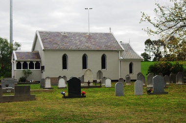
 Mt Dandenong & District Historical Society Inc.
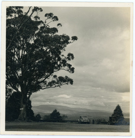
Photograph, View from Mt Dandenong Observatory Car Park. 1953, 1953
View from Mt Dandenong Observatory Carpark (now Sky High Restaurant) taken in August 1953. Large tree on LHS with sign reading 'LADIES'. Two old cars parked. Photograph taken by Sydney Walter Jackson.On back of photograph: From Mt Dandenong Aug 53mt dandenong, observatory, mt dandenong observatory -
![View of the Township of Fernshawe / [by] Nicholas Caire, circa 1876](/media/collectors/550653872162f11fb04854aa/items/57775425d0cdd10a5c17a3fd/item-media/57775483d0cdd10a5c17c7c0/item-fit-380x285.jpg) Kew Historical Society Inc
Kew Historical Society IncPhotograph, Anglo-Australasian Photographic Company, View of the Township of Fernshawe, c. 1876
Nicholas Caire was born on Guernsey in the Channel Islands in 1837. He arrived in Adelaide with his parents in about 1860. In 1867, following photographic journeys in Gippsland, he opened a studio in Adelaide. From 1870 to 1876 he lived and worked in Talbot in Central Victoria. In 1876 he purchased T. F. Chuck's studios in the Royal Arcade Melbourne. In 1885, following the introduction of dry plate photography, he began a series of landscape series, which were commercially successful. As a photographer, he travelled extensively through Victoria, photographing places few of his contemporaries had previously seen. He died in 1918. Reference: Jack Cato, 'Caire, Nicholas John (1837–1918)', Australian Dictionary of Biography, National Centre of Biography, Australian National UniversityAn original, rare photograph from the series 'Views of Victoria: General Series' by the photographer, Nicholas Caire (1837-1918). The series of 60 photographs that comprise the series was issued c. 1876 and reinforced a neo-Romantic view of the Australian landscape to which a growing nationalist movement would respond. Nicholas Caire was active as a photographer in Australia from 1858 until his death in 1918. His vision of the Australian bush and pioneer life had a counterpart in the works of Henry Lawson and other nationalist poets, authors and painters.Albumen silver photograph mounted on board. [Note: This is the first of two copies of this photograph in the collection]printed in ink on support l.c.: VIEW OF THE TOWNSHIP OF FERNSHAWE. / COPYRIGHT REGISTERED. printed in ink on support reverse c.: VIEWS OF VICTORIA. / (GENERAL SERIES.) / No. 14. / VIEW OF THE TOWNSHIP OF FERNSHAWE. / Fernshawe may be considered the most romantic town in the Colony of Victoria. It is situated at the foot of / the Black Spur, and is surrounded by a great many high hills, such as Mounts Riddell, Juliet, Munday, and others, / which form the crossing range into Gipps Land. It has, no doubt, derived its name from the fact that it is the / greatest Fern-growing district in the Colony. printed in ink on support reverse l.c.l.: J.W. FORBES, Agent, printed in ink on support reverse l.c.: ANGLO-AUSTRALASIAN PHOTOGRAPHIC COMPANY, MELBOURNE. printed in ink on support reverse l.c.r.: 10 Temple Court, Collins Street West.nicholas caire (1837-1918), landscape photography, fernshawe -
![View of the Township of Fernshawe / [by] Nicholas Caire, circa 1876](/media/collectors/550653872162f11fb04854aa/items/57775578d0cdd10a5c183f96/item-media/577755dfd0cdd10a5c18731c/item-fit-380x285.jpg) Kew Historical Society Inc
Kew Historical Society IncPhotograph, Anglo-Australasian Photographic Company, View of the Township of Fernshawe, c. 1876
Nicholas Caire was born on Guernsey in the Channel Islands in 1837. He arrived in Adelaide with his parents in about 1860. In 1867, following photographic journeys in Gippsland, he opened a studio in Adelaide. From 1870 to 1876 he lived and worked in Talbot in Central Victoria. In 1876 he purchased T. F. Chuck's studios in the Royal Arcade Melbourne. In 1885, following the introduction of dry plate photography, he began a series of landscape series, which were commercially successful. As a photographer, he travelled extensively through Victoria, photographing places few of his contemporaries had previously seen. He died in 1918. Reference: Jack Cato, 'Caire, Nicholas John (1837–1918)', Australian Dictionary of Biography,An original, rare photograph from the series 'Views of Victoria: General Series' by the photographer, Nicholas Caire (1837-1918). The series of 60 photographs that comprise the series was issued c. 1876 and reinforced a neo-Romantic view of the Australian landscape to which a growing nationalist movement would respond. Nicholas Caire was active as a photographer in Australia from 1858 until his death in 1918. His vision of the Australian bush and pioneer life had a counterpart in the works of Henry Lawson and other nationalist poets, authors and painters.Albumen silver photograph mounted on board. [Note: This is the second of two copies of this photograph in the collection]printed in ink on support l.c.: VIEW OF THE TOWNSHIP OF FERNSHAWE. / COPYRIGHT REGISTERED. printed in ink on support reverse c.: VIEWS OF VICTORIA. / (GENERAL SERIES.) / No. 14. / VIEW OF THE TOWNSHIP OF FERNSHAWE. / Fernshawe may be considered the most romantic town in the Colony of Victoria. It is situated at the foot of / the Black Spur, and is surrounded by a great many high hills, such as Mounts Riddell, Juliet, Munday, and others, / which form the crossing range into Gipps Land. It has, no doubt, derived its name from the fact that it is the / greatest Fern-growing district in the Colony. printed in ink on support reverse l.c.l.: J.W. FORBES, Agent, printed in ink on support reverse l.c.: ANGLO-AUSTRALASIAN PHOTOGRAPHIC COMPANY, MELBOURNE. printed in ink on support reverse l.c.r.: 10 Temple Court, Collins Street West.nicholas caire (1837-1918), landscape photography, fernshawe -
 Eltham District Historical Society Inc
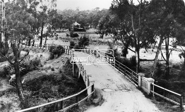
Negative - Photograph, View across bridge at Hurstbridge, Vic, c.1922
View across the new Monash bridge across the Diamond Creek at Hurstbridge looking towards the township, note steam train in centre background of image. Dated between the opening of bridge Nov. 1917 and provision of electric rail service Aug. 1926 - c.1922. Part of a slide show presentation "Bridges & Waterways of the Shire" by Russell Yeoman to the 13 September 1989 Society meeting. The presentation included slides of historic photos from the Shire of Eltham Pioneers collections as well as several recent views.This photo forms part of a collection of photographs gathered by the Shire of Eltham for their centenary project book ,"Pioneers and Painters: 100 years of the Shire of Eltham" by Alan Marshall (1971). The collection of over 500 images is held in partnership between Eltham District Historical Society and Yarra Plenty Regional Library (Eltham Library) and is now formally known as 'The Shire of Eltham Pioneers Photograph Collection.' It is significant in being the first community sourced collection representing the places and people of the Shire's first one hundred years.Digital image 4 x 5 inch B&W Negshire of eltham pioneers photograph collection, hurstbridge, bridge, steam train, diamond creek (creek), railway line, monash bridge -
 Greensborough Historical Society
Photograph - Digital Image, Ken Wandin, All Saints Anglican Church Greensborough. View from Church to Grimshaw Street 1970, 1970_
In 1970, All Saints' Anglican Church was rebuilt on the corner of Church and Grimshaw Streets Greensborough, replacing the timber church. This photograph shows the view from the new church to Grimshaw Street in 1970.Digital copy of colour photographall saints anglican church greensborough -
 Greensborough Historical Society
Photograph - Digital image, Marilyn Smith, St Katherine's Church St Helena: View of Church, 29/05/2015
St Katherine's Church St Helena dates from 1858. The Church was built by Major Anthony Beale in memory of his wife Katherine Rose Beale. This photograph shows a view of the Church.Digital copy of colour photographst katherines church st helena, anthony beale -
 Eltham District Historical Society Inc
Photograph, View at Warrandyte, Vic, c.1937
View looking southeast across the bridge to Warrandyte township. Taken from the northern side of the Yarra River from near present day 244 Research-Warrandyte Rd, North WarrandyteThis photo forms part of a collection of photographs gathered by the Shire of Eltham for their centenary project book,"Pioneers and Painters: 100 years of the Shire of Eltham" by Alan Marshall (1971). The collection of over 500 images is held in partnership between Eltham District Historical Society and Yarra Plenty Regional Library (Eltham Library) and is now formally known as the 'The Shire of Eltham Pioneers Photograph Collection.' It is significant in being the first community sourced collection representing the places and people of the Shire's first one hundred years.Digital image 4 x 5 inch B&W Negshire of eltham pioneers photograph collection, warrandyte, north warrandyte, warrandyte bridge -
 City of Ballarat Libraries
Photograph, View from West Ballarat Fire Station looking north west
View from the West Ballarat Fire Station looking north west looking towards Drummond and Errard Streets. Both the Base and St John of God Hospitals roofs and chimneys are seen.west ballarat fire station, ballarat, drummond street, errard street, base hospial, st john of god hospital -
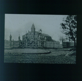 Vision Australia
Slide (item) - Image, View of RVIB from St Kilda Road, 1868?
View from St Kilda Road of driveway to newly completed RVIB building. Believed to be taken around opening in 1868, there are no trees visible except for one on the side road (Moubray Street).royal victorian institute for the blind, buildings -
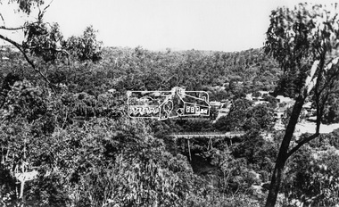
 Mt Dandenong & District Historical Society Inc.
Photograph, View From Doughty's Road 1974
John Lundy-Clarke grew up in the Kalorama/Mt Dandenong area and later in life (1972-74) began to write a comprehensive history of the area working from an original settlement map in an effort to cover all areas. This photograph shows approximately the same area as photograph number KAL0193 but is taken 60 years later. The trees have grown much taller and the buildings changed. On the site of the Paynter house 'Iona' there is now the 'Yosemite' (Villa Toscana) accommodation. The pavilion in the centre of the photo is the site of 'Kalorama', home of early pioneer Isaac Jeeves. The photograph is taken looking up towards The Gap (FiveWays).Black and white photograph showing a forested area with clear sites. Roofs of buildings can be clearly seen. Handwritten inscription on reverse by John Lundy-ClarkeView from near Doughty’s Rd looking north up valley to Kalorama Gap in Jan 1973. Tiny roof in centre is pavilion on site of “Kalorama”. Long roof to its left is Yosemite Motel on site of “Iona”.paynter, kalorama, iona, yosemite, villa toscana, five ways, the gap -
 Linton Mechanics Institute and Free Library Collection
Book - Novel, Blyth, James, With A View to Matrimony by James Blyth, 1904
Romance novel.Hardcover book, 283 pages. Book has a dark green cover.fictionRomance novel.james blyth, romance, fiction -
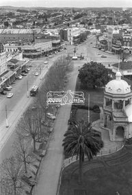
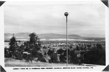 Stawell Historical Society Inc
Photograph, Panorama of Stawell from Pioneer's Memorial, towards the Black Range. Murray Views No.13
Murray Views No. 13. Panorama over Stawell, looking South West. Spotlight on Pioneer's Memorial (29,5). Black Range in background, grassland on Big Hill at front of Photo. St Patrick's Church visible, Kinsella House. The larger photo 29.5a is a slightly closer view of same scene and shows the "new" school (corner Patrick & Holt Street) opened in 1934.Two similar views of Stawell. One Murray views looing south west (29.5) and the other a larger photo showing school building beside church (29.5a).Murray Views No.13. Panorama from Pioneer's Memorial, showing Black Range, Stawell, Vic. (on 29.5)stawell, panorama -
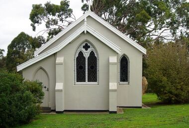 Greensborough Historical Society
Photograph - Digital image, Marilyn Smith, St Katherine's Church St Helena: Rear view of Church, 29/05/2015
St Katherine's Church St Helena dates from 1858. The Church was built by Major Anthony Beale in memory of his wife Katherine Rose Beale. This photograph shows the rear view of the Church.Digital copy of colour photographst katherines church st helena, anthony beale -
Glenelg Shire Council Cultural Collection
Photograph, View of Portland Harbour and Port, 1980s
Port of Portland Authority archives.Front: (no inscriptions) Back: (no inscriptions)port of portland, portland harbour, livestock woodchip -
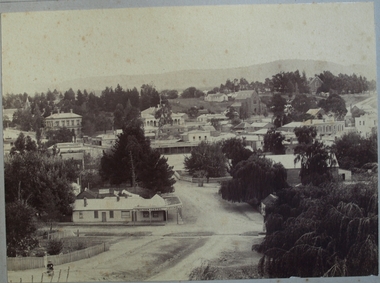 Clunes Museum
Photograph, VIEW OF CLUNES FROM SCHOOL HILL, CAMERON ST
.1 SEPIA ORIGINAL MOUNTED ON CARDBOARD - VIEW OF CLUNES FROM SCHOOL HILL, CAMERON STREET (ON REAR OF ORIGINAL - PHOTO OF HOUSE, LOCATION UNKNOWN .2 SMALL BLACK AND WHITE PHOTOCOPY OF ORIGINAL .3 BLACK AND WHITE PHOTOCOPY OF ORIGINALUNICORN HOTEL. NICHOLS.local history, hotels, unicorn -
 Whitehorse Historical Society Inc.
Photograph, 93 Central Road, Blackburn - View -3
Colour photograph of the house at 93 Central Road, Blackburn, purchased from William Elliott Wilson, by the Rev. John Flynn of the Australian Inland Mission, for his sister Rosetta Flynn in 1928. Photo shows view of house from street.central road, blackburn, no.93, wilson, william, elliott, flynn, rev. john, rosetta -
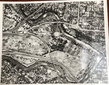 University of Melbourne, Burnley Campus Archives
Photograph - Black and white print, Aerial View of Burnley Campus C.1970, c. 1970
Colour photograph of black and white photograph. Aerial View of Burnley Campus. Enlargement. Shows position of Campus in bend of Yarra River after alterations to the position of the river due to building of Freeway, new ovals and Richmond Public Golf Course.burnley campus, aerial view, yarra river, richmond public golf course -
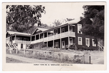 Marysville & District Historical Society
Postcard (Item) - Black and white postcard, Murray Views, MURRAY VIEWS NO. 26. "GREENLANDS", MARYSVILLE, VIC, Unknown
A black and white photograph of Greenlands guest house in Marysville that was produced by Murray Views as a souvenir of Marysville.A black and white photograph of Greenlands guest house in Marysville that was produced by Murray Views as a souvenir of Marysville.POST CARD REAL PHOTOGRAPH PRODUCED IN/ AUSTRALIA BY MURRAY VIEWS, GYMPIE, Q.marysville, victoria, australia, greenlands, the spot, green lanes, sarah mclean, murdock mclean, geoffrey cobb, cath m anderson, mr and mrs a.g. clarke, e pigdon, bert patterson, guest house, postcard, souvenir, murray views -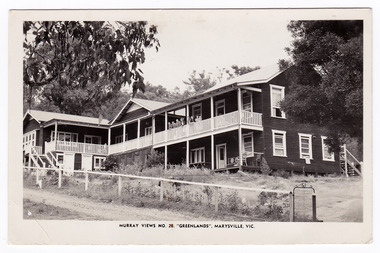
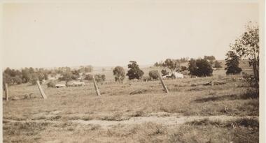 Greensborough Historical Society
Photograph - Digital image, View from Rose McLaughlin's house, Beales Road Greensborough 1937, 1937_
Part of a collection of photographs copied from the late Shirley Fraser (nee Black), also descendant of the McLaughlin and Whatmough family. This photograph shows the view from Rose McLaughlin's Beales Road home in 1937.This photograph shows the rural nature of Greensborough in the 1930s.Digital copy of black and white photograph.shirley fraser, rosalie mclaughlin, beales road -
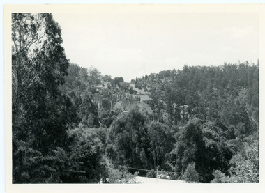
 Lake Bolac & District Historical Society
Black and white photograph, Aerial View of Lake Bolac, 1947
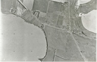
Aerial view of Lake Bolac (Boloke) taken in 1947. Fresh water lake at bottom left, salt lakes at top right, village at crossroads of north-south Glenelg highway and Ararat-Mortlake road.lake bolac, 1947, glenelg highway -
 City of Ballarat Libraries
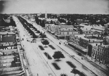
Photograph, Western view from Ballarat Town Hall Tower 1899
View from the Ballarat Town Hall Tower looking west. Buildings that can be seen are William Dawson Ironmonger and Walter Cornell Chemist. The slate roof of St Andrew's Kirk can also be seen.ballarat town hall tower, gardens, william dawson, walter cornell, commercial, st andrew's kirk, ballarat, ironmonger, chemist, church, sturt street -
 Ringwood and District Historical Society
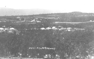
Photograph, Distant view of Ringwood from Loughnans Hill - 1912
Typed below photograph, "Distant view of Ringwood from Loughnans Hill - 1912. Big building top left with chimney is brickworks, in centre is old Catholic Church, Club Hotel, Big road top right is Maroondah Highway." -
 Ringwood and District Historical Society
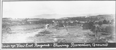
Photograph, Birds eye view East Ringwood - Showing Recreation Ground. Mt. Dandenong Rd. on right. Taken from present Civic Centre site. Football final in progress - 1923
Written below photograph, "Birds eye view East Ringwood - Showing Recreation Ground". Typed below photograph, "Mt. Dandenong Rd. on right. Taken from present Civic Centre site. Football final in progress - 1923". -
 Eltham District Historical Society Inc
Photograph, View of Bendigo from Post Office Tower, c.Aug. 1963
View looking northeast along the Midland Highway (Pall Mall) from the top of the Post Office tower, present day Post Office Gallery and Visitor Centre.. In the immediate foreground to left is the Bendigo Magistrates' Court.Digital TIFF file Scan of 35mm Ilford FP3 black and white negative transparencybendigo, george coop collection, pall mall, post office tower, bendigo magistrates' court, midland highway -
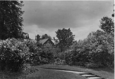 University of Melbourne, Burnley Campus Archives
Photograph - Black and white print, View Across Garden to Principal's Residence, 1913
Note by T.H. Kneen 19 November 1991, "View of Principal's residence from vicinity of orchard gate - the three steps in altered form still exist (1991). Middle ground plantation of camellias still exists."Looking across garden area from the Orchard with path and shrubs to back of Principal's Residence in background. There are more steps than are extant now.On reverse, "1913." principal's residence, lynch design, camellias, principal's house, orchard, field station -
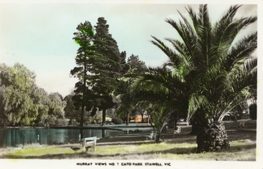 Stawell Historical Society Inc
Photograph, Cato Lake -- with palms & trees -- Coloured
Coloured Postcard Murray Views No. 7. Cato Park Stawell Victoria. The three black and white photos are missing the larger palm tree on the right in the foreground. The view is of the lake surrounded by trees and bench seating. One colour post card Murray View No 7 Cato Park Stawell Victoria plus two similar black & white photos one smaller the other an enlargement. Also a small B&W photograph in Album 14, p28. The post card is a view of a section of the lake surrounded by willows, 2 tall pine trees and one large palm tree on the right. The lake is also surrounded by 3 concrete & wood bench seats with maybe a 4th in the distance. Murray View No 7 Cato Park Stawell Vic. On the back "Post Card Real Photograph produced in Australia by Murray View, Gympie, Q".stawell -
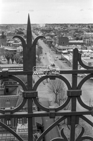
 Eltham District Historical Society Inc
Photograph, View of Bendigo from Post Office Tower, c.Aug. 1963
View looking southwest along the Midland Highway (Pall Mall) from the top of the Post Office tower, present day Post Office Gallery and Visitor Centre. In the immediate foreground is Soldiers Memorial Institute Military Museum.Digital TIFF file Scan of 35mm Ilford FP3 black and white negative transparencybendigo, george coop collection, pall mall, post office tower, soldiers memorial institute military museum -
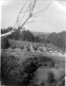 Ringwood and District Historical Society
Photograph, Frazer's orchard 'Alkoomi', North Ringwood c1963. View Northwards
Harold Frazer’s “Alkoomi” orchard, Oban Rd Nth Ringwood. View northwards of dam and logan berries in foreground. Neighbour Ah Goon’s orchard in background which fronted onto Williams Rd. Photo taken from top of pine tree, c1963.-