Showing 1122 items
matching waterway
-
 Lakes Entrance Historical Society
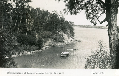
Postcard - Scone Cottage, Bulmer H D, 1945
'Scone Cottage' aka 'Cliff Crest' was a popular destination for tourists, who were conveyed to the boat landing by local tourist launches, whence the visitors climbed the steep zigzag path to the cottage.Black and white postcard showing a tourist launch leaving a rustic jetty below timbered cliffs at Nungurner near Lakes Entrance, Victoria.Boat Landing at Scone Cottage , Lakes Entrance. waterways, tourism, boats and boating, jetties -
 Lakes Entrance Historical Society
Postcard, 1970
Postcard has long personal message on reverse.Colour postcard taken at a bend in the Princes Highway approaching Lakes Entrance, showing a car travelling downhill, two cars parked with five people viewing the entrance from Bass Strait. Lakes Entrance Victoriawaterways, islands -
 Lakes Entrance Historical Society
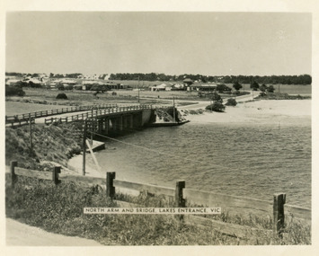
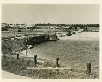
Postcard - Lakes Entrance, 1955
The Marine Parade has been formedBlack and white photograph of North Arm bridge Lakes Entrance VictoriaNorth Arm and Bridge Lakes Entrance, Vicwaterways, roads and streets, bridges -
 Lakes Entrance Historical Society
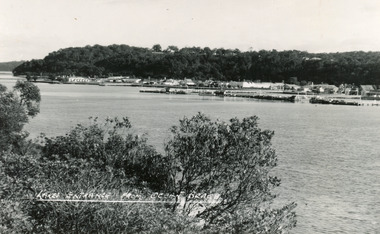
Postcard - Lakes Entrance, Bulmer H D, 1950
Black and white postcard of the township of Lakes Entrance, taken form the south bank of Cunninghame Arm, showing the boat haven, buildings along Esplanade, and the Kalimna escarpment in the distance. Lakes Entrance VictoriaLakes Entrance from Ocean Beachtownship, waterways -
 Lakes Entrance Historical Society
Postcard - Bullock Island Wharf, 1993
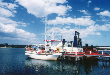
Date made January 1993Colour photograph showing boats refuelling at Bullock Island, Lakes Entrance, Fishermen's Co-op unloading area in background. Lakes Entrance Victoria waterways, jetties, boats and boating -
 Lakes Entrance Historical Society
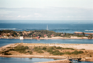
Photograph - The Entrance, Holding M, 1997
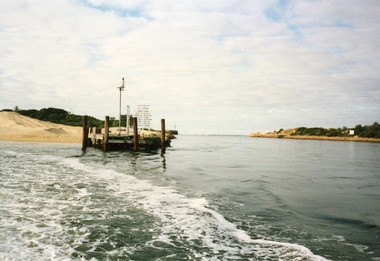
Colour photograph showing entrance channel and piers. Also shows enormous amount of sand dumped by Gippsland Ports. Lakes Entrance Victoriawaterways, piers, dredging -
 Linton and District Historical Society Inc
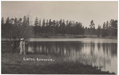
Photograph - Postcard, Linton Reservoir, circa 1906
Black and white postcard view of reservoir with trees in background. A man and a woman are standing to the left next to a tree. A wooden structure to the right in background.Text, front: 'LINTON RESERVOIR'.linton reservoir, waterways -
 Linton and District Historical Society Inc
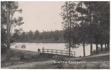
Photograph - Postcard, Linton Reservoir
Black and white postcard view of a reservoir surrounded by trees, with a man and a woman standing near jetty. Wooden structure just beyond jetty.Text, front: 'LINTON RESERVOIR'.linton reservoir, waterways -
 Lakes Entrance Historical Society
Book, Le Cheminant, Marion, Nyerimilang and its Neighbourhood, 1985
A history of Nyerimilang Homestead on the Gippsland Lakes at Kalimna West, from 1884 to 1985. Now the responsibility of National Parks.settlers, agriculture, timber industry, waterways, parks -
 Lakes Entrance Historical Society
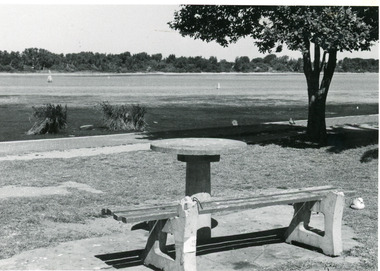
Photograph - Cunninghame Arm, Lakes Post Newspaper, 1992c
Black and white photograph of part of the lake and waterfront. It shows the scrub covered south shore, the Cunninghame Arm, the foreshore littered with dead seagrass, the path and lawn verge, and small concrete picnic table and broken seat. Lakes Entrance Victoria waterways, topography -
 Lakes Entrance Historical Society
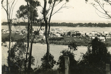
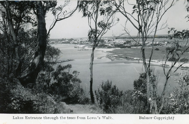
Postcard - North Arm, 1930 c
Second copy has inscription Glimpse of Lakes Entrance ( on back)Black and white small format postcard, taken from a tea room known as Cream Cottage on the Kalimna Heights escarpment. It shows posts & trees in foreground, waters of North Arm, cottage facing North Arm, rear view of dwellings facing Cunninghame Arm, Broomes Federal Baang Yarnda houseboat, sand hummocks on southern shore. Lakes Entrance Victoria'View from Cream Cottage' (on back)township, waterways -
 Lakes Entrance Historical Society
Photograph - Bullock Island, 1962
Image printed from 35mm slideColour photograph of Bullock Island showing cleared and grass planted south eastern area in preparation for relocation of Public Works and fishing industry facilities. Traffic access to island via humpy bridge. Lakes Entrance Victoriabridges, waterways, topography -
 Lakes Entrance Historical Society
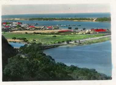
Postcard - Township, 1998c
Tinted small format postcard showing the township situated on the isthmus between two stretches of water the Cunninghame Arm and the North Arm. Work in progress widening the North Arm Bridge as seen by workmen's huts beside the southern approach. Lakes Entrance Victoriajetties, waterways, topography, township -
 Lakes Entrance Historical Society
Postcard - Township, 1935 c
Black and white photograph of a view from Kalimna Heights overlooking township. Shows North Arm, Marine Parade, Cunninghame Arm and sand hummocks with Bass Strait in distance. Lakes Entrance Victoriatownship, waterways -
 Lakes Entrance Historical Society
Photograph - Footbridge, Bulmer HD, 1940c
1 black and white copy 13x18 has glue on back|1 copy tinted 9x14Black and white photograph of the foot bridge over the Cunninghame Arm. It shows a concrete wall at the edge of lake in foreground, two light poles on the bridge buildings on Esplanade and Myer Street. Lakes Entrance VictoriaThe Footbridge Lakes Entrancebridges, waterways, township -
 Lakes Entrance Historical Society
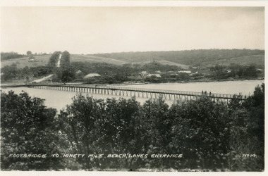
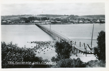
Postcard - Footbridge, No14 Bulmer HD, 1940c
1 same image 6.5x10.5 valentine Series donated by Keith West|1 other similar image 6.5 x 10.5|1 other similar image 9 x 14|1 other similar postcard, message on back in Spares BoxBlack and white small format postcard of the footbridge across the Cunninghame Arm, which is the access to the southern shore and ocean beach from the town. Lakes Entrance VictoriaFootbridge to Ninety Mile Beach, Lakes Entrance bridges, waterways, township -
 Lakes Entrance Historical Society
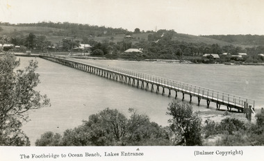
Postcard - Footbridge, 1937c
Copies as follows|One Miniture postcard tinted 6.5 x 9|One Black and white copy 6.5 x 11|One Tinted copy 20 x 28|One Postcard 17 x 12Black and white postcard showing waterfront, some buildings along esplanade, no buildings on Myer St Hill. Footbridge across Cunninghame Arm completed to high tide mark, ramp constructed later, scrub in foreground. Lakes Entrance VictoriaThe Footbridge to Ocean Beach Lakes Entrancevegetation, bridges, waterways, township -
 Lakes Entrance Historical Society
Postcard - Footbridge, 1937c
1 copy same|1 copy in poor condition- Mrs Helen Stokes|1 tinted copy. all same sizeBlack and white small format postcard of the footbridge over the Cunninghame Arm. It shows natural vegetation of the south shore in the foreground and residences and trees of the township and Myer Street ascending the hill in the background. Lakes Entrance Victoriawaterways, bridges, township -
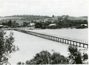
 Lakes Entrance Historical Society
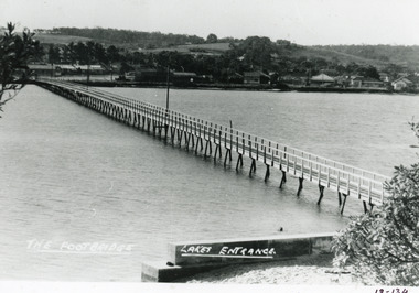
Postcard - Footbridge, Bulmer HD, 1940c
Black and white postcard of the footbridge over the Cunninghame Arm. It shows natural vegetation in the foreground the ramp extension to the bridge, rocks at waters edge town beyond northern shore. Lakes Entrance VictoriaThe Footbridge Lakes Entrance bridges, waterways, township -
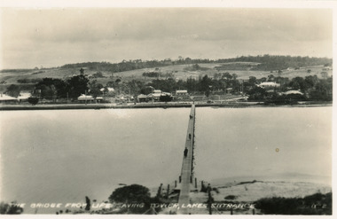 Lakes Entrance Historical Society
Postcard - Footbridge, Bulmer H D, 1940c
Black and white small format postcard of the footbridge over Cunninghame Arm, taken from the Royal lifesaving tower. Three people on footbridge, town beyond North Shore. Lakes Entrance VictoriaThe bridge from lifesaving tower Lakes Entrancebridges, waterways, township -
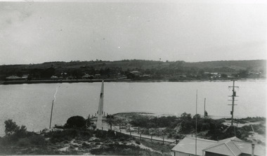 Lakes Entrance Historical Society
Photograph - Footbridge, 1943c
Black and white copy photograph of the footbridge over the Cunninghame Arm, taken from the lifesaving tower. Kiosk in foreground town beyond North Shore. Lakes Entrance Victoriabridges, waterways, township -
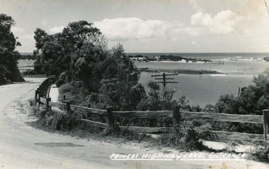 Lakes Entrance Historical Society
Postcard, Bulmer H D, 1920c
Black and white copy same sizeTinted postcard of a bend in the Princes Highway, Jemmys Point. It shows the road between the steep cutting and post and rail fence. Glimpse of footbridge to Bullock Island, entrance and hummocks. Lakes Entrance VictoriaPrinces Highway, Lakes Entrance topography, waterways, roads and streets -
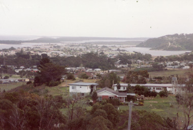 Lakes Entrance Historical Society
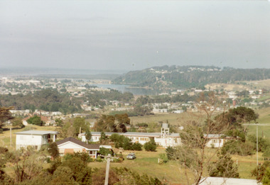
Photograph - Township, Fish, Marie, 1985c
\Colour photograph of township showing, North Arm and North Arm Bridge, Jemmys Point, Mount Barkly, Kalimna Heights on right, Cunninghame Arm and sand dunes on left. Looking towards Bullock Island and Rigby Island and Hopetoun Channel in centre background. Sea Vista flats in foreground. Photo take from near Telecom Tower on Merrangbaur Hill circa 1985. Lakes Entrance Victoria bridges, waterways, township -
 Lakes Entrance Historical Society
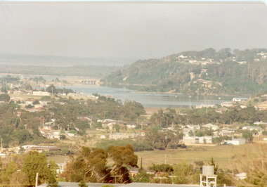
Photograph - Township, Fish, Marie, 1985c
Colour photograph of township showing, North Arm and North Arm Bridge, Jemmys Point, Mount Barkly, Kalimna Heights on right, Cunninghame Arm and sand dunes on left. Looking towards Bullock Island and Rigby Island and Hopetoun Channel in centre background. Sea Vista flats in foreground. Photo take from near Telecom Tower on Merrangbaur Hill circa 1985. Lakes Entrance Victoria bridges, waterways, township -
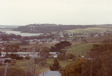
 Lakes Entrance Historical Society
Photograph - Township, Fish, Marie, 1985c
Colour photograph, image of part of township, showing Jemmys Point, Mount Barkly, North Arm and old North Arm bridge, football ground mid picture. View towards Rigby Island, Hopetoun Channel and dunes. Photo taken using telephoto lenses from near Telecom Tower on Merrangbaur Hill. Lakes Entrance Victoria bridges, waterways, township -
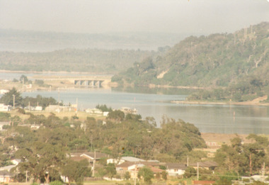
 Lakes Entrance Historical Society
Photograph - Township, Fish, Marie, 1985c
Colour photograph of township, showing buildings, Jemmys Point, Mount Barkly, Kalimna Heights, North Arm and old North Arm bridge, and Rigby Island beyond. Sea Vista flats in foreground. Photo taken from near Telecom Tower on Merrangbaur Hill. Lakes Entrance Victoriatopography, township, waterways, bridges -
 Lakes Entrance Historical Society
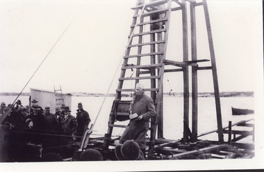
Photograph - Footbridge, Jemmeson Edie, 1936
One other copyBlack and white photograph of Albert Lind MP speaking to the crowd at the driving of the first pile to commence construction of the footbridge across Cunninghame Arm Lakes Entrance Victoria.construction, waterways, bridges -
 Lakes Entrance Historical Society
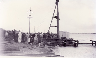
Photograph - Footbridge, Jemmeson Edie, 1936
One other copyBlack and white photograph of the crowd gathered to watch the first pile being driven to commence construction of the footbridge across Cunninghame Arm Lakes Entrance, Victoria.construction, waterways, bridges -
 Lakes Entrance Historical Society
Photograph - Township, Fish, Marie, 1985c
Colour photograph of part of township showing Jemmys Point, Mount Barkly, Kalimna Heights, North Arm & old North Arm bridge, looking beyond to Rigby Island. Photo taken from near Telecom Tower on Merrangbaur Hill. Lakes Entrance Victoriatopography, township, waterways, bridges -
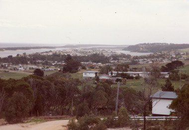 Lakes Entrance Historical Society
Photograph - Township
Colour photograph of township of Lakes Entrance showing North Arm, North Arm Bridge, Jemmys Point, Mount Barclay, Kalimna Heights, Cunningham Arm and sand dunes on left. Looking west to Bullock Island and Rigby Island. Photo taken from near Telecom Tower on Merrangbaur Hill. Lakes Entrance Victoria bridges, waterways, islands, township