Showing 1145 items
matching waterways
-
 Lakes Entrance Regional Historical Society (operating as Lakes Entrance History Centre & Museum)
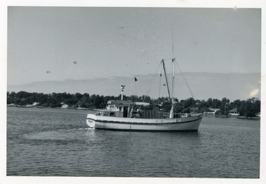
Photograph, Holding George, 1978c
... Waterways ...Black and white photograph of the fishing boat Minawie in Cunninghame Arm, cottages opposite in background. Lakes Entrance Victoriafishing industry, ships and shipping, waterways -
 Lakes Entrance Regional Historical Society (operating as Lakes Entrance History Centre & Museum)
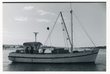
Photograph, Holding George, 1978c
... Waterways ...Black and white photograph of the fishing boat Minawie in Cunninghame Arm, cottages opposite in background. Lakes Entrance Victoriafishing industry, ships and shipping, waterways -
 Lakes Entrance Regional Historical Society (operating as Lakes Entrance History Centre & Museum)
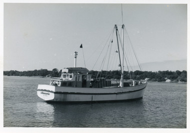
Photograph, Holding George, 1978c
... Waterways ...Black and white photograph of the fishing boat Minawie in Cunninghame Arm, cottages opposite in background. Lakes Entrance Victoriafishing industry, ships and shipping, waterways -
 Lakes Entrance Regional Historical Society (operating as Lakes Entrance History Centre & Museum)
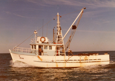
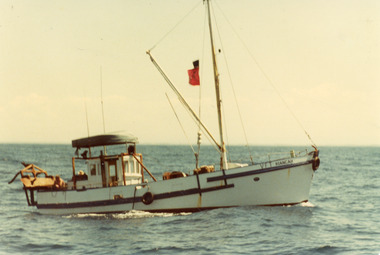
Photograph, 1980c
... Waterways ...'Dee Jay' built for ? Franks, later owned by Roy Carstairs, then to Win Hobson, Port AlbertColour photograph of fishing boat Dee Jay at sea off Lakes Entrance, Victoriafishing industry, ships and shipping, waterways -
 Lakes Entrance Regional Historical Society (operating as Lakes Entrance History Centre & Museum)
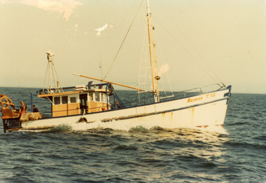
Photograph, 1980c
... Waterways ...Owner 'Labro'?? converted it then left the areaColour photograph of scallop boat Subron TVE at sea off. Two men working the dredge table. Lakes Entrance Victoriafishing industry, ships and shipping, waterways -
 Lakes Entrance Regional Historical Society (operating as Lakes Entrance History Centre & Museum)
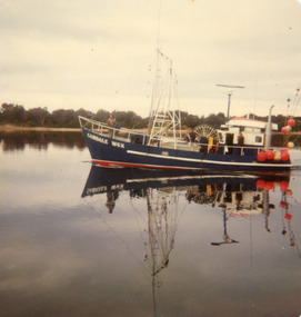
Photograph, 1980c
... Waterways ...Camdale thought to have gone to QLD 1980'sColour photograph of fishing boat Camdale reg no W6Y in Cunninghame Arm, Lakes Entrance, Victoriafishing industry, ships and shipping, waterways -
 Lakes Entrance Regional Historical Society (operating as Lakes Entrance History Centre & Museum)
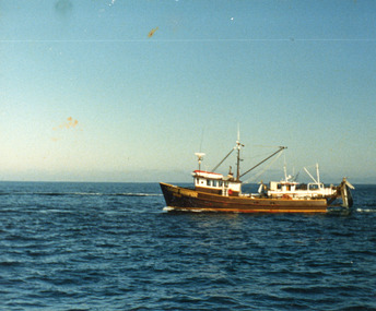
Photograph, 1975c
... Waterways ...Built by Bulls of Metung for Harry Rose 1956c for shark fishingColour photograph of scallop fishing boat Kiangah in Bass Strait off Lakes Entrance, Victoriafishing industry, ships and shipping, waterways -
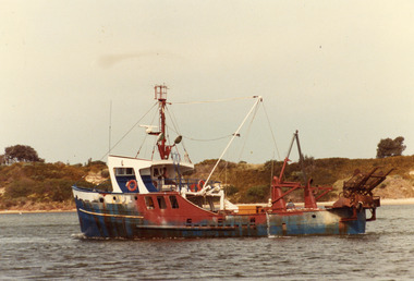
 Lakes Entrance Regional Historical Society (operating as Lakes Entrance History Centre & Museum)
Photograph, 1980c
... Waterways ...Owner Keith Bonds from NungurnerColour photograph of the scallop fishing boat Sand Groper working the scallop beds in Bass Strait. Boat in background working in opposite direction. Lakes Entrance Victoriafishing industry, ships and shipping, waterways -
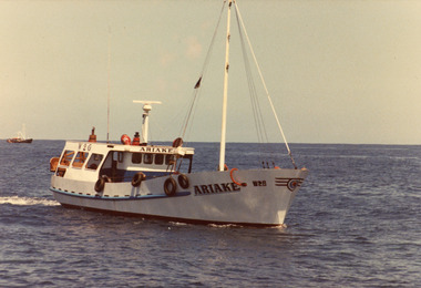 Lakes Entrance Regional Historical Society (operating as Lakes Entrance History Centre & Museum)
Photograph, 1980c
... Waterways ...Colour photograph of the scallop fishing boat Ariake at sea. Another fishing boat in distance. Lakes Entrance Victoriafishing industry, ships and shipping, waterways -
 Lakes Entrance Regional Historical Society (operating as Lakes Entrance History Centre & Museum)
Photograph, 1980c
... Waterways ...Former tug boat, owner Scott Horton, now at StanleyColour photograph of a scallop fishing boat known locally as the Bug Tug in Cunninghame Arm. Hill Sixty on hummocks in background. Lakes Entrance Victoriafishing industry, ships and shipping, waterways -
 Lakes Entrance Regional Historical Society (operating as Lakes Entrance History Centre & Museum)
Photograph, 1975c
... Waterways ...Colour photograph of the scallop fishing boat Posidon in Cunninghame Arm. Identified by registration number U7L. Later painted black with white trim. Scrub covered hummocks in background. Lakes Entrance Victoriafishing industry, ships and shipping, waterways -
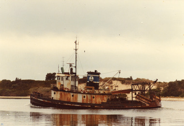
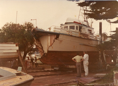 Lakes Entrance Regional Historical Society (operating as Lakes Entrance History Centre & Museum)
Photograph, 1970c
... Waterways ...Owner, Owen Allan of EdenColour photograph of the fishing boat Richard Allan on slips, having sustained serious damage to the bow section after collision with oil rig supply boat. Lakes Entrance Victoriafishing industry, ships and shipping, waterways -
 Lakes Entrance Regional Historical Society (operating as Lakes Entrance History Centre & Museum)
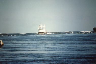
Photograph, Fraser, Ian, 1989c
... Waterways ...Colour photograph of the fishing vessel James Kerlin entering the lake from Bass Strait. On right of image is the end of western pier, behind James Kerlin surf is breaking on bar, in foreground calm entrance channel. Lakes Entrance Victoriafishing industry, ships and shipping, waterways -
 Lakes Entrance Regional Historical Society (operating as Lakes Entrance History Centre & Museum)
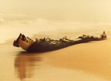
Photograph, Bryce, Anne, 1981
... Waterways ...Date made 13 August 1981Colour photograph showing Keith Bryce inspecting the remains of the wrecked St John Star which became stranded in fog fourteen kilometres east of Lake Tyers, near Lakes Entrance, Victoria.fishing industry, ships and shipping, waterways -
 Lakes Entrance Regional Historical Society (operating as Lakes Entrance History Centre & Museum)
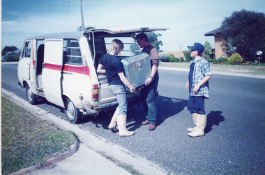
Photograph, Bennett, Vera, 1992
... Waterways ...A second colour photo show three men loading the sounder into the back of a van for relocation (donated to LERHS)Colour photograph of the Anti Submarine Detection Investigation Committee Sounder, which Kevin and Frank Mitchelson installed in fishing boat Massbanker in 1968, to locate shoals of fish. Lakes Entrance Victoriaboats and boating, fishing industry, waterways -
 Lakes Entrance Regional Historical Society (operating as Lakes Entrance History Centre & Museum)
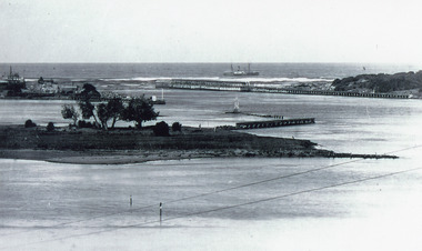
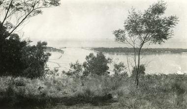
Photograph, 1915c
... Waterways ...On back of original 'To Rit with love from Arthur' (Arthur Seagrove - Head Teacher, Johnsonville Primary School - 1920)Black and white photograph of Bullock Island and the man-made entrance from Bass Strait. It shows the Western end of Bullock Island, some natural vegetation, jetty and timber groynes, trading vessel standing outside entrance. Lakes Entrance Victoriawaterways, islands, topography -
 Lakes Entrance Regional Historical Society (operating as Lakes Entrance History Centre & Museum)
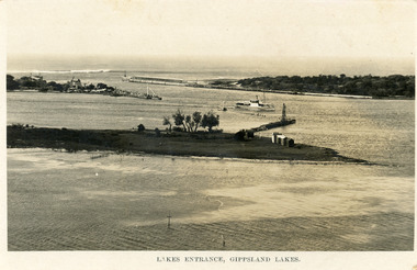
Postcard, Bulmer H D, 1923c
... Waterways ...Also same image|Faded copy 10x15|Black and White 12x17.5|Black and White 20x28.5Black and white postcard of the entrance to the Gippsland Lakes, showing buildings at New Works, cranes on ends of piers, jetty and bathing boxes on bullock Island, steamer passing island. Lakes Entrance VictoriaLakes Entrance, Gippsland Lakeswaterways, islands, topography -
 Lakes Entrance Regional Historical Society (operating as Lakes Entrance History Centre & Museum)
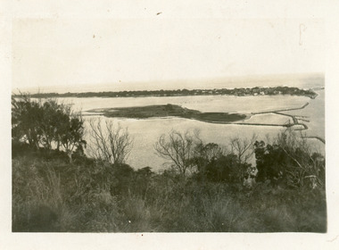
Photograph, 1925c
... Waterways ...Black and white photograph of Bullock Island, the entrance from Bass Strait to the Gippsland Lakes, the hummocks at the south shore of the lakes. Bathing boxes on Bullock Island. Lakes Entrance Victoriawaterways, islands, houses -
 Lakes Entrance Regional Historical Society (operating as Lakes Entrance History Centre & Museum)
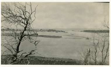
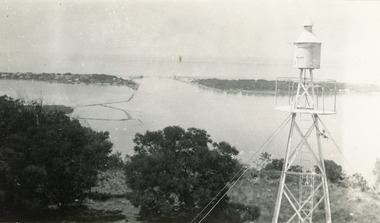
Photograph, 1930c
... Waterways ...Black and white photograph of Bullock Island, showing the footbridge to the island, the rock groynes at the western end of the island, built to direct flood and tide waters to entrance. Photo taken from Kalimna Hill, scub in foreground. Lakes Entrance Victoriawaterways, islands, township -
 Lakes Entrance Regional Historical Society (operating as Lakes Entrance History Centre & Museum)
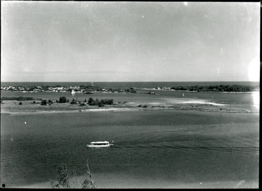
Photograph, Silver Reflections Studio, 1920c
... Waterways ...Black and white photograph showing Bullock Island, Entrance to Bass Strait, buildings on sand dunes, yacht sailing on Cunninghame Arm, tourist launch in foreground, rock groynes around west end of Bullock Island. Lakes Entrance Victoriawaterways, education, room display -
 Lakes Entrance Regional Historical Society (operating as Lakes Entrance History Centre & Museum)
Photograph, Holding George, 1975c
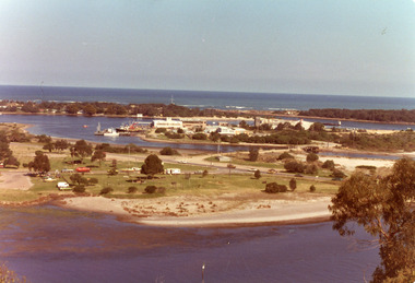
... Waterways ...Colour photograph of Bullock Island showing Pecks fish processing factory Lakes Entrance Fishing Co-Operative, and PWD buildings, vehicles on picnic area of Marine Parade during one and only offshore power boat race. Spit opposite Club Hotel has grass and some bushes. Lakes Entrance Victoriaislands, land reclamation, waterways -
 Lakes Entrance Regional Historical Society (operating as Lakes Entrance History Centre & Museum)
Photograph, Fish Marie, 1995c
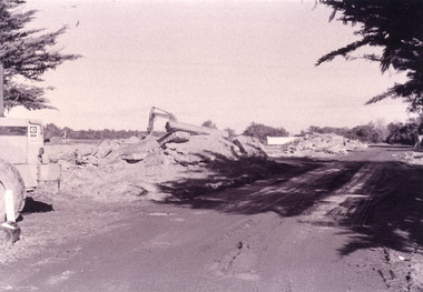
... Waterways ...Black and white photograph, heavy machinery clearing the site of Pecks fish processing factory on Bullock Island, showing piles of broken concrete ready for removal. Lakes Entrance Victoriaislands, waterways, topography -
 Lakes Entrance Regional Historical Society (operating as Lakes Entrance History Centre & Museum)
Photograph, Fish Marie, 2005c
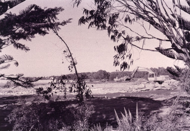
... Waterways ...Black and white photograph showing heavy machinery clearing the site of Pecks fish processing factory on Bullock Island, photo also shows dumped sand on island and Kalimna Heights in background. Lakes Entrance Victoriaislands, waterways, topography -
 Lakes Entrance Regional Historical Society (operating as Lakes Entrance History Centre & Museum)
Photograph, Lakes Post Newspaper, 1996
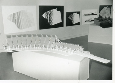
... Waterways ...Date made February 1996Black and white photograph of the exhibition of designs for the proposed Gondwanaland Education Centre on Bullock. It shows architectural drawings and a model of the building. Lakes Entrance Victoriaislands, education, waterways -
 Lakes Entrance Regional Historical Society (operating as Lakes Entrance History Centre & Museum)
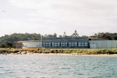
Photograph, 2005
... Waterways ...Date made September 2005Colour photograph of the RMIT TAFE Educational Facility on Bullock Island, taken from Cunninghame Arm. In the background is the navigation lights on Jemmys Point and residence on Kalimna Heights. Lakes Entrance Victoriaislands, education, waterways -
 Lakes Entrance Regional Historical Society (operating as Lakes Entrance History Centre & Museum)
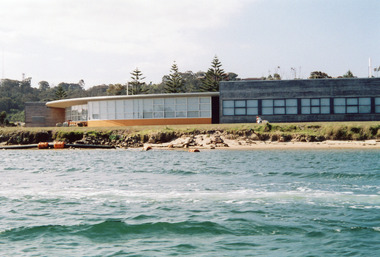
Photograph, 2005
... Waterways ...Date made September 2005Colour photograph of the RMIT TAFE Educational Facility on Bullock Island, taken from Cunninghame Arm, in the back ground are communication towers on Kalimna Heights. The Kalimna escarpment contrasts with the low lying sand formation of Bullock Island. Lakes Entrance Victoriaislands, education, waterways -
 Lakes Entrance Regional Historical Society (operating as Lakes Entrance History Centre & Museum)
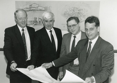
Photograph, 1991
... Waterways ...Date made September 1991Black and white photograph of signatories to the Major Projects Unit - Bullock Island agreement, September 1991, Lakes Entrance, Victoria.islands, waterways, land reclamation -
 Lakes Entrance Regional Historical Society (operating as Lakes Entrance History Centre & Museum)
Postcard, 1940c
... Waterways ...Also one similar images, 7 x 12.5, donated by Pam Cole, Lara VicBlack and white postcard of Bullock Island, and rock groynes, Reeves and Entrance Channels and Carpenter Town at the New Works, taken from Jemmys Point, dense vegetation in foreground. Lakes Entrance VictoriaThe Entrance Lakes Entrancetownship, waterways, topography -
 Lakes Entrance Regional Historical Society (operating as Lakes Entrance History Centre & Museum)
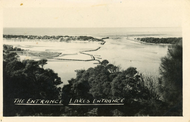
Postcard, 1940c
... Waterways ...Black and white postcard of Bullock IslandThe Entrance Lakes Entrancetownship, waterways, topography -
 Lakes Entrance Regional Historical Society (operating as Lakes Entrance History Centre & Museum)
Postcard, 1940c
... Waterways ...Black and white postcard of Bullock IslandThe Entrance Lakes Entrancetownship, waterways, topography