Showing 126749 items
matching main-road
-
 Stawell Historical Society Inc
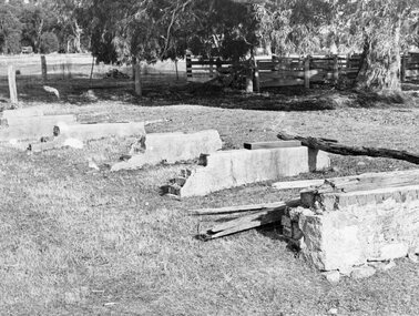
Photograph, Brick remains of the Tannery of Mr C Whel off Halls Gap Road Stawell West behind the London Hotel 1982
Brick remains of Tannery run by C Whel off Halls Gap Road Stawell West behind the London Hotel 1982stawell industry -
 The Beechworth Burke Museum Research Collection
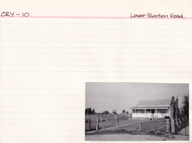
Card (Series) - Index Card, George Tibbits, Lower Everton Road, Beechworth, 1976
George Tibbits, University of Melbourne. Faculty of Architecture, Building and Town & Regional PlanningIndex system that support the research for Beechworth : historical reconstruction / [by] George Tibbits ... [et al]Arranged by street names of BeechworthEach index card includes: street name and number of property, image of property, allotment and section number, property owners and dates of ownership, description of the property according to rate records, property floor plan with dimensions.beechworth, george tibbitsbeechworth, george tibbits -
 Greensborough Historical Society
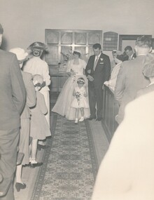
Photograph - Digital Image, Partington Family, Wedding of Faye Partington and Eric Fort 1957, 1957_
The marriage of Faye Partington to Eric Fort at the Greensborough Methodist Church; Main Street; 1957. Faye and Eric Fort leave the Church with flower girl Karin Anderson.One of a series of Partington wedding photographs taken at the old Methodist Church.Digital copy of black and white photographpartington family, faye fort (nee partington), eric fort -
 Ringwood and District Historical Society
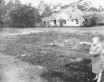
Photograph, Mrs. E.V. Pullin, Chairman Library Promotion Committee pointing to new library site - 1967 - opposite Eastland and the bowling green, Warrandyte Road. Five photographs
Mrs. E.V. Pullin, Chairman Library Promotion Committee pointing to library site - 1967 - opposite Eastland and the bowling green, Warrandyte Road. House on the library site was demolished at the end of 1968 and the library opened on 2nd May 1970. -
 Ringwood and District Historical Society
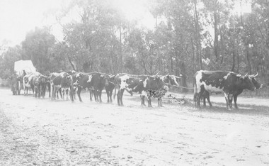
Photograph, Bullock team in Bedford Road opposite later site of Ringwood High School. c.1890
Typed below photograph, "Bedford Road, opposite present High School about 1890". Another copy dates the photograph as 1923 and another copy states on the backing sheet, "Hussey of South Warrandyte, 1924. Used in and around Ringwood". -
 Ringwood and District Historical Society
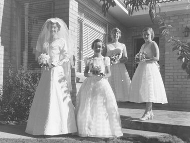
Photograph, Wedding. Miss N. Williams - Mr. G.A. Oddie, Whitehorse Road, Ringwood. Married at Trinity College Chapel
Catalogue card reads, 'Wedding. Miss N. Williams - Mr. G.A. Oddie, Whitehorse Road, Ringwood. Married at Trinity College Chapel, December 14th [no date]'. Written on back of photograph, 'Photo by Peter Payens, Ringwood Studios'. -
 Whitehorse Historical Society Inc.
Photograph, Mitcham Memorial Hall
The Memorial Hall on Mitcham Road Mitcham, opened officially on Sunday 13 June 1926. The RSL used the hall until 1951, when it was sold to the Nunawading Council to be used as a community facility. In 1993 Nunawading Council sold the hall site.Three coloured photographs a-c of the Mitcham Memorial Hall (demolished). The statue of the soldiers in the foreground has been removed to Halliday Park, Mitcham. Whitehorse Road is in the foreground of each photograph.mitcham memorial hall -
 Ballarat Tramway Museum
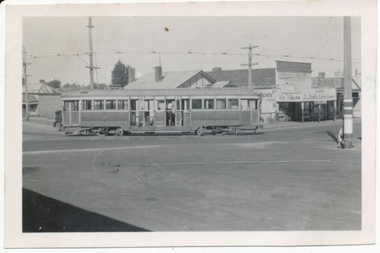
Photograph - Digital image, Ken Magor, 28/12/1950 12:00:00 AM
Yields information about the early use of Ballarat's bogie trams and the curve from Main Rd into Barkly St on the Mt Pleasant route.Digital image from the Wal Jack Ballarat Album of Ballarat 35 turning from Barkly St Mount Pleasant route into Main Road, 28-12-1950. Photo by Ken Magor. Shows the shops behind the tram - Milk bar - diary - advertising ice cream, Robur tea, fruits and confectionery. See image i2 for rear of photograph.On rear in ink "No. 35 from Mount Pleasant turning out of Barkly St into Main Street 28-12-50" and Ken Magor stamp with Neg No. "1901" written in.trams, tramways, mt pleasant, barkly st, main road, tram 35 -
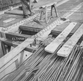 Eltham District Historical Society Inc
Album - Photograph, J.A. McDonald, General; Albion Street and Eltham-Yarra Glen Road, Oct. 1955
General – Country Roads Board Albion Street bridge over Moonee Ponds Creek, Brunswick West Deck Forms October 1955Record of various Shire of Eltham infrastructure works undertaken during the period of 1952-1962 involving bridge and road reconstruction projects, sometimes with Eltham Shire Council Project Reference numbers quoted. It was during this period that a number of significant improvements were made to roads and new bridges constructed within the shire that remain in place as of present day (2022). In many situations, the photos provide a tangible visible record of infrastructure that existed throughout the early days of the Shire. The album was put together by or under the direction of the Shire Engineer, J.A. McDonald.infrastructure, road construction, shire of eltham, 1955-10, albion street, bridge construction, country roads board, benchmark studies, brunswick west, moonee ponds creek -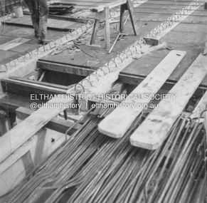
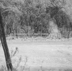 Eltham District Historical Society Inc
Album - Photograph, J.A. McDonald, Heidelberg-Kinglake Road, May 1957
Showing where A – S utility went over between Ninks Road and Cooksons Hill – May 1957 Smoke from burning carRecord of various Shire of Eltham infrastructure works undertaken during the period of 1952-1962 involving bridge and road reconstruction projects, sometimes with Eltham Shire Council Project Reference numbers quoted. It was during this period that a number of significant improvements were made to roads and new bridges constructed within the shire that remain in place as of present day (2022). In many situations, the photos provide a tangible visible record of infrastructure that existed throughout the early days of the Shire. The album was put together by or under the direction of the Shire Engineer, J.A. McDonald.infrastructure, shire of eltham, bridge construction, heidelberg-kinglake road, road construction, 1957-05 -
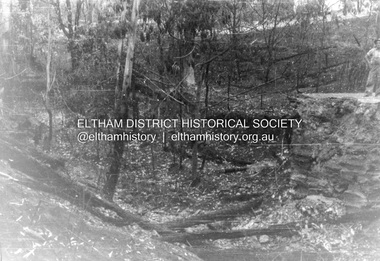 Eltham District Historical Society Inc
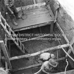
Album - Photograph, J.A. McDonald, Salters Rush Road, Smiths Gully, Aug. 1962
Salters Rush Road, Smiths Gully Bridge over Salters Rush Creek following bush fires 15-16 Jan. 1962Record of various Shire of Eltham infrastructure works undertaken during the period of 1952-1962 involving bridge and road reconstruction projects, sometimes with Eltham Shire Council Project Reference numbers quoted. It was during this period that a number of significant improvements were made to roads and new bridges constructed within the shire that remain in place as of present day (2022). In many situations, the photos provide a tangible visible record of infrastructure that existed throughout the early days of the Shire. The album was put together by or under the direction of the Shire Engineer, J.A. McDonald.H941 stamped on reverse (film processing #)infrastructure, shire of eltham, bridge construction, road construction, 1962-08, bushfires, salters rush road, smiths gully, victorian bushfires - 1962 -
 Eltham District Historical Society Inc
Negative - Photograph, J.A. McDonald, Heidelberg-Kinglake Road, Sep 1959
Job 56M430 Contractor Hone Heavy rain washed out the east abutment and access road to house 19-20 September 1959Record of various Shire of Eltham infrastructure works undertaken during the period of 1952-1962 involving bridge and road reconstruction projects, sometimes with Eltham Shire Council Project Reference numbers quoted. It was during this period that a number of significant improvements were made to roads and new bridges constructed within the shire that remain in place as of present day (2022). In many situations, the photos provide a tangible visible record of infrastructure that existed throughout the early days of the Shire. The album was put together by or under the direction of the Shire Engineer, J.A. McDonald.infrastructure, shire of eltham, bridge construction, 1959-09, heidelberg-kinglake road, road construction -
 Eltham District Historical Society Inc
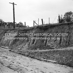
Negative - Photograph, J.A. McDonald, Henley Road at Watsons Creek, Apr. 1961
Henley Road at Watsons Creek showing excavation at western pier Rock at contract level, slight underground flow Early April 1961Record of various Shire of Eltham infrastructure works undertaken during the period of 1952-1962 involving bridge and road reconstruction projects, sometimes with Eltham Shire Council Project Reference numbers quoted. It was during this period that a number of significant improvements were made to roads and new bridges constructed within the shire that remain in place as of present day (2022). In many situations, the photos provide a tangible visible record of infrastructure that existed throughout the early days of the Shire. The album was put together by or under the direction of the Shire Engineer, J.A. McDonald.infrastructure, shire of eltham, bend of islands, cr. charis pelling, henley road, henley road bridge, kangaroo ground, oxley bridge, watsons creek, w.e. wolf, bridge construction, road construction, 1961-04 -
 Eltham District Historical Society Inc
Photograph, Baldwin Avenue, Montmorency viewed from Sherbourne Road, 13 November 2019, 13/11/2019
Ref: EDHS_03875 (1972) and EDHS_04774-4 (2019) from opposite ends showing realignment of road at intersection of Sherbourne and the same Cypress treeBorn digitalbaldwin avenue, montmorency, sherbourne road, gardens, landscaping -
 Greensborough Historical Society
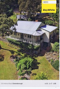
Advertising Leaflet, Diamond Valley Leader, 3 St Helena Road Greensborough, 15/11/2017
Auction brochure and newspaper advertisement for 3 St Helena Road Greensborough, auction on 9 December 2017. Former owner: Dr. Woods4 p. col. laminated brochure, with advertisement published in Diamond Valley Leader 15 November 2017st helena road greensborough -
 Greensborough Historical Society
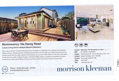
Newspaper Clipping, Domain Review et al, 16a Davey Road Montmorency, 17/11/2018
16a Davey Road Montmorency, 4 bedroom home, sold 17/11/2018 for $1,050,000; previous sales: October 2012 $585,000. Real estate advertising in newspaper, colour imagedavey road montmorency -
 Greensborough Historical Society
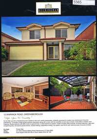
Advertising Leaflet, 12 Warwick Road Greensborough, 08/07/2016
12 Warwick Road Greensborough: 3 bedroom home, private sale, sold November 2012 for $590,000, and 08/07/2016 for $691,000Real estate advertising leaflet, 1 sheet, printed in colour both sideswarwick road greensborough -
 Greensborough Historical Society
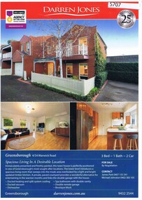
Advertising Leaflet, Darren Jones, 4/54 Warwick Road Greensborough, 25/07/2018
4/54 Warwick Road Greensborough. Three bedroom townhouse, sold for $667,000 in July 2018. Previous sales: October 2012, $420,000.Real estate advertising leaflet, 1 sheet, printed in colour both sides. warwick road greensborough -
 Greensborough Historical Society
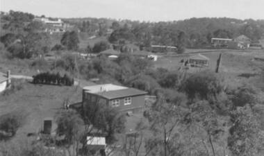
Photograph - Digital image, View of Bicton Street from Gladstone Road, 1950_
This view of Bicton Street Greensborough, taken from Gladstone Road Briar Hill circa 1950 shows the rural nature of the suburb at this time.Digital copy of black and white photo.bicton street greensborough, gladstone road briar hill -
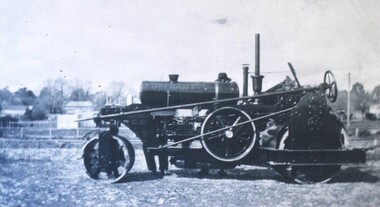 City of Ballarat Libraries
Photograph, Jelbart Road Roller circa 1930s
Jelbart Road Roller property of Northcote Council, circa 1930. This roller was manufactured in Ballarat by Jelbarts, whose foundry was located in Mair Street.jelbart, ballarat, mair street, manufacturing, road roller, northcote, foundry -
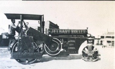 City of Ballarat Libraries
Photograph, Jelbart Road Roller circa 1930s
Jelbart Road Roller property of Northcote Council, circa 1930. This roller was manufactured in Ballarat by Jelbarts, whose foundry was located in Mair Street.jelbart, ballarat, mair street, manufacturing, foundry, northcote, road roller -
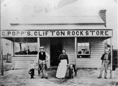 Stawell Historical Society Inc
Photograph, Mr C. Popp’s Clifton Rock Store on the the corner of Newington Road and Sophia Street Stawell
C. Popp’s Clifton Rock Store simple wooden cottage with verandah across front. Located at corner of Newington Road and Sophia Street.stawell -
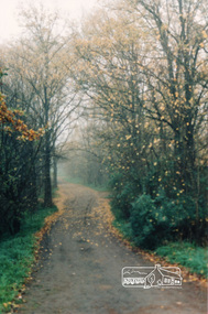 Eltham District Historical Society Inc
Photograph, Diamond Creek Trail, Eltham
Colour photograph of Autumn view of Diamond Creek Trail opposite Dalton Street west of Main Roaddalton street, walkways -
 Eltham District Historical Society Inc
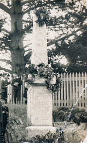
Photograph, Eltham War Memorial
Unveiled by Lieut. Governor Sir William Irvine, 3 August 1919 at 3:30 p.m.Postcard image of First World War Memorial (obelisk) cnr. Main Road and Bridge Street, ElthamOriginal inscriptions obscured by large paper label stuck to rear for Nillumbik Mail publication details, Edition 26, 25 Octobermemorials, war memorials, main road, bridge street, eltham -
 Eltham District Historical Society Inc
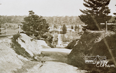
Photograph, Eltham (Bridge Street)
Colour photograph of an original sepia image of Bridge Street, Eltham looking west from Main Roadeltham, bridge street, main road -
 Eltham District Historical Society Inc
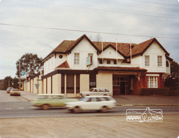
Photograph, Peter Bassett-Smith, Eltham Hotel, Eltham, June 1977, 1977
Colour photograph of Eltham Hotel viewed from opposite on Main Road looking up Pitt Streeteltham, eltham hotel, main road, pitt street, hotels -
 Victorian Interpretive Projects Inc.
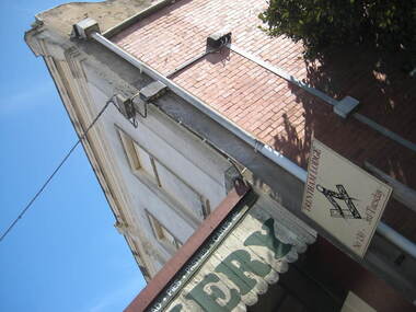
Photograph - colour, Clare Gervasoni, Trentham Masonic Lodge, 2012
Photograph of the first floor of a brick shop in the Main Road of Trentham. The first floor is the Trentham Masonic Lodge.trentham, freemason, trentham masonic lodge, masonic lodge -
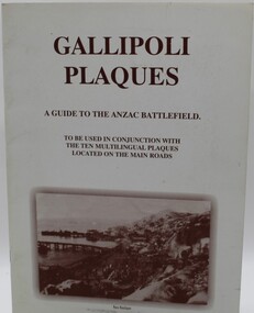 Ringwood RSL Sub-Branch
Book, Gallipoli Plaques, 2000
Soft cover. A guide to the ANZAC battlefield. To be used in conjunction with the ten multilingual plaques located on the main roads. -
 Ringwood and District Historical Society
Programme, Jenkin and Buxton and Co., Rialto, East Ringwood Swimming Pool (Dublin Road) - Aquatic Carnival Programme 1924, 8-Mar-24
Programme for the first grand Aquatic Carnival Picnic Saturday 8-Mar-1924 in the Dublin Road new swimming pool, East Ringwood, under the auspices of the Victorian Swimming Association.; Blue covered, black printing, 8 pages of printed programme for the Victorian Amateur Swimming Association.