Showing 8265 items matching "north warrandyte"
-
 Ringwood and District Historical Society
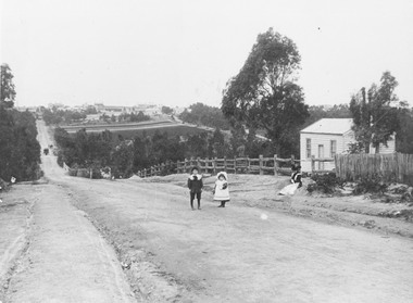
Photograph, Addison home 1902 Ringwood in background
... Ringwood and District Historical Society 125A Warrandyte ...Black and white photograph of scene showing unmade road with two children, a boy and a girl standing outside a small wooden building. Lady is sitting by the side of road. Road dips down to a bridge then rises again towards distant settlement in background. (3 copies)Typed below enlarged photo, "Addison home, 1902 - Opposite present St. Paul's, Warrandyte Road". Written on backing sheet, "Andersons Creek Rd. 1903. Mrs. Addison (Annie Kennedy) and family - Annie, born 1897 and William. Their house at right was on a 5 acre block. Ringwood in background". Backing sheet of another copy reads, "Andersons Creek Road 1902 (Warrandyte Rd. looking south). Mrs. Addison (Annie Kennedy) and family. Annie (Jnr), born 1897 and Samuel John James William, born 1894. Their home, at right, was on a 5 acre block. Ringwood in background - burned down by pet magpie. T. Grant's land ploughed - now Eastland. Adelaide St. seen on right of it. Mullum Creek Bridge at foot of hill". Typed below this photograph, "Warrandyte Rd. Ringwood looking south from near Mullum Rd. Ringwood in background. Maroondah Highway at top of hill with Mullum Creek bridge seen in dip - 1902". -
 Ringwood and District Historical Society
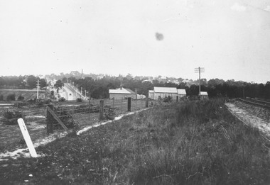
Photograph, Looking along railway line from Ringwood station.Circa 1910
... Ringwood and District Historical Society 125A Warrandyte ...Typed below photograph, "Looking along railway line from Ringwood station. Club Hotel can be seen above roof of church. Maroondah Hwy on left. Circa 1910". -
 Ringwood and District Historical Society
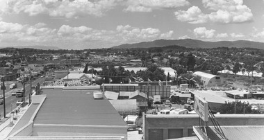
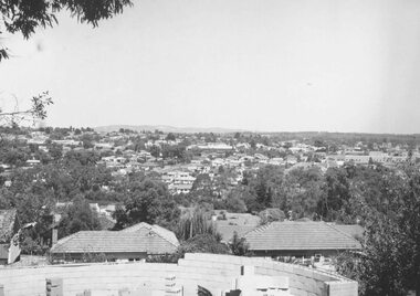
Photograph, Ringwood from top of S.E.C. pylon - 1973
... Ringwood and District Historical Society 125A Warrandyte ...Typed below photograph, "Ringwood from top of S.E.C. pylon - 1973". -
 Ringwood and District Historical Society
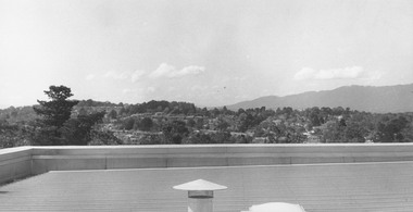
Photograph, View from Civic Centre roof - September 1973
... Ringwood and District Historical Society 125A Warrandyte ...Written on backing sheet, "From Civic Centre roof - September 1973". -
 Ringwood and District Historical Society
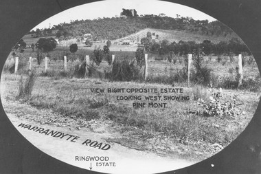
Photograph, View from Warrandyte Road opposite Ringwood Estate looking west, showing Pine Mont. (no date)
... Ringwood and District Historical Society 125A Warrandyte ...Printed onto photograph, "View right opposite estate looking west, showing Pine Mont". Roadway identified as "Warrandyte Road" and "Ringwood Estate" printed at bottom of picture. -
 Ringwood and District Historical Society
Photograph, Herman Pump's orchard and home Heathmont - 1923 - in vicinity of Royal Avenue. House on Canterbury Road, later site of Uniting Church
... Ringwood and District Historical Society 125A Warrandyte ...Black and white photograph of orchard. House in top left of photograph.Typed on backing sheet below photograph, "Herman Pump's orchard and home Heathmont - 1923 - in vicinity of Royal Avenue. House on Canterbury Road, now site of Uniting Church". -
 Ringwood and District Historical Society
Photograph, View from Colemans Estate Heathmont, 1923. Near corner of Bedford and Canterbury Roads
... Ringwood and District Historical Society 125A Warrandyte ...Typed below photograph, "View from Colemans Estate Heathmont, 1923. Near corner of Bedford and Canterbury Roads". -
 Ringwood and District Historical Society
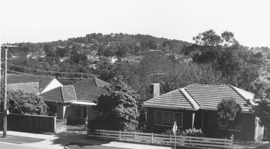
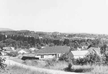
Photograph, View over Ringwood from Mullum Road, 1960
... Ringwood and District Historical Society 125A Warrandyte ...Typed below photograph, "View over Ringwood from Mullum Road, 1960" but small original photograph states photograph was taken in 1959. -
 Ringwood and District Historical Society
Photograph, View from Civic Centre, Braeside Avenue, overlooking Maroondah Highway towards Loughnan's Hill - 1973
... Ringwood and District Historical Society 125A Warrandyte ...Black and white photograph looking towards T-intersection towards housing and trees on hill. -
 Ringwood and District Historical Society
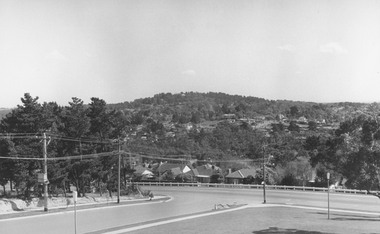
Photograph, View from Maroondah Highway opposite Braeside Avenue towards Loughnan's Hill - 1973
... Ringwood and District Historical Society 125A Warrandyte ...View from Maroondah Highway opposite Braeside Avenue towards Loughnan's Hill - 1973. -
 Ringwood and District Historical Society
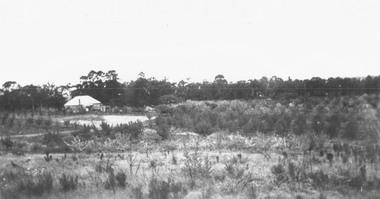
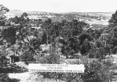
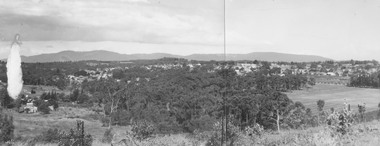
Photograph, Two images of view from Pinemont Estate, Loughnans Hill, looking east, c1930
... Ringwood and District Historical Society 125A Warrandyte ...Black and white photograph of view. Trees and bushes in foreground, orchards and mountains towards background. (2 copies)Typed on photograph, "Pinemont Estate, Ringwood. View Dandenong Ranges, from estate". Typed below photograph, "View from Loughnans Hill, looking east, c1930. Club Hotel can just be seen top right corner". -
 Ringwood and District Historical Society
Photograph, Rear of Jack Williams' orchard, Mullum Road - 1964
... Ringwood and District Historical Society 125A Warrandyte ...Written on backing sheet, "Rear Jack Williams' orchard, Mullum Road - 1964". -
 Ringwood and District Historical Society
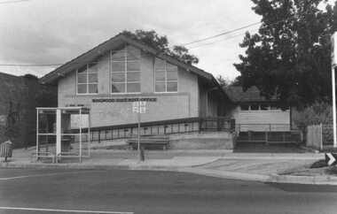
Photograph, East Ringwood Post Office, 1986
... Ringwood and District Historical Society 125A Warrandyte ...Written on back of photograph, "East Ringwood Post Office, 1986". -
 Ringwood and District Historical Society
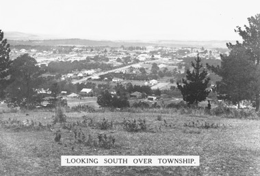
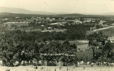
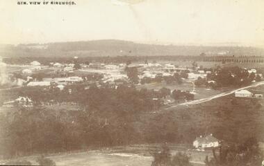
Photograph, Looking south over Ringwood township from Loughnans Hill c1930. Ringwood Street is the main road in the centre
... Ringwood and District Historical Society 125A Warrandyte ...Black and white photograph taken from hill overlooking township of Ringwood. (3 copies)Printed on photograph, "Looking south over township". Typed below photograph, "View from Loughnans Hill c1930. Ringwood Street is the main road in the centre. Old St. Pauls, railway crossing, Methodist church, state school, coolstores, etc. can all be seen". -
 Ringwood and District Historical Society
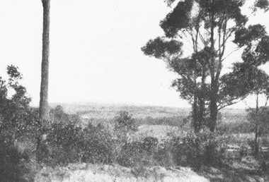
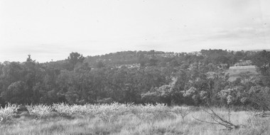
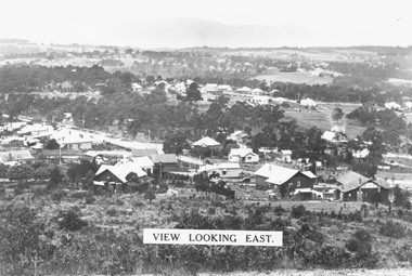
Photograph, View from Loughnan's Hill looking east c1930
... Ringwood and District Historical Society 125A Warrandyte ...Black and white photograph taken from vacant land on hill. Scene overlooks housing and trees. Mountains in background. (2 copies)Typed on photograph, "View looking east". Typed below photograph, "View from Loughnans Hill c1930. Maroondah Highway, Catholic church all top right corner". -
 Ringwood and District Historical Society
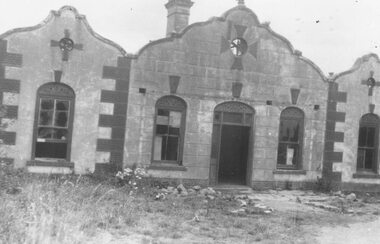
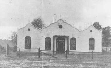
Photograph, The Rest" tea rooms, Maroondah Highway, opposite Heatherdale Road
... Ringwood and District Historical Society 125A Warrandyte ...Black and white photograph of old brick building with scalloped roof-line. Decorative bricks in various places, particularly on top of windows and door.'The Rest' tea rooms, Maroondah Highway, opposite Heatherdale Road. -
 Ringwood and District Historical Society
Photograph, Overlooking Ringwood from Loughnans Hill showing the antimony mine and brick works c.1914
... Ringwood and District Historical Society 125A Warrandyte ...Two postcards, same view but different reverse sides. One was made by "Empire" with a 1d postage (see description below); the other with "JB McAlpin, Estate and Financial Agent, District Government Valuer, Ringwood". A letter on one of the postcards is dated 1914 and is addressed to "Mrs. F. Palmer, c/- Mrs. E. F. Tregaskis, White Horse Road, Ringwood, via Melbourne". The letter is to her mother and the daughter's name is "Eveline". The following is written on the back of one of the enlargements, "View of Ringwood East taken from Loughnans Hill showing the antimony mine and brick works. Houses across centre are in Warrandyte Road. -
 Ringwood and District Historical Society
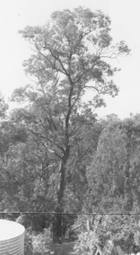
Photograph, Red box tree at rear of 39 Burlock Avenue (no date)
... Ringwood and District Historical Society 125A Warrandyte ...Written on back of photograph, "Paul's shot of the big box tree from the top of the shed". Also, "Red box tree at rear of 39 Burlock Avenue". -
 Ringwood and District Historical Society
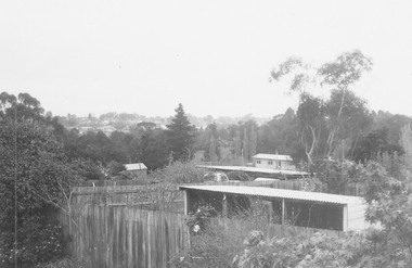
Photograph, Panoramic view of Ringwood taken from the home of Dr. Geoffrey A. Cook, Loughnan Rd., Ringwood. (No date)
... Ringwood and District Historical Society 125A Warrandyte ...Written on back of photograph, "Panoramic view of Ringwood taken from the home of Dr. Geoffrey A. Cook, Loughnan Rd., Ringwood. See booklet, 'Welcome to Ringwood' 1948 or 49' - H.J. Pearson Mayor". -
 Ringwood and District Historical Society
Photograph, 'The Rest' tea rooms at west entrance to Ringwood c1900s-1950
... Ringwood and District Historical Society 125A Warrandyte ...Written on back of photograph, "Top of hill at west entrance to Rwd. 1900s - 1950. 1950 pulled down - Eastland." -
 Ringwood and District Historical Society
Photograph, View of Ringwood in 1912 taken from Loughnan's Hill
... Ringwood and District Historical Society 125A Warrandyte ...Black and white photograph looking across valley with small settlement. Mountains in background. (2 postcard copies and 2 enlargements). House in right foreground is in what is known now as Wildwood Grove. The dirt track above is Ringwood St. Field above is the football field with diagonal track coming out at Melbourne Street, later Eastland shopping complex. House on left is in Adelaide Street. Warrandyte Road is above it."Typed on back of one enlargement, "Copied from a postcard mailed in Ringwood, 1912, copied 1959. House in right foreground is in what is known now as Wildwood Grove. The dirt track above is Ringwood St. Field above is the present football field with diagonal track coming out at Melbourne Street. House on left is in Adelaide Street. Warrandyte Road is above it." House bottom RH side was still there in 1970 in Wildwood Grove (off Ringwood St). Ringwood Street lower centre to RH side. Field above Ringwood Street is the football field with diag. walk coming out at Melbourne Street. House on LH side in Adelaide Street. Warrandyte above it. Steam at LH from Bently's Steam Joinery at corner Main Street and Warrandyte Road. -
 Ringwood and District Historical Society
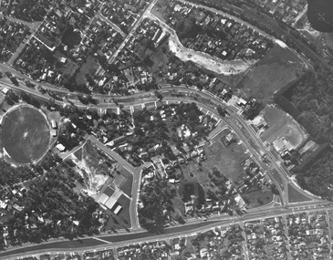
Photograph, Aerial view showing East Ringwood oval, Mount Dandenong Road, and Civic Centre, Braeside Avenue/Maroondah Hwy, c.1970
... Ringwood and District Historical Society 125A Warrandyte ...Aerial view showing East Ringwood oval, Mount Dandenong Road, and Civic Centre, Braeside Avenue/Maroondah Hwy, c.1970. -
 Ringwood and District Historical Society
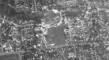
Photograph, Aerial view showing Mullum Ovals 1 and 2, Mullum Road. c.1970
... Ringwood and District Historical Society 125A Warrandyte ...Aerial view showing Mullum Ovals 1 and 2, Mullum Road. c.1970. -
 Ringwood and District Historical Society
Photograph, Ringwood from Loughnans Road, 1960. Round house being built. Looking slightly west
... Ringwood and District Historical Society 125A Warrandyte ...Written on back of photographs, "Ringwood from Loughnans Road, 1960. Round house being built. Looking slightly west". -
 Ringwood and District Historical Society
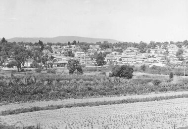
Photograph, Ringwood East looking from corner Warrandyte Road and Wonga Road, 1960
... Ringwood and District Historical Society 125A Warrandyte ...Written on back of photograph, "Ringwood East looking from corner Warrandyte Road and Wonga Road, 1960". -
 Ringwood and District Historical Society
Photograph, Civic Centre, Ringwood, 1970
... Ringwood and District Historical Society 125A Warrandyte ...Written on back of photograph, "Civic Centre, Ringwood, 1970" and "Mt. Dandenong Road just widened". -
 Ringwood and District Historical Society
Photograph, New housing developments, New Street, 1960 viewed from railway line near Madden Street looking south-east
... Ringwood and District Historical Society 125A Warrandyte ...Written on back of photograph, "New housing settlement New Street, 1960. From railway line near Madden Street looking south-east. Dam centre foreground". -
 Ringwood and District Historical Society
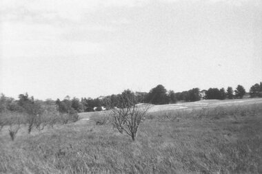
Photograph, Looking across remains of Frazer's orchard to state school, 1972
... Ringwood and District Historical Society 125A Warrandyte ...Updated Information from Bruce Frazer: This is Frazer's (not "Fraser") orchard, sold to A.V. Jennings Co. For housing development c1970. Address was "Alkoomi", Oban Rd. North Ringwood. State School 4120 was enclosed on its north & east sides by the orchard. Owned by Harold & Sylvia Frazer, 12 acres, growing mainly cherries plus plums & lemons. Photo was taken from neighbouring apple orchard (Williams) & shows street construction in the middle distance.Written on back of photograph, "Looking across remains of Fraser's orchard to state school, 1972". -
 Ringwood and District Historical Society
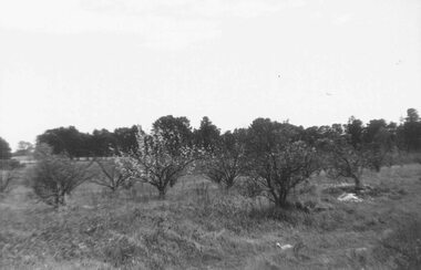
Photograph, Remains of Frazer's orchard, North Ringwood. State school on left - 1972
... Ringwood and District Historical Society 125A Warrandyte ...Updated Information from Bruce Frazer: This is Frazer's (not "Fraser") orchard, sold to A.V. Jennings Co. For housing development c1970. Address was "Alkoomi", Oban Rd. North Ringwood. State School 4120 was enclosed on its north & east sides by the orchard. Owned by Harold & Sylvia Frazer, 12 acres, growing mainly cherries plus plums & lemons. Photo was taken from neighbouring apple orchard (Williams) & shows street construction in the middle distance.Written on back of photograph, "Remains of [Fraser's] orchard. State school on left". -
 Ringwood and District Historical Society
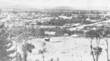
Photograph, A panorama of Ringwood from Mountain View Estate, Loughnan's Hill. (no date)
... Ringwood and District Historical Society 125A Warrandyte ...Typed below photograph, "A Panorama of Ringwood" and written on back of photograph, "Mountain View estate circular".