Showing 126739 items
matching main-road
-
 Melbourne Tram Museum
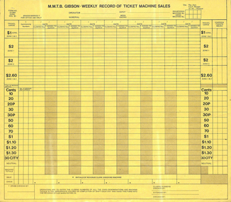
Document - Form/s, Melbourne & Metropolitan Tramways Board (MMTB), "MMTB Gibson Weekly Road of ticket machine sales", Dec. 1981
Printed form on yellow sheet titled "MMTB Gibson Weekly Road of ticket machine sales". Has space for employee name, days, tickets issue, and various values of travel cards and ticket books. Used for Doncaster depot. Form No. 3/139A DONC Dec '81trams, tramways, mmtb, passengers, tickets, forms, revenue journal, buses -
 Melbourne Tram Museum
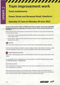
Pamphlet, Yarra Trams, "Tram Improvement work - Power Street and Burwood Road Hawthorn", Jun. 2015
Pamphlet, A4, full colour printed on gloss paper titled "Tram Improvement work - Power Street and Burwood Road Hawthorn" - Saturday 27 June to Monday 29 June 2015/ Gives notes on works, impacts to services and a map along with contact details. 2nd update.trams, tramways, trackwork, power st, burwood rd -
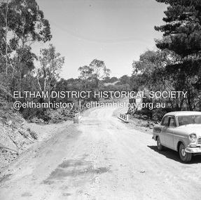
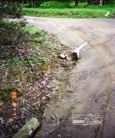
 Eltham District Historical Society Inc
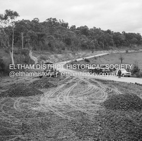
Negative - Photograph, J.A. McDonald, Eltham-Diamond Creek Road, 18 Sep 1959
Bridge construction Eltham-Diamond Creek road over the Diamond Creek (Wattletree Road), Eltham, September 1959 After some delay in receiving funds, work started on the bridge approaches in early September 1959. Traffic was still using the old bridge upstream. On Sunday, 20 September 1959, heavy flooding occurred in the stream and at 3:53 pm the old bridge was washed out. This photo was taken the Friday beforeRecord of various Shire of Eltham infrastructure works undertaken during the period of 1952-1962 involving bridge and road reconstruction projects, sometimes with Eltham Shire Council Project Reference numbers quoted. It was during this period that a number of significant improvements were made to roads and new bridges constructed within the shire that remain in place as of present day (2022). In many situations, the photos provide a tangible visible record of infrastructure that existed throughout the early days of the Shire. The album was put together by or under the direction of the Shire Engineer, J.A. McDonald.infrastructure, shire of eltham, bridge construction, 1959-09-18, bridge, diamond creek (creek), eltham, eltham north, glen park bridge, wattletree road bridge -
 Eltham District Historical Society Inc
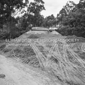
Negative - Photograph, J.A. McDonald, Eltham-Diamond Creek Road, 18 Sep 1959
Bridge construction Eltham-Diamond Creek road over the Diamond Creek (Wattletree Road), Eltham, September 1959 After some delay in receiving funds, work started on the bridge approaches in early September 1959. Traffic was still using the old bridge upstream. On Sunday, 20 September 1959, heavy flooding occurred in the stream and at 3:53 pm the old bridge was washed out. This photo was taken the Friday beforeRecord of various Shire of Eltham infrastructure works undertaken during the period of 1952-1962 involving bridge and road reconstruction projects, sometimes with Eltham Shire Council Project Reference numbers quoted. It was during this period that a number of significant improvements were made to roads and new bridges constructed within the shire that remain in place as of present day (2022). In many situations, the photos provide a tangible visible record of infrastructure that existed throughout the early days of the Shire. The album was put together by or under the direction of the Shire Engineer, J.A. McDonald.infrastructure, shire of eltham, bridge construction, 1959-09-18, bridge, diamond creek (creek), eltham, eltham north, glen park bridge, wattletree road bridge -
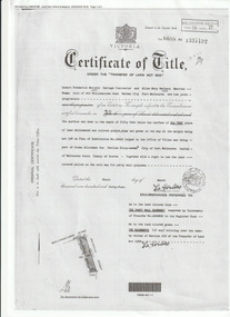 Port Melbourne Historical & Preservation Society
Document (Item), Certificate of Title 400 Williamstown Road, Port Melbourne, 9 Mar 1944
The Certificate of Title states that "Robert Fredrick WATTERS, Cartage Contractor and Ellen Mary WATTERS, Married Woman, both of 400 Williamstown Road, Garden City, Port Melbourne are now Joint Proprietors" of Garden City house & land on the corner of Williamstown and Beacon Roads. in 1963 Ellen became the Surviving Proprietor and 1966 the property passed to Ellen Patricia WATTERS and Norma Madeline WATTERS. Norma was registered as the Surviving Proprietor in 1984. built environment - domestic, garden city, robert fredrick watters, ellen mary watters, ellen patricia watters, norma madeline watters, williamstown road -
 Kew Historical Society Inc
Document - Urban Planning Document, City of Kew, City of Kew : Minimum Size of Allotment Required, 1945-1955
A document outlining the relevant by-laws produced by the City Of Kew to regulate the minimum size of allotments in Barkers Road, Burke Road, Cotham Road, Glenferrie Road and Studley Park Road, as well as in other streets more generally. The by-laws specify the size of allotments in which single unit dwellings, attached houses and maisonettes, and flats could be built. In the ‘main streets’ a minimum land area for single unit dwellings was 8,100 square feet, with an average frontage of 60’ and a depth of 135’. In other streets this was reduced to an overall size of 6,250 square feet, with an average dimensions of 50’ x 125’. In specifying the land area required by flats, different sizes were regulated for the construction of between two and six flats. Six flats at the time when the regulations were passed must have been the upper limit permitted. Understanding the size of land listed in imperial measurements can be a challenge. Within Australia, the so-called quarter acre block was approximately 11,000 square feet. Those specified in the by-laws would appear to be smaller. The document was pasted on the reverse of a subdivision plan in the collection.This is a rare (undated) document produced by the City of Kew defining how subdivision within the municipality should occur. The document was created to constrain unbridled speculation in subdivisions in the various parts of Kew and East Kew.Undated typed document, issued by the City of Kew (1921-1994) indicating the minimum size of allotment required in Barkers Road, Burke Road, Cotham Road, Glenferrie Road and Studley Park Road. The document is mounted on board and waterstained. It was presumably used by a real estate agent. [Formerly catalogued as MAP.0066].city of kew - by-laws and regulations, subdivisions - kew - studley park -
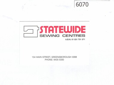 Greensborough Historical Society
Business card and Sales Brochure, Statewide Sewing Centres, 2018_
Statewide Sewing Centre is a franchise selling sewing machines and conducting sewing lessons; this shop has been at the same location for 35 years 104 Main Street GreensboroughBusiness card printed one side in red and black on white; with multi-coloured sales brochuresewing machines, main street greensborough -
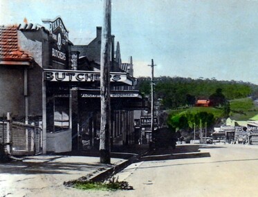 Greensborough Historical Society
Photograph - Digital Image, Greensborough 1940c, 1940c
Photograph taken circa 1940, showing Ryan's Butchers at approximately 69 Main Street Greensborough,.[Street numbers did not come in vogue until the mid 1950's]Digital copy of photographmain street greensborough, ryans butchers -
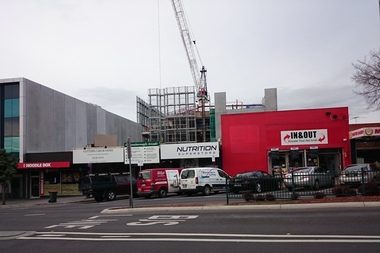 Greensborough Historical Society
Photograph - Digital image, Marilyn Smith, Crane at Watermarc, 19/07/2016
Cranes on the skyline at Watermarc development 2016, taken from Main Street. New Banyule Council offices are being built at 1 Flintoff Street, over the Watermarc building.Digital copy of colour photograph.watermarc, one flintoff, banyule council, main street greensborough -
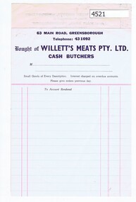 Greensborough Historical Society
Receipt, R. E. Willett Cash Butchers, 1940s
R. & E. Willett butcher shops were at corner Binns and Were Streets, Montmorency and at Main Street, Greensborough. Cash receipts were written before cash registers.Receipt form printed in dark blue and pink ink "Bought of R. & E. Willett, cash butchers"rob willett, main street greensborough, were street montmorency -
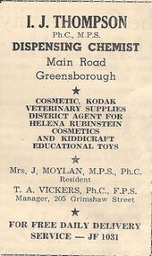 Greensborough Historical Society
Advertisement - Digital image, Thompson Chemist Greensborough, 1950s
These advertisements were collected from the Local newspaper. I.J. Thompson was a Greensborough Chemist shop located at 74 Main Street. At the time of this advertisement, the shop was managed by Tom Vickers.This advertisement is for a Greensborough based shop which no longer operates.Digital copy of newspaper advertisement.thompson chemist greensborough, tom vickers, main street greensborough -
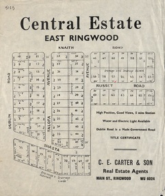 Ringwood and District Historical Society
Flyer, Land Sale Advertisement, Central Estate, East Ringwood - circa 1950
East Ringwood Central Estate auction sale of allotments previously advertised for Saturday October 23rd (1948). Victorian Collections reference 5138 refers.Single sided leafletSubdivision includes Dublin Road, Knaith Road, Talofa Avenue, Russet Road, and Shasta Avenue. Agent - C.E. Carter & Son, Main Street, Ringwood. WU 6024. -
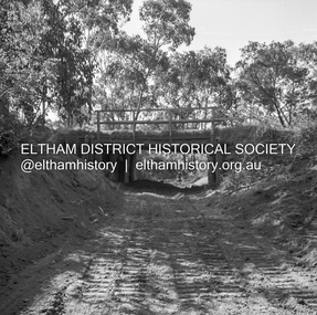
 Eltham District Historical Society Inc
Album - Photograph, J.A. McDonald, General; Albion Street and Eltham-Yarra Glen Road, Oct. 1955
General – Country Roads Board Albion Street bridge over Moonee Ponds Creek, Brunswick West Derrick for launching beams October 1955Record of various Shire of Eltham infrastructure works undertaken during the period of 1952-1962 involving bridge and road reconstruction projects, sometimes with Eltham Shire Council Project Reference numbers quoted. It was during this period that a number of significant improvements were made to roads and new bridges constructed within the shire that remain in place as of present day (2022). In many situations, the photos provide a tangible visible record of infrastructure that existed throughout the early days of the Shire. The album was put together by or under the direction of the Shire Engineer, J.A. McDonald.infrastructure, road construction, shire of eltham, 1955-10, albion street, bridge construction, country roads board, benchmark studies, brunswick west, moonee ponds creek -
 Eltham District Historical Society Inc
Negative - Photograph, J.A. McDonald, Heidelberg-Kinglake Road, Mar. 1960
Cherry Tree Road Job 56F443 Contractors Wolf and Wood Old bridge and stream clearing during construction of new bridge March 1960Record of various Shire of Eltham infrastructure works undertaken during the period of 1952-1962 involving bridge and road reconstruction projects, sometimes with Eltham Shire Council Project Reference numbers quoted. It was during this period that a number of significant improvements were made to roads and new bridges constructed within the shire that remain in place as of present day (2022). In many situations, the photos provide a tangible visible record of infrastructure that existed throughout the early days of the Shire. The album was put together by or under the direction of the Shire Engineer, J.A. McDonald.infrastructure, 1960-03, bridge construction, cherry tree road, heidelberg-kinglake road, road construction, shire of eltham -
 Eltham District Historical Society Inc
Negative - Photograph, J.A. McDonald, Heidelberg-Kinglake Road, Mar. 1960
Job 56M431 ?? ?? bridge and curve improvement to south of Yow Yow Creek March 1960 Contractor W.E. Wolf – Bridge, F.C. Wood - RoadRecord of various Shire of Eltham infrastructure works undertaken during the period of 1952-1962 involving bridge and road reconstruction projects, sometimes with Eltham Shire Council Project Reference numbers quoted. It was during this period that a number of significant improvements were made to roads and new bridges constructed within the shire that remain in place as of present day (2022). In many situations, the photos provide a tangible visible record of infrastructure that existed throughout the early days of the Shire. The album was put together by or under the direction of the Shire Engineer, J.A. McDonald.infrastructure, 1960-03, bridge construction, cherry tree road, heidelberg-kinglake road, road construction, shire of eltham -
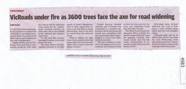 Greensborough Historical Society
Newspaper Clipping, Diamond Valley Leader, VicRoads under fire as 3600 trees face the axe for road widening, 31/05/2017
A Yan Yean Rd community forum member is concerned VicRoads is not being transparent about the removal of 3600 trees as part of plans for the road’s realignment.News article 1 page, black text.yan yean road, vicroads, tree removal, yarrambat -
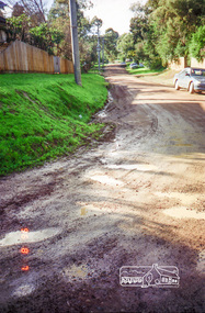
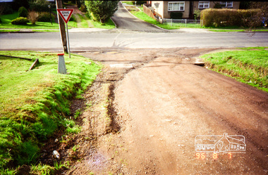
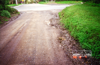
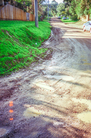 Eltham District Historical Society Inc
Photograph, Road surface conditions around Eltham: Looking east along Franklin Street from intersection with Bible Street, 7 Aug 1996, 1996
Shows sections of Franklin, John and Napoleon streets were still unmade as of late 1996 and the condition of those roads with potholes at the intersections with Bible Street.Reflects on the changing nature of the local street-scape and housesRoll of 35mm colour negative film, 7 stripsKodak Gold 100-5eltham, napoleon street, bible street, franklin street, john street -
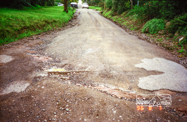
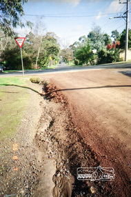 Eltham District Historical Society Inc
Photograph, Road surface conditions around Eltham: Looking west along Franklin Street at intersection with Bible Street, 7 Aug 1996, 1996
Shows sections of Franklin, John and Napoleon streets were still unmade as of late 1996 and the condition of those roads with potholes at the intersections with Bible Street.Reflects on the changing nature of the local street-scape and housesRoll of 35mm colour negative film, 7 stripsKodak Gold 100-5eltham, napoleon street, bible street, franklin street, john street -
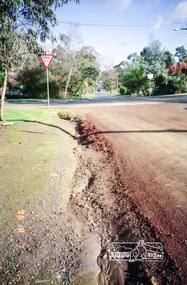
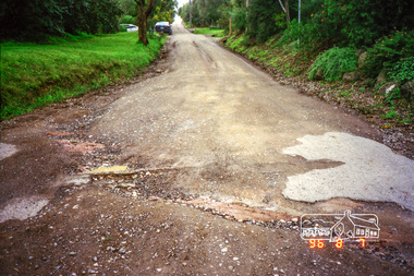
 Eltham District Historical Society Inc
Photograph, Road surface conditions around Eltham: Looking west along John Street at the intersection with Bible Street, 7 Aug 1996, 1996
Shows sections of Franklin, John and Napoleon streets were still unmade as of late 1996 and the condition of those roads with potholes at the intersections with Bible Street.Reflects on the changing nature of the local street-scape and housesRoll of 35mm colour negative film, 7 stripsKodak Gold 100-5eltham, napoleon street, bible street, franklin street, john street -
 Eltham District Historical Society Inc
Photograph, Road surface conditions around Eltham: Looking east along John Street at the intersection with Bible Street, 7 Aug 1996, 1996
Shows sections of Franklin, John and Napoleon streets were still unmade as of late 1996 and the condition of those roads with potholes at the intersections with Bible Street.Reflects on the changing nature of the local street-scape and housesRoll of 35mm colour negative film, 7 stripsKodak Gold 100-5eltham, napoleon street, bible street, franklin street, john street -
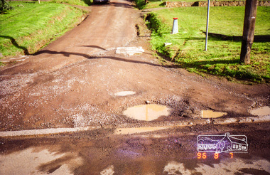
 Eltham District Historical Society Inc
Photograph, Road surface conditions around Eltham: Napoleon Street looking east from intersection with Bible Street, 7 Aug 1996, 1996
Shows sections of Franklin, John and Napoleon streets were still unmade as of late 1996 and the condition of those roads with potholes at the intersections with Bible Street.Reflects on the changing nature of the local street-scape and housesRoll of 35mm colour negative film, 7 stripsKodak Gold 100-5eltham, napoleon street, bible street, franklin street, john street -
 Eltham District Historical Society Inc
Photograph, Road surface conditions around Eltham: Napoleon Street looking west across Bible Street, 7 Aug 1996, 1996
Shows sections of Franklin, John and Napoleon streets were still unmade as of late 1996 and the condition of those roads with potholes at the intersections with Bible Street.Reflects on the changing nature of the local street-scape and housesRoll of 35mm colour negative film, 7 stripsKodak Gold 100-5eltham, napoleon street, bible street, franklin street, john street -
 Eltham District Historical Society Inc
Photograph, Road surface conditions around Eltham: Napoleon Street at Bible Street, Eltham, looking south-east, 7 Aug 1996, 1996
Shows sections of Franklin, John and Napoleon streets were still unmade as of late 1996 and the condition of those roads with potholes at the intersections with Bible Street.Reflects on the changing nature of the local street-scape and housesRoll of 35mm colour negative film, 7 stripsKodak Gold 100-5eltham, napoleon street, bible street, franklin street, john street -
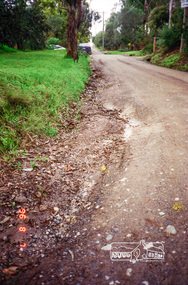
 Eltham District Historical Society Inc
Photograph, Road surface conditions around Eltham: Looking east along Franklin Street adjacent to No. 131, 7 Aug 1996, 1996
Shows sections of Franklin, John and Napoleon streets were still unmade as of late 1996 and the condition of those roads with potholes at the intersections with Bible Street.Reflects on the changing nature of the local street-scape and housesRoll of 35mm colour negative film, 7 stripsKodak Gold 100-5eltham, napoleon street, bible street, franklin street, john street -
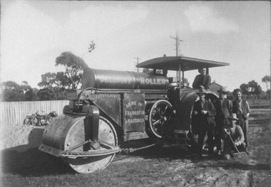 City of Ballarat Libraries
Photograph, Jelbart Road Roller circa 1930s
Jelbart Road Roller property of Shire of Frankston and Hastings circa 1930. This roller was manufactured in Ballarat by Jelbarts, whose foundry was located in Mair Street. jelbart, road roller, mair street, manufacturing, foundry, frankston, hasting, ballarat -
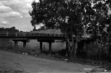 Melton City Libraries
Photograph, Bridge Road Bridge, Unknown
The Bridge Road Bridge built in 1913 by Sir John Monash for the Shire of Melton. It was built to provide railway station access to the new farming areas.Black and white photo of the bridgetransport, council