Showing 21411 items matching "high"
-
 Ballarat Tramway Museum
Slide - 35mm slide/s, Ben Parle, 8/04/1958 12:00:00 AM
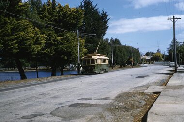
Kodachrome Transparency - 35mm slide - cardboard mount, with one side with red border and words "Kodachrome Transparency / Processed by Kodak" top and bottom. Photo taken by Ben Parle 8/4/1958. Has slide No. "9" stamped in black in top corner. Photo of Ballarat No. 19 between the Depot Loop and Martin Ave Loop, in Wendouree Parade, tram appears to have destination of Victoria St. Warning oncoming tramcar sign in the background at a tram stop. For high resolution scan see btm2868.tif"Lake Wendouree Ballarat" / "8-4-58"tramways, trams, wendouree parade, martin ave, lake wendouree, tram 19 -
 Ballarat Tramway Museum
Slide - 35mm slide/s, Ben Parle, 8/04/1958 12:00:00 AM
Kodachrome Transparency - 35mm slide - cardboard mount, with one side with red border and words "Kodachrome Transparency / Processed by Kodak" top and bottom. Photo taken by Ben Parle 8/4/1958. Has slide No. "12" stamped in black in top corner. Photo of Ballarat No. 11, Wendouree Parade, St Aidans Drive. Tram has the destination of Mt Pleasant. Note the cannon in the background, to the left of the tram. Both stone gate pillars shown. For high resolution scan see btm2871.tif"Lake Wendouree & Gardens / Ballarat" / "8-4-58"tramways, trams, wendouree parade, st aidans drive, tram 11 -
 Ballarat Tramway Museum
Slide - 35mm slide/s, Max Michell, Dec. 1968
White cardboard mount, 35mm slide, from the Association of Railway Enthusiast's film strip titled "Provincial Tramway Film Strip" of Bendigo 30, just after departure from North Bendigo terminus in Thunder St. Photo taken after the tram has passed the photographer. The film strip notes (Reg. Item 2560), provided the following caption details: "Birney No. 30 departs the terminus at "NORTH BENDIGO" - Dec '68 (Max Michell)" See image btm2591p.tif for high level scan of image. Stamped on base of slide "11801" and written in ink on top edge "No 30 Nth Bendigo"tramways, trams, are, film strip, north bendigo, thunder st, tram 30 -
 Ballarat Tramway Museum
Photograph - Digital image, late 1910's
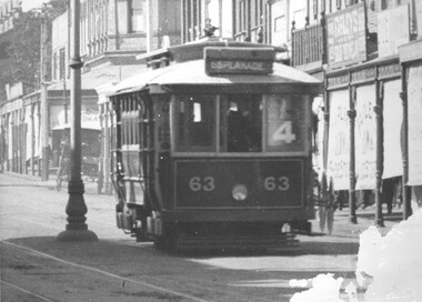
Yields information about a PMTT tramcar that was sold to Ballarat and an operating member of the BTM fleet.Digital Image of Prahran and Malvern Tramway Trust, Maximum Traction tramcar No. 63 in Glenferrie Road, with destination of Esplanade and Route No. 4 in the window of the tram. Tram later became Ballarat No. 18. In the background are shops, centre poles and blinds on the shops, indicating a summer's day perhaps. Detail from a Rose Series postcard. Possibly late 1910's. See image 2 for original enlarged postcard and high res images. Advised by Mal Rowe that he obtained from the Bob Prentice collection. trams, tramways, pmtt, glenferrie rd, tram 63, tram 18 -
 Bendigo Historical Society Inc.
Document - PETER ELLIS COLLECTION: LETTER FROM BENDIGO FIELD NATURALISTS CLUB
Photocopy of an unsigned letter from The Bendigo Field Naturalists Club with copies sent to the Ministry for Conservation, Premier of Victoria, National Estate Dept, Forests Commission of Victoria, Conservation Council of Victoria, Loddon Campaspe Regional Authority, The Hon D McClure MLA, the Hon F S Grimwade MLC, F J Granter MLC, N B Reid MLC and J Bourchier MP. Letter refers to the Purchase of land of high conservation value within the Bendigo Whipstick area for consideration in the National Estate Program.communication, postal, letters, peter ellis collection, the bendigo field naturalists club, national estate funds, forests commission of vict, wallaby caves, mr ruedin, conservation council of victoria, national estate dept, whipstick interim development order, loddon campaspe regional authority, the hon d mcclure mla, the hon f s grimwade mlc, f j granter mlc, n b reid mlc, j bourchier mp -
 Bendigo Historical Society Inc.
Programme - Bendigo Operatic Society: H.M.S. Pinafore
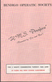
Items belonged to a Bendigo woman, born in 1919 who lived in Bendigo all her life and died at the age of 94 years. Program is for Bendigo Operatic Society's performance of H.M.S. Pinafore at Flora Hill High School Auditorium, for 5 nights commencing Tues 26th June (year not mentioned) consists of 4 pages, double sided print, folded in half & stapled in centre. Pink colored cover/back page & centre page. Black/white & some red ink print Program includes: names of Committee, Cast, black/white photos of production team & cast, synopsis of story & list of musical numbers & local advertisements souvenir programme, bendigo operatic society -
 Ballarat Tramway Museum
Functional object - Destination Roll, NSW Department of Road Transport and tramways, "Newcastle"
Destination roll use din a Newcastle tram - on linen, black background with various colours and white letters. Each destination 10" high. 6 joins in roll, each approx. 800 to 900 long section. Letters in caps. Destinations shown are: West Wal'send Wallsend and Platsburg New Lambton Lambton Broadmeadow Adamstown Waratah Merewether B'H (Beach) Newcastle Tighe's Hill Mayfield Glebe Boreas Road Special Depot Sport Grd Show Grd Racecourse Speedway Telford St Hamilton Depottram, trams, newcastle, destination roll -
 Kew Historical Society Inc
Photograph - Double-fronted Edwardian Villa, c.1918
The Kew Historical Society's map collection includes a substantial number of real estate subdivision plans, mainly of Kew but also of surrounding suburbs in Melbourne. Most of the subdivision plans date from the 1920s and 1930s when the districts old homes and local farmland were being split up to accommodate residential growth in the postwar period. These early plans were assembled by a local firm, Jas R Mather & McMillan, which had an office in Cotham Road. Many of the plans, and sometimes photos, were annotated by the agents.Subdivision plans are historically important documents used as evidence for the growth of suburbs in Australia. They frequently provide information about when the land was sold as well as evidence relating to surveyors and real estate and financial agents. The numerous subdivision plans in the Kew Historical Society's collection represent working documents, ranging from the initial sketches made in planning a subdivision to printed plans on which auctioneers or agents listed the prices for which individual lots were sold. In a number of cases, the reverse of a subdivision plan in the collection includes a photograph of a house that was also for sale by the agent. These photographs provide significant heritage information relating house design and decoration, fencing and household gardens.The photograph may also be aesthetically significant depending on the importance of the photographic atelier.On the reverse of a subdivision plan of the Palmyra Estate (Kew) is a photograph of a double-fronted Edwardian villa. The weatherboard and stucco house with high brick chimneys provides a clear indication of the style of curtains and gardens in houses of the period. Holland blinds with lace inserts are used in the left front window. They are combined with long lace curtains. The garden, with its curved pathway is bordered with garden beds that include marguerite daisies and roses. Reflecting a new interest in the Australian landscape, tree ferns and ground ferns are planted closer to the house.houses - kew, architecture - edwardian, real estate photographs -
Kew Historical Society Inc
Archive (Sub-series) - Subject File, DAKIN Family, 1958
Various partiesReference, Research, InformationSecondary Values (KHS Imposed Order)Subject file containing information on the Dakin family of Kew, whose sons attended Trinity Grammar School. Jane Carolan, the archivist of Trinity Grammar School, compiled the research notes. The information in the file relates to Arthur William Dakin and Frances E Dakin. Jane Carolan’s research covers the period 1904-1950. Robert Baker used the notes to develop a newsletter article on the Kew High School trophy won by Arthur Dakin. [Arthur Dakin was later a member of the Ross River Rescue Mission of 1917.]arthur dakin, kew high school, trinity grammar school, ross river rescue mission, frances dakinarthur dakin, kew high school, trinity grammar school, ross river rescue mission, frances dakin -
Kew Historical Society Inc
Archive (series) - Subject File, Kew Historical Society, JELLIS, Thomas G, 1958
Various partiesReference, Research, InformationSecondary Values (KHS Imposed Order)Subject file containing research and primary sources relating to T.G. Jellis and his family bakery in High Street, and later Studley Park Road, Kew. It includes a 1-page summary compiled by Elizabeth Mackie of an interview with his daughter Mrs Whitney, which was separately recorded on tape. A later document is a reminiscence of the bakery in Studley Park Road by Trevor D. Fiander of Ballan. This document includes drawings of the exterior and interior. [An article on the bakery can also be accessed in KHS Newsletter No.104 September 2013.kew historical society - archives, kew - history, t.g. jellis, mayors of kew - t.g. jellis, bakeries - kew (vic), mrs whitney (1895-?), trevor fianderkew historical society - archives, kew - history, t.g. jellis, mayors of kew - t.g. jellis, bakeries - kew (vic), mrs whitney (1895-?), trevor fiander -
 Kew Historical Society Inc
Plan - Subdivision Plan, Golf View Estate, c.1922
Pru Sanderson, in her groundbreaking ‘City of Kew Urban Conservation Study : Volume 2 - Development History’ (1988), summarised the periods of urban development and subdivisions of land in Kew. The periods that she identified included 1845-1880, 1880-1893, 1893-1921, 1921-1933, 1933-1943, and Post-War Development. These periods were selected as they represented periods of rapid growth or decline in urban development. An obvious starting point for Sanderson’s groupings involved population growth and the associated economic cycles. These cycles also highlighted urban expansion onto land that was predominantly rural, although in other cases it represented the decline and breakup of large estates. A number of the plans in the Kew Historical Society’s collection can also be found in other collections, such as those of the State Library of Victoria and the Boroondara Library Service. A number are however unique to the collection.The Kew Historical Society collection includes almost 100 subdivision plans pertaining to suburbs of the City of Melbourne. Most of these are of Kew, Kew East or Studley Park, although a smaller number are plans of Camberwell, Deepdene, Balwyn and Hawthorn. It is believed that the majority of the plans were gifted to the Society by persons connected with the real estate firm - J. R. Mathers and McMillan, 136 Cotham Road, Kew. The Plans in the collection are rarely in pristine form, being working plans on which the agent would write notes and record lots sold and the prices of these. The subdivision plans are historically significant examples of the growth of urban Melbourne from the beginning of the 20th Century up until the 1980s. A number of the plans are double-sided and often include a photograph on the reverse. A number of the latter are by noted photographers such as J.E. Barnes.The subdivision advertised as the Golf View Estate in Camberwell included 32 allotments bordering on Glen Iris Road, Smith Street (now Smith Road), St Andries Street and Camberwell Road. In the post-war period in which the subdivision took place, the significance of Camberwell as the ‘Heathiest of Suburbs’ because of the undulating nature of its terrain and its high altitude was promoted. The sales pitch aimed at attracting and selling to ‘Gentlemen’ who could take advantage of the nearby trams, which would take them to the ‘heart of the city’.subdivision plans - camberwell, golf view estate -
 Kew Historical Society Inc
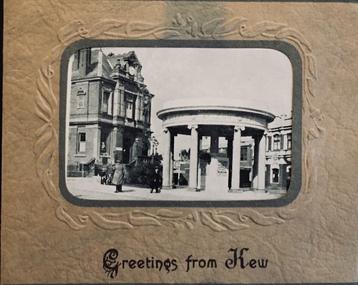
Postcard, Greetings from Kew, c.1928
An item from an outstanding and diverse photographic collection, assembled by members of the Christian and Washfold families of Kew.Rae series of postcards, otherwise unknown, showing important sites in KewSmall folding postcard including nine black and white postcard views of Kew. Cover depicts Kew War Memorial set within an embossed cardboard frame. Individual postcards include: Studley Park Road, River Yarra showing new Bridge [Chandler Hwy], High Street showing soldier's memorial, River Yarra at Victoria Bridge, The Yarra at Studley Park, Holy Trinity Church, the [Alexandra] Gardens, New Yarra Bridge [Burke Rd], Soldiers' Memorial and Post Office Kewwashfold family, christian-washfold collection, postcards -- kew (vic.) -
 Kew Historical Society Inc
Map, MMBW, MMBW Plan No.67 Kew, 1900-1910
The Melbourne and Metropolitan Board of Works (MMBW) was established by an act of the Victorian Parliament in 1890 to prepare for and to implement a sewerage and water reticulation system across what was then inner Melbourne, its surrounding and middle distance suburbs, including Kew. The MMBW was disbanded in 1991.The map collection of the Kew Historical Society has at its core the historic maps assembled and originally stored in the City Engineer's Department of the City of Kew. These include maps in a number of scales. The vast majority of maps were produced by the MMBW in the first two decades of the twentieth century, and are solid working maps, backed by linen for durability. These maps are historically significant to Kew, the City of Boroondara and to the history of the development of state utilities in Victoria. A number of the Kew maps have additional details added by former municipal officers, including the levels reached by various floods. As these were working documents, information was added to them long after the period of their initial production and distribution.Early map of part of the Borough of Kew, created in the first decade of the twentieth century, at a scale 160 ft to 1 inch. The map covers what was then the north central part of Kew, bordered on its north by the Outer Circle Railway Spruzen and Beresford Avenues, in the west by Princess Street, in the south by High Street, and in the east by (about) Belford Road. The map shows the extent of urban development by that time, prominent institutions and the outlines of built structures in the municipality. Contour lines were added in ink to the map at a later stage.MELBOURNE AND METROPOLITAN BOARD OF WORKS / PLAN NO. 67 / KEW melbourne & metropolitan board of works, mmbw maps, mmbw plans, borough of kew, cartography -
 Falls Creek Historical Society
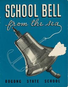
Booklet - School Bell from the sea - Bogong State School
This booklet tells the story of the bell from the "S. S. Santhia" and how it came to Bogong State School, Victoria. "Santhia" belonged to the British India Line. On 6th November 1943 she was in service as a troopship when she caught fire and capsized at No. 3 Garden Reach Jetty, Calcutta. Due to the additional weight of water pumped into her to extinguish the fire, "Santhia" heeled over and remained in the mud of the River Hooghly until a successful salvage was completed in January 1946. The salvage operation was carried out by Captain J. P. Williams of Melbourne and his team of Australian divers nine and a half months after the commencement of operations. "Santhia" was the sixty seventh ship salvaged by Captain Williams. "Santhia's" Bell was presented by Captain Williams to Mr G.G. Jobbins, Chairman of Commissioners for installation at Bogong State School. The ceremony of presenting the bell took place on 21st February 1947. The bell bears the following inscription:- "Presented to G.G.Jobbins, Esq., Chairman, State Electricity Commission, by Captain J.P. Williams for Bogong School, on December 6th, 1946. This bell was recovered from the wreck of the "S.S.Santhia" sunk in the Hooghly River, Calcutta, and raised by an Australian salvage party."This booklet is significant because it documents an unusual event linking Bogong State School to a World War II salvage operation.A booklet consisting of images and text which tells the story of S.S. Santhia, of her sinking while in service as a troopship, of her subsequent salvage and how her bell came to Bogong State School in Victoria's High Country. The booklet consists of 12 pages including the cover. It consists of text and images. Primarily printed in black and white, the booklet uses blue boxes to highlight text including titles and explanation of images. The cover is blue with white text and features an image of the bell of the S. S. Santhia.Inside front cover: THIS BOOKLET is presented by THE STATE ELECTRICITY COMMISSION OF VICTORIA to the children of BOGONG STATE SCHOOLbogong state school, s.s.santhia, santhia bell -
 Woodend RSL
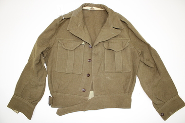
Uniform - Battle Dress - Jacket
Example of Australian military battledress Jacket - Battledress of olive drab fabric. Jacket is short, and designed to be buttoned to the outside of high-waisted wool serge trousers. An olive green band with two button holes is attached to the inner lower band. The jacket has a fabric belt across the front, with a buckle. Two rectangular pockets extend beneath the lapels. Inside of jacket has a sewn on, rectangular identification label, and size label. Jacket has four buttons down side front, and one near lapel. Each cuff has a button.Identification label on inside of jacket (black ink): REGIMENTAL No NAME Size label (red ink): M. TX SIZE 17 Faint mark on inner neck lining in red marker, possibly Kbattledress, jacket, military, uniform, outfit, fashion, world, war, australian. -
City of Kingston
Photograph - Colour, 29 January 1993
Bonbeach, Carrum and Patterson Lakes are suburbs in the City of Kingston. Bonbeach and Carrum were holiday destinations in early 20th century and over time the housing has converted to permanent residential structures. In Patterson Lakes, the area consists predominantly of newer housing developments and the tidal canal system which is accessible to many dwellings joins Port Phillip Bay.Bonbeach, Carrum and Patterson Lakes were previously part of the extensive Carrum Carrum Swamp. The area was once a source of fish and eels for the Mayone-Bulluk clan of the Bunurong people. Over time the area was drained and this allowed farming at Carrum and Bonbeach, although the area was prone to flooding. In the early 1920s and 30s the land was converted to residential dwellings. In 1973 investigations commenced nearby to Bonbeach and Carrum into the development of a unique residential area comprising canals and waterways. It was originally proposed to be known as "Gladesville". Circa 1974, the area was rezoned from rural to residential and named Patterson Lakes. Development has been continuous since the 1970s with staged construction of the waterways, residential housing, and supporting infrastructure and facilities.Laminated colour aerial photograph of the Bonbeach, Carrum and Patterson Lakes region within City of Kingston. This 1993 image includes Bonbeach High School prior to demolition, Bonbeach Primary School and Patterson River Golf Club. Sections of Patterson Lakes are not yet developed, including Rhode and Staten Islands. Long Island Point appears to be a recent development with many spare blocks and new houses under construction. The Patterson River marina is prominent and the river mouth as it meets Port Phillip Bay. The Carrum railway station is visible.Black type on white adhesive sticker: No. 6661 Black type on white adhesive sticker: 26E/6661, 29/1/93, 4.25 pm Black type on white adhesive sticker 29-1-93 Yellow circular adhesive stickerbonbeach, carrum, patterson lakes, patterson river, carrum carrum swamp, canals and waterways -
 Bacchus Marsh & District Historical Society
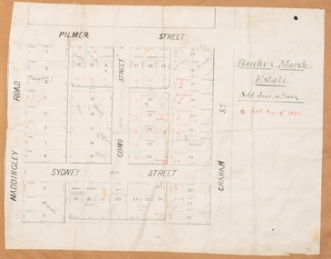
Map, Bacchus Marsh Estate sold 30th June 1888 and sold 28 December 1895
Blocks of land in this area of Bacchus Marsh were sold in lots between 1888 and the late 1890s. This map shows sales made in 1888 and 1895.Single page map showing allotments of land bounded by Pilmer Street, Graham Street, Sydney Street and Maddingley Road (Grant Street) in Bacchus Marsh.The area is dissected by Como Street down the central area. 43 blocks of land are shown with the names of buyers or sellers in 1888 written in black in. Buyers or sellers for December 1895 are written in red ink. Part of a set of maps which are pasted into a bound volume containing 76 maps or plans in total. High resolution digital image stored on BMDHS computer network. bacchus marsh victoria maps, land sales bacchus marsh, pilmer street bacchus marsh, graham street bacchus marsh, sydney street bacchus marsh, como street bacchus marsh, maddingley road bacchus marsh, grant street bacchus marsh -
 Bendigo Historical Society Inc.
Document - BENDIGO CEMETERIES COLLECTION: SELF GUIDED TOUR NO.7 DOCUMENT
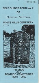
BHS CollectionBlue coloured document, trifold. Self Guided Tour No. 7 of Chinese Section, White Hills Cemetery, Friends of the Bendigo Cemeteries 2-001 - 2002. Theme 'A hundred years after Federation' Map with numbered grave sites, with descriptions e.g. Louey Ah Pon, passenger involved in a fatal car accident with a bus on High St., a market gardener of Golden Square. Chung Fook Jao, committed suicide in his hut on the New Chum Mine site where he had worked the tailing for many years.Friends of the Bendigo Cemeteries 2000bendigo, cemetery, white hills cemetery tour -
 Bendigo Historical Society Inc.
Sculpture - JOHN BOMFORD PSYCHIATRIC CENTRE, COPPER BAS RELIEF MYTHOLOGICAL GOAT
Bomford Bas Relief Mythological Goat. Created from Sheet Copper. Carved and hammered Bas relief of a mythological creature resembling a goat with long straight horns. The Carving was created by an artist in residence at the Bendigo Psychiatric Centre ( Golden City Support Services) prior to closure. It is approximately 1.5metres high and 1.00metre wide. Mounted on a Large green wooden board. See 7312 also. Items represent the constellations Capricorn and Aquila. Once completed, they were used to identify the Squila and Capricorn patient areas at the Psychiatric Centre.artwork, sculpture -
 Linton and District Historical Society Inc
Photograph, Isobel Antoinette McDonagh
Isobel Antoinette McDonagh (her first name also spelled Isabel, Isabell, Isabella) was born in Jamaica in 1847, a daughter of Robert & Antoinette McDonagh. In 1851, in Ireland, Isobel and her sister Jane were orphaned after both their parents died within a few months of each other. In 1855 Isobel and her sister came to Australia with their uncle John McDonagh and his wife Martha (née Mathews). Following the death in childbirth of her sister Jane in 1878, Isobel married her brother-in-law Frederick William Mitchell in 1881. She was the mother of Frederick William Mitchell, Robert Harold Mitchell, Albert Earnest Mitchell, Ida Olive Mitchell and Lillian (or Lily) Isabell Mitchell.Painted/modified black and white photograph which has been printed on glass, depicts a young lady with hair drawn back from face and worn in a bun or chignon at the back, wearing a dark coloured dress with a high neck and some trimming on bodice and sleeves. A narrow frill of white lace(?) is visible above the collar. Afterwards Mrs. Frederick Mitchell Several pages from a book have been pasted onto the back of the glass on which the photograph is printed. There is some writing in pencil (arithmetic calculation?) across these pages.isobel antoinette mcdonagh, isobel antoinette mitchell -
 Bendigo Historical Society Inc.
Negative - TOM PATULLO COLLECTION: A COUNTRY TOWN
Negative print. Rosalind Park (Camp Reserve), Bendigo looking over Park Road, the Bendigo Creek, Camp Hill State School, with the Bendigo Masonic Hall Left and the Government Camp on the top of the Hill; near where the present day lookout tower stands; to the left of the state school. The Consolidated High School is on the extreme right hand side. The police barracks are between the two schools. The original consolidated school building has been built around and is incorporated into the current Bendigo Senior Secondary School buildings.bendigo, sandhurst, tom patullo collection, bullock wagon, camp reserve bendigo, rosaling park bendigo, camp hill school, bendigo consolidated high school -
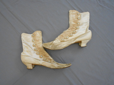 Bendigo Historical Society Inc.
Clothing - MAGGIE BARBER COLLECTION: PAIR OF SATIN BUTTON - UP BOOTS, Mid to late 1800's
Clothing. Deep cream silk (?) satin button-up boots/shoes. Immaculate, tiny stitching. Low, Louie shaped heel. Ankle high boots. Buttoning opening on the outside edge-eight scallops each finely bound and stitched. Each fastened by a tiny 8mm domed painted button, and an immaculate, stitched buttonhole. Sadly, the satin has split, on each opening panel. Some colouring has been chipped from the buttons. Inside it would appear that the satin has a linen backing or lining.Inside is a gold stamp F.PINET. PARIS Also is a stamp, J.WATTS 23 BOURKE ST. EAST MELBOURNE. 25 1/2 3. BREVETTE F.PINET 27PARIScostume, female, satin button-up boots -
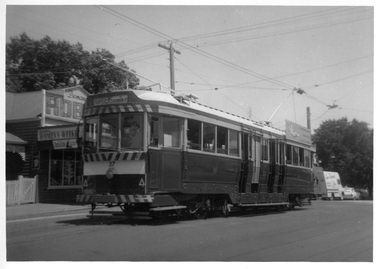 Ballarat Tramway Museum
Photograph - Black & White Photograph/s, Bob Lilburn, 17/01/1969 12:00:00 AM
Black and white photograph of Ballarat tram No. 37 at the Mt Pleasant terminus. Tram has destination of "Gardens via Drummond Nth.", roof advertisement for the SEC "Everything's under control in my all electric kitchen". Shop on the left hand side of the photo has Robur Tea company, Coca Cola and Women's Weekly advertisements. High Res image added 8/5/2019 from Peter Lambert. 2nd print - dates the photo as 17-1-1969 a photo by Bob Lilburn.On rear of 2nd image - "2nd Ballarat 37, Mt Pleasant, Ex Bendigo 1, Ex Geelong 35" and "ex MMTB 119, 17-1-69"trams, tramways, mt pleasant, barkly st, tram 37 -
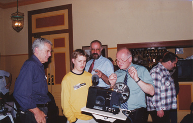 Ballarat Tramway Museum
Photograph - Colour Photograph/s, Austin Brehaut, 22/09/2001 12:00:00 AM
Colour photograph or print of a group watching Richard Gilbert setting up the movie projector for the films at the Ballarat Tramway Museum 30th Anniversary dinner on 22/9/2002. On Kodak Royal Paper. Photo by Austin Brehaut. Caption supplied by Austin at the depot for the photo was "High Technology at the 30th Anniversary Dinner. Warren knows what is it, Peter and Sam are apprehensive, Richard is fascinated, Stephen isn't interested." In photo left to right are Peter Winspur, Sam Boon, Warren Doubleday, Richard Gilbert and Stephen Butler"On rear in blue ink "Home movie time at 30th Anniversary Dinner for BTPS 22.9.01. L-R Peter Winspur, Sam Boon, Warren Doubleday, Richard Gilbert and Stephen Butler"30th anniversary, dinner, btm, films -
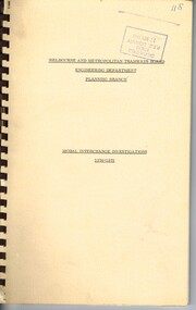 Melbourne Tram Museum
Document - Tender Document, Melbourne & Metropolitan Tramways Board (MMTB), "Engineering Department - Planning Branch - Modal Interchange Investigations 1974 - 1975", 1975
Comb bound (brown plastic) report, manila card covers, approx. 10 pages, plus yellow sheets plus four folded drawings titled "Engineering Department - Planning Branch - Modal Interchange Investigations 1974 - 1975". Study looks at five possible modal interchanges: 1. - Box Hill Railway Station 2. - High St / Harp Road, Kew 3. - St Kilda Road / Park St / Domain Road 4 - Swanston St and Flinders St station 5 - Blackburn Railway station.In red felt pen on top right hand corner "(118)". Has stamp "Discarded from PTC Library 22 Oct. 1989" on front cover and the first sheet.trams, tramways, mmtb, tram stops, railways, domain junction, swanston st, flinders st station, blackburn -
 Melbourne Tram Museum
Document - Report, Melbourne & Metropolitan Tramways Board (MMTB), "Parliamentary Public Works Committee - Eastern Railway Inquiry No. 2 - Evidence on Behalf of the MMTB", Aug. 1974
Report - Foolscap - 8 sheets stapled in the top left hand corner, titled "Parliamentary Public Works Committee - Eastern Railway Inquiry No. 2 - Evidence on Behalf of the MMTB", dated 14/8/1974. Provides details of the MMTB schemes, high standard bus system and light railway style. Looks at the bus routes, possible light rail routes, advantages of each, patronage, costs and comparison of the schemes. Refers to figures which were not with report. See Reg Item for the detailed August 1974 original report.In top left hand corner "Mr Lees" in ink.trams, tramways, new tramways, doncaster, light rail, buses, parliament, submissions -
 Ballarat Tramway Museum
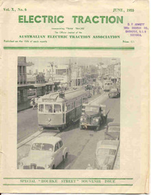
Magazine, Australian Electric Traction Association (AETA), "Electric Traction", Jun. 1955
Yields information about the construction method of High St Northcote Melbourne, Bourke St and the construction of the new trams at the time for Melbourne.June 1955 issue of Electric Traction, Vol X No. 6 - featuring Melbourne No.996 in High St Northcote, during the construction of the tramway with two trams being ferried to the new Preston depot. See detail caption. Only one line shown, the second is under construction in the rear. Features articles on the construction of the Bourke St routes, construction of new W7 (known then as SW6c), tramcars, possible new routes in Melbourne, news from Pittsburgh, Victorian Railways, Bourke St. roll, AETA notes.Stamp of "D.F. Jowett etc" in top left hand corner.trams, tramways, melbourne, bourke st, tramcar construction -
 Bendigo Historical Society Inc.
Document - NEW CHUM & VICTORIA LINES OF REEF - MINING MACHINERY, NEW CHUM LINE, EAGLEHAWK
Handwritten notes on mining machinery sold at auction. South St Mungo - Winding Engine. Pair of 15 ? Cyl. Winding Engines. 7 ft Winding Gear. Also, Jackass Boiler. Feed Pump, Trucks, Rails, Flat Sheets, Poppet Heads, Housing, etc. Sold for 270 pounds. Purchaser H Ralph for Austral Drill Co. Lady Barkly Company - 12-inch Cylinder Winding Engine. 8 ft Winding Gear. Cornish Flue Boiler, Feed Pump, Rails, Poppet Heads, Housing, etc. Sold for 162 pound 10 shillings. Purchaser W. J. Sever, Mining Merchants, Melb. Crushing Battery - Complete 40 Head Battery. Tandem Compound Engine. 11 in & 22 in Cylinders. High Press, Boilers, Electric Lighting Plant. 6 in Cyl. High Speed Engine, Fire-proof, Feed Pump, Rails, Flat Sheets, Tools & Sundries. 1000 pound to R. Ralph. These three mining plants, complete. Sold by Messrs. Bell, Lambert and Nixon - Auctioneers. Ref; Bendigo Advertiser. July 14th, 1910, Page 2.document, gold, new chum & victoria lines of reef, mining machinery new chum line eaglehawk, south st mungo, h ralph, austral drill co, lady barkly company, w j sever, crushing battery, messrs bell, lambert and nixon -
 4th/19th Prince of Wales's Light Horse Regiment Unit History Room
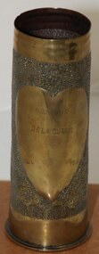
Decorative object - Trench Art, Shell Case, c 1919
Brass shell case. Engraved as trench artBody has 1 mm dot punched close pattern leaving 2 x 13 cm high heart shaped spaces on opposite sides. One space is engraved with AMF Rising Sun badge under which is Australian Coat of Arms. Other space: "SOUVENIR DE LA GURRE (Sic) 1914 1919" On base: St, G, 62, APRIL 1917, "HL" over "25" world war one, france, trench art, western front, shell case, ww, world war one, france, trench art, western front, shell case, ww -
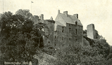 Federation University Historical Collection
Postcard, Roslin, c1945
Roslin Castle, the seat of the St Clair Family, was founded in 1304. It is partly in ruins. According to legend some millions of pounds worth of treasure being hidden in the vaults. it is said to be under the charge of a lady of the ancient St Clair family. She is to wake from her slumber and point out the spot where the treasure lies. It is located near the village of Roslin in Midlothian, Scotland. It is located around 9 miles south of Edinburgh, on the north bank of the North Esk, only a few hundred metres from the famous Rosslyn Chapel. (See http://en.wikipedia.org/wiki/Roslin_Castle)Three postcards showing different views of Roslin Castle. .1) A stone building on a hill side, with flying flag, .2) The Courtyard, Roslin Castle .3) The Bakehouse, Roslin Castle.1) This a fine view taken from the Glen. Formerly the castle was eight storeys high, five above and three underground. .2) While at Edinburgh I went out to Roslin saw there the Castle and Church. They are both very old dating back 500 hundred years. .3) The hole in the wall is the oven, is an immense thing. A fire was lit in the oven then pulled out and the heat in the stone did the baking.roslin, rosslyn, roslin castle, st clair, spirit, ghost, baking, oven, bread