Showing 13827 items
matching tasmanian-built
-
 Bacchus Marsh & District Historical Society
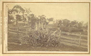
Photograph, Agave Americana plant with view of Anglican and Presbyterian Churches in background, Bacchus Marsh 1883
This image appears to have been created to depict this good size Agave Americana plant, also known as the 'Century Plant'. Agaves are an introduced species to Australia. Their local propagation in Victoria is mentioned in Victorian newspapers as early as the 1850s. By the 1870s they appear to have become fairly common but still relatively novel. The side by side view of the Holy Trinity Anglican and Saint Andrews Presbyterian Churches forms an interesting frame for this botanical study. On the far right of the image in the background can be seen the Presbyterian Church Manse built in 1858 and demolished in the 20th century.Small sepia 'carte de viste' style unframed photograph on card with gold border framing photograph. Housed in the Jeremeas Family Album which contains photographs of Bacchus Marsh and District in 1883 by the photographers Stevenson and McNicoll. In the foreground of this image is an Agave Americana plant growing alongside a post and rail fence. In the background can be seen the Anglican Holy Trinity Church on the left and Saint Andrews Presbyterian Church on the right.Printed On the front: Stevenson & McNicoll. Photo. 108 Elizabeth St. Melbourne. COPIES CAN BE OBTAINED AT ANY TIME. On the back: LIGHT & TRUTH inscribed on a banner surmounted by a representation of the rising sun. Copies of this Portrait can be had at any time by sending the Name and Post Office Money Order or Stamps for the amount of order to STEVENSON & McNICOLL LATE BENSON & STEVENSON, Photographers. 108 Elizabeth Street, MELBOURNE. stevenson and mcnicoll 1883 photographs of bacchus marsh and district, churches bacchus marsh, holy trinity anglican church bacchus marsh, holy trinity church of england bacchus marsh, saint andrews presbyterian church bacchus marsh, plants, agaves, exotic plants, agave americana -
 Lakes Entrance Historical Society
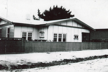
Photograph - Historic House, 2000
This residence named 'Mourilyan' was built in 1892 beside Harbeck's Store, Lakes Entrance, as a family residence. It was altered and extended in 1927. In 1968 it was relocated to present site in Williams Road. The entrance steps and stonework were constructed by Rev A E Clark. Internal renovations during 1990's. Continually occupied by Harbeck family and descendents. Also a colour photograph of the front entrance of same dwelling in new location at Williams Road, Lakes Entrance. Also one colour photograph of the front entrance of same dwelling in new location at Williams Road Lakes Entrance VictoriaBlack and white photograph of a fibro dwelling on Esplanade, beside Harbecks's Store. Lakes Entrance Victoriahouses, heritage study -
 Kew Historical Society Inc
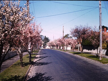
Photograph - Yarra Street, Kew, Ron Setford, 1960
Ron Setford and his wife Grace Setford lived in Tanner Avenue, East Kew, from c.1946 to c.1995. A keen photographer, he recorded the changing face of Kew over a 20 year period. Apart from 30 photographs of built structures and places in Kew dating from 1960 and 1961, 145 of his 35mm colour slides chronicle the development of the Eastern Freeway through the Yarra Valley over a five year period from c.1972 to c.1977. This important collection was donated to the Society by his granddaughter in 2025.This collection of 175 35mm slides is of local and statewide significance, owing to its subject matter, particularly the major development of road transport infrastructure during the 1970s with the construction of the Eastern Freeway. The photographer also took care to annotate and date most of his slides which enable the researcher to pinpoint temporal and spatial locations.Yarra Street was not made a trafficable thoroughfare until October 1956. Until then, the gully was used as a dump, a shortcut to the river, and for communal Guy Fawkes night bonfires. The open landscape in the photo reflects near-total clearing by the original estate owners for grazing livestock. Post-war homes fronting Stawell St dot the landscape. Of particular note are the Broons House (c.1952–54) by Anatol Kagan (top right), and the homes of two architects, Kurt Elsner (c.1950) (middle) and Geoffrey Danne (c.1954) (lower right). Dual carriageways made blocks accessible, but building was difficult due to steeply sloping land and complex drainage easements. Nevertheless, these challenges resulted in highly innovative designs, making Yarra Street the core of the Yarra Boulevard Heritage Precinct."Yarra St Kew"ron setford, photographs -- kew (vic.) -- 1960s, yarra street -- kew (vic.) -
 Kew Historical Society Inc
Photograph - Kew Civic Offices, Ron Setford, 1973
Ron Setford and his wife Grace Setford lived in Tanner Avenue, East Kew, from c.1946 to c.1995. A keen photographer, he recorded the changing face of Kew over a 20 year period. Apart from 30 photographs of built structures and places in Kew dating from 1960 and 1961, 145 of his 35mm colour slides chronicle the development of the Eastern Freeway through the Yarra Valley over a five year period from c.1972 to c.1977. This important collection was donated to the Society by his granddaughter in 2025.This collection of 175 35mm slides is of local and statewide significance, owing to its subject matter, particularly the major development of road transport infrastructure during the 1970s with the construction of the Eastern Freeway. The photographer also took care to annotate and date most of his slides which enable the researcher to pinpoint temporal and spatial locations."Kew - "Taj-Mahal" / Cotham Rd - Charles St / Oct 73"ron setford, kew civic offices -
 Kew Historical Society Inc
Photograph - Kew Civic Offices, Ron Setford, 1973
Ron Setford and his wife Grace Setford lived in Tanner Avenue, East Kew, from c.1946 to c.1995. A keen photographer, he recorded the changing face of Kew over a 20 year period. Apart from 30 photographs of built structures and places in Kew dating from 1960 and 1961, 145 of his 35mm colour slides chronicle the development of the Eastern Freeway through the Yarra Valley over a five year period from c.1972 to c.1977. This important collection was donated to the Society by his granddaughter in 2025.This collection of 175 35mm slides is of local and statewide significance, owing to its subject matter, particularly the major development of road transport infrastructure during the 1970s with the construction of the Eastern Freeway. The photographer also took care to annotate and date most of his slides which enable the researcher to pinpoint temporal and spatial locations."Kew Taj-Mahal"ron setford, kew civic offices -
 Kew Historical Society Inc
Photograph - Kew Civic Offices, Ron Setford, 1973
Ron Setford and his wife Grace Setford lived in Tanner Avenue, East Kew, from c.1946 to c.1995. A keen photographer, he recorded the changing face of Kew over a 20 year period. Apart from 30 photographs of built structures and places in Kew dating from 1960 and 1961, 145 of his 35mm colour slides chronicle the development of the Eastern Freeway through the Yarra Valley over a five year period from c.1972 to c.1977. This important collection was donated to the Society by his granddaughter in 2025.This collection of 175 35mm slides is of local and statewide significance, owing to its subject matter, particularly the major development of road transport infrastructure during the 1970s with the construction of the Eastern Freeway. The photographer also took care to annotate and date most of his slides which enable the researcher to pinpoint temporal and spatial locations."Kew Council Offices"ron setford, kew civic offices -
 Kew Historical Society Inc
Photograph - Kew Civic Offices, Ron Setford, 1973
Ron Setford and his wife Grace Setford lived in Tanner Avenue, East Kew, from c.1946 to c.1995. A keen photographer, he recorded the changing face of Kew over a 20 year period. Apart from 30 photographs of built structures and places in Kew dating from 1960 and 1961, 145 of his 35mm colour slides chronicle the development of the Eastern Freeway through the Yarra Valley over a five year period from c.1972 to c.1977. This important collection was donated to the Society by his granddaughter in 2025.This collection of 175 35mm slides is of local and statewide significance, owing to its subject matter, particularly the major development of road transport infrastructure during the 1970s with the construction of the Eastern Freeway. The photographer also took care to annotate and date most of his slides which enable the researcher to pinpoint temporal and spatial locations."The "Taj-Mahal" / $1.250.000 Council Offices (we have to pay for it)"ron setford, photographs -- kew (vic.) -- 1960s, kew civic offices, kew town hall -
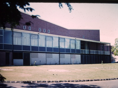
 Kew Historical Society Inc
Photograph - Kew Civic Hall and World War II War Memorial, Ron Setford, 1960
Ron Setford and his wife Grace Setford lived in Tanner Avenue, East Kew, from c.1946 to c.1995. A keen photographer, he recorded the changing face of Kew over a 20 year period. Apart from 30 photographs of built structures and places in Kew dating from 1960 and 1961, 145 of his 35mm colour slides chronicle the development of the Eastern Freeway through the Yarra Valley over a five year period from c.1972 to c.1977. This important collection was donated to the Society by his granddaughter in 2025.This collection of 175 35mm slides is of local and statewide significance, owing to its subject matter, particularly the major development of road transport infrastructure during the 1970s with the construction of the Eastern Freeway. The photographer also took care to annotate and date most of his slides which enable the researcher to pinpoint temporal and spatial locations."Kew Town Hall"ron setford, photographs -- kew (vic.) -- 1960s, kew town hall -
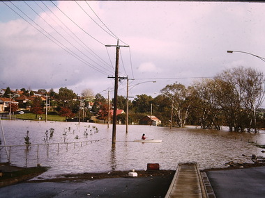 Kew Historical Society Inc
Photograph - Flooding, Kilby Road, Kew, Ron Setford, 1974
Ron Setford and his wife Grace Setford lived in Tanner Avenue, East Kew, from c.1946 to c.1995. A keen photographer, he recorded the changing face of Kew over a 20 year period. Apart from 30 photographs of built structures and places in Kew dating from 1960 and 1961, 145 of his 35mm colour slides chronicle the development of the Eastern Freeway through the Yarra Valley over a five year period from c.1972 to c.1977. This important collection was donated to the Society by his granddaughter in 2025.This collection of 175 35mm slides is of local and statewide significance, owing to its subject matter, particularly the major development of road transport infrastructure during the 1970s with the construction of the Eastern Freeway. The photographer also took care to annotate and date most of his slides which enable the researcher to pinpoint temporal and spatial locations."Flood Kilby Road / May 74"ron setford, floods -- kew (vic.), kilby road -- kew (vic.) -
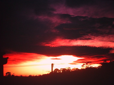 Kew Historical Society Inc
Photograph - Sunrise over Kew East, Ron Setford, 1969
Ron Setford and his wife Grace Setford lived in Tanner Avenue, East Kew, from c.1946 to c.1995. A keen photographer, he recorded the changing face of Kew over a 20 year period. Apart from 30 photographs of built structures and places in Kew dating from 1960 and 1961, 145 of his 35mm colour slides chronicle the development of the Eastern Freeway through the Yarra Valley over a five year period from c.1972 to c.1977. This important collection was donated to the Society by his granddaughter in 2025.This collection of 175 35mm slides is of local and statewide significance, owing to its subject matter, particularly the major development of road transport infrastructure during the 1970s with the construction of the Eastern Freeway. The photographer also took care to annotate and date most of his slides which enable the researcher to pinpoint temporal and spatial locations."Sunrise over East Kew [Aug69}"ron setford, photographs -- kew (vic.) -- 1960s, kew east -
 Kew Historical Society Inc
Photograph - Kew Bowling Club -- Wellington Street (Kew), Ron Setford
Ron Setford and his wife Grace Setford lived in Tanner Avenue, East Kew, from c.1946 to c.1995. A keen photographer, he recorded the changing face of Kew over a 20 year period. Apart from 30 photographs of built structures and places in Kew dating from 1960 and 1961, 145 of his 35mm colour slides chronicle the development of the Eastern Freeway through the Yarra Valley over a five year period from c.1972 to c.1977. This important collection was donated to the Society by his granddaughter in 2025.This collection of 175 35mm slides is of local and statewide significance, owing to its subject matter, particularly the major development of road transport infrastructure during the 1970s with the construction of the Eastern Freeway. The photographer also took care to annotate and date most of his slides which enable the researcher to pinpoint temporal and spatial locations.Nilron setford, kew bowling club, wellington street -- kew (vic.), sport and recreation -- kew (vic.) -
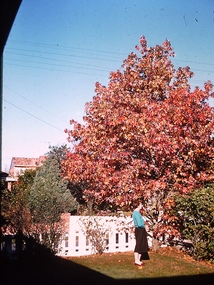 Kew Historical Society Inc
Photograph - Liquid Amber, Ron Setford
Ron Setford and his wife Grace Setford lived in Tanner Avenue, East Kew, from c.1946 to c.1995. A keen photographer, he recorded the changing face of Kew over a 20 year period. Apart from 30 photographs of built structures and places in Kew dating from 1960 and 1961, 145 of his 35mm colour slides chronicle the development of the Eastern Freeway through the Yarra Valley over a five year period from c.1972 to c.1977. This important collection was donated to the Society by his granddaughter in 2025.This collection of 175 35mm slides is of local and statewide significance, owing to its subject matter, particularly the major development of road transport infrastructure during the 1970s with the construction of the Eastern Freeway. The photographer also took care to annotate and date most of his slides which enable the researcher to pinpoint temporal and spatial locations.Nilron setford, gardens. - kew (vic.) -
 Ballarat Heritage Services
Photograph - School, Australia outlined in stone at the site of the Former Dry Diggings State School, 2004, 05/08/2004
This school opened as a common school in 1871 and was originally called Dry Diggings and it replaced Dry Diggings School (No.725), which closed in 1869. The first head teacher was Henry Humffray. There were 40 students when the school opened. The timber schoolhouse had a shingle roof and pine floor. It had been moved from Dry Diggings School. There were 77 students at the school in 1873. A house was built for the teacher in 1874. It had 4 rooms, a veranda, and a shingle roof. The school became a state school at some stage between 1873 and 1878.Four colour photographs showing a carved Australia into rock in the former Dry Diggings Primary School playground.dry diggings, education, schools, dry diggings state school, australia, rock art, henry humffray -
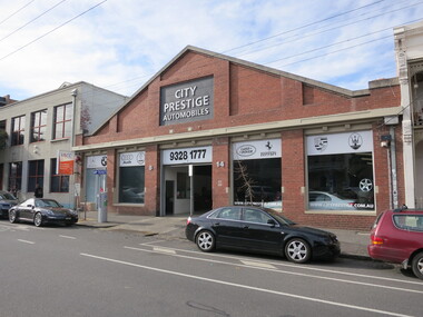 Melbourne Tram Museum
Photograph - Digtial image, Geoff Brown, Howard St North Melbourne - a cable tram car house or depot, June 2017
Set of 7 images of the last built (1925) cable tram car house or depot in Howard St North Melbourne. This building replaced the Flemington Road car house when the cable tram track in Flemington Road was electrified during July 1925. The building is on the Heritage Register - see reference. When closed in 1935, it was subsequently sold to a furniture company. In 2017 it was occupied by City Prestige Automobiles. During 2025, part of the building is occupied by a coffee shop - Le Bajo Milkbar. Photos by Geoff Brown June 2017 and Jan. 2025.Yields information about the Howard St cable car house. Set of 7 digital images of 8-10 Howard St North Melbournem&mtb, howard st, cable trams, car houses, depots -
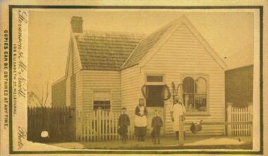 Bacchus Marsh & District Historical Society
Photograph, Thomas Heath's Saddlery Main Street Bacchus Marsh 1883 Image 1
Thomas Heath built this shop for his saddlery business around 1875. In 1926 after 58 years operating his saddlery in Bacchus Marsh he retired and the assets of his business were sold in a clearing sale. The building was located close to the current day location of 192 Main Street and has been demolished. Apart from his services in saddlery his premises was known to be a gathering place for much discussion. Heath was known to openly express his political opinions and his saddlery premises was known by many in the community as the 'Parliament'.Small sepia unframed photograph on card with gold border framing photograph. Housed in the album, 'Photographs of Bacchus Marsh and District in 1883 by Stevenson and McNicoll'. The photo is of a double-fronted weatherboard building with a shingle roof. The front gabled section stands directly on street level and is flanked by a picket fence. The door and overhead window and the side window with arched panels may indicate that this was the shop section, with a dwelling to the rear. Items which may be for sale can be seen hanging in the windows. The recessed side section of the building with a twelve-sectioned window, chimney and a back extension was probably the dwelling used by the family. On the footpath stands the saddler with three children, two boys and an older girl, probably Mr Thomas Heath and three of his five children. A hitching rail runs along the front of the workshop. Indicating the type of business Mr Heath ran, are a saddle placed over the rail and two horse collars and reins hanging either side of the workshop door. On the front: Stevenson & McNicoll. Photo. 108 Elizabeth St. Melbourne. COPIES CAN BE OBTAINED AT ANY TIME. On the back: LIGHT & TRUTH inscribed on a banner surmounted by a representation of the rising sun. Copies of this Portrait can be had at any time by sending the Name and Post Office Money Order or Stamps for the amount of order to STEVENSON & McNICOLL LATE BENSON & STEVENSON, Photographers. 108 Elizabeth Street, MELBOURNE. saddleries, saddlers, thomas heath 1842-1930 saddler -
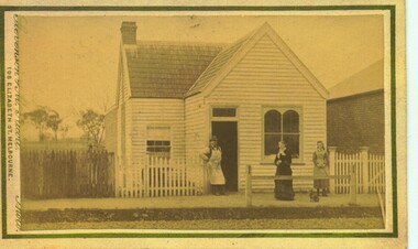 Bacchus Marsh & District Historical Society
Photograph, Thomas Heath's Saddlery Main Street Bacchus Marsh 1883 Image 2
Thomas Heath built this shop for his saddlery business around 1875. In 1926 after 58 years operating his saddlery in Bacchus Marsh he retired and the assets of his business were sold in a clearing sale. The building was located close to the current day location of 192 Main Street and has been demolished. Apart from his services in saddlery his premises was known to be a gathering place for much discussion. Heath was known to openly express his political opinions and his saddlery premises was known by many in the community as the 'Parliament'.Small sepia unframed photograph on card with gold border framing photograph. Housed in the album, 'Photographs of Bacchus Marsh and District in 1883 by Stevenson and McNicoll'. The photo is of a double-fronted weatherboard building with a shingle roof. The front gabled section stands directly on street level and is flanked by a picket fence. The door and overhead window and the side window with arched panels may indicate that this was the shop section, with a dwelling to the rear. The recessed side section of the building with a twelve-sectioned window, chimney and a back extension was probably the dwelling used by the family. In the doorway stands the saddler, probably Thomas Heath. To his left is a woman, possibly Mrs Heath, and a much younger woman, possibly a daughter of the Heaths. In front of the two women is a small dog. A hitching rail runs along the front of the workshop. Indicating the type of business Mr Heath ran. On the front: Stevenson & McNicoll. Photo. 108 Elizabeth St. Melbourne. COPIES CAN BE OBTAINED AT ANY TIME. On the back: LIGHT & TRUTH inscribed on a banner surmounted by a representation of the rising sun. Copies of this Portrait can be had at any time by sending the Name and Post Office Money Order or Stamps for the amount of order to STEVENSON & McNICOLL LATE BENSON & STEVENSON, Photographers. 108 Elizabeth Street, MELBOURNE. saddleries, saddlers, thomas heath 1842-1930 saddler, heath family bacchus marsh, stevenson and mcnicoll 1883 photographs of bacchus marsh and district -
 Glen Eira Historical Society
Album - Photograph Album, Beauville Estate Album, 2001
Originally labelled "Beauville Estate, Established 1936, Still Thriving 65 years on, 10th March 2001", the Beauville Estate Album contains colour photographs of houses in the Estate. They were taken around the time of the Beauville Estate’s 65th Heritage Celebration held on 10/03/2001 and donated to the Caulfield Historical Society shortly afterwards. Photographer Bev Baxter. Glen Eira’s Heritage Management Plan by Andrew Ward (1996) Vol 2 p78 states that by the end of 1934, the first 3 houses had been built in this housing estate.City of Glen Eira’s Heritage Management Plan Vol 2 p79 (p84 of the pdf version) – HO12 Beauville Estate and environs, Murrumbeena: The Beauville Historic Area is important at the State level as the first large housing estate undertaken by the AV Jennings Construction Co, later Jennings Group Limited, Victoria’s largest home builder. It is important also as a very early estate development incorporating a range of features other than houses and including made roads, shops and recreation facilities. In this respect it was the forerunner of the comprehensively planned housing estate of the post war era. The estate is distinguished by its aesthetic values, as is the earlier and comparable Hillcrest Estate, which are formed by a combination of restrained diversity in house styles, with the exception of no. 30 in the emerging International style, and by a landscaped garden environment.Colour photographs of house exteriors, as well as parks and tennis courts on the Beauville Estate. murrumbeena, houses, beauville avenue, architectural styles, 1930's, inter war style, a.v. jennings, av jennings, jennings, brick houses, beauville estate, murrumbeena road, lindsay avenue, gloucester court, dalny road, a v jennings construction co, beauville estate heritage area, glen eira city council, architectural features, plans, shops, residential development, tennis courts, housing estates, builders, building regulations, local government, commercial development, history, maps, photographs, commercial establishments, jennings group limited, land subdivision, gardens, beauville historic area, sir albert victor jennings -
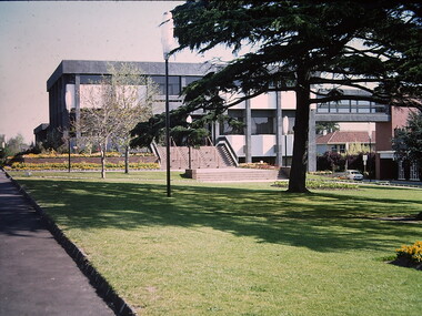
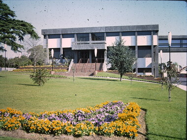
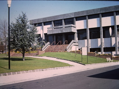
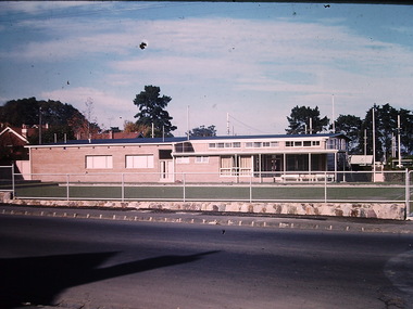
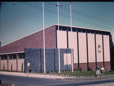
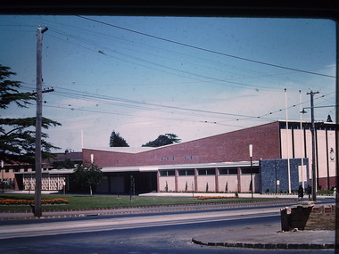 Kew Historical Society Inc
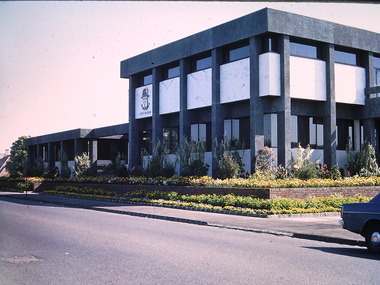
Photograph - Kew City Hall, Ron Setford, 1960
Ron Setford and his wife Grace Setford lived in Tanner Avenue, East Kew, from c.1946 to c.1995. A keen photographer, he recorded the changing face of Kew over a 20 year period. Apart from 30 photographs of built structures and places in Kew dating from 1960 and 1961, 145 of his 35mm colour slides chronicle the development of the Eastern Freeway through the Yarra Valley over a five year period from c.1972 to c.1977. This important collection was donated to the Society by his granddaughter in 2025.This collection of 175 35mm slides is of local and statewide significance, owing to its subject matter, particularly the major development of road transport infrastructure during the 1970s with the construction of the Eastern Freeway. The photographer also took care to annotate and date most of his slides which enable the researcher to pinpoint temporal and spatial locations.The Kew City Hall in Cotham Road, designed by Harold Bartlett, was intended as the initial phase in a scheme to develop an entire civic precinct. This was representative of a widely-held belief, of the immediate post-war era, that a district's civic centre should be precisely that – not just a single grand building for official use, but a dedicated precinct providing a range of community facilities as well as an administrative function. The Kew masterplan was later abandoned. The City Hall was designed to cater for public or official functions. Its interior had a small stage at one end for intimate theatrical productions, a larger stage at the other (with sunken orchestra pit) for musical performances, plus the most up-to-date equipment for live TV transmission."Kew Town Hall"ron setford, photographs -- kew (vic.) -- 1960s, kew town hall -
 Kew Historical Society Inc
Photograph - Kew City Hall, Ron Setford, 1960
Ron Setford and his wife Grace Setford lived in Tanner Avenue, East Kew, from c.1946 to c.1995. A keen photographer, he recorded the changing face of Kew over a 20 year period. Apart from 30 photographs of built structures and places in Kew dating from 1960 and 1961, 145 of his 35mm colour slides chronicle the development of the Eastern Freeway through the Yarra Valley over a five year period from c.1972 to c.1977. This important collection was donated to the Society by his granddaughter in 2025.This collection of 175 35mm slides is of local and statewide significance, owing to its subject matter, particularly the major development of road transport infrastructure during the 1970s with the construction of the Eastern Freeway. The photographer also took care to annotate and date most of his slides which enable the researcher to pinpoint temporal and spatial locations.The Kew City Hall in Cotham Road, designed by Harold Bartlett, was intended as the initial phase in a scheme to develop an entire civic precinct. This was representative of a widely-held belief, of the immediate post-war era, that a district's civic centre should be precisely that – not just a single grand building for official use, but a dedicated precinct providing a range of community facilities as well as an administrative function. The Kew masterplan was later abandoned. The City Hall was designed to cater for public or official functions. Its interior had a small stage at one end for intimate theatrical productions, a larger stage at the other (with sunken orchestra pit) for musical performances, plus the most up-to-date equipment for live TV transmission.Nilron setford, photographs -- kew (vic.) -- 1960s, kew town hall -
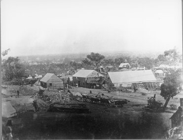 Stawell Historical Society Inc
Photograph, First known photograph of The Reefs and Reef Hotel Pleasant Creek with a bullock team in front 1858 -1861
B/W Photo The Reefs Hotel and Assembly Hall Pleasant Creek with Bullock team in front. 1858 -1861 Three windlasses over mineshafts can be seen, two on the left and one in front of the assembly hall. Some horse driven Whims can be seen in the background above the Assembly Hall. This hotel was built right among the mines in upper Main Street. The first licence was held by William Pond in 1858. Robert Young in 1859 and John Steele in 1861. It had a short life as only rates were paid in 1862.Earliest known photograph of the Reefs Pleasant Creek.Several buildings in mining area with trees in background, one building labelled The Reefs Hotel. Spoil heaps in foreground with other mining activities and with bullock team and cart. Man can be seen standing on slab hut roof at centre and woman in street. stawell, hotel -
 Kew Historical Society Inc
Photograph - Country Roads Board, Ron Setford, 1961
Ron Setford and his wife Grace Setford lived in Tanner Avenue, East Kew, from c.1946 to c.1995. A keen photographer, he recorded the changing face of Kew over a 20 year period. Apart from 30 photographs of built structures and places in Kew dating from 1960 and 1961, 145 of his 35mm colour slides chronicle the development of the Eastern Freeway through the Yarra Valley over a five year period from c.1972 to c.1977. This important collection was donated to the Society by his granddaughter in 2025.This collection of 175 35mm slides is of local and statewide significance, owing to its subject matter, particularly the major development of road transport infrastructure during the 1970s with the construction of the Eastern Freeway. The photographer also took care to annotate and date most of his slides which enable the researcher to pinpoint temporal and spatial locations.Nilron setford, photographs -- kew (vic.) -- 1960s, country roads board, vicroads, denmark street -- kew (vic.) -
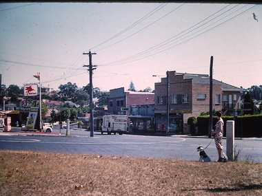 Kew Historical Society Inc
Photograph - North Kew Village, Ron Setford, 1960
Ron Setford and his wife Grace Setford lived in Tanner Avenue, East Kew, from c.1946 to c.1995. A keen photographer, he recorded the changing face of Kew over a 20 year period. Apart from 30 photographs of built structures and places in Kew dating from 1960 and 1961, 145 of his 35mm colour slides chronicle the development of the Eastern Freeway through the Yarra Valley over a five year period from c.1972 to c.1977. This important collection was donated to the Society by his granddaughter in 2025.This collection of 175 35mm slides is of local and statewide significance, owing to its subject matter, particularly the major development of road transport infrastructure during the 1970s with the construction of the Eastern Freeway. The photographer also took care to annotate and date most of his slides which enable the researcher to pinpoint temporal and spatial locations."Nth Kew Village"ron setford, photographs -- kew (vic.) -- 1960s, north kew village, willsmere village -
 Kew Historical Society Inc
Photograph - St Paul's Church, Kew East, Ron Setford, 1961
Ron Setford and his wife Grace Setford lived in Tanner Avenue, East Kew, from c.1946 to c.1995. A keen photographer, he recorded the changing face of Kew over a 20 year period. Apart from 30 photographs of built structures and places in Kew dating from 1960 and 1961, 145 of his 35mm colour slides chronicle the development of the Eastern Freeway through the Yarra Valley over a five year period from c.1972 to c.1977. This important collection was donated to the Society by his granddaughter in 2025.This collection of 175 35mm slides is of local and statewide significance, owing to its subject matter, particularly the major development of road transport infrastructure during the 1970s with the construction of the Eastern Freeway. The photographer also took care to annotate and date most of his slides which enable the researcher to pinpoint temporal and spatial locations.Nilron setford, photographs -- kew (vic.) -- 1960s, st paul's church -- kew east (vic.) -
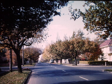 Kew Historical Society Inc
Photograph - Mont Albert Road, Ron Setford, 1961
Ron Setford and his wife Grace Setford lived in Tanner Avenue, East Kew, from c.1946 to c.1995. A keen photographer, he recorded the changing face of Kew over a 20 year period. Apart from 30 photographs of built structures and places in Kew dating from 1960 and 1961, 145 of his 35mm colour slides chronicle the development of the Eastern Freeway through the Yarra Valley over a five year period from c.1972 to c.1977. This important collection was donated to the Society by his granddaughter in 2025.This collection of 175 35mm slides is of local and statewide significance, owing to its subject matter, particularly the major development of road transport infrastructure during the 1970s with the construction of the Eastern Freeway. The photographer also took care to annotate and date most of his slides which enable the researcher to pinpoint temporal and spatial locations."Mont Albert Rd"ron setford, photographs -- kew (vic.) -- 1960s, mont albert road -
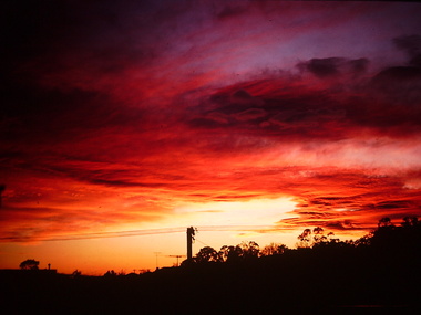 Kew Historical Society Inc
Photograph - Sunrise over Kew East, Ron Setford, 1969
Ron Setford and his wife Grace Setford lived in Tanner Avenue, East Kew, from c.1946 to c.1995. A keen photographer, he recorded the changing face of Kew over a 20 year period. Apart from 30 photographs of built structures and places in Kew dating from 1960 and 1961, 145 of his 35mm colour slides chronicle the development of the Eastern Freeway through the Yarra Valley over a five year period from c.1972 to c.1977. This important collection was donated to the Society by his granddaughter in 2025.This collection of 175 35mm slides is of local and statewide significance, owing to its subject matter, particularly the major development of road transport infrastructure during the 1970s with the construction of the Eastern Freeway. The photographer also took care to annotate and date most of his slides which enable the researcher to pinpoint temporal and spatial locations."Sunrise over East Kew [Aug69}"ron setford, photographs -- kew (vic.) -- 1960s, kew east -
 Kew Historical Society Inc
Photograph - Banool Avenue, Kew, Ron Setford, 1961
Ron Setford and his wife Grace Setford lived in Tanner Avenue, East Kew, from c.1946 to c.1995. A keen photographer, he recorded the changing face of Kew over a 20 year period. Apart from 30 photographs of built structures and places in Kew dating from 1960 and 1961, 145 of his 35mm colour slides chronicle the development of the Eastern Freeway through the Yarra Valley over a five year period from c.1972 to c.1977. This important collection was donated to the Society by his granddaughter in 2025.This collection of 175 35mm slides is of local and statewide significance, owing to its subject matter, particularly the major development of road transport infrastructure during the 1970s with the construction of the Eastern Freeway. The photographer also took care to annotate and date most of his slides which enable the researcher to pinpoint temporal and spatial locations.Nilron setford, photographs -- kew (vic.) -- 1960s, banool avenue -- kew (vic.) -
 Kew Historical Society Inc
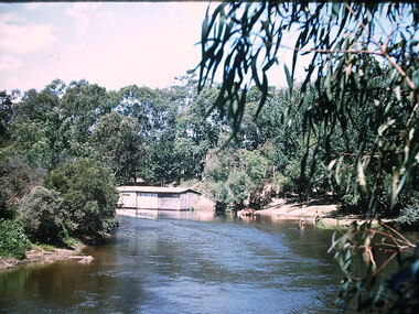
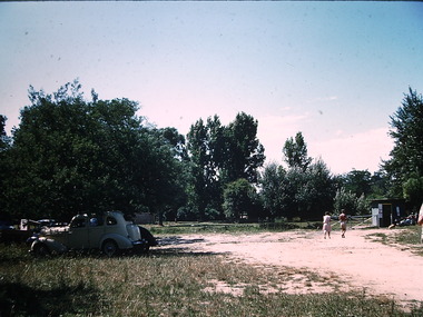
Photograph - Chipperfield's floating 'Pontoon' on the Yarra River, Ron Setford, 1960
Ron Setford and his wife Grace Setford lived in Tanner Avenue, East Kew, from c.1946 to c.1995. A keen photographer, he recorded the changing face of Kew over a 20 year period. Apart from 30 photographs of built structures and places in Kew dating from 1960 and 1961, 145 of his 35mm colour slides chronicle the development of the Eastern Freeway through the Yarra Valley over a five year period from c.1972 to c.1977. This important collection was donated to the Society by his granddaughter in 2025.This collection of 175 35mm slides is of local and statewide significance, owing to its subject matter, particularly the major development of road transport infrastructure during the 1970s with the construction of the Eastern Freeway. The photographer also took care to annotate and date most of his slides which enable the researcher to pinpoint temporal and spatial locations.Nilron setford, photographs -- kew (vic.) -- 1960s, yarra river -- kew east (vic.), chipperfield's boat house, chipperfield's floating pontoon -
 Kew Historical Society Inc
Photograph - Beach near Chipperfield's floating 'Pontoon', Ron Setford, 1960
Ron Setford and his wife Grace Setford lived in Tanner Avenue, East Kew, from c.1946 to c.1995. A keen photographer, he recorded the changing face of Kew over a 20 year period. Apart from 30 photographs of built structures and places in Kew dating from 1960 and 1961, 145 of his 35mm colour slides chronicle the development of the Eastern Freeway through the Yarra Valley over a five year period from c.1972 to c.1977. This important collection was donated to the Society by his granddaughter in 2025.This collection of 175 35mm slides is of local and statewide significance, owing to its subject matter, particularly the major development of road transport infrastructure during the 1970s with the construction of the Eastern Freeway. The photographer also took care to annotate and date most of his slides which enable the researcher to pinpoint temporal and spatial locations.Nilron setford, photographs -- kew (vic.) -- 1960s, yarra river -- kew east (vic.), chipperfield's boat house, chipperfield's floating pontoon -
 Kew Historical Society Inc
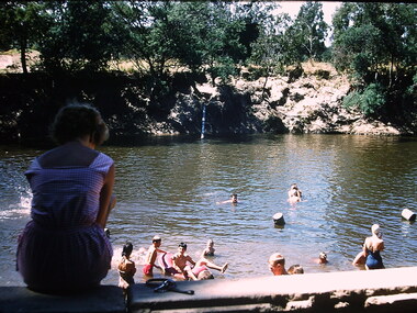
Photograph - Swimming in the Yarra River, Ron Setford, 1960-61
Ron Setford and his wife Grace Setford lived in Tanner Avenue, East Kew, from c.1946 to c.1995. A keen photographer, he recorded the changing face of Kew over a 20 year period. Apart from 30 photographs of built structures and places in Kew dating from 1960 and 1961, 145 of his 35mm colour slides chronicle the development of the Eastern Freeway through the Yarra Valley over a five year period from c.1972 to c.1977. This important collection was donated to the Society by his granddaughter in 2025.This collection of 175 35mm slides is of local and statewide significance, owing to its subject matter, particularly the major development of road transport infrastructure during the 1970s with the construction of the Eastern Freeway. The photographer also took care to annotate and date most of his slides which enable the researcher to pinpoint temporal and spatial locations.Nilron setford, photographs -- kew (vic.) -- 1960s, yarra river, recreation -- river swimming