Showing 984 items matching " jetties"
-
 Lakes Entrance Historical Society
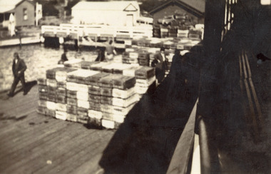
Photograph - Fishing Industry, Jemmeson, Edie, 1927 c
... Jetties ...Black and white photograph of boxes of fish on Harbecks Wharf, Eastern Wharf, to be transported to Melbourne for the Good Friday market. Lakes Entrance Victoriafishing industry, fish, jetties, commerce -
 Lakes Entrance Historical Society
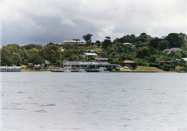
Photograph - Bancroft Bay, 1994 c
... Jetties ...Metung originally named RoshervilleColour photograph taken from Bancroft Bay, showing the Metung Hotel, three of Bull's cruisers at waters edge, Powerlot residence on hill top, other residences on hill side. Metung Victoriawaterfront, hotels, jetties, boats and boating -
 Lakes Entrance Historical Society
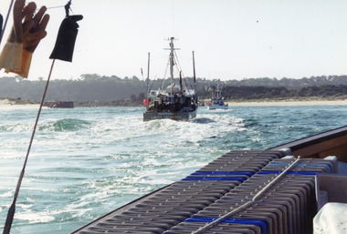
Photograph - Sylvia, Hammarstrom Ian, 1987 c
... Jetties ...Colour photograph of the fishing boat Sylvia which has just left Cunninghame Arm and is heading into the entrance channel on way to fishing grounds off Lakes Entrance, Victoria.ships and shipping, fishing industry, waterways, jetties -
 Lakes Entrance Historical Society
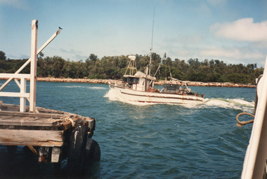
Photograph - Tarpeena, Hammarstrom Ian, 1985 c
... Jetties ...Colour photograph of fishing boats approaching the entrance channel from Bass Strait, taken from deck of Minawie, shows Tarpeena crossing bar and Nungurner entering the channel. Lakes Entrance Victoriaships and shipping, jetties, fishing industry, waterfront -
 Lakes Entrance Historical Society
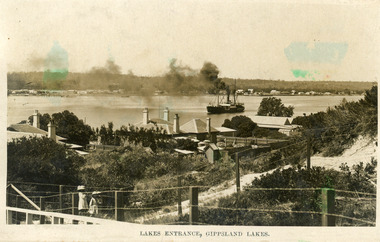
Photograph - Entrance Piers, 1905c
... Jetties ...Note on back - Dear Aggie, Met mother Friday evening, train arrived in Melbourne between 6 & 7. Jessie.Colour photograph showing early view of new wooden piers, a few people on pier and on beach. Strand of barbed wire across foreground. Lakes Entrance VictoriaCunninghame, Victoriaboardwalk, jetties, ocean, public works -
 Lakes Entrance Historical Society
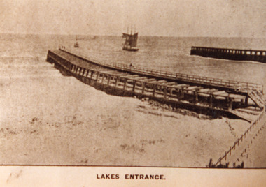
Photograph - Entrance Piers, 1890c
... Jetties ...Sepia photograph showing entrance from ocean Bass Strait to Gippsland Lakes. Early wooden piers, trading ship being towed out through entrance by small steamer, beach and boardwalk in foreground. Lakes Entrance VictoriaLakes Entrancejetties, ocean, waterways, public works -
 Lakes Entrance Historical Society
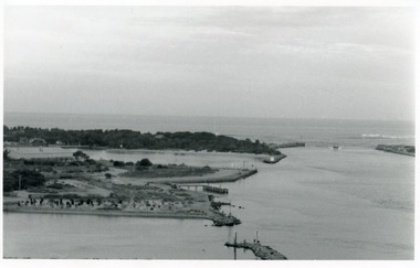
Photograph - The Entrance, Goff, Russell, 1986c
... Jetties ...Black and white photograph of the entrance and Bullock Island showing the western end of Bullock Island formed by successive dumping of dredged sand. Lakes Entrance Victoriajetties, ocean, waterways, islands -
 Lakes Entrance Historical Society
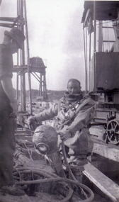
Photograph, 1915c
... Jetties ...Black and white photograph showing man in diving suit, holding diving helmet, machinery on tram lines, second man on left of photo at Lakes Entrance, Victoria.waterways, jetties, public works, divers -
 Lakes Entrance Historical Society
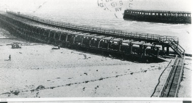
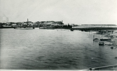
Photograph - The Entrance, 1885c
... Jetties ...Also two identical copies|Also one 9 x 13 potograph in spares boxBlack and white photograph showing building of the entrance piers. Works building and houses on dunes at left, partially built pier on right background. Wombat dredge in centre. Lakes Entrance Victoriajetties, waterways, public works, historic buildings -
 Lakes Entrance Historical Society
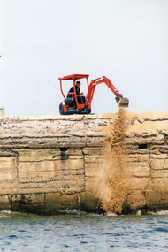
Photograph, Lakes Post Newspaper, 1999c
... Jetties ...Colour photograph showing workman using digging machine to remove sand from inside entrance pier at Lakes Entrance Victoria.waterways, jetties, machinery, public works -
 Lakes Entrance Historical Society
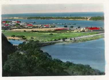
Postcard - Lakes Entrance, The Rose Series, 1975
... Jetties ...Sand dumping has commenced in preparation of works to modify and deepen Cunninghame Arm|Also one other copyColour postcard of the view of Cunninghame Arm, Lakes Entrance, from the Glenara Tower. Shows the western boat harbour with private cruisers and professional fishing vessels moored at wharf. Lakes Entrance Victoriawaterways, boats and boating, jetties, waterfront -
 Lakes Entrance Historical Society
Photograph - Boat Harbour Lakes Entrance, 1980
... Jetties ...Colour photograph of an unknown scallop fishing boat entering the boat harbour, one man in wheel house, another man standing on deck. Lakes Entrance Victoriaboats and boating, fishing industry, waterways, jetties -
 Lakes Entrance Historical Society
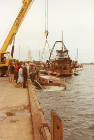
Photograph - Idler, 1980
... Jetties ...Colour photograph of the recovery of the cruiser Idler which had been abandoned at sea fishing industry, boats and boating, disasters, jetties -
 Lakes Entrance Historical Society
Postcard - Township, 1998c
... Jetties ...Tinted small format postcard showing the township situated on the isthmus between two stretches of water the Cunninghame Arm and the North Arm. Work in progress widening the North Arm Bridge as seen by workmen's huts beside the southern approach. Lakes Entrance Victoriajetties, waterways, topography, township -
 Lakes Entrance Historical Society
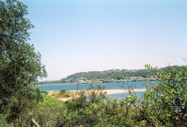
Photograph - Lakes Entrance, Davies, Judy, 2005c
... Jetties ...Colour photograph of Jemmys Point, Kalimna Heights, and the Western end of the township, taken from the southern shore of Cunninghame Arm. Small sand spit and natural vegetation in foreground. Lakes Entrance Victoriajetties, waterways, topography, township -
 Lakes Entrance Historical Society
Postcard - Bullock Island, Bulmer H D, 1920c
... Jetties ...Hand coloured postcard of Bullock Island and the man made entrance from Bass Strait to the Gippsland Lakes. Also shown the small township, unofficially known as Carpentertown at the entrance works. Photo taken from Kalimna Hill, shrubbery in foreground. Lakes Entrance VictoriaBullock Island, Lakes Entrancewaterways, bridges, islands, jetties -
 Lakes Entrance Historical Society
Photograph - New Works, 1905c
... Jetties ...Also black and white copy 10 x 16.5|Also sepia toned postcard damagedBlack and white photograph showing view from New Works across lake, and Cunninghame Arm. Foreground shows two children on boardwalk, roofs of harbour masters and harbour engineers houses, and the house of the contractor John Carpenter. Smoke billowing from funnel of S S Wyralla. Lakes Entrance Victoriajetties, waterways, township, topography -
 Lakes Entrance Historical Society
Photograph - Eclipse, 1923
... Jetties ...Note Walings are completeBlack and white photograph showing passenger boat, Eclipse near walings on west side of entrance, six people on board, small boats against walings, crane on end. Lakes Entrance Victoriawaterways, jetties, boats and boating, tourism -
 Lakes Entrance Historical Society
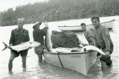
Photograph, 1950c
... Jetties ...Black and white photograph of four men showing their catch of king fish from their lake boat in the Pambula River, NSWfishing industry, boats and boating, fish, jetties -
 Lakes Entrance Historical Society
Photograph, 1908
... Jetties ...Also black and white copy 12 x 18 cmSepia photograph showing launching of the S S Gippsland, entering water at slipway, bunting flying from mast, some people onboard. Small motor vessel right foreground, Raymond Island in background, hull painted white. Paynesville Victoriajetties, waterways, ships and shipping, launching -
 Lakes Entrance Historical Society
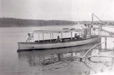
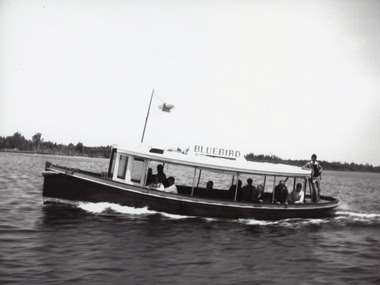
Photograph - Bluebird, 1955c
... Jetties ...The Bluebird plied Lakes for years until replaced by Peel's StormbirdBlack and white photograph showing launch Bluebird II on Gippsland Lakes. Ten people onboard. Sand hummocks in background. Lakes Entrance Victoriajetties, waterways, boats and boating, tourism -
 Lakes Entrance Historical Society
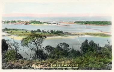
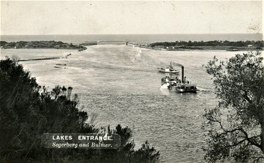
Photograph - The Entrance, Segerberg and Bulmer, 1910 c
... Jetties ...Also enlargement 17 x 23 cmBlack and white photograph showing view from Jemmys Point of the entrance to the Gippsland Lakes from Bass Strait. Pioneer dredge in centre foreground, and steamer JCD. Cottages and works buildings including Rocket shed on eastern dunes, Schnapper Cottage on far right western dune. Rock groynes and tip of Bullock Island centre left. Vegetation in foreground. Lakes Entrance VictoriaLAKES ENTRANCE Segerberg and Bulmerships and shipping, topography, jetties, houses -
 Lakes Entrance Historical Society
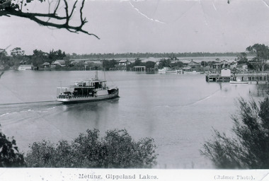
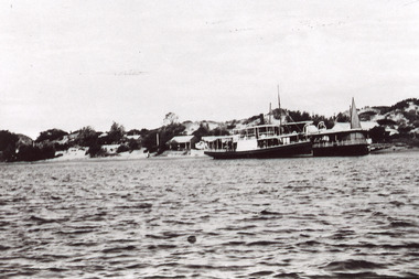
Photograph - S.S. Omeo, Bulmer H D, 1910 c
... Jetties ...Black and white photograph showing steamer S S Omeo approaching Metung, on Bancroft Bay, Village of Metung with Metung wharf and shed on right, Shaving Point on far left. Log cabin in Bull's Shipyard visible behind wharf, Lake King and Boole Poole Peninsula visible behind Metung Village. Metung Victoria.Metung, Gipplsand Lakes (Bulmer photo)ships and shipping, waterways, jetties, township -
 Lakes Entrance Historical Society
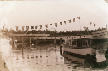
Photograph - New Works Jetty, 1920 c
... Jetties ...Also one black and white copy of the same image.Black and white photograph showing two steamers at New Works wharf, Cunninghame Arm,Cottages on dune behind steamers. Top of sail visible behind steamer. Sand showing between vegetation on dunes. Lakes Entrance Victoria.ships and shipping, waterways, jetties, islands -
 Lakes Entrance Historical Society
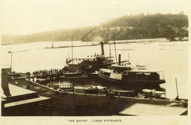
Photograph - New Works Jetty, 1910 c
... Jetties ...Black and white photograph showing two steamers at New Works wharf, five or six other smaller vessels and crowds of people on wharf and steamers. Small shed on end of wharf, rooves of two buildings in foreground. Jemmys Point hill in the background and timber barrier wall for formation of Bullock Island. Lakes Entrance Victoria.The Wharf, Lakes Entranceships and shipping, waterways, jetties, people -
 Lakes Entrance Historical Society
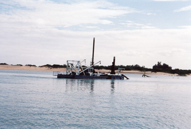
Photograph - Sandpiper, 2000 c
... Jetties ...Wooden stocked anchor was dredged up in April 2004, off Rigby Island, Lakes Entrance, Victoria.Colour photograph showing lakes dredge Sandpiper off Rigby Island, Lakes Entrance, Victoria.dredging, jetties, waterways, islands -
 Lakes Entrance Historical Society
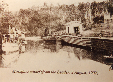
Photograph - Mossiface Wharf, Mossiface wharf at Mossiface Victoria 1902, 1902
... Jetties ...Sepia photograph showing S S Lady Harriet and barge at Mossiface wharf on Tambo river near Bruthen, Lady Harriet on left barge on right at wharf store shed and crane on wharf, small building far right, forested hill at back, stern of small rowing boat at lower right in photograph. Mossiface Victoria 1902Mossiface wharf (from the Leader, 2 August 1902)jetties, transport, ships and shipping, rivers -
 Lakes Entrance Historical Society
Book, Ports and Harbours, 1920c|1960c
... Jetties ...A collection of photocopied letters from towards correspondence files for Ports and Harbours Lakes Entrance Victoriajetties, waterways, dredging, quarries -
 Lakes Entrance Historical Society
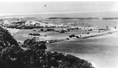
Postcard, Bulmer H D, North Arm concrete bridge, Lakes Entrance Victoria c1950, 1950c
... Jetties ...Township of Lakes Entrance Black and white photograph of view from Kalimna Heights, showing part of the North Arm concrete bridge, Bullock Island and western side of entrance. Truck parked on approach to bridge. Lakes Entrance Victoriatownship, jetties, islands, hotels -
 Lakes Entrance Historical Society
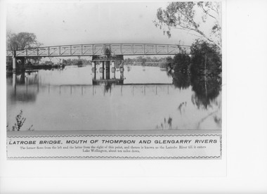
Photograph, Caire, Nicholas John, Swing Bridge Sale Victoria, 1905c
... Jetties ...turning on a central axis to allow the passage of river vessels. Image shows machinery for operation and the bridge closed to river traffic. Latrobe Wharf on the left bank is seen through bridge. Sale VictoriaBlack and white photograph of the Latrobe Bridge. This was a swing bridge over the Latrobe Riverbridges, waterways, civil engineering, jetties