Showing 1778 items
matching maps and plans
-
 Bacchus Marsh & District Historical Society
Map, Lerderderg District Proposed Irrigation and Water Supply Trust (A). Plan showing boundaries of Trust District
The 1886 Irrigation Act in Victoria introduced the first legislation in Australia designed to enable the creation of a detailed scheme for agricultural irrigation. Part of the legislation saw the use of government funds for local irrigation projects. These local projects were managed by local irrigation trusts. The Lerderderg Irrigation and Water Supply Trust] was formed in 1890. This map depicts the proposed area of the Trust.Printed paper map of the proposed Lerderderg District Irrigation and Water Supply. Plan showing boundaries of Trust District. The Lerderderg District lies within the Parishes of Korkuperrumul and Merrimu in the County of Bourke. At the top of the map above its title is the letter 'A; in capital lettering. Scale: 40 Chains = 1 inch.irrigation, water supply, lerderderg irrigation and water supply trust -
 Tatura Irrigation & Wartime Camps Museum
Folder, Karlsruhe, 1987
History of "Karlsruhe" homestead on Nation Trust of historical homes built by Baon Von Swaine. Also plans maps, photographs. Tape of official opening 1986Black and white mottled binder, contains newspaper articles on renovation of Karlsruhekarlsruhe homestead, lancaster, baron von swaine, tatura, documents, history, local, newspapers -
Stawell Historical Society Inc
Book - Report, Grampians: A Report on recreation and Timber Uses of. Too Steep to Graze - Too Rocky to Plough, 1979
1) Conservation & Economics 2) Grampians Study Area 3) Land Use 4) Management 5) Criticisms of the Management Plan Appendix Graphs & MapsGreen Paper cover: Black tape on SpineConservation council of Victoria and Logo -
 Whitehorse Historical Society Inc.
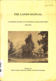
Manual - Government (Lands Dept), Royal Historical Society of Victoria, The Lands Manual - A Finding Guide to Victorian Land Records 1836 - 1983, March 1989
The manual documents the archives of the Department of Crown Lands and Survey (Lands Department) between 1836 to 1983 and explains how they can be used for historical research.The manual documents the archives of the Department of Crown Lands and Survey (Lands Department) and explains how they can be used for historical research.The manual documents the archives of the Department of Crown Lands and Survey (Lands Department) between 1836 to 1983 and explains how they can be used for historical research.crown lands, victoria. department of crown lands and survey -
 Bendigo Historical Society Inc.
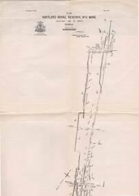
Map - STRUGNELL COLLECTION: HUSTLER'S LINE OF REEFS, BENDIGO, September 1913
Map, Hustler's Line of Reefs, Hustler's Royal Reserve No.2 Mine, Bendigo Plan. Plate No.V1 (6). Bulletin No 33 Signed H.A.Whitelaw Underground survey Office Bendigo September 1913Underground Survey Office, Bendigo.map, bendigo, hustler's royal reserve no. 2 mine* -
Bendigo Historical Society Inc.
Map - CAMPBELL COLLECTION: BENDIGO AND DISTRICT MAPS
Map. Forest Commission Victoria, Bendigo Forest District, Basic information prepared 1982, scale 1:100,000. Fire Prevention Strategy Plan. Mitiamo, Greater Bendigo Area, Castlemaine F.D.map, bendigo, forest district -
Clunes Museum
Map, 1890
... plans ...Features location of Club Hotel, Union Bank, Engine rooms, Port Phillip Hotel, Pyrites furnace, Battery, Office, Smith Shop,Surface Tramway to BatteryPhotocopy of map/plan of Dixon's New North Clunes, Central Clunes Co. and South Clunes utd showing various shafts and pre-emptive rights. Scale 1 inch = 100 feetOn front in red ink; "drawn in 1890"mine shafts, hotels, plans -
 Ringwood and District Historical Society
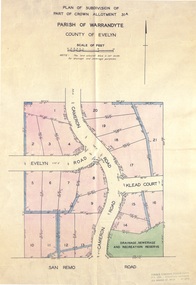
Document - Real Estate Folder, Savernake Estate, Ringwood, Victoria - Stage one - 1967
Plan of Subdivision, Part of Crown Allotment 31A and advertisement for sale of residential allotments with map showing layout of subdivision. Typewritten pricelist attached outlining suggested terms of sale as of 14 September, 1967.Subdivision includes Evelyn Road, Cameron Road, Klead Court, and San Remo Road. Agent - C.E. Carter & Son., 126 Whitehorse Road, Ringwood. (Phone) 87-6024, 87-6830, 870-2519, After hours: 723 3298, 878 2648. Subdivision Plan stamped Donald Cameron Consultants Pty. Ltd., Consulting Engineers, 472 Bourke Street Melbourne - 67-2602. -
 Bendigo Historical Society Inc.
Map - STATE RIVERS AND WATER COMMISSION : COLIBAN DISTRICT IRRIGATION AND TOWN SUPPLY CHANNELS, 30/11/1956
State Rivers and Water Supply Commission. Foolscap-size map. Title : Coliban district Plan showing Irrigation and Town Supply Channels. The map covers the area from Raywood to Guildford. Scale : 1 inch to 4 miles. Dated 30/11/56, number 5,491 in bottom right corner.state infrastructure, water supply, coliban system, state rivers and water supply commission. coliban system. -
Bendigo Historical Society Inc.
Map - CAMPBELL COLLECTION: BENDIGO AND DISTRICT MAPS, 8-6 29
Map. Kimbolton, Parishes of Kimbolton and Lyell, scale 20 chains to 1 inch. Area by Plamimeter 6258 acres. Coliban River, Knowsley, Strathfieldsaye 10 1/2 miles. Prepared in W.P.B. from Parish and Assessor's Plans. G.W.Latimer 8-6-29. (number 393 in map cupboard 1)G.W.Latimermap, bendigo, allotments -
Bendigo Historical Society Inc.
Map - CAMPBELL COLLECTION: BENDIGO AND DISTRICT MAPS, 16-4-29
Map. Kennington, Parishes of Sandhurst, Mandurang and Strathfieldsaye. Scale 20 chains to 1 inch. Total area 2918 acres. Bendigo 2 1/2 miles. Prepared in W.B. from A.and C. L. Plans by W.J. Galbraith, 16-4-29. (number 364 in map cupboard 1)W.J.Galbraithmap, bendigo, allotments -
Bendigo Historical Society Inc.
Map - FRED COWIE COLLECTION: AERIAL MAPS OF HEATHCOTE/EPPALOCK, 28-9-1960
Map, Heathcote C2, Township of Heathcote, Melbourne Road through town branching off to Bendigo & Echuca. Aerial Survey of Victoria. Photo-map prepared by Department of Crown Lands and Survey from photographs taken in 1960. Copied photographically at the Central Plan Office.Fred Cowie,46 McIvor Rd,Bgo..Central Plan Officemap -
 Federation University Historical Collection
Photograph - Photograph and Documents, Anne Beggs Sunter, Latta/Downing Family, Mount Helen
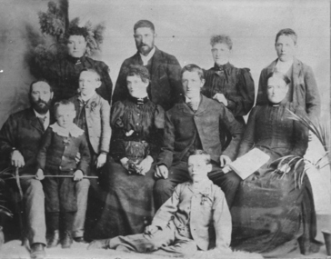
The Federation University Mt Helen Campus was once the farm of John Latta and his wife Elizabeth Ann Dean. The couple married in 1867 and had three children at the time of John Latta's death (Elizabeth Ann b.1870; Mary b.1873; John b.1875). Elizabeth later married George Downing, and had another six children. The house was situated in the vicinity of the current Administration and Caro Conference Centre buildings, surrounded by an orchard, and a well under the current Albert Coates Building (Union Building). The land was purchased by the Ballarat School of Mines for their tertiary division from the Stapleton family.Various items relating to the Federation University Mount Helen Campus, and the early settlers on the land, the Latta Family. .1) Parish Plan, including E. Latta, M. Fiscalini, R. Wynne, R. Nixon, J.U. Smith, J. Davis .2) Part of a 1930s ordinance map showing Ballarat, Buninyong and Greenhill .3) Contour Map with the first two Mt Helen Campus buildings included. .4) Drawing a a proposed campus plan .5) Latta Family negativemount helen campus, latta family, greenhill, e. latta, m. fiscalini, r. wynne, r. nixon, j.u. smith, j. davis, parish plan, john latta, elizabeth latta, george downing, elezabeth downing, green hill, pontresina, abraham baxter, g. dean, market gardens, jim downing, bob thornton, j. hateley, martin fanning, toll keeper, anne beggs sunter -
 Bacchus Marsh & District Historical Society
Map, Gaynor Street Area Land Sales, Maddingley, 1888
This map was produced for a major sale of land in the Maddingley area of Bacchus Marsh in 1888. The sale was conducted by two firms from Melbourne, Carney and Kelly 12 Swanston Street Melbourne. and 'Richardson, Kerr & Co. 40 Flinders Lane Melbourne. 136 blocks were for sale.A single page paper map showing land allotments for sale in the Maddingley area of Bacchus Marsh. Locations shown include Gaynor Street, Maddingley Road South, Parwan Road, Mitchem Street, Typpynge Street, Finn Street and East Maddingley Road. . The map is pasted into a bound volume containing 76 maps or plans in total. High resolution digital image stored on BMDHS computer network. bacchus marsh victoria maps, maddingley victoria maps, land use, maddingley victoria history, land sales bacchus marsh, land sales maddingley -
 Bacchus Marsh & District Historical Society
Map, Gaynor Street Land Sales, Maddingley, circa 1880s-1890s
This map was produced for a major sale of land in the Maddingley area of Bacchus Marsh. The precise date of the sale has not been determined. Features present on the map such as the Bacchus Marsh Railway Station indicate the land sale must have taken place some time after 1887 when the Railway Station opened. A single page paper map showing land allotments for sale in the Maddingley area of Bacchus Marsh. Locations shown include Gaynor Street, Maddingley Road South, Parwan Road, Mitchem Street, Typpynge Street, Finn Street and East Maddingley Road. . The map is pasted into a bound volume containing 76 maps or plans in total. High resolution digital image stored on BMDHS computer network. bacchus marsh victoria maps, maddingley victoria maps, land use, maddingley victoria history, land sales bacchus marsh, land sales maddingley -
 Flagstaff Hill Maritime Museum and Village
Book, The Outline of History Vol 1
This item is from the ‘Pattison Collection’, a collection of books and records that was originally owned by the Warrnambool Mechanics’ Institute, which was founded in Warrnambool in 1853. By 1886 the Warrnambool Mechanics’ Institute (WMI) had grown to have a Library, Museum and Fine Arts Gallery, with a collection of “… choice productions of art, and valuable specimens in almost every branch and many wonderful national curiosities are now to be seen there, including historic relics of the town and district.” It later included a School of Design. Although it was very well patronised, the lack of financial support led the WMI in 1911 to ask the City Council to take it over. In 1935 Ralph Pattison was appointed as City Librarian to establish and organise the Warrnambool Library as it was then called. When the WMI building was pulled down in 1963 a new civic building was erected on the site and the new Warrnambool Library, on behalf of the City Council, took over all the holdings of the WMI. At this time some of the items were separated and identified as the ‘Pattison Collection’, named after Ralph Pattison. Eventually the components of the WMI were distributed from the Warrnambool Library to various places, including the Art Gallery, Historical Society and Flagstaff Hill. Later some were even distributed to other regional branches of Corangamite Regional Library and passed to and fro. It is difficult now to trace just where all of the items have ended up. The books at Flagstaff Hill Maritime Village generally display stamps and markings from Pattison as well as a variety of other institutions including the Mechanics’ Institute itself. RALPH ERIC PATTISON Ralph Eric Pattison was born in Rockhampton, Queensland, in 1891. He married Maude Swan from Warrnambool in 1920 and they set up home in Warrnambool. In 1935 Pattison accepted a position as City Librarian for the Warrnambool City Council. His huge challenge was to make a functional library within two rooms of the Mechanics’ Institute. He tirelessly cleaned, cleared and sorted a disarrayed collection of old books, jars of preserved specimens and other items reserved for exhibition in the city’s museum. He developed and updated the library with a wide variety of books for all tastes, including reference books for students; a difficult task to fulfil during the years following the Depression. He converted all of the lower area of the building into a library, reference room and reading room for members and the public. The books were sorted and stored using a cataloguing and card index system that he had developed himself. He also prepared the upper floor of the building and established the Art Gallery and later the Museum, a place to exhibit the many old relics that had been stored for years for this purpose. One of the treasures he found was a beautiful ancient clock, which he repaired, restored and enjoyed using in his office during the years of his service there. Ralph Pattison was described as “a meticulous gentleman whose punctuality, floorless courtesy and distinctive neat dress were hallmarks of his character, and ‘his’ clock controlled his daily routine, and his opening and closing of the library’s large heavy doors to the minute.” Pattison took leave during 1942 to 1945 to serve in the Royal Australian Navy, Volunteer Reserve as Lieutenant. A few years later he converted one of the Museum’s rooms into a Children’s Library, stocking it with suitable books for the younger generation. This was an instant success. In the 1950’s he had the honour of being appointed to the Victorian Library Board and received more inspiration from the monthly conferences in Melbourne. He was sadly retired in 1959 after over 23 years of service, due to the fact that he had gone over the working age of council officers. However he continued to take a very keen interest in the continual development of the Library until his death in 1969. The Pattison Collection, along with other items at Flagstaff Hill Maritime Village, was originally part of the Warrnambool Mechanics' Institute’s collection. The Warrnambool Mechanics’ Institute Collection is primarily significant in its totality, rather than for the individual objects it contains. Its contents are highly representative of the development of Mechanics' Institute libraries across Australia, particularly Victoria. A diversity of publications and themes has been amassed, and these provide clues to our understanding of the nature of and changes in the reading habits of Victorians from the 1850s to the middle of the 20th century. The collection also highlights the Warrnambool community’s commitment to the Mechanics’ Institute, reading, literacy and learning in the regions, and proves that access to knowledge was not impeded by distance. These items help to provide a more complete picture of our community’s ideals and aspirations. The Warrnambool Mechanics Institute book collection has historical and social significance for its strong association with the Mechanics Institute movement and the important role it played in the intellectual, cultural and social development of people throughout the latter part of the nineteenth century and the early twentieth century. The collection of books is a rare example of an early lending library and its significance is enhanced by the survival of an original collection of many volumes. The Warrnambool Mechanics' Institute’s publication collection is of both local and state significance. The Outline of History Vol 1 Being a Plain History of Life and Mankind with maps & Plans by J. F. Horrabin Author: H G Wells Publisher: Waverley Book Co Ltd Date: 1925Label on spine cover with typed text PAT F 909 WEL Pastedown front endpaper has sticker from Warrnambool Public Library covered by a sticker from Corangamite Regional Library Service Front loose endpaper has a stamp from Corangamite Regional Library Service Fly paper has a stamp from Corangamite Regional Library Servicewarrnambool, shipwrecked-coast, flagstaff-hill, flagstaff-hill-maritime-museum, maritime-museum, shipwreck-coast, flagstaff-hill-maritime-village, shipwrecked-artefact, book, pattison collection, warrnambool library, warrnambool mechanics’ institute, ralph eric pattison, corangamite regional library service, warrnambool city librarian, mechanics’ institute library, victorian library board, warrnambool books and records, warrnambool children’s library, great ocean road, h g wells, the outline of history vol 1 -
 Flagstaff Hill Maritime Museum and Village
Book, The Outline of History Vol 2
This item is from the ‘Pattison Collection’, a collection of books and records that was originally owned by the Warrnambool Mechanics’ Institute, which was founded in Warrnambool in 1853. By 1886 the Warrnambool Mechanics’ Institute (WMI) had grown to have a Library, Museum and Fine Arts Gallery, with a collection of “… choice productions of art, and valuable specimens in almost every branch and many wonderful national curiosities are now to be seen there, including historic relics of the town and district.” It later included a School of Design. Although it was very well patronised, the lack of financial support led the WMI in 1911 to ask the City Council to take it over. In 1935 Ralph Pattison was appointed as City Librarian to establish and organise the Warrnambool Library as it was then called. When the WMI building was pulled down in 1963 a new civic building was erected on the site and the new Warrnambool Library, on behalf of the City Council, took over all the holdings of the WMI. At this time some of the items were separated and identified as the ‘Pattison Collection’, named after Ralph Pattison. Eventually the components of the WMI were distributed from the Warrnambool Library to various places, including the Art Gallery, Historical Society and Flagstaff Hill. Later some were even distributed to other regional branches of Corangamite Regional Library and passed to and fro. It is difficult now to trace just where all of the items have ended up. The books at Flagstaff Hill Maritime Village generally display stamps and markings from Pattison as well as a variety of other institutions including the Mechanics’ Institute itself. RALPH ERIC PATTISON Ralph Eric Pattison was born in Rockhampton, Queensland, in 1891. He married Maude Swan from Warrnambool in 1920 and they set up home in Warrnambool. In 1935 Pattison accepted a position as City Librarian for the Warrnambool City Council. His huge challenge was to make a functional library within two rooms of the Mechanics’ Institute. He tirelessly cleaned, cleared and sorted a disarrayed collection of old books, jars of preserved specimens and other items reserved for exhibition in the city’s museum. He developed and updated the library with a wide variety of books for all tastes, including reference books for students; a difficult task to fulfil during the years following the Depression. He converted all of the lower area of the building into a library, reference room and reading room for members and the public. The books were sorted and stored using a cataloguing and card index system that he had developed himself. He also prepared the upper floor of the building and established the Art Gallery and later the Museum, a place to exhibit the many old relics that had been stored for years for this purpose. One of the treasures he found was a beautiful ancient clock, which he repaired, restored and enjoyed using in his office during the years of his service there. Ralph Pattison was described as “a meticulous gentleman whose punctuality, floorless courtesy and distinctive neat dress were hallmarks of his character, and ‘his’ clock controlled his daily routine, and his opening and closing of the library’s large heavy doors to the minute.” Pattison took leave during 1942 to 1942 to serve in the Royal Australian Navy, Volunteer Reserve as Lieutenant. A few years later he converted one of the Museum’s rooms into a Children’s Library, stocking it with suitable books for the younger generation. This was an instant success. In the 1950’s he had the honour of being appointed to the Victorian Library Board and received more inspiration from the monthly conferences in Melbourne. He was sadly retired in 1959 after over 23 years of service, due to the fact that he had gone over the working age of council officers. However he continued to take a very keen interest in the continual development of the Library until his death in 1969. The Pattison Collection, along with other items at Flagstaff Hill Maritime Village, was originally part of the Warrnambool Mechanics' Institute’s collection. The Warrnambool Mechanics’ Institute Collection is primarily significant in its totality, rather than for the individual objects it contains. Its contents are highly representative of the development of Mechanics' Institute libraries across Australia, particularly Victoria. A diversity of publications and themes has been amassed, and these provide clues to our understanding of the nature of and changes in the reading habits of Victorians from the 1850s to the middle of the 20th century. The collection also highlights the Warrnambool community’s commitment to the Mechanics’ Institute, reading, literacy and learning in the regions, and proves that access to knowledge was not impeded by distance. These items help to provide a more complete picture of our community’s ideals and aspirations. The Warrnambool Mechanics Institute book collection has historical and social significance for its strong association with the Mechanics Institute movement and the important role it played in the intellectual, cultural and social development of people throughout the latter part of the nineteenth century and the early twentieth century. The collection of books is a rare example of an early lending library and its significance is enhanced by the survival of an original collection of many volumes. The Warrnambool Mechanics' Institute’s publication collection is of both local and state significance. The Outline of History Vol 2 Being a Plain History of Life and Mankind Author: H G Wells, with Maps & Plans by J F Horrabin Publisher: The Waverley Book Co Ltd Date: 1925 Label on spine with typed text PAT F 909 WEL Pastedown front endpaper has sticker from Warrnambool Public Library covered by a sticker from Corangamite Regional Library Service Front loose endpaper has a stamp from Corangamite Regional Library Service Fly paper has a stamp from Warrnambool Mechanics Institutewarrnambool, shipwrecked-coast, flagstaff-hill, flagstaff-hill-maritime-museum, maritime-museum, shipwreck-coast, flagstaff-hill-maritime-village, shipwrecked-artefact, book, pattison collection, warrnambool library, warrnambool mechanics’ institute, ralph eric pattison, warrnambool city librarian, mechanics’ institute library, victorian library board, warrnambool books and records, warrnambool children’s library, the outline of history, h g wells -
 Whitehorse Historical Society Inc.
Letter - Correspondence, East Burwood Reserve, 1993
Various documents relating to the establishment of East Burwood ReserveVarious documents relating to the establishment of East Burwood Reserve including acquisition of land, details, plans, locality map, news cuttings and photographs. Appears to be copy of Nunawading City Council File April 1993Various documents relating to the establishment of East Burwood Reserve sportsgrounds, east burwood reserve, soilleur (dr), hitchens, anna, blue moon fruit co-operative ltd., jacobson and logan, king family, central methodist mission, aussat, tally ho, sewart, bill -
Whitehorse Historical Society Inc.
Map, Environment effects statement, 1/03/1979 12:00:00 AM
Diamond Creek-Ringwood study: Planning Scheme reservations and zones with recommended concept.Diamond Creek-Ringwood study: Planning Scheme reservations and zones with recommended concept. City of Nunawading: section north of Canterbury Road. Scale 1:25,000 metric. Map B with drafting ref. no. 145Diamond Creek-Ringwood study: Planning Scheme reservations and zones with recommended concept. city of nunawading, land use, melbourne metropolitan planning scheme -
 Lakes Entrance Historical Society
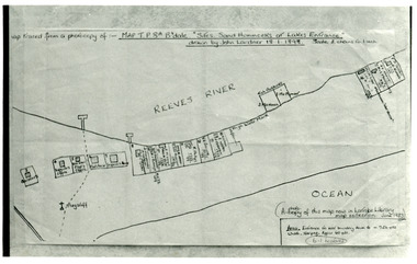
Photograph - New Works Plan, 1898
Map traced from a photocopy of :- Map TP8A Bairnsdale. 'Site. Sand Hummocks of Lakes Entrance'. Drawn by John Lardner 18 January 1898. Scale two chains to one inch. ( A photocopy of this map in Latrobe Library map collection, June 1983)Black and white photograph showing sketch map of 1898 by John Lardner Plan of Sites - sand hummocks. Drawing shows sites of buildings at entrance along Cunninghame Arm shoreline at Lakes Entrance, Victoria.land settlement, plan -
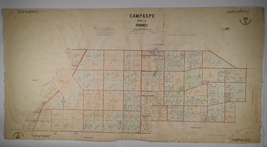 Bendigo Historical Society Inc.
Map - PARISH OF CAMPASPE, November 1880
Map: Parish of Campaspe, County of Rodney. Parish plan G.H.H. Smith Draughtsman August 1880 Examined J.A. Morrison 7.10.80 Photo- Lithographed J. Noone. 1.11.80 Written in green " Cancelled 16.2.66."map, rodney, parish plan, campaspe -
University of Melbourne, Burnley Campus Archives
Plan, City Square, 1977- 1991
(1) Photocopy of plan by City of Melbourne, City Architects Office No VA47. Date not clear (January 1981?). (2) Melbourne Civic Square Stage 1, Level 2: Plan SW Sector/ Lower Square Level. Project and drawing no 7620 WT00, 20.11.1977, Revision date 10.07.1979 by Denton Corker Marshall Pty. Ltd. for Melbourne City Council. (3) Level 2: N.W. Sector. (4) Level 2: S.E. Sector. (5) Level 2: N.E. Sector. (6) Level 3 Plan: N.E. Sector Upper Square Level. (7) Level 3 Plan: S.E. Sector. (8) Melbourne City Square Diagramatic Plan: View from top of Wales Corner Building Refer 2A. (9) Melbourne Cityscope, November 5, 1990, Map 39 pp 1-2 and Map 39 June 1991. (10) Portfolio: City Square by Simon Howe, Site Inventory and Analysis, Concept Plans 1, 2, Preliminary Plan, (all Scale 1:200), Section Elevation A-A, Scale 1:100.city square, melbourne, city of melbourne, denton corker marshall pty. ltd., landscape architecture -
Bendigo Historical Society Inc.
Map - FRED COWIE COLLECTION: AERIAL MAPS OF HEATHCOTE/EPPALOCK, 28-9-60
Map, Heathcote C4, Aerial Survey of Victoria,Photo-map prepared by Department of Crown Lands and Survey from photographs taken in 1960. Copied photographically at the Central Plan Office.Date 28-9-60,C.P.O.Neg.No.21590.Scale 4 inches to 1 mile. Fred Cowie,46 McIvor Rd,Bgo..Central Plan Office.map -
Bendigo Historical Society Inc.
Book - BENDIGO SUB-REGIONAL STRATEGY PLAN 1980
141 page soft cover spiral bound booklet 'Bendigo Sub-Regional Strategy Plan - September 1980' Areas covered , City of Bendigo, Borough of Eaglehawk, Shires of Huntly, Marong and Strathfieldsaye. Maps included.Bendigo Sub-Regional Committee -
University of Melbourne, Burnley Campus Archives
Map, Plan of Early Melbourne Showing Original Crown Allotments, c. 1852
Copy of 'Map of the City of Melbourne, and its Extension, together with Collingwood, Richmond, Hawthorne, the Emerald Hill, and a portion of Prahran Compiled from the Government Plans and Private Survey by William Green.' (2 copies, one enlarged)melbourne, william green, richmond, hawthorne, collingwood -
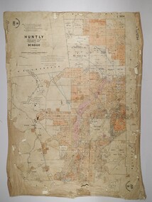 Bendigo Historical Society Inc.
Map - HUNTLY, 16/11/1903
Map: Huntly, County of Bendigo. Parish plan. Drawn by Bartholomew Becket, examined by W S Stephen 15/3/80, examined by J Walshe Sept 1903, additions H Hansford August 1903map, bendigo, parish plan, bartholomew becket, w s stephen, j walshe, h hansford, huntly -
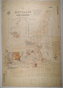 Bendigo Historical Society Inc.
Map - METCALFE, 30/10/1878
Map: Metcalfe, County of Dalhousie. Parish plan (also has a smaller addition glued onto the right hand side) F. J. Vincent Draftsman Oct. 1876 Ex (unreadable signature) Oct 1878map, dalhousie, parish plan, metcalfe, f. j. vincent -
 Ringwood and District Historical Society
Document, Collection of copies of Maps relating to Wieland Houses and Properties (most undated), plus Document entitle Brian Pump's Orchard and House Locations, 25/2/2008
... Collection of copies of Maps relating to Wieland Houses and ...Collection of A4 photocopies of maps and plans, some with yellow highlighting, showing locations of Wieland properties and house including sub-divisions. Mostly in Heathmont but also Scoresby Most pages are undated and do not have original sources Document 28054 entitled Brian Pump's Orchard and House Locations has notes with maps of various houses with numbers corresponding to those on the included maps and also to those in 28054-003 document -
Bendigo Historical Society Inc.
Map - CAMPBELL COLLECTION: BENDIGO AND DISTRICT MAPS, 11-4-29
Map. Huntly, Parishes of Huntly, Nerring and Neilborough. Scale 20 chains to 1 inch. Total area 4738 acres. Prepared in W.P.B. from A and C.L. Plans by W.J. Galbraith 11-4-29. Eaglehawk. IN PENCIL top right of map: Euc areas 1974 Scott & Cole Comp 5,6,7,8,9,12,13. Laurie C.Raynor 10,11,17, Part 16 South of Scotsmans Track, J.T Pierce 14,15,16 North of Scotsman Track. From Neilborough. G.Ward. A.Sloan. K.Walker at bottom of map. (number 368 in map cupboard 1)W.J.Galbraithmap, bendigo, allotments -
Bendigo Historical Society Inc.
Map - FRED COWIE COLLECTION: AERIAL MAPS OF HEATHCOTE/EPPALOCK, 28-9-60
Map, Heathcote C3, Aerial Survey of Victoria, Photo-map prepared by Department of Crown Lands and Survey from photographs taken in 1960.Copied photographically at the Central Plan Office. Date 28-9 60, C.P.O.Neg. No.21588.Campaspe River, Coliban River. Flower Hill. Fred Cowie,46 McIvor Rd.Bendigo (Not located 29.9.2022)Central Plan Office.map