Showing 2283 items
matching parish.
-
 Whitehorse Historical Society Inc.
Document, Certificate of Title, 1928, 1933-1934
Certificate of Title, Nanny Schifferdecker.Certificate of Title, Nanny Schifferdecker. Lots 44, 45,56 & 57 subdivision 3360 Crown portion 97 Parish of Nunawading, County of Bourke 1928. Vol 5406 fol 10881070 1928, Agnew and Craig Streets. Also correspondence re rates enforcement charge 1933.Certificate of Title, Nanny Schifferdecker. land titles, shire of blackburn and mitcham, schifferdecker, hanny, craig street, blackburn south, agnew street, blackburn south -
 Linton and District Historical Society Inc
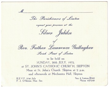
Invitation, Silver Jubilee, Rev. Father Lawrence Gallagher, 1972
White cardboard invitation with blue printed text. The invitation is to celebrate the silver jubilee of Rev. Father Lawrence Gallagher, Parish Priest of Linton, at St. John's Catholic Church, Skipton, Sunday, 30th July, 1972.Text: " The Parishioners of Linton / request your presence at the /Silver Jubilee / of / Rev. Father Lawrence Gallagher / Parish Priest of Linton / to be held on / SUNDAY, 30th JULY, 1972. / at ST. JOHN'S CATHOLIC CHURCH, SKIPTON / Mass at St. John's Church Skipton at 2 p.m. / and afterwards at Mechanics Hall, Skipton. "rev. father lawrence gallagher, st. john's catholic church skipton, silver jubilee -
 City of Moorabbin Historical Society (Operating the Box Cottage Museum)
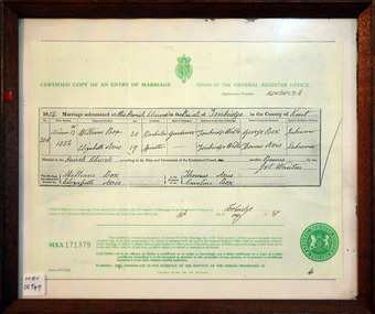
Document - Copy of Marriage Certificate William Box 1854, 14 May 1997
This copy of the Marriage Certificate of William and Elizabeth Avis-Box was obtained by CMHS member Dennis Maynard in May 1997. William Box and Elizabeth Avis Box came to Australia with his parents George and Mary Cripps-Box and siblings in 1856 William Box with his wife Elizabeth Avis Box and 13 children lived and farmed on the block of land in Jasper Road, East Brighton ( now McKinnon / Ormond) that was part of the Henry Dendy Special Survey 1841. Caroline Box, the eldest daughter of George and Mary Cripps-Box, remained in England working as a cook until she joined the family in Australia in 1863. William Box with his wife Elizabeth Avis Box and 13 children lived and farmed on the block of land in Jasper Road, East Brighton ( now McKinnon / Ormond) that was part of the Henry Dendy Special Survey 1841 Box Cottage Museum is the reconstructed pioneer cottage that William and Elizabeth lived in 1865 until they built a new house on the land. The Certified Copy of the Marriage Entry of William Box and Elizabeth Avis at the Parish Church, Tonbridge, Kent, England on November 13th 1854 in a wood frame with glass* CERTIFIED COPY OF AN ENTRY OF MARRIAGE / crest / GIVEN AT THE GENERAL REGISTER OFFICE / Application number C009059/0 / 1854 Marriage solemnised at The Parish Church of Tonbridge in the County of Kent / 206 / November 13th / 1854 / William Box 20 Bachelor Gardener / Elizabeth Avis 19 Spinster/ ………… Signed by William Box , Elizabeth Avis with Thomas Avis and Caroline Box as the Witnesses. Issued at Tonbridge 14th May 1997 MXA 171379 box william, box elizabeth avis, moorabbin, ormond, parish of tonbridge, farmers, dairy, market gardeners, pioneers, early settlers, kent, england, certificates, box caroline, avis thomas, -
Bendigo Historical Society Inc.
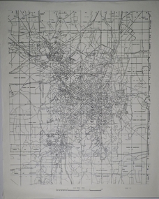
Map - RESURVEY, PARISH OF SANDHURST, 1/08/1891
Map: Resurvey , Parish of Sandhurst sheet 3. Parish plan ( number 203 in Map Cupboard 1)map, bendigo, parish plan, parish of sandhurst resurvey -
Bendigo Historical Society Inc.
Map - PARISHES OF WARRAGAMBA AND MINTO, No date visible
Map: Parishes of Warragamba and Minto,Hand draughted parish plan. (number 290 in map cupboard 1)map, parish plan, warragamba, minto -
Bendigo Historical Society Inc.
Map - KAMAROOKA ALLOTMENTS, 7/06/1894
Map: Parish of Kamarooka Allotments, County of Bendigo. Parish plan (number 288 in map cupboard 1)map, bendigo, allotments, kamarooka, allotments -
Bendigo Historical Society Inc.
Map - BAGSHOT, Circa 1878
Map: Parish of Bagshot, County of Bendigo. Parish plan (coloured) (number 329 in map cupboard 1)map, bendigo, parish plan, bagshot -
Bendigo Historical Society Inc.
Map - GOORNONG, 29/04/1879
Map: Parish of Goornong, County of Bendigo. Parish plan (coloured) (number 326 in map cupboard 1)map, bendigo, parish plan, goornong -
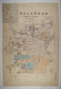 Bendigo Historical Society Inc.
Map - INGLEWOOD, 17/12/1877
Map: Parish of Inglewood, County of Gladstone. Parish plan. Earliest date on map 31/12/75.map, gladstone, parish plan, inglewood -
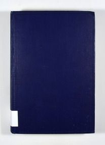 Marysville & District Historical Society
Book, Percy Dearmer, The Parson's Handbook, 1932
The Parson's Handbook contains practical directions both for parsons and others as to the management of the parish church and it's services according to the Anglican use, as set forth in the book of common prayer.Cover is navy blue with the title and author on the spine in gold lettering.non-fictionThe Parson's Handbook contains practical directions both for parsons and others as to the management of the parish church and it's services according to the Anglican use, as set forth in the book of common prayer.parsons, parish church, management, services, anglican, common prayer -
 Bendigo Historical Society Inc.
Map - CAMPBELL COLLECTION: BENDIGO AND DISTRICT MAPS
Map. Parishes and suburbs : North of Bendigo, Parish of Huntly, Parish of Nerring, Parish of Sandhurst, Sydney Flat, Myers Flat, Borough of Eaglehawk, Sailors Gully, Jobs Gully, Harvey Town, California Gully, Maiden Gully, Long Gully, St.Just's Point, Iron Bark.map, bendigo, parishes -
Bendigo Historical Society Inc.
Map - NERRING, 15/06/1937
Map: Parish of Nerring, County of Bendigo. Parish plan Canvas backed ( number 139 in Map Cupboard 1)map, bendigo, rural, nerring, county of bendigo -
Bendigo Historical Society Inc.
Map - PARISH OF SANDHURST SHEET 5A, 1970
Map: Parish of Sandhurst Sheet 5A, County of Bendigo. Parish plan ( number 161 in Map Cupboard 1)map, bendigo, parish plan, parish of sandhurst, county of bendigo -
Bendigo Historical Society Inc.
Map - RAYWOOD, 18/09/1930
Map: Township of Raywood, Parish of Neilborough,County of Bendigo. Parish plan (number 270 in map cupboard 1)map, bendigo, township, raywood -
Bendigo Historical Society Inc.
Map - GOORNONG, 1/10/1906
Map: Town of Goornong, Parish of Goornong, County of Bendigo. Parish plan (number 269 in map cupboard 1)map, bendigo, township, goornong -
Bendigo Historical Society Inc.
Map - PARISH OF MARONG ALLOTMENTS, No date Visible
Map: Parish of Marong Allotments, County of Bendigo. Parish plan Blueprint (number 286 in map cupboard 1)map, bendigo, allotments, marong allotments -
Bendigo Historical Society Inc.
Map - FOSTERVILLE MAP, 19/08/1897
Map: Township of Fosterville, Parish of Ellesmere, County of Bendigo. Parish plan (number 277 in map cupboard 1)map, bendigo, township, fosterville, ellesmere -
Bendigo Historical Society Inc.
Map - YARRABERB, 17/12/1937
Map: Township of Yarraberb, Parish of Yarraberb, County of Bendigo. Parish plan (number 274 in map cupboard 1)map, bendigo, township, yarraberb -
Bendigo Historical Society Inc.
Map - NEWBRIDGE, August 17th 1875
Map: Township of Newbridge, Parish of Tarnagulla, County of Bendigo. Parish plan (number 272 in map cupboard 1)map, bendigo, township, newbridge -
Bendigo Historical Society Inc.
Map - AXEDALE, 12/07/1909
Map: Township of Axedale, Parish of Axedale, County of Bendigo. Parish plan (number 271 in map cupboard 1)map, bendigo, township, axedale -
Bendigo Historical Society Inc.
Map - CALAVIL, 28/08/1874
Map: Country Lands, Parish of Calavil, County of Bendigo. Parish plan (number 334 in map cupboard 1)map, bendigo, country lands, country lands, parish of calavil -
Whitehorse Historical Society Inc.
Document, Crown Grant Register, 10/05/1999
Crown Grant Register - General Law - Parish of Nunawading, 1854 - 1858. Lands Department plan of Parish, 1864.land settlement, victoria. lands department, blood, robert, blood, thomas, burrell, charles, clisby, william, cook, charles, cousens, james, dickensen, william, harding, william, hedding, william, holland, john, jones, william, kefford, richard, lobb, john, morgan, robert rowland, morton, william, o'conner, patrick, orr, joseph, polak, nelson, riley, patrick, smith, l l dr, tranter, william, whitman, francis, williams, william, wilks, joseph, wilson, william, wilton, edward -
 Linton and District Historical Society Inc
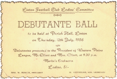
Card - Ticket, Linton Football Club Ladies' Committee Debutante Ball, 1956
Gold-edged yellow ticket with gold lettering, ticket for a debutante ball to be held in the Parish Hall, Linton on Thursday 12th July, 1956. Debutantes to be presented to the President of the Western Plains League, Mr. Elliott, and to Mrs. Elliott. Text: ' Linton Football Club Ladies' Committee / DEBUTANTE BALL / to be held at Parish Hall, Linton / on Thursday, 12th July, 1956 / Debutantes presented to the President of Western Plains / League, Mr. Elliott and Mrs. Elliott, at 9.30 p.m. / Merlin's Orchestra / MRS. W. RINGIN, PRESIDENT M. MOYNIHAN, HON. SECRETARY. ' linton football club ladies' committee, sports, social gatherings, debutante balls, debutantes, mrs. w. ringin, m. moynihan -
 Warrnambool and District Historical Society Inc.
Map, Department of Lands and Survey (Lithographers), Caramut township, 1938
This map of the township of Caramut was produced in 1938 but shows the original land owners of each town allotment and of the surrounding area. The size of all the allotments and the date of the original purchase are also shown. Caramut is a Victorian Western District town on Mustons Creek on the Hamilton Highway 48 kilometres from Warrnambool. This map was used by Rolf Crawley when he was the engineer for the Shire of Warrnambool from 1935 to 1968. The annotations on the map have probably been made by Rolf Crawley as they refer to the records and letter books of his father, John William Crawley, Junior (Shire of Warrnambool Engineer 1895 to 1935). Both Rolf Crawley and his father, John had private businesses as architects, surveyors and engineers and the map could have been used in connection with both their official Shire duties and their private businesses. The last owner of the map was the surveyor, Michael Hand who took over the business of Rolf Crawley in the late 1960s. This map is of great interest firstly because it has all the historical details of the land first purchased in the town of Caramut and area and secondly because it came from the office of Rolf Crawley, the engineer for the Shire of Warrnambool from 1935 to 1968. This is a buff-coloured paper map with a cloth backing. The map details are in black and white print. There are some handwritten red and black annotations on the map. “Town of Caramut Parish of Caramut County of Villiers’town of caramut, john william crawley junior, warrnambool, rolf crawley, warrnambool -
Port Melbourne Historical & Preservation Society
Map - Footscray, Public Lands Office, 19 Oct 1857
Map of Footscray, west of Saltwater Creek; south of Hopkins Street, east of Railway and north southern boundary of Botanical Garden reserve.The Township of Footscray, Parish of Cut-Paw-Pawfootscray -
Stawell Historical Society Inc
Map - Subdivision map, Subdivision of North Woodlands Estate Map
Shows Homestead Cottage and Dam, Plus Shed. Malakoff NavarreA3 photocopy of MapParishes of Malakoff and Navarre. County of Kara karasurvey -
 Running Rabbits Military Museum operated by the Upwey Belgrave RSL Sub Branch
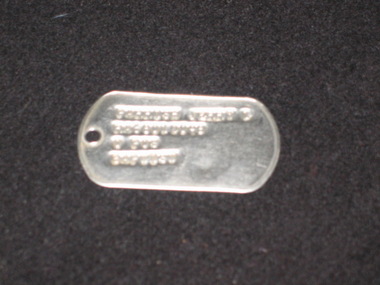
ID Tags
Jerry L Parish RA68012058equipment, 1964, ran -
Stawell Historical Society Inc
Map - Parish Map, Barkley County of Kara Kara 1920's, 1920's ?
Johnsons Gully LeadPaper map of Parish of BarkelyBy Authority H.J. Green Govt Printer. Photo Lithographed at the Department of Lands and Survey. Melbourne 22.11.2survey -
Whitehorse Historical Society Inc.
Map, Melbourne Geological Map, 1937
Geological Map of Melbourne & Suburbs.Geological Map of Melbourne & Suburbs. Scale: 40 chains to 1 inch with inset 10 miles to 1 inch. Includes Municipal and Parish boundaries, railways and stations, electric tramways, cable tramways, Post Offices and State schools. Area bounded by Braybrook, Preston, Blackburn & Brighton. Printed on linen.Geological Map of Melbourne & Suburbs. melbourne, maps -
 Surrey Hills Historical Society Collection
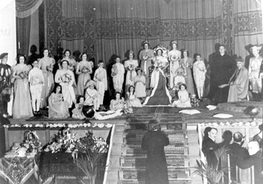
Photograph, Holy Redeemer Queen Carnival, 1938, 1938
Donor identifies the following: Parish priest - Dr W M Collins Queen - Molly Baker Attendants - Marg Wise, Lola Sans, Gertie Baker Flower girls - Madge Wise, Molly Brown, Rita O'Sullivan Probably taken in Our Holy Redeemer Hall, Mont Albert Road, Surrey Hills.This is one of only a few photos in our collection which are evidence of Queen Carnivals which originated as fundraising events. They were particularly popular in both Australian and New Zealand during the early 20th century. They were particularly common during and after World War I when they were used to raise funds for returned soldiers. It is currently the only photo in the collection of a social event connected to Our Holy Redeemer Church and the only one which includes Dr William M Collins who was the parish priest from 1933-1941. Dr Collins was a significant figure in the Catholic Church in Melbourne in the first half of the 20th century. REF: The Advocate: The first priest-editor by Fiona Power; Kairos Catholic Journal Volume 22, Issue 16. - 2 September 2011": Summary: Born in Kilmore in 1884, William Collins attended South Melbourne College and then the University of Melbourne, where he assisted in the formation of the Newman Society of Victoria. After graduating in arts in 1911, he worked at the Melbourne Public Library and the Education Department. In 1912, at the age of 28, he went to Rome, where he studied for the priesthood at Urban College. He obtained doctorates in philosophy and theology and was ordained on 3 June 1917. He returned to Melbourne and was appointed curate at St Mary’s, West Melbourne, and St Francis’, Lonsdale Street. In 1918, Dr Collins became editor of The Advocate. He remained in the role for seven years. Dr Collins was parish priest of Dandenong, Daylesford, East Malvern, Surrey Hills and Kew, and administrator at St Francis’. He died in 1959 and a Requiem Mass was held at Sacred Heart, Kew. Black and white photo of the participants in the Queen Carnival arranged on a stage in a tableaux of the coronation of the Queen. To the right are the parish priest and the archbishop and there is a man at the bottom of the stairs centre front of the stage. Guests are seated at a table to the right of the stairs and to the left of the stairs is a table with floral arrangements and other objects. "1938" hand-written on the original photo in upper LH corner.festivals and celebrations, queen carnivals, our holy redeemer church, dr w m collins, rev william m collins, (miss) molly baker, (miss) marg wise, (miss) lola sans, (miss) gertie baker, (miss) madge wise, (miss) molly brown, (miss) rita o'sullivan