Showing 937 items matching " reservoir"
-
 Eltham District Historical Society Inc
Photograph, Liz Pidgeon, Heritage Excursion; Maroondah Aqueduct, 3 September 2016, 3 September 2016
Newsletter No., 229, August 2016 Heritage Excursion - Maroondah Aqueduct Walk - Saturday 3rd September The Maroondah Aqueduct was once a major link in Melbourne’s water supply system. It was built between 1886 and 1891 to transfer water from the Watts River near Healesville to the Preston Reservoir. It was 66 km in length, made up of 41 km of open channel, 10 km of tunnel through hills and 15 km of pipeline across stream valleys known as inverted siphons. The section of the aqueduct through the Eltham area has been abandoned since the 1980s but the open channel has largely been retained. A recreational path follows the aqueduct reserve. For our excursion on 3rd September we intend to walk along the section of the aqueduct adjacent to Allendale Road. This is a section not visited on previous excursions and includes the transition from open channel to the inverted siphon across the Diamond Creek valley. Apart from the aqueduct itself the main feature of the walk is the extensive views across Eltham North and Diamond Creek. Along the way we will talk about the history of the aqueduct and the area. This easy walk is about 3 km return and will take 2 to 2.5 hours. It will start at 2pm at the junction of Allendale Road with Godber Road and Zig Zag Road North, officially Diamond Creek, but on the northern boundary of Eltham. (Melway ref.12 B10). Born Digitalmaroondah aqueduct, eltham north, activities, eltham district historical society, heritage excursion, aqueduct trail, cattle yard -
 Eltham District Historical Society Inc
Photograph, Liz Pidgeon, Heritage Excursion; Maroondah Aqueduct, 3 September 2016, 3 September 2016
Newsletter No., 229, August 2016 Heritage Excursion - Maroondah Aqueduct Walk - Saturday 3rd September The Maroondah Aqueduct was once a major link in Melbourne’s water supply system. It was built between 1886 and 1891 to transfer water from the Watts River near Healesville to the Preston Reservoir. It was 66 km in length, made up of 41 km of open channel, 10 km of tunnel through hills and 15 km of pipeline across stream valleys known as inverted siphons. The section of the aqueduct through the Eltham area has been abandoned since the 1980s but the open channel has largely been retained. A recreational path follows the aqueduct reserve. For our excursion on 3rd September we intend to walk along the section of the aqueduct adjacent to Allendale Road. This is a section not visited on previous excursions and includes the transition from open channel to the inverted siphon across the Diamond Creek valley. Apart from the aqueduct itself the main feature of the walk is the extensive views across Eltham North and Diamond Creek. Along the way we will talk about the history of the aqueduct and the area. This easy walk is about 3 km return and will take 2 to 2.5 hours. It will start at 2pm at the junction of Allendale Road with Godber Road and Zig Zag Road North, officially Diamond Creek, but on the northern boundary of Eltham. (Melway ref.12 B10). Born Digitalmaroondah aqueduct, eltham north, activities, eltham district historical society, heritage excursion, aqueduct trail, water-pipe, pipe -
 Eltham District Historical Society Inc
Photograph, Liz Pidgeon, Heritage Excursion; Maroondah Aqueduct, 3 September 2016, 3 September 2016
Newsletter No., 229, August 2016 Heritage Excursion - Maroondah Aqueduct Walk - Saturday 3rd September The Maroondah Aqueduct was once a major link in Melbourne’s water supply system. It was built between 1886 and 1891 to transfer water from the Watts River near Healesville to the Preston Reservoir. It was 66 km in length, made up of 41 km of open channel, 10 km of tunnel through hills and 15 km of pipeline across stream valleys known as inverted siphons. The section of the aqueduct through the Eltham area has been abandoned since the 1980s but the open channel has largely been retained. A recreational path follows the aqueduct reserve. For our excursion on 3rd September we intend to walk along the section of the aqueduct adjacent to Allendale Road. This is a section not visited on previous excursions and includes the transition from open channel to the inverted siphon across the Diamond Creek valley. Apart from the aqueduct itself the main feature of the walk is the extensive views across Eltham North and Diamond Creek. Along the way we will talk about the history of the aqueduct and the area. This easy walk is about 3 km return and will take 2 to 2.5 hours. It will start at 2pm at the junction of Allendale Road with Godber Road and Zig Zag Road North, officially Diamond Creek, but on the northern boundary of Eltham. (Melway ref.12 B10). Born Digitalmaroondah aqueduct, eltham north, activities, eltham district historical society, heritage excursion, aqueduct trail, cattle yards -
 Eltham District Historical Society Inc
Photograph, Liz Pidgeon, Heritage Excursion; Maroondah Aqueduct, 3 September 2016, 3 September 2016
Heritage Excursion - Maroondah Aqueduct Walk - Saturday 3rd September The Maroondah Aqueduct was once a major link in Melbourne’s water supply system. It was built between 1886 and 1891 to transfer water from the Watts River near Healesville to the Preston Reservoir. It was 66 km in length, made up of 41 km of open channel, 10 km of tunnel through hills and 15 km of pipeline across stream valleys known as inverted siphons. The section of the aqueduct through the Eltham area has been abandoned since the 1980s but the open channel has largely been retained. A recreational path follows the aqueduct reserve. For our excursion on 3rd September we intend to walk along the section of the aqueduct adjacent to Allendale Road. This is a section not visited on previous excursions and includes the transition from open channel to the inverted siphon across the Diamond Creek valley. Apart from the aqueduct itself the main feature of the walk is the extensive views across Eltham North and Diamond Creek. Along the way we will talk about the history of the aqueduct and the area. This easy walk is about 3 km return and will take 2 to 2.5 hours. It will start at 2pm at the junction of Allendale Road with Godber Road and Zig Zag Road North, officially Diamond Creek, but on the northern boundary of Eltham. (Melway ref.12 B10). From Newsletter No., 229, August 2016 Born Digitalmaroondah aqueduct, eltham north, activities, eltham district historical society, heritage excursion, aqueduct trail, water-pipe, pipe -
 Eltham District Historical Society Inc
Photograph, Liz Pidgeon, Heritage Excursion; Maroondah Aqueduct, 3 September 2016, 3 September 2016
Newsletter No., 229, August 2016 Heritage Excursion - Maroondah Aqueduct Walk - Saturday 3rd September The Maroondah Aqueduct was once a major link in Melbourne’s water supply system. It was built between 1886 and 1891 to transfer water from the Watts River near Healesville to the Preston Reservoir. It was 66 km in length, made up of 41 km of open channel, 10 km of tunnel through hills and 15 km of pipeline across stream valleys known as inverted siphons. The section of the aqueduct through the Eltham area has been abandoned since the 1980s but the open channel has largely been retained. A recreational path follows the aqueduct reserve. For our excursion on 3rd September we intend to walk along the section of the aqueduct adjacent to Allendale Road. This is a section not visited on previous excursions and includes the transition from open channel to the inverted siphon across the Diamond Creek valley. Apart from the aqueduct itself the main feature of the walk is the extensive views across Eltham North and Diamond Creek. Along the way we will talk about the history of the aqueduct and the area. This easy walk is about 3 km return and will take 2 to 2.5 hours. It will start at 2pm at the junction of Allendale Road with Godber Road and Zig Zag Road North, officially Diamond Creek, but on the northern boundary of Eltham. (Melway ref.12 B10). Born Digitalmaroondah aqueduct, eltham north, activities, eltham district historical society, heritage excursion, aqueduct trail, open channel -
 Eltham District Historical Society Inc
Photograph, Liz Pidgeon, Heritage Excursion; Maroondah Aqueduct, 3 September 2016, 3 September 2016
Newsletter No., 229, August 2016 Heritage Excursion - Maroondah Aqueduct Walk - Saturday 3rd September The Maroondah Aqueduct was once a major link in Melbourne’s water supply system. It was built between 1886 and 1891 to transfer water from the Watts River near Healesville to the Preston Reservoir. It was 66 km in length, made up of 41 km of open channel, 10 km of tunnel through hills and 15 km of pipeline across stream valleys known as inverted siphons. The section of the aqueduct through the Eltham area has been abandoned since the 1980s but the open channel has largely been retained. A recreational path follows the aqueduct reserve. For our excursion on 3rd September we intend to walk along the section of the aqueduct adjacent to Allendale Road. This is a section not visited on previous excursions and includes the transition from open channel to the inverted siphon across the Diamond Creek valley. Apart from the aqueduct itself the main feature of the walk is the extensive views across Eltham North and Diamond Creek. Along the way we will talk about the history of the aqueduct and the area. This easy walk is about 3 km return and will take 2 to 2.5 hours. It will start at 2pm at the junction of Allendale Road with Godber Road and Zig Zag Road North, officially Diamond Creek, but on the northern boundary of Eltham. (Melway ref.12 B10). Born Digitalmaroondah aqueduct, eltham north, activities, eltham district historical society, heritage excursion, open channel, rubbish, aqueduct trail -
 Eltham District Historical Society Inc
Photograph, Liz Pidgeon, Heritage Excursion; Maroondah Aqueduct, 3 September 2016, 3 September 2016
Newsletter No., 229, August 2016 Heritage Excursion - Maroondah Aqueduct Walk - Saturday 3rd September The Maroondah Aqueduct was once a major link in Melbourne’s water supply system. It was built between 1886 and 1891 to transfer water from the Watts River near Healesville to the Preston Reservoir. It was 66 km in length, made up of 41 km of open channel, 10 km of tunnel through hills and 15 km of pipeline across stream valleys known as inverted siphons. The section of the aqueduct through the Eltham area has been abandoned since the 1980s but the open channel has largely been retained. A recreational path follows the aqueduct reserve. For our excursion on 3rd September we intend to walk along the section of the aqueduct adjacent to Allendale Road. This is a section not visited on previous excursions and includes the transition from open channel to the inverted siphon across the Diamond Creek valley. Apart from the aqueduct itself the main feature of the walk is the extensive views across Eltham North and Diamond Creek. Along the way we will talk about the history of the aqueduct and the area. This easy walk is about 3 km return and will take 2 to 2.5 hours. It will start at 2pm at the junction of Allendale Road with Godber Road and Zig Zag Road North, officially Diamond Creek, but on the northern boundary of Eltham. (Melway ref.12 B10). Born Digitalmaroondah aqueduct, eltham north, activities, eltham district historical society, heritage excursion, aqueduct trail, open channel -
 Eltham District Historical Society Inc
Photograph, Liz Pidgeon, Heritage Excursion; Maroondah Aqueduct, 3 September 2016, 3 September 2016
Newsletter No., 229, August 2016 Heritage Excursion - Maroondah Aqueduct Walk - Saturday 3rd September The Maroondah Aqueduct was once a major link in Melbourne’s water supply system. It was built between 1886 and 1891 to transfer water from the Watts River near Healesville to the Preston Reservoir. It was 66 km in length, made up of 41 km of open channel, 10 km of tunnel through hills and 15 km of pipeline across stream valleys known as inverted siphons. The section of the aqueduct through the Eltham area has been abandoned since the 1980s but the open channel has largely been retained. A recreational path follows the aqueduct reserve. For our excursion on 3rd September we intend to walk along the section of the aqueduct adjacent to Allendale Road. This is a section not visited on previous excursions and includes the transition from open channel to the inverted siphon across the Diamond Creek valley. Apart from the aqueduct itself the main feature of the walk is the extensive views across Eltham North and Diamond Creek. Along the way we will talk about the history of the aqueduct and the area. This easy walk is about 3 km return and will take 2 to 2.5 hours. It will start at 2pm at the junction of Allendale Road with Godber Road and Zig Zag Road North, officially Diamond Creek, but on the northern boundary of Eltham. (Melway ref.12 B10). Born Digitalmaroondah aqueduct, eltham north, activities, eltham district historical society, heritage excursion, aqueduct trail, spring -
 Eltham District Historical Society Inc
Photograph, Liz Pidgeon, Heritage Excursion; Maroondah Aqueduct, 3 September 2016, 3 September 2016
Photo of Melbourne City skyline. Newsletter No., 229, August 2016 Heritage Excursion - Maroondah Aqueduct Walk - Saturday 3rd September The Maroondah Aqueduct was once a major link in Melbourne’s water supply system. It was built between 1886 and 1891 to transfer water from the Watts River near Healesville to the Preston Reservoir. It was 66 km in length, made up of 41 km of open channel, 10 km of tunnel through hills and 15 km of pipeline across stream valleys known as inverted siphons. The section of the aqueduct through the Eltham area has been abandoned since the 1980s but the open channel has largely been retained. A recreational path follows the aqueduct reserve. For our excursion on 3rd September we intend to walk along the section of the aqueduct adjacent to Allendale Road. This is a section not visited on previous excursions and includes the transition from open channel to the inverted siphon across the Diamond Creek valley. Apart from the aqueduct itself the main feature of the walk is the extensive views across Eltham North and Diamond Creek. Along the way we will talk about the history of the aqueduct and the area. This easy walk is about 3 km return and will take 2 to 2.5 hours. It will start at 2pm at the junction of Allendale Road with Godber Road and Zig Zag Road North, officially Diamond Creek, but on the northern boundary of Eltham. (Melway ref.12 B10). Born Digitalmaroondah aqueduct, eltham north, activities, eltham district historical society, heritage excursion, skyline, melbourne, aqueduct trail -
 Eltham District Historical Society Inc
Photograph, Liz Pidgeon, Heritage Excursion; Maroondah Aqueduct, 3 September 2016, 3 September 2016
Newsletter No., 229, August 2016 Heritage Excursion - Maroondah Aqueduct Walk - Saturday 3rd September The Maroondah Aqueduct was once a major link in Melbourne’s water supply system. It was built between 1886 and 1891 to transfer water from the Watts River near Healesville to the Preston Reservoir. It was 66 km in length, made up of 41 km of open channel, 10 km of tunnel through hills and 15 km of pipeline across stream valleys known as inverted siphons. The section of the aqueduct through the Eltham area has been abandoned since the 1980s but the open channel has largely been retained. A recreational path follows the aqueduct reserve. For our excursion on 3rd September we intend to walk along the section of the aqueduct adjacent to Allendale Road. This is a section not visited on previous excursions and includes the transition from open channel to the inverted siphon across the Diamond Creek valley. Apart from the aqueduct itself the main feature of the walk is the extensive views across Eltham North and Diamond Creek. Along the way we will talk about the history of the aqueduct and the area. This easy walk is about 3 km return and will take 2 to 2.5 hours. It will start at 2pm at the junction of Allendale Road with Godber Road and Zig Zag Road North, officially Diamond Creek, but on the northern boundary of Eltham. (Melway ref.12 B10). Born Digitalmaroondah aqueduct, eltham north, activities, eltham district historical society, heritage excursion, acqueduct trail, spring -
 Eltham District Historical Society Inc
Photograph, Liz Pidgeon, Heritage Excursion; Maroondah Aqueduct, 3 September 2016, 3 September 2016
Newsletter No., 229, August 2016 Heritage Excursion - Maroondah Aqueduct Walk - Saturday 3rd September The Maroondah Aqueduct was once a major link in Melbourne’s water supply system. It was built between 1886 and 1891 to transfer water from the Watts River near Healesville to the Preston Reservoir. It was 66 km in length, made up of 41 km of open channel, 10 km of tunnel through hills and 15 km of pipeline across stream valleys known as inverted siphons. The section of the aqueduct through the Eltham area has been abandoned since the 1980s but the open channel has largely been retained. A recreational path follows the aqueduct reserve. For our excursion on 3rd September we intend to walk along the section of the aqueduct adjacent to Allendale Road. This is a section not visited on previous excursions and includes the transition from open channel to the inverted siphon across the Diamond Creek valley. Apart from the aqueduct itself the main feature of the walk is the extensive views across Eltham North and Diamond Creek. Along the way we will talk about the history of the aqueduct and the area. This easy walk is about 3 km return and will take 2 to 2.5 hours. It will start at 2pm at the junction of Allendale Road with Godber Road and Zig Zag Road North, officially Diamond Creek, but on the northern boundary of Eltham. (Melway ref.12 B10). Born Digitalmaroondah aqueduct, eltham north, activities, eltham district historical society, heritage excursion, aqueduct trail, open channel -
 Eltham District Historical Society Inc
Photograph, Liz Pidgeon, Heritage Excursion; Maroondah Aqueduct, 3 September 2016, 3 September 2016
Newsletter No., 229, August 2016 Heritage Excursion - Maroondah Aqueduct Walk - Saturday 3rd September The Maroondah Aqueduct was once a major link in Melbourne’s water supply system. It was built between 1886 and 1891 to transfer water from the Watts River near Healesville to the Preston Reservoir. It was 66 km in length, made up of 41 km of open channel, 10 km of tunnel through hills and 15 km of pipeline across stream valleys known as inverted siphons. The section of the aqueduct through the Eltham area has been abandoned since the 1980s but the open channel has largely been retained. A recreational path follows the aqueduct reserve. For our excursion on 3rd September we intend to walk along the section of the aqueduct adjacent to Allendale Road. This is a section not visited on previous excursions and includes the transition from open channel to the inverted siphon across the Diamond Creek valley. Apart from the aqueduct itself the main feature of the walk is the extensive views across Eltham North and Diamond Creek. Along the way we will talk about the history of the aqueduct and the area. This easy walk is about 3 km return and will take 2 to 2.5 hours. It will start at 2pm at the junction of Allendale Road with Godber Road and Zig Zag Road North, officially Diamond Creek, but on the northern boundary of Eltham. (Melway ref.12 B10). Born Digitalmaroondah aqueduct, eltham north, activities, eltham district historical society, heritage excursion, aqueduct trail -
 Eltham District Historical Society Inc
Photograph, Liz Pidgeon, Heritage Excursion; Maroondah Aqueduct, 3 September 2016, 3 September 2016
Newsletter No., 229, August 2016 Heritage Excursion - Maroondah Aqueduct Walk - Saturday 3rd September The Maroondah Aqueduct was once a major link in Melbourne’s water supply system. It was built between 1886 and 1891 to transfer water from the Watts River near Healesville to the Preston Reservoir. It was 66 km in length, made up of 41 km of open channel, 10 km of tunnel through hills and 15 km of pipeline across stream valleys known as inverted siphons. The section of the aqueduct through the Eltham area has been abandoned since the 1980s but the open channel has largely been retained. A recreational path follows the aqueduct reserve. For our excursion on 3rd September we intend to walk along the section of the aqueduct adjacent to Allendale Road. This is a section not visited on previous excursions and includes the transition from open channel to the inverted siphon across the Diamond Creek valley. Apart from the aqueduct itself the main feature of the walk is the extensive views across Eltham North and Diamond Creek. Along the way we will talk about the history of the aqueduct and the area. This easy walk is about 3 km return and will take 2 to 2.5 hours. It will start at 2pm at the junction of Allendale Road with Godber Road and Zig Zag Road North, officially Diamond Creek, but on the northern boundary of Eltham. (Melway ref.12 B10). Born Digitalmaroondah aqueduct, eltham north, activities, eltham district historical society, heritage excursion, aqueduct trail, open channel, pipe -
 Eltham District Historical Society Inc
Photograph, Liz Pidgeon, Heritage Excursion; Maroondah Aqueduct, 3 September 2016, 3 September 2016
Newsletter No., 229, August 2016 Heritage Excursion - Maroondah Aqueduct Walk - Saturday 3rd September The Maroondah Aqueduct was once a major link in Melbourne’s water supply system. It was built between 1886 and 1891 to transfer water from the Watts River near Healesville to the Preston Reservoir. It was 66 km in length, made up of 41 km of open channel, 10 km of tunnel through hills and 15 km of pipeline across stream valleys known as inverted siphons. The section of the aqueduct through the Eltham area has been abandoned since the 1980s but the open channel has largely been retained. A recreational path follows the aqueduct reserve. For our excursion on 3rd September we intend to walk along the section of the aqueduct adjacent to Allendale Road. This is a section not visited on previous excursions and includes the transition from open channel to the inverted siphon across the Diamond Creek valley. Apart from the aqueduct itself the main feature of the walk is the extensive views across Eltham North and Diamond Creek. Along the way we will talk about the history of the aqueduct and the area. This easy walk is about 3 km return and will take 2 to 2.5 hours. It will start at 2pm at the junction of Allendale Road with Godber Road and Zig Zag Road North, officially Diamond Creek, but on the northern boundary of Eltham. (Melway ref.12 B10). Born Digitalmaroondah aqueduct, eltham north, activities, eltham district historical society, heritage excursion, aqueduct trail -
 Eltham District Historical Society Inc
Photograph, Liz Pidgeon, Heritage Excursion; Maroondah Aqueduct, 3 September 2016, 3 September 2016
Newsletter No., 229, August 2016 Heritage Excursion - Maroondah Aqueduct Walk - Saturday 3rd September The Maroondah Aqueduct was once a major link in Melbourne’s water supply system. It was built between 1886 and 1891 to transfer water from the Watts River near Healesville to the Preston Reservoir. It was 66 km in length, made up of 41 km of open channel, 10 km of tunnel through hills and 15 km of pipeline across stream valleys known as inverted siphons. The section of the aqueduct through the Eltham area has been abandoned since the 1980s but the open channel has largely been retained. A recreational path follows the aqueduct reserve. For our excursion on 3rd September we intend to walk along the section of the aqueduct adjacent to Allendale Road. This is a section not visited on previous excursions and includes the transition from open channel to the inverted siphon across the Diamond Creek valley. Apart from the aqueduct itself the main feature of the walk is the extensive views across Eltham North and Diamond Creek. Along the way we will talk about the history of the aqueduct and the area. This easy walk is about 3 km return and will take 2 to 2.5 hours. It will start at 2pm at the junction of Allendale Road with Godber Road and Zig Zag Road North, officially Diamond Creek, but on the northern boundary of Eltham. (Melway ref.12 B10). Born Digitalmaroondah aqueduct, eltham north, activities, eltham district historical society, heritage excursion, aqueduct trail, russell yeoman -
 Eltham District Historical Society Inc
Photograph, Liz Pidgeon, Heritage Excursion; Maroondah Aqueduct, 3 September 2016, 3 September 2016
Newsletter No., 229, August 2016 Heritage Excursion - Maroondah Aqueduct Walk - Saturday 3rd September The Maroondah Aqueduct was once a major link in Melbourne’s water supply system. It was built between 1886 and 1891 to transfer water from the Watts River near Healesville to the Preston Reservoir. It was 66 km in length, made up of 41 km of open channel, 10 km of tunnel through hills and 15 km of pipeline across stream valleys known as inverted siphons. The section of the aqueduct through the Eltham area has been abandoned since the 1980s but the open channel has largely been retained. A recreational path follows the aqueduct reserve. For our excursion on 3rd September we intend to walk along the section of the aqueduct adjacent to Allendale Road. This is a section not visited on previous excursions and includes the transition from open channel to the inverted siphon across the Diamond Creek valley. Apart from the aqueduct itself the main feature of the walk is the extensive views across Eltham North and Diamond Creek. Along the way we will talk about the history of the aqueduct and the area. This easy walk is about 3 km return and will take 2 to 2.5 hours. It will start at 2pm at the junction of Allendale Road with Godber Road and Zig Zag Road North, officially Diamond Creek, but on the northern boundary of Eltham. (Melway ref.12 B10). Born Digitalmaroondah aqueduct, eltham north, activities, eltham district historical society, heritage excursion, aqueduct trail -
 Eltham District Historical Society Inc
Photograph, Liz Pidgeon, Heritage Excursion; Maroondah Aqueduct, 3 September 2016, 3 September 2016
Newsletter No., 229, August 2016 Heritage Excursion - Maroondah Aqueduct Walk - Saturday 3rd September The Maroondah Aqueduct was once a major link in Melbourne’s water supply system. It was built between 1886 and 1891 to transfer water from the Watts River near Healesville to the Preston Reservoir. It was 66 km in length, made up of 41 km of open channel, 10 km of tunnel through hills and 15 km of pipeline across stream valleys known as inverted siphons. The section of the aqueduct through the Eltham area has been abandoned since the 1980s but the open channel has largely been retained. A recreational path follows the aqueduct reserve. For our excursion on 3rd September we intend to walk along the section of the aqueduct adjacent to Allendale Road. This is a section not visited on previous excursions and includes the transition from open channel to the inverted siphon across the Diamond Creek valley. Apart from the aqueduct itself the main feature of the walk is the extensive views across Eltham North and Diamond Creek. Along the way we will talk about the history of the aqueduct and the area. This easy walk is about 3 km return and will take 2 to 2.5 hours. It will start at 2pm at the junction of Allendale Road with Godber Road and Zig Zag Road North, officially Diamond Creek, but on the northern boundary of Eltham. (Melway ref.12 B10). Born Digitalmaroondah aqueduct, eltham north, activities, eltham district historical society, heritage excursion, aqueduct trail, open channel -
 Eltham District Historical Society Inc
Photograph, Liz Pidgeon, Heritage Excursion; Maroondah Aqueduct, 3 September 2016, 3 September 2016
Newsletter No., 229, August 2016 Heritage Excursion - Maroondah Aqueduct Walk - Saturday 3rd September The Maroondah Aqueduct was once a major link in Melbourne’s water supply system. It was built between 1886 and 1891 to transfer water from the Watts River near Healesville to the Preston Reservoir. It was 66 km in length, made up of 41 km of open channel, 10 km of tunnel through hills and 15 km of pipeline across stream valleys known as inverted siphons. The section of the aqueduct through the Eltham area has been abandoned since the 1980s but the open channel has largely been retained. A recreational path follows the aqueduct reserve. For our excursion on 3rd September we intend to walk along the section of the aqueduct adjacent to Allendale Road. This is a section not visited on previous excursions and includes the transition from open channel to the inverted siphon across the Diamond Creek valley. Apart from the aqueduct itself the main feature of the walk is the extensive views across Eltham North and Diamond Creek. Along the way we will talk about the history of the aqueduct and the area. This easy walk is about 3 km return and will take 2 to 2.5 hours. It will start at 2pm at the junction of Allendale Road with Godber Road and Zig Zag Road North, officially Diamond Creek, but on the northern boundary of Eltham. (Melway ref.12 B10). Born Digitalmaroondah aqueduct, eltham north, activities, eltham district historical society, heritage excursion -
 Eltham District Historical Society Inc
Photograph, Liz Pidgeon, Heritage Excursion; Maroondah Aqueduct, 3 September 2016, 3 September 2016
Newsletter No., 229, August 2016 Heritage Excursion - Maroondah Aqueduct Walk - Saturday 3rd September The Maroondah Aqueduct was once a major link in Melbourne’s water supply system. It was built between 1886 and 1891 to transfer water from the Watts River near Healesville to the Preston Reservoir. It was 66 km in length, made up of 41 km of open channel, 10 km of tunnel through hills and 15 km of pipeline across stream valleys known as inverted siphons. The section of the aqueduct through the Eltham area has been abandoned since the 1980s but the open channel has largely been retained. A recreational path follows the aqueduct reserve. For our excursion on 3rd September we intend to walk along the section of the aqueduct adjacent to Allendale Road. This is a section not visited on previous excursions and includes the transition from open channel to the inverted siphon across the Diamond Creek valley. Apart from the aqueduct itself the main feature of the walk is the extensive views across Eltham North and Diamond Creek. Along the way we will talk about the history of the aqueduct and the area. This easy walk is about 3 km return and will take 2 to 2.5 hours. It will start at 2pm at the junction of Allendale Road with Godber Road and Zig Zag Road North, officially Diamond Creek, but on the northern boundary of Eltham. (Melway ref.12 B10). Born Digitalmaroondah aqueduct, eltham north, activities, eltham district historical society, heritage excursion, aqueduct trail -
 Eltham District Historical Society Inc
Photograph, Liz Pidgeon, Heritage Excursion; Maroondah Aqueduct, 3 September 2016, 3 September 2016
Newsletter No., 229, August 2016 Heritage Excursion - Maroondah Aqueduct Walk - Saturday 3rd September The Maroondah Aqueduct was once a major link in Melbourne’s water supply system. It was built between 1886 and 1891 to transfer water from the Watts River near Healesville to the Preston Reservoir. It was 66 km in length, made up of 41 km of open channel, 10 km of tunnel through hills and 15 km of pipeline across stream valleys known as inverted siphons. The section of the aqueduct through the Eltham area has been abandoned since the 1980s but the open channel has largely been retained. A recreational path follows the aqueduct reserve. For our excursion on 3rd September we intend to walk along the section of the aqueduct adjacent to Allendale Road. This is a section not visited on previous excursions and includes the transition from open channel to the inverted siphon across the Diamond Creek valley. Apart from the aqueduct itself the main feature of the walk is the extensive views across Eltham North and Diamond Creek. Along the way we will talk about the history of the aqueduct and the area. This easy walk is about 3 km return and will take 2 to 2.5 hours. It will start at 2pm at the junction of Allendale Road with Godber Road and Zig Zag Road North, officially Diamond Creek, but on the northern boundary of Eltham. (Melway ref.12 B10). Born Digitalmaroondah aqueduct, eltham north, activities, eltham district historical society, heritage excursion, aqueduct trail -
 Flagstaff Hill Maritime Museum and Village
Container - Ink Bottle, 19th to early-20th century
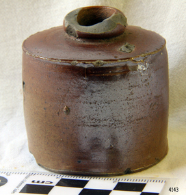
This design of ink bottle or ink well was commonly referred to as a ‘penny ink well’ because it was very inexpensive to produce. It is also known as a dwarf bottle. Pen and ink has been in use for hand writing from about the seventh century up until the mid-20th century. Up until around the mid-19th century a quill pen made from a bird’s feather was used. In the 1850s the steel point pen was invented and could be manufactured on machines in large quantities. In the 1880s a successful portable fountain pen was designed, giving a smooth flowing ink and ease of use. Ink wells, used with steel nib dip pens, were commonly used up until the mid-20th century. The pens only held a small amount of ink so users had to frequently dip the nib of the pen into an ink well for more ink. Hand writing with pen and ink left wet writing on the paper, so blotting paper was carefully used to absorb the excess ink and prevent smudging. Ink could be purchased, ready to use, or in the powdered form, which needed to be mixed with water. After the invention of fountain pens, which had a reservoir of ink, and then ballpoint pens, which also had ink that flowed freely, the dip pen was slowly replaced. However, artisans continue to use nib pens to create beautiful calligraphy.This ink well is historically significant as it represents methods of hand written communication that were still common up until the mid-20th century, when fountain pens and ballpoint pens took over in popularity and convenience.Ink bottle or ink well, sometimes called a Penny Ink Well. Cylindrical body, salt-glazed, brown ceramic stoneware bottle, handmade. Stoneware bottle. flagstaff hill, warrnambool, shipwreck coast, flagstaff hill maritime museum, flagstaff hill maritime village, maritime museum, great ocean road, shipwreck artefact, writing equipment, writing accessory, office equipment, stationery, domestic, stoneware, clay, ceramic, pottery, ink well, inkwell, ink bottle, penny ink well, nib pen, dip pen, ink, hand writing, record keeping, household, business, vintage, blotting paper, dwarf bottle -
 Kiewa Valley Historical Society
Meter Ammeter Recorder, Circa 1950
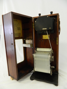
This testing voltmeter recorder was last certified by SEC Vic laboratories on the 17/4/77. It was used extensively as mobile recorder placed for periods of one month at locations experiencing unacceptable fluctuations of power. These locations would cover the North East regions of Victoria. They cover voltage drops at domestic and business properties especially those that were experiencing regular fluctuations(daily) at approximately the same time of the day. As the electrical network is required to operate within a set level of voltage, fluctuations outside of this has to be investigated and necessary remedial action taken. This is especially so for rural properties where power "drainage" can occur through animal/bird and tree interference. It can also be the result of defective wiring and overloading at peek operational times (milking machines).This mobile voltage recorder is very significant to the Kiewa Valley because it highlights the difficulties that can occur in maintaining a power supply that experiences fluctuating power demands by the rural industries that it supplies. The requirement of a mobile testing apparatus to cover the various sections in the Kiewa Valley and other rural areas in the northeast region is one of necessity as electricity once connected to a rural property is a labour saving supply as generators on rural properties require a higher degree of maintenance an ultimately at a higher cost. The testing of the SEC Vic supplied electricity to rural properties,those who had previously run on generators, had to be quick and unassuming with certainty of correct supply levels.The mechanism of this voltage recorder has been installed(by the manufacturer) into its own protective wooden box. This box has a front (swing open) lockable section which permits direct access to the installed measuring equipment (for servicing and data collection). The top section of the box has two screw on terminals for access to the machine being tested. This tester has its own inbuilt ink supply facilities and a mechanical clockwork device that unwinds a roll of paper onto a second roll at a rate of 10 mm per hour. The recording chart is marked with time slots against voltage. There is a recording arm which has an ink pen at the end. Both arm and pen carry the ink supply from the ink reservoir, located on the left side of the cabinet door in specially constructed bottle holder( three small bottle capacity). To record a suspect power problem to a home or business establishment the voltmeter is connected to a power supply outlet being tested and wind the recording clockwork mechanism (gives a four week running time). Before leaving the recorder in situ the electrician checks to see if the chart is recording the correct voltage and that the clock mechanism is advancing correctly.On the front of the access "door" at the top a metal label "RECORDING AMMETER" below this "MURDAY SYSTEM" below this "ALTERNATING CURRENT" and below this the manufacturer's registered number "No. 139156" Below this is a metal tag with State Electricity Commission of Victoria Electrical Engineer's Section equipment number "338" Below these tags and above the viewing window is the manufacturer's dtails "EVERSHED & VIGNOLES Led LONDON"sec vic kiewa hydro scheme, alternate energy supplies, alpine feasibility studies temperature, rainfall, power outages -
 Ballarat Tramway Museum
Newspaper, The Courier Ballarat, Courier, 8/3/1938 p21, 22, 29 & 30 - photo of Sturt St, Mar. 1938
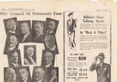
Yields information about Ballarat and its locations or environs late 1938.Pages 21,22,29 and 30 of the Centenary issue of the Ballarat Courier, 8/3/1938. Page 21 "When the World was Wide", photos, Ballaarat City Council of Centenary of settlement in the Ballarat district, year, and Sturt St. from Bridge St., possibly original photo of time. Ads. - Marks & Phillips, - Tailors and C.J.Coles. Page 22 - Towns that have a history - Learmonth, Clunes, Creswick and Buninyong. Photos - Learmonth, Clunes and Forestry school Creswick. Ads - State Savings Bank of Vic, Swanston Used Cars. Page 29 - Ballarat's historic Sports Grounds - origin and development, Eastern Oval incident, listing of nuggets found and quartz specimens. Ads for Prestige stockings, T&G Mutual Life and Fosters Lager. Photo of mine at No. 6 shaft on Band of Hope and Albion Consolidated. Page 30 - articles - Ballarat's sporting origins and swamp to reservoir (water supply). Photos of First England Cricket team to visit Ballarat and aqueduct at Kirks storage basin. Ads for Craig Bros, Pratts cash stores, Haymes paints and Ballarat Block Arcade - shops. Record reviewed and images of some of the pages added 10-9-2013trams, tramways, ballarat centenary celebrations, centenary, sports ground, water supply -
 Eltham District Historical Society Inc
Photograph, Liz Pidgeon, Heritage Excursion; Maroondah Aqueduct, 3 September 2016, 3 September 2016
Heritage Excursion - Maroondah Aqueduct Walk - Saturday 3rd September The Maroondah Aqueduct was once a major link in Melbourne’s water supply system. It was built between 1886 and 1891 to transfer water from the Watts River near Healesville to the Preston Reservoir. It was 66 km in length, made up of 41 km of open channel, 10 km of tunnel through hills and 15 km of pipeline across stream valleys known as inverted siphons. The section of the aqueduct through the Eltham area has been abandoned since the 1980s but the open channel has largely been retained. A recreational path follows the aqueduct reserve. For our excursion on 3rd September we intend to walk along the section of the aqueduct adjacent to Allendale Road. This is a section not visited on previous excursions and includes the transition from open channel to the inverted siphon across the Diamond Creek valley. Apart from the aqueduct itself the main feature of the walk is the extensive views across Eltham North and Diamond Creek. Along the way we will talk about the history of the aqueduct and the area. This easy walk is about 3 km return and will take 2 to 2.5 hours. It will start at 2pm at the junction of Allendale Road with Godber Road and Zig Zag Road North, officially Diamond Creek, but on the northern boundary of Eltham. (Melway ref.12 B10). Newsletter No., 229, August 2016 Abandoned and rusted house base probably purposed to water or feed cattle. Born Digitalmaroondah aqueduct, eltham north, activities, eltham district historical society, heritage excursion, bath, acqueduct trail