Showing 24132 items
matching road districts
-
 Ringwood and District Historical Society
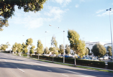
Photograph, Eastland, Ringwood in June 2002, from Warrandyte Road, Ringwood facing west, over the former car park. Showing Safeway (far left) and Myer (right)
Photographic record by Russ Haines, RDHS, in October 2008. -
 Ringwood and District Historical Society
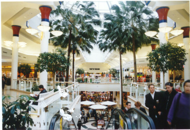
Photograph, Interior of Eastland, Ringwood in June 2002
-
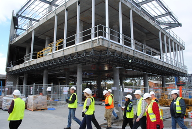
 Ringwood and District Historical Society
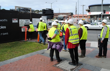
Photograph, Preparing for a Probuild tour of Stage 5 building of Eastland, Ringwood in 2015. Assembly point was located where the new REALM library was going to be built. Railway Station and offices in background
Photographs taken by Jeff Leipold, member of RDHS -
 Ringwood and District Historical Society
Photograph, Probuild tour of Stage 5 building of Eastland, Ringwood in 2015. Showing new escalators at entrance to new Eastland. The REALM library being built on left. Railway Station and offices in background
Photographs taken by Jeff Leipold, member of RDHS -
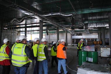 Ringwood and District Historical Society
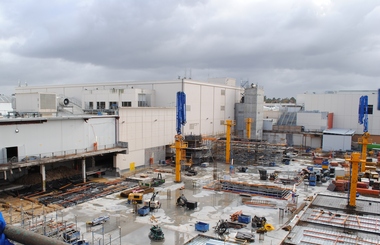
Photograph, Probuild tour of Stage 5 building of Eastland, Ringwood in 2015. Showing interior of new Eastland
Photographs taken by Jeff Leipold, member of RDHS -
 Ringwood and District Historical Society
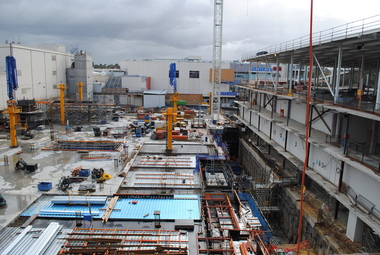
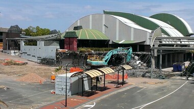
Photograph, Probuild tour of Stage 5 building of Eastland, Ringwood in 2015. Showing structures near REALM library
Photographs taken by Jeff Leipold, member of RDHS -
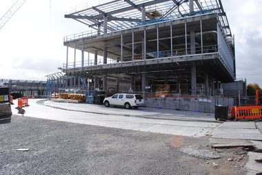
 Ringwood and District Historical Society
Photograph, Probuild tour of Stage 5 building of Eastland, Ringwood in 2015. Showing upper storey structures
Photographs taken by Jeff Leipold, member of RDHS -
 Ringwood and District Historical Society
Photograph, Probuild tour of Stage 5 building of Eastland, Ringwood in 2015. Showing upper structures of REALM library
Photographs taken by Jeff Leipold, member of RDHS -
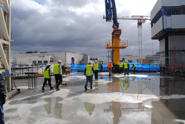
 Ringwood and District Historical Society
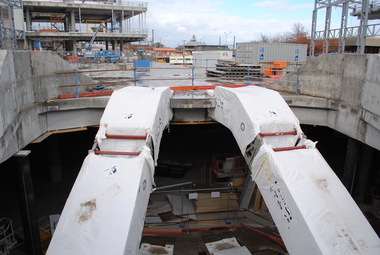
Photograph, Probuild tour of Stage 5 building of Eastland, Ringwood in 2015. Looking down from upper floors
Photographs taken by Jeff Leipold, member of RDHS -
 Ringwood and District Historical Society
Photograph, Probuild tour of Stage 5 building of Eastland, Ringwood in 2015. Looking down on construction work from upper floors
Photographs taken by Jeff Leipold, member of RDHS -
 Ringwood and District Historical Society
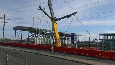
Photograph, Contruction work at the Ringwood Railway Station circa 2014
Photographs taken by Terry Ahern in 2008-2014, member of RDHS -
 Ringwood and District Historical Society
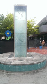
Photograph, Water feature in Melbourne Street, Ringwood. Contruction work beginning at the Ringwood Railway Station and Stage 5 of Eastland circa 2014
Photographs taken by Terry Ahern in 2008-2014, member of RDHS -
 Ringwood and District Historical Society
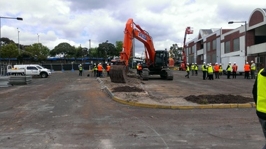
Photograph, Removal of car park at former Adelaide Street, Ringwood. Preparation for construction work beginning at the Ringwood Railway Station and Stage 5 of Eastland circa 2014
Photographs taken by Terry Ahern in 2008-2014, member of RDHS -
 Ringwood and District Historical Society
Photograph, Removal of Ringwood library and surrounds. Preparation for construction work beginning at the Ringwood Railway Station and Stage 5 of Eastland circa 2014
Photographs taken by Terry Ahern in 2008-2014, member of RDHS -
 Ringwood and District Historical Society
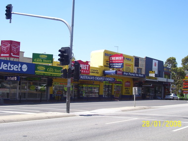
Photograph, Former shops to the east of Melbourne Street in January 2008. Knocked down in later preparation for construction work beginning at the Ringwood Railway Station and Stage 5 of Eastland circa 2014
Photographs taken by Terry Ahern in 2008-2014, member of RDHS -
 Ringwood and District Historical Society
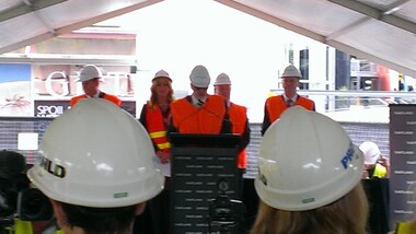
Photograph, Officially opening of Stage 5 of Eastland circa 2014, with Maroondah City Council Mayor Nora Lamont
Photographs taken by Terry Ahern in 2008-2014, member of RDHS -
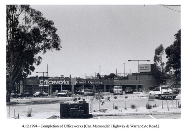 Ringwood and District Historical Society
Photograph, Officeworks at the corner of Maroondah Highway and Warrandyte Road. Opening sale on 4 December 1994. Looking east over the Eastland car park
-
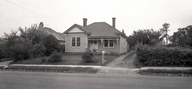 Ringwood and District Historical Society
Photograph, House of Roy Wilkins at 40 Ringwood Street, Ringwood. Roy was a Ringwood Councillor and local builder (Blood Bros. Store and Oliver Pratt's butcher)
-
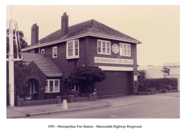 Ringwood and District Historical Society
Photograph, Ringwood Fire Station, Maroondah Highway, Ringwood in 1993. Metropolitan Fire Brigade, with central fire station and two officer's residences
-
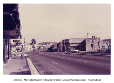 Ringwood and District Historical Society
Photograph, Looking west along Maroondah Highway, Ringwood on 22nd August 1993. Wantirna Road intersection, with SEC building and Ringwood Street on right
-
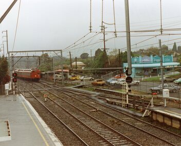 Ringwood and District Historical Society
Photograph, Ringwood Railway Station on 3rd October 1992, showing a Tait train and Blood Bros. Store
Taken by Roy J Mitchell, local railway worker -
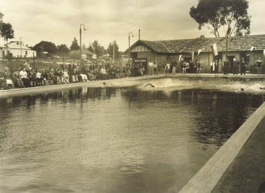 Ringwood and District Historical Society
Archive - Parent Record, Ringwood Municipal Baths, Ringwood Street, later Swimming Pools and Aquatic Centres ,and Ringwood Swimming and Lifesaving Club- Archive Collection
Parent Record for Archive collection of photographs and documents relating to Ringwood Municipal Baths in Ringwood Street, Ringwood. (Also covers later Swimming Pools and Aquatic Centres in Ringwood) -
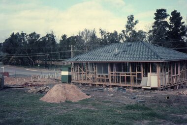 Ringwood and District Historical Society
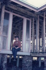
Photograph, Building the Mitchell house at 168 Oban Road, North Ringwood circa 1973
Rear view of the house, partially completed. On the left is the corner of Cormistom Road and Florence Avenue onto Oban Road. The house is still there today (2024).Taken by Roy J Mitchell -
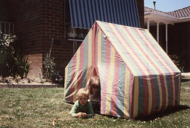 Ringwood and District Historical Society
Photograph, Children on front lawn of the Mitchell house at 168 Oban Road, North Ringwood circa 1983
The house is still there today (2024).Taken by Roy J Mitchell -
 Ringwood and District Historical Society
Photograph, Marian Mitchell at the Mitchell house at 168 Oban Road, North Ringwood circa 1973
The house is partially completed. The house is still there today (2024).Taken by Roy J Mitchell -
 Ringwood and District Historical Society
Document - Folder, Commercial and Retail Property Sales Information, Civic Place and Melbourne Street, Ringwood - 1998
45 photocopied pages including - Plan of Subdivision No.LP80718, Parish of Ringwood, Victoria, Crown Portion 12(Part) and part of a former government road Ref Vol 8668 Fol 745. - Vendors Statement, Planning Certificate and Heritage Council (Victoria) Certificate issued for 20 Melbourne Street, Ringwood. - Maroondah City Council Land Information Certificate for 149 149A and 149B Maroondah Highway; number 8 Civic Mall; and numbers 16, 20, 22 & 24 Melbourne Street Mall. - Yarra Valley Water statements relating to encumbrances for Shop 11, 149 Maroondah Highway; Shop 10, 149A Maroondah Highway; Shop 9, 149B Maroondah Highway; numer 8 Civic Place; Unit 3, 20 Melbourne Street; Office 4, 20 Melbourne Street; Shop 7, 22 Melbourne Street; and Shop 8, 24 Melbourne Street. - Land Tax Certificate pertaining to Commonwealth Bank, Civic Place, Ringwood. - Certificate of Title Vol 8892 Fol 906, Lot One on Plan of Subdivision No. 80718, Parish of Ringwood - Hanover Developments P/L - 29th June, 1971. -
 Ringwood and District Historical Society
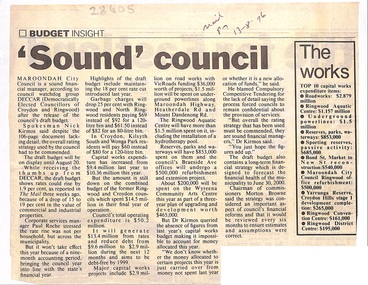
Newspaper, Scrapbook Clipping, Library Collection, Ringwood, Victoria
Newspaper Clipping from the "Mail", 13-08-1996. P7. "Sound" councilMaroondah City Council is a sound financial manager according to council watchdog group DECCAR (Democratically Elected Council of Croydon and Ringwood) after the release of the council's draft budget. Spokesman Nick Kirmos said despite the 106 page document lacking detail, the overall rating strategy used by the council had to be commended. -
 Phillip Island and District Historical Society Inc.
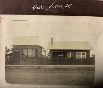
Photograph, Our house, 1925-1926
Possibly in shopping area of Cowes.Small sepia photograph of two buildings beside unmade road. On left is a small shop, that looks empty. On right is a small timber house with a metal roof.Our housephotographs, homes and haunts, cowes shop buildings -
 Phillip Island and District Historical Society Inc.
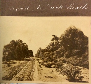
Photograph, Road to the Back Beach, 1925-1926
Sepia photograph of an rough, sandy, unmade road with trees and bushes along the side.Road to the Back Beachphotographs, phillip island early roads -
 Phillip Island and District Historical Society Inc.
Photographs, Cowes Primary School Opening, Circa 1950s
School was previously located in Thompson Ave. Cowes. The opening was in August 1954Five coloured photographs of the Cowes Primary School new Campus in Settlement Road, opening.cowes primary school settlement road, opening of cowes primary school settlement road, anne davie