Showing 2472 items matching " township"
-
 Sunbury Family History and Heritage Society Inc.
Photograph, 1935
The waterfall is in Jacksons Creek downstream from the Sunbury township.A black and white photograph with a cream border of a waterfall in a river. A gnarled tree is growing on the bank and there is a hill in the middle distance.waterfalls, jacksons creek, sunbury -
 Clunes Museum
Book - ADMINISTRATIVE REPORT, JOHN TAYLOR & SON, REPORT ON THE CLUNES GOLD FIELD STATE OF VICTORIA, AUSTRALIA, 1935
WRITTEN REPORT OF JOHN TAYLOR AND SONS, LONDON OF THE EXAMINATION OF THE PROPOSAL TO REOPEN THE GOLD MINES SITUATED IN THE TOWNSHIP OF CLUNES...HARDCOVER BOOK CONTAINING REPORTS BY THE MINING REGISTRARS WITH MAPS OF THE CLUNES GOLD FIELDWRITTEN REPORT OF JOHN TAYLOR AND SONS, LONDON OF THE EXAMINATION OF THE PROPOSAL TO REOPEN THE GOLD MINES SITUATED IN THE TOWNSHIP OF CLUNES...gold mining, commercial report, clunes mines to reopen, 1935 -
 Bendigo Historical Society Inc.
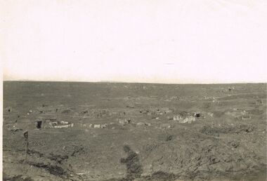
Photograph - ACC LOCK COLLECTION: B&W PHOTO OF A BATTLEGROUND WITH TOWNSHIP IN DISTANCE, PHOTOGRAPH, 1914-1918
Photograph, WW1, B&W photo of a desolate battleground showing gun positions and a township in the far left distance. Handwritten in pencil on the back Gun positions from the duckboards S985 114 114photo, photo, ww1, france, battleground -
 Hume City Civic Collection
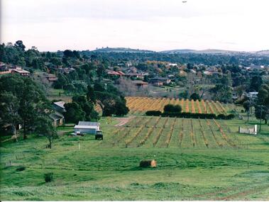
Photograph, late 1980s
'Craiglee' Winery was established by James Stewart Johnstone in 1865 and the property continued to function as a winery until the late 1920s. The vines were uprooted and the property was used for wool and fat lamb production. In 1961 the Carmody family purchased the property and in 1976 re-established the vineyard.A coloured landscape photograph overlooking Craiglee Winery and vineyard as well as the Sunbury township and its surrounding hills north of the town. A roll of hay is in the foreground and a tractor near out buildings is to the LHS of the photograph.wineries, vineyards, johnstone, james stewart, carmody, patrick, 'craiglee' winery, george evans collection -
 Hume City Civic Collection
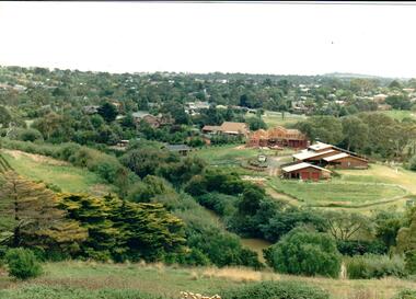
Photograph
Housing development spread to the banks of the Jacksons Creek at the east end of the town in the late 1970s.A coloured landscape photograph overlooking the Jacksons Creek and Sunbury township and showing housing development which is taking place on the horse shore bend also known as blueberry island on the opposite creek bank.jacksons creek, blueberry island, george evans collection -
 Hume City Civic Collection
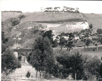
Photograph, Early 1970s
The Kaolin Quarry at Bulla supplied Kaolin to the Northcote and Brunswick Pottery Works until it ceased operation at that site in the 1950s. The three arched bluestone bridge r3placed a ford crossing across Deep Creek, which along with Jacksons Creek flows into the Maribyrnong River.A black and white photograph of the Deep Creek and three arched bluestone bridge in the Bulla Township with the Kaolin Quarry in the background. One truck is crossing the bridge with a tanker approaching the bridge at the bottom of the Bulla Hill.deep creek, bridges, kaolin quarries, quarries, george evans collection -
 Clunes Museum
Photograph
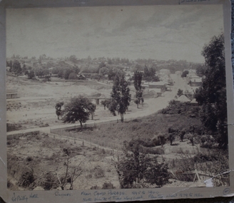
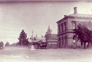
.1 BLACK AND WHITE PHOTOGRAPH OF CLUNES TOWNSHIP - FRASER STREET FROM CAMP PARADE C 1897 .2 BOOKLET WITH CREAM COVER TITLE: "A COLLECTION OF HYMNS AND SOLOS FOR SUNDAY SCHOOL ANNIVERSARIES" .1 On Reverse; CLUNES FROM CAMP PARADE ABOUT 1897 On Front; Handwritten in blue ink Port Phillip Hotel - Clunes - From Camp Parade 1895-1900 *Note growth of trees along creek. Planted about 1879 to 1880. Seven Stars Hotel at bend in Fraser Streetlocal history, photography, photographs, clunes township -
 Clunes Museum
Photograph
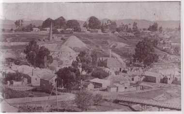
BLACK AND WHITE PHOTOGRAPH OF CLUNES TOWNSHIP. SMOKE STACKS, MULLOCK HEAPS, TWO POPPET HEADS, TWO BRIDGES OVER CREEK, DWELLINGS. SEVERAL LARGE TREES AND SMALLER TREES IN TREE GUARDS.local history, photography, photographs, clunes township -
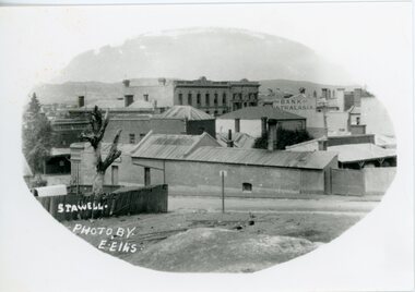
 Stawell Historical Society Inc
Photograph, Panorama of Stawell from Big Hill -- Coloured
Colour Laminated photograph and timber framed view of Stawell from Big Hill. c 1998 The Town Hall is at the center of photograph and the National Hotel on the left. The back of buildings can be seen at top of Main Street. Laminated and Framed photograph taken by Irene Read in c 1998 showing view of Stawell from Big Hill -- The Coloured photograph can be identified by trees in the foreground, Stawell township and mountains in background.stawell, panorama, streetscape -
Lakes Entrance Historical Society
Book, Tract Consultants Australia Pty Ltd and J L Sach and Associates Pty Ltd, Shire of Tambo Strategy Plan 1986, 1986
A development strategy plan prepared by Tract Consultants and J L Sach and Associates, for the Shire of Tambo, focusing in particular on the townships at the Eastern section of the Gippsland Lakes. Minimal consideration is given to the Buchan areagovernment, tourism -
 Clunes Museum
Photograph
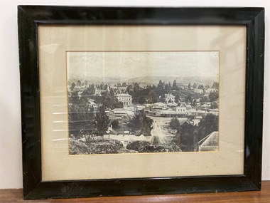
BLACK AND WHITE FRAMED PHOTOGRAPH OF THE TOWNSHIP OF CLUNES LOOKING OVER BRIDGE TO SERVICE STREET AND FRASER STREET CORNER, SHOWING TOWN HALL, OLD POST OFFICE, WESLEY CHURCH, UNICORN HOTELservice street, fraser street, clunes streets -
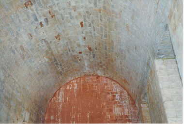 Clunes Museum
Photograph, KODAK, 1999
VIEW OF POWDER MAGAZINE USED IN MINING DAYS TO STORE EXPLOSIVES. BUILDING MATERIALS SOLID BRICKCOLOURED REPRINT PHOTOGRAPH OF POWDER MAGAZINE EXTERIOR. SITUATED IN A PADDOCK ON SMEATON ROAD APPROX. 2 KM. FROM TOWNSHIP ON LEFT HAND SIDE. SHOWING BRICKED ARCHED ROOF AND END WALL.photography, photographs, mining, powder magazine -
 Kiewa Valley Historical Society
Folder - Early Photos of Mt Beauty
Mt Beauty township was built during the 1950's to house the employees of the State Electricity Commission working on the Kiewa Hydro Electric Scheme. After the completion of the Kiewa Hydro Electric Scheme many houses were sold and the public buildings handed over to the Alpine Shire. Mt Beauty has always been a tourist destination especially with its proximity to the ski fields at Falls Creek.This folder contains many early photos of Mt Beauty showing the construction town during its development during the Kiewa Hydro Electric Scheme and its early days of tourism. A3 size black plastic folder with clear plastic sleeves holding early black & white photos of Mt Beauty township. Also included are: 1. 3 foolscap pages -Nov., 1953 Kiewa Hydro-Electric Scheme Progress. 2. SECV Drawing Plan (No. K6242) of Mt Beauty House - 3 angles and floor plan, English Pre-cut Type 3B.ILA with note that all houses with prefix 3B are similar. 3. Orange, black and white pamphlet "Welcome to Kiewa" 4. Tourist postcard 'fold-up' of 11 postcards "Mt Beauty and the Kiewa Scheme, Victoria 5. Drawing Plan of 'Mt Beauty Housing. Use of Prefabricated Cubicles for Houses. Type C.1 6. Drawing Plan of 'Kiewa Scheme Mt Beauty Housing Type "G". 7. 5 pages on "Twelve Tips on Caring for Old Buildings 8. Booklet advertising Mt Beauty housing for sale including activities available in the area. (1960's) 9. List of Photos from SECV held by KVHS Some photos have handwritten labels mt beauty. secv. kiewa hydro electric scheme.tourism. housing. construction town. falls creek. -
 Stawell Historical Society Inc
Photograph, Upper Main Sstreet Stawell
B/W photo view of township upper main streetstawell -
 Kiewa Valley Historical Society
Photo Framed - Tawonga South, c1940's
Tawonga South was situated between the rural township of Tawonga and the State Electricity Commission of Victoria's construction town of Mt Beauty. The building in the fore ground of the photo was built before the Mt Beauty township was built as the occupier was working on the Kiewa Hydro Electric Scheme.The Barters came to work on the State Electricity Commission of Victoria's Kiewa Hydro Electric Scheme before housing in the town of Mt Beauty was built. The Barters rudimentary dwelling was probably not a legal building. The photo was taken by Vera Hore (nee Ryder), the publican at the Bogong Hotel near Tawonga South where the photo was taken. Vera, 1909 - 2000, was a keen amateur photographer.Colored photo of Tawonga South with a dwelling in the bottom of the right hand corner and Mt Bogong, covered in snow, at the top. Framed with cream card board 1 cm wide and a metal decorated frame surrounding it.On the back - "Vera Hore"tawonga south; vera hore; mt beauty -
 Kiewa Valley Historical Society
Papers - Tawonga & Mt Beauty
Red Cross, CWA, Bowling Club histories in Tawonga and Mt Beauty written for a book, title unknown.The histories of the Red Cross, the Country Women's Association and the bowling clubs in the towns of Tawonga and Mt Beauty are important as the communities in the Kiewa Valley were involved in these organisations for many years from the mid 1940's and in the case of the Tawonga bowling club since 1953. The number of people, their activities and infrastructure associated with the clubs give an insight into how people lived during the times that the clubs existed.Papers from chapter 4 entitled 'Community Organisations' and chapter 5 entitled 'Recreational Activities & Opportunities' from an unknown book. These cover the townships of Tawonga and Mt Beauty and include black & white photos.red cross, country women's association, bowling clubs, mt beauty, tawonga -
 Kiewa Valley Historical Society
Photo - Early photo of Bogong Township x2
Bogong Village was built for the workers of the State Elecricity Commission of Victoria who were employed to construct the Kiewa Hydro electric Scheme. This photo shows their homes and offices etc., Lake Guy and the spillway during construction days.Bogong village was built as part of the Kiewa Hydro Electric Scheme. This photo gives a view of the village when it was at its peak. Large photo of Mt Bogong Township with snow on the mountain in the background and the spillway over-flowing in the foreground. Some small trees amongst those burnt by the 1939 bushfire. (2 photos - one an enlarged copy)bogong village. kiewa hydro electric scheme. s.e.c.v.. lake guy. -
 Phillip Island and District Historical Society Inc.
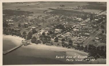
Photograph - Post Card, Early 1900's
Photograph donated by Les JonesBlack & White postcard of an aerial view of Cowes. Jetty on the left - tree lined Thompson Avenue - Isle of Wight Hotel on the Esplanade left of Thompson Avenue and Bayview Guesthouse on the right on the Esplanade. Township and farmland."Aerial View of Cowes, Phillip Island. No. 147"aerial view of cowes phillip island, cowes township, part cowes township - cowes beach and jetty, phillip island, les jones -
 Halls Gap & Grampians Historical Society
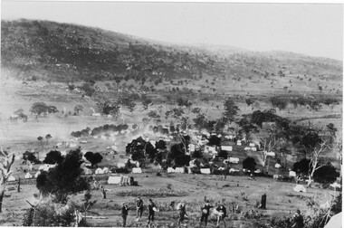
Photograph - Sepia, C 1900
Mount William Gold Rush Photo taken from Spion Kop looking at western side of My WilliamView of township called Ladysmith George Mason's farmhouse in centre of picture with smoke rising from chimney Seven men in foreground carrying various items eg. shovel, gold pan, swag etc.1 copy B/W 1 copy sepia 1 on displaymining, gold mining, mafeking -
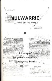 Bendigo Historical Society Inc.
Book - STRAUCH COLLECTION - MULWARRIE (A TOWN ON THE RIVER) A HISTORY OF BRIDGEWATER-ON-LODDON TOWNSHIP AND DISTRICT 1836-1971, 1971
Mulwarrie (A Town on the River) A History of Bridgewater-on-Loddon Township and District 1836 - 1971 Published by back to Bridgewater committee 80 pages with black and white photographs. Printed by Jim Lowden printing Kilmore 3601.victoria, history, bridgewater-on-loddon -
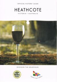 Bendigo Historical Society Inc.
Book - HEATHCOTE: OFFICIAL VISITORS' GUIDE
Heathcote - Official Visitors' Guide. 18 page coloured booklet published by Heathcote Tourism and Development Inc. 2005. Attractions and activities in Heathcote area; accommodation options; dining. Includes map of township and nearby.Bart n Printvictoria, history, regional history., heathcote visitors guide -
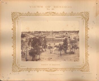 Bendigo Historical Society Inc.
Photograph - VIEWS OF BENDIGO: TOWNSHIP OF EAGLEHAWK, c. 1870's
Photograph No. 37. Sepia photograph of township of Eaglehawk, showing main street, Town Hall and Post Office. Also printed below photo, Forbes & Holmes, Agents, Casey & Wenborn's Print. Nicholas CaireN.J. Caire - Sandhurstplace, eaglehawk -
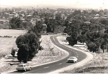 Hume City Civic Collection
Photograph, Early 1970s
In the early 1970s the eastern approach to Sunbury was changed. The stone bridge spanning the Jacksons Creek was replaced by a wider concrete structure and dangerous curves were taken out of the road. The area on the LHS of the photograph including the two arched stone bridge has been incorporated into a public picnic area.A black and white panoramic view of the eastern approach to Sunbury and the Sunbury township before the road was widened and straightened and the new bridge was built. There are two cars in the foreground. One is approaching the bridge and the other is leaving Sunbury.macedon street, macedon street road bridge, jacksons creek, sunbury township, george evans collection -
Clunes Museum
Magazine - BOOK / MAGAZINE, FPC. LIVING - A DIVISION OF EASTERN SUBURBS NEWSPAPERS, Aug-01
COLOURFUL MAGAZINE - AUSTRALIAN COUNTRY STYLE, CONTAINING ARTICLE -PAGE 90- BUILT ON GOLD. PHOTOGRAPH OF CLUNES TOWNSHIP, CEILING IN CLUNES TOWN HALL, MRS. PAT COOK IN FRONT OF CLUNES TOWN HALL.local history, books, magazine -
 Clunes Museum
photograph, 1914
.1 BLACK AND WHITE PHOTOGRAPH OF CLUNES TOWNSHIP TAKEN FROM SERVICE STREET,CLUNES, SHOWING POST OFFICE .2 .3 BLACK AND WHITE COPIES OF THE ABOVE PHOTOGRAPH PRINTED ON GLOSS PHOTOGRAPHIC PAPERCLUNES 14local history, photography, photographs, post office -
 Clunes Museum
photograph, 1967
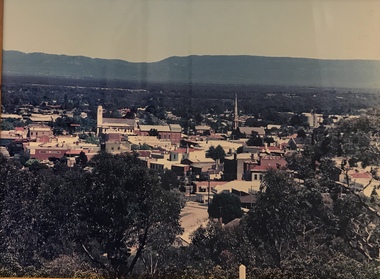
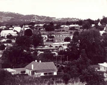
BLACK AND WHITE PHOTOGRAPH OF CLUNES TOWNSHIP TAKEN CIRCA 1967. PHOTOGRAPH TAKEN FROM SCENIC ROAD FACING SOUTH, BUILDINGS INCLUDE POST OFFICE, METHODIST CHURCH, ST. THOMAS PRESBYTERY ETC.local history, photography, photographs, clunes township -
Whitehorse Historical Society Inc.
Article, Nunawading's electric light scheme, 14 August 1914
Inauguration of electric lighting in the Shire of Nunawading at the substation cnr Whitehorse Road and Station Street, Box Hill,Copy of The Reporter, Friday August 14, 1914 article on the Inauguration of electric lighting in the Shire of Nunawading at the substation cnr Whitehorse Road and Station Street, Box Hill, includes the townships of Blackburn, Tunstall and Mitcham.Inauguration of electric lighting in the Shire of Nunawading at the substation cnr Whitehorse Road and Station Street, Box Hill,electricity supply, lincolne and macdougall, wright, g.f., melbourne electric supply company, garrett, h.t. -
 Otway Districts Historical Society
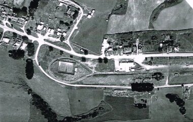
Photograph, R. Preston, Aerial view of Beech Forest railway station and yards, 1965, 13 February 1965
B/W. An aerial view of Beech Forest showing the balloon loop at the end of the station yard (enclosing the two tennis courts), two ex-departmental residences, the station buildings, and other aspects of the township.beech forest: railways; township; aerial; -
 Wodonga & District Historical Society Inc
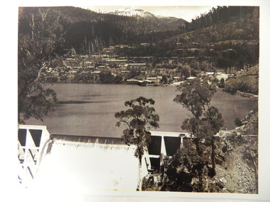
Album - Hume Reservoir Australia Album - General view of earth embankment in Victoria, October 1924
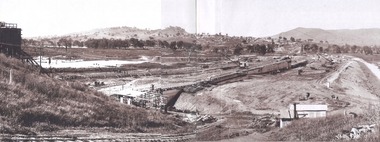
This set of photos is from a leather bound album bearing the inscription "HUME RESERVOIR AUSTRALIA" plus 'The Rt. Hon. L. C. M. S. Amery, P. C., M .P.' all inscribed in gold. It was presented to The Rt. Hon. L. C. M. S. Amery, P. C., M. P, Secretary of State for Dominion Affairs on the occasion of his visit to the Hume Reservoir on 2nd November 1927. This album is of local and national significance as it documents the planning and development of the Hume Reservoir up to 1927. It was the largest water reservoir in the British Empire. The album records the pioneering engineering work that went into its construction.DEPARTMENT OF PUBLIC WORKS, N.S.W. RIVER MURRAY WATERS SCHEME. HUME RESERVOIR. 17. General view of earth embankment in Victoria. New South Wales section of work and Township beyond. October 1924.hume reservoir australia, river murray waters scheme, hume reservoir construction -
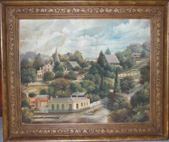 Clunes Museum
Painting - PAINTING-OIL ON CANVAS, RICHARD FORD
OIL PAINTING OF CLUNES TOWNSHIP BY RICHARD FORD - FRAMED. PAINTING DEPICTS CORNER OF FRASER STREET AND TEMPLETON STREET AND SHOWS THE TOWN HALL, WESLEYAN CHURCH, ST THOMAS AQUINAS CHURCH, AND THE UNION BANK.artwork, richard ford, oil on canvas, churches