Showing 199828 items matching "12-errard-street-south"
-
 National Wool Museum
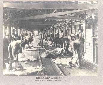
Photograph, Shearing Sheep, New South Wales, Australia
Photo depicts the interior of a shearing shed with shearing taking place. The shed is located in New South Wales and this photo would appear to date from the turn of the century. Presumably the Philadelphia Museum inscription on the front indicates that either this photo is from their collection (unlikely) or that it was commissioned by them for selling / distribution.Photograph, 'Shearing Sheep', 1900-10 (Philadelphia Museum). Caption on reverse of photograph - 'Shearing Sheep', (Philadelphia Museum) c.1900-10.SHEARING SHEEP / NEW SOUTH WALES, AUSTRALIA / THE PHILADELPHIA MUSEUMshearing shearing sheds, philadelphia museum, shearing, shearing sheds -
 Vision Australia
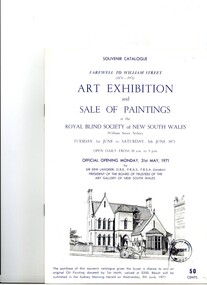
Booklet - Text, Souvenir catalogue Farewell to William Street (1876-1971) Art exhibition and sale of painting at the Royal Blind Society of New South Wales, 1971
As a way of raising funds, an art exhibition and sale of paintings was held at the William Street offices of the Royal Blind Society before they moved to their new offices in Enfield. This was one of a series of events held to say goodbye to the former building and to pay for the creation of purpose built offices outside of the CBD. 6 page booklet providing a brief history and overview of current situation, including a list of auction itemsroyal blind society of nsw, fundraising -
 Ringwood and District Historical Society
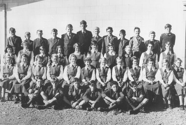
Photograph, Ringwood High School - 1954, Form 1A. Boys standing (L-R): 1. Ian Kilpatrick, 2. Keith Anderson, 3. Peter Zaff, 4. Jim Ord, 5. Gordon Burnett, 6. Tim Pinninger, 7. Geoff Giggings, 8. Bernard Whitney, 9. Andrew Termouth, 10. Clive Kettle, 11. Robert Tozar 12, Frank Stubbs. Girls standing: 1. Janet Johns, 2. Norma Walsh, 3. Marilyn Bird, 4. Doris Hemell, 5. Lynette Jungwirth, 6. Janice Hunt, 7. Sandra Davenport, 8. Margaret Williams, 9. Margaret Norwood, 10. Lorrice Stratton. Girls seated: 1. Kathleen Lowe, 2. Valma McLean, 3. Sandra Tyndal, 4. Gillian Morris, 5. Esma Bradley, 6. Jill Pump, 7. Judy Byrne, 8. Shirley Kofeod, 9. Marlene Mangels, 10. Pam Erlandsen, 11. Myrna Cooper, 12. Elizabeth Hinchcliffe. Boys seated: Robert Crutchfield, 2. Stuart Barclay, 3. James McAleese, 4. Robert Horkings, 5. John Smart, 6. Ronald Crutchfield
+Additional Keywords: Reading from Left to Right: Back row boys: 1. Alan Carter, 2. ??, 3. Maurice Henry, 4. Peter Van Ketwich, 5. Douglas Hume, 6. ??, 7. John Callam, 8. ??, 9. ??, 10. ??, 11. Peter Gluth, 12. ??, 13. Geoff Edwards, 14. Len Armfield, 15. Ray Davidson".(incorrect list)Written on backing sheet, "Ringwood High School. 1956?" No children are identified.Paper list with photographs reads, "High School - Bedford Rd. Ringwood. Photo Pupils Form 1C. Reading from Left to Right. Back row boys: 1. ?, 2. Keith Anderson, 3. Peter Zaff, 4. Jim Ord, 5. ?, 6. ?, 7. ?, 8. Bernard Whitney, 9. ?, 10. ?, 11. ? 12, ?. Boys sitting front: Robert Crutchfield, 2. ?, 3. ?, 4. ?, 5. John Smart, 6. Ronald Crutchfield. Girls standing: 1. ?, 2. Norma Walsh, 3. ?, 4. ?, 5. ?, 6. ?, 7. Sandra Davenport, 8. Margaret Williams, 9. Margaret Norwood, 10. ?. Girls sitting: 1. Kathleen Lower, 2. Valma McLean, 3. Sandra Tindall, 4. Gilliam Morris, 5. Esma Bradley, 6. Jill Pump, 7. Judy Byrne, 8. Shirley Kofeod, 9. Marlene Mangels, 10. ?, 11. Myrna Cooper, 12. Elizabeth Hinchcliffe. -
 National Wool Museum
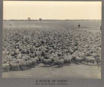
Photograph, A Flock of Sheep, New South Wales, Australia
Photo depicts a flock of sheep being mustered in New South Wales. This photo would appear to date from the turn of the century, like the other, similar photo of sheep shearing. Presumably the Philadelphia Museum inscription on the front indicates that either this photo is from their collection (unlikely) or that it was commissioned by them for selling / distribution.Photograph of a flock of sheep, NSW, c.1900-10 (Philadelphia Museum). Caption on reverse of photograph - A Flock of Sheep (Philadelphia Museum), 1900-10.A FLOCK OF SHEEP / NEW SOUTH WALES, AUSTRALIA / THE PHILADELPHIA MUSEUMsheep - australian, philadelphia museum -
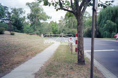 Eltham District Historical Society Inc
Photograph, Looking south along Main Road from the Avenue of Honour near Dalton Street, Eltham South, c.1989, 1989
Roll of 35mm colour negative film, 5 stripsKodak GA100 5095avenue of honour, dalton street, eltham, infrastructure, main road, streets -
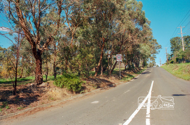 Eltham District Historical Society Inc
Photograph, Looking south along Bolton Street, Eltham just south of intersection with Main Road, c.May 2001
Roll of 35mm colour negative film, 7 stripsAgfa HDC 200 plus-2eltham, streets, main road, fitzsimons lane reserve -
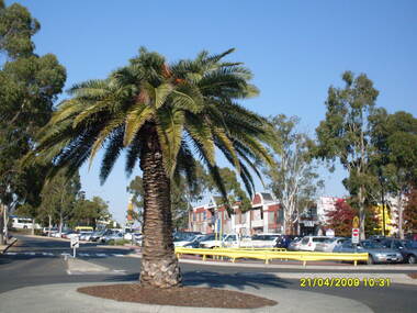 Ringwood and District Historical Society
Photograph, Looking along former Adelaide Street, from the access road roundabout, towards the south, on 21 April 2009. Showing pedestrian crossing to south car park and shops
Ron Brons photographic study of Ringwood. -
 Tatura Irrigation & Wartime Camps Museum
Photograph - sepia, Brooklyn Studio, Mitchell's Bush Inn, pre 1900
Very old sepia colour photograph of Mitchell's Bush Inn.Though to have been beside the flour Mill but definitely in Casey street. Photograph take from the roadway includes the house next door, several people and a horse and buggy with 2 people in. Timber in the background.Brooklyn Studio 495 Chapel Street South Yarra -
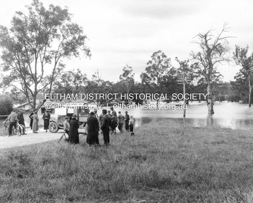 Eltham District Historical Society Inc
Photograph, Main Road, Eltham South, corner of Falkiner Street, flooded by the Diamond Creek, 1934
View of the Diamond Creek flooding across Main Road looking towards Eltham at intersection with Falkiner Street; a Council truck blocking Main Road, Eltham Lower Park on right, Eltham Park Tea Rooms (later Ansell and Muir) on left fooded. The bridge can just be seen on far right centre.Black and white photographmain road, eltham south, ansell and muir, diamond creek (creek), eltham park, eltham park tea room, falkiner street, floods, floodwater -
Tatura Irrigation & Wartime Camps Museum
Photograph - copy, D. Clark, Hogan Street Tatura, 1989 copy
Photograph of Hogan Street, Tatura, looking east. Flanagan's Store on right. Originally a post card.Black and white copy photograph of Hogan Street, Tatura, looking east. c 1940.on back: Hogan Street Taturahogan street tatura -
 Hume City Civic Collection
Manual - Street Directory, Morgan's Official Street Directory of Melbourne and Suburbs, 1980's
This street directory of Melbourne and Suburbs was the 52nd edition published by Val Morgan. It is printed with a new map format.A Morgan's street directory of Melbourne and Suburbs without a front cover.morgan, val and co., melbourne, directories, street directories, george evans collection -
Lakes Entrance Historical Society
Book, Loney Jack, Sea Adventurers and Wrecks on the New South Wales South Coast, 1977
Coastal shipping and some shipwrecks on the south coast of New South Wales, 1826 to 1976. Indexed chronologically, illustratedships and shipping -
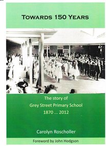 Grey Street Primary School, Traralgon
Book, Towards 150 Years. The story of Grey Street Primary School 1870 ... 2012, 2012
Commissioned to be written in 2012 to coincide with the centenary of the opening of the school at the new site in Grey Street, Traralgon. Includes historical information on the first school in Argyle Street in 1870, and its relocation to Campbell Street in 1872. Chapters are set out in decades. Many historical photos of various classes most of which include pupil and staff names.This book tells the story of the commencement of state education in Traralgon in 1870, and follows the development of Traralgon State School into the present Grey Street Primary School.A4. Cover photo depicting children in quadrangle at official opening of Grey Street Primary School in 1912. Cover printed in full process both sides. Text printed in Black throughout, except 16pp colour, perfect bound and packed. Cover: Towards 150 Years/ The story of/ Grey Street Primary School/ 1870 ... 2012/ Carolyn Roscholler/ Foreword by John Hodgson Spine: Towards 150 Years - Carolyn Roscholler Complete typesetting by Gippsland Printers.grey street., traralgon state school, campbell street, traralgon -
National Wool Museum
Book, South Australia: its history, productions and natural resources, 1883
"South Australia its history, productions and natural resources" - J P Stow, 1883.William J Vandenbergh South Australian Legislature Sold 10-10-95 ..[.]..Library Comm..teewool - history sheep stations - history, wool - history, sheep stations - history -
Port Melbourne Historical & Preservation Society
Education kit, Anna Monea, South Melbourne Gasworks Education Kit, 1997
Duncan King-Smith interviewed 10 former workers who were at the Gasworks from 1920 to 1957. Extracts from these interviews provided the framework for the Education Kit Entered for and (as only entrant) won the Tom Hills Memorial History Prize in 1998. Kit supported by Gasworks Arts, Apple, Australia Foundation, Gas and Fuel Corp. and City of Port PhillipSouth Melbourne Gasworks Education kit prepared in 1997 by Anna Monea (Concept, Development and Creation) with assistance from Rachel Petro (Sound Technician), containing two booklets and one USB memory stick of the same audio content held as a digital file on our Database on the computer.industry, education, anna monea, rachel petro, south melbourne gasworks, tom hills -
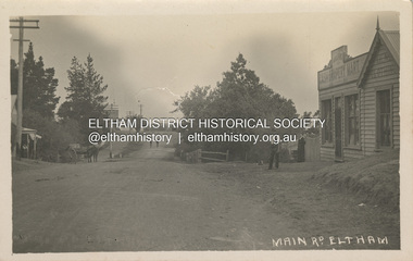 Eltham District Historical Society Inc
Photograph, Main Road, Eltham, looking south from Bridge Street, c.1906-1907
Birthday greetings sent by Mary and Ada Shillinglaw from their home, 'Wattle Brae' at Eltham to their sister Carrie (Watson). Carrie was born 29 Feb 1876. Whilst the postcard was dated 1917, the actual photo is dated between 1906 and 1907. ""Wattle Brae" Eltham 28/2/17 Dear Carrie Wishing you a Bright and a happy birthday. With love from Mary & Ada" See also SEPP_0624 Looking south along Main Road from the south side of the intersection of Bridge Street with Main Road. Anne Hunniford's Post Office and Burgoyne's store on left. Miss Harriet (Minnie) Williams's Cash Drapery Mart (est. 1902 and enlarged in 1906), also known as Eltham House on the right. Harriet (Minnie) Williams was born London, 1857, the daughter of George John Williams (1812-1895) and Jane Mansfield (1812-1895). In September 1885 she was operating Williams’s Drapery Establishment in premises on Main Road owned by R. Wallis who advertised them to let in September 1885. In 1902 she opened Williams’s Cash Drapery Mart at the southwest corner of Bridge Street and Main Road (opposite the Post Office), owned by W.J. Taylor. In 1906 she bought the premises and one quarter acre of land and expanded the business with a re-opening in April 1906. Harriet was also well-known and esteemed as an active worker in Methodist circles and also Superintendent of the Sunday School. Harriet fell ill in August 1907 and died 15 August. She is buried in Eltham Cemetery with her good friend Ada Ford. Evelyn Observer and Bourke East Record (Vic. : 1902 - 1917), Friday 30 March 1906, page 5 ________________________________________ ELTHAM. (FROM OUR OWN CORRESPONDENT.) For over three years Miss Williams has carried on a drapery business in very small and inconvenient premises opposite the Eltham post-office. Recently she bought the building and a quarter-acre of land from Mr. W. J. Taylor. Thus having a free hand, she at once matured plans to enlarge and improve the premises to make them suitable for her growing business. The result being that she consulted Mr Roach, contractor, of Heidelberg, put the matter in his hands, and now he has completed in a very satisfactory manner and up-to-date style extensive improvements. A large addition, of very neat and attractive design, with three large windows, has been built right along the front of the old building, and the counters and inside fittings are very neat and convenient, harmonizing well with the attractive outside appearance. Miss Williams has now got in a large now stock of goods, and is making extensive arrangements for a “reopening week," commencing 2nd April, during which time she will make 10 per cent reduction on all cash purchases in the form of gifts of that value. Miss Williams has gone to considerable expense and liability both, in the enlargement and improvement of the premises and in purchasing additional stock. We therefore trust that the public will stand by her by heartily and en masse patronizing her re-opening effort to show their appreciation of pluck in this advance movement. Google Street View Feb 2017: https://www.google.com.au/maps/@-37.7191341,145.1462046,3a,50.5y,191.91h,88.27t/data=!3m6!1e1!3m4!1sARwwqEQfMSfH9oTWWapPgQ!2e0!7i13312!8i6656 POSTCARD 1905-1940s Like the carte-de-visite, postcards enjoyed a collecting craze by large numbers of people, and were often kept in albums through which the interested visitor could browse. Postcards were posted or exchanged in huge numbers. Postal authorities in Australia only allowed the private printing of postcards from 1898. At this time the back of the card was reserved for the address and postage stamp, and the front was used for the message and a picture. In 1902 British authorities allowed a "divided back", so that the left side could be used for the message, the right side for the address and stamp, and the whole of the front was devoted to the picture. France followed suit in 1904, Germany and Australia in 1905, and the United States in 1907. - Frost, Lenore; Dating Family Photos 1850-1920; Valiant Press Pty. Ltd., Berwick, Victoria 1991marg ball collection, postcard, 1906, 1917, ada maria chrisfield (nee shillinglaw) 1889-1974, ada maria shillinglaw (1889-1974), caroline (carrie) watson (nee shillinglaw 1876-1956), cash drapery mart, eltham, eltham hotel, main road, mary ann shillinglaw (1880-1963), shillinglaw cottage, watsons hotel, wattle brae -
Tatura Irrigation & Wartime Camps Museum
Photograph, Hogan Street Tatura pre 1914, pre 1914 original
Small photograph used on greeting card. Showing Hogan Street, Tatura, looking east. Shops on left, trees, telegraph poles, horses and buggies.Original sepia photograph of Hogan Street Tatura looking east pre 1914Hogan Street Tatura. Greetingshogan street tatura -
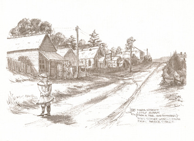 Eltham District Historical Society Inc
Print, Don Brown, Maria Street, Little Eltham (from a pre 1900 photograph) - Main Street looking south from Bridge Street, 1980
Greeting card from Neville Emerson and Staff with sketch commissioned by Neville Emerson Real Estate. Church is Methodist, built 1880. Eltham Hotel is the square building on the left hand side of the road at apex of Maria St, built 1852. Post Office is on the left side of road above the child's head. Note only telegraph lines on top of poles: phone still being "invented". Print of ink sketch, reproduced as greeting cardart, emerson real estate, bridge street, little eltham, main road, maria street, don brown -
 Kew Historical Society Inc
Photograph - A Class 237 in High Street South, 1990
This colour photograph, with 15 others are enlargements gifted to the Society by Mel Lawrence in 2016. They were taken at a commemorative event from the Kew Tram Depot. Laminated colour enlargement of an A Class tram No.237 in High Street South taken at a re-enactment from the Kew Depot in 1990.Annotation reverse: "Kew Depot. A Class 237 in High Street South"kew tram depot, class a trams - melbourne -
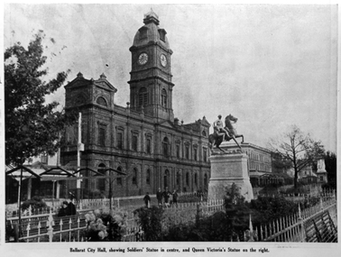 Ballarat Heritage Services
Photograph - Image, Ballarat Town Hall and Sturt Street Gardens, 1922, 1922
The Sturt Street Gardens run down the centre of Ballarat's main street. It boast many statues. In front of the depicted Ballarat Town Hall is the Boer War Memorial which commemorates soldiers who have taken part in the South African War. The scuplture is by James White, and it was proposed by Cr J.J. Brokenshire, and was approved at the Council meeting on 31 May 1900. The foundation stone was laid on May 1901 but was relocated to the present site and re-laid by the then Mayor Brokenshire. The stature was unvelied on 01 November 1906 by the Governor General Baron Northcote.Copy of a photograph showing Ballarat Town Hall, Sturt Street gardens, and the Boer War Monument. ballarat, ballarat town hall, boer war monument, sturt street gardens, boer war memorial, statues -
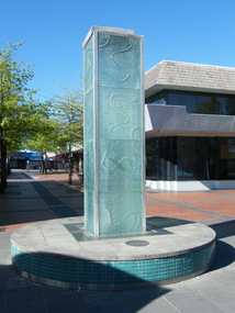 Ringwood and District Historical Society
Photograph, Water feature in Melbourne Street, Ringwood in 2008. It was provided by Maroondah City Council, officially opened on 12 March 1997 to mark the creation of MCC, but rarely having water turned on
Photographic record by Russ Haines, RDHS, in 2008. -
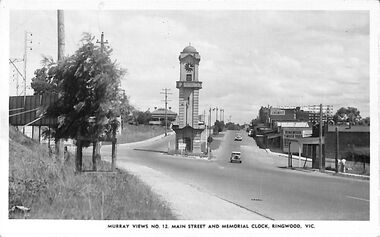 Ringwood and District Historical Society
Photograph/Postcard, Postcard and souvenir photograph - Murray Views No.12. Main Street and Memorial Clock, Ringwood, Vic
Black and white "Murray Views" postcard and souvenir photograph - Ringwood Memorial Clocktower, looking west from cnr. Warrandyte Road and Maroondah Highway, Ringwood, Vic. Circa late 1940s.Printed on back - Post Card - Real Photographs produced in Australia by Murray Views, Gympie, Q. Handwritten - "1949 or 48". -
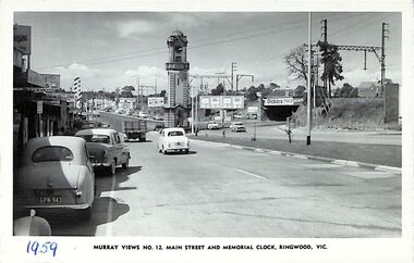 Ringwood and District Historical Society
Photograph/Postcard, Postcard - Murray Views No.12. Main Street and Memorial Clock, Ringwood, Vic
Black and white "Murray Views" postcard - Maroondah Highway looking east towards Memorial Clock Tower on Warrandyte Road intersection; railway bridge on right. Circa 1959."1959" handwritten on front. -
 Ringwood and District Historical Society
Photograph, Adelaide Street, Ringwood, Scots Church Hall on 12 September 1988
Digital photograph -
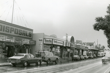 Ringwood and District Historical Society
Photograph, Maroondah Highway, Ringwood on 12 September 1988, showing Ringwood Disposals, Tandy Electronics, TAB and other shops going up to Ringwood Street
Digital photograph -
 Eltham District Historical Society Inc
Slide, Quinn Estate, looking northeast along Sackville Street, Montmorency near no. 12, c.Oct. 1980
One of a series of images of roads and infrastructure focussed on the Quinn Estate in Montmorency taken by Eltham Shire Council Planning and Engineering officers. They provide perspective of the changes in housing styles and road development that began sweeping in from the mid 1970s with increasing urbanisation of what was once more outlying suburbs and regions.35 mm colour positive transparency Mount - Kodak Kodachrome CardProcessed Oct 1980infrastructure, housing estate, montmorency, quinn estate, roads, sackville street -
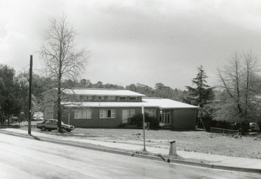
 Eltham District Historical Society Inc
Photograph, 12 and 16 Bridge Street, Eltham, 16 May 2010, 16/05/2010
Colour photographindustries, bridge street, elite panels, nillumbik community health service, rare bears -
University of Melbourne, Burnley Campus Archives
Plan, Nick Moore, Landscape Plan 12 Tyne Street Final Design Assignment, 2005
Coloured plan by Nick Moore dated June 2005. Scale 1:100.nick moore, landscape design -
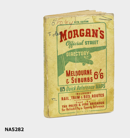 Whitehorse Historical Society Inc.
Map - Street directory, Morgans Official Street Directory
Morgan's street directories lack dates. Donor's parents, who lived in Blackburn, used this street directory .Small soft covered book of official street directory of Melbourne and suburbs.Morgans Official Street Directory Melbourne and Suburbs 6/6maps -
Ballarat Tramway Museum
Document - Photocopies, Photocopies of layout plans of South Melbourne tram depot
Five A3 photocopies of drawings of the South Melbourne tram depot and per way yard. Drawings dated 8/1938. Depot also known as Hanna St. Depot. Sheet A - drawing of per way yard section , drawing P8349. Sheet B - drawing of whole depot and tracks in Hanna St. - drawing P8345. - date 12/8/1938. Sheet C - drawing of entry area and detail plans of administrative blocks - drawing P8346. Sheet D - drawing of south end of yard at corner of Hanna and Bank Streets - overhead and building section - drawing P 8348. Sheet E - drawing of tramcar depot portion of the site, with rolling stock offices and building to the south side of the car shed - drawing P8347, dated 12/8/1938.trams, tramways, south melbourne depot, hanna st. depot, mmtb, depot