Showing 1537 items matching "aerial photograph"
-
 Whitehorse Historical Society Inc.
Map, Mitcham Road, c1970
... Enlarged aerial photograph of intersection of Whitehorse... Aerial photographs Enlarged aerial photograph of intersection ...Enlarged aerial photograph of intersection of Whitehorse and Mitcham Roads, Mitcham. Scale 1 inch : 40 feetEnlarged aerial photograph of intersection of Whitehorse and Mitcham Roads, Mitcham. Scale 1 inch : 40 feetEnlarged aerial photograph of intersection of Whitehorse and Mitcham Roads, Mitcham. Scale 1 inch : 40 feetmitcham road, mitcham, maroondah highway, mitcham, whitehorse road, mitcham, mitcham primary school, no. 2904, mitcham hotel, aerial photographs -
 Federation University Historical Collection
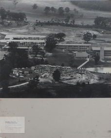
Photographs - black and white, Ballarat College of Advanced Education, Aerial views of the Mt Helen campus from the north, not dated
... 2 black and white aerial photographs .1) Aerial view of Mt... black and white aerial photographs .1) Aerial view of Mt Helen ...2 black and white aerial photographs .1) Aerial view of Mt Helen campus from the north .2) Aerial view from the northmount helen campus, mount helen campus aerial, student residences -
 Koroit & District Historical Society
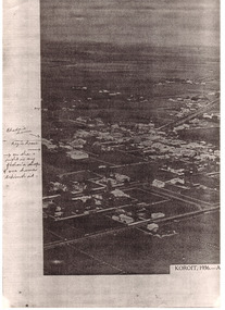
Koroit aerial shot
... photograph. Aerial photograph of Koroit 1936. Writing would probably... of a black and white photograph. Aerial photograph of Koroit 1936 ...PAR0001 to PAR0003 Photocopy of a black and white photograph. Aerial photograph of Koroit 1936. Writing would probably be by Rhoda Hindhaugh formerly Stevenson nee Barr. Souvenir aerial photograph taken by The Argus newspaper 1936. The buildings have been named in pen entered at a later date. -
 Koroit & District Historical Society
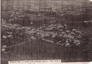
Koroit aerial shot
... photograph. Aerial photograph of Koroit 1936. Writing would probably... of a black and white photograph. Aerial photograph of Koroit 1936 ...PAR0001 to PAR0003 Photocopy of a black and white photograph. Aerial photograph of Koroit 1936. Writing would probably be by Rhoda Hindhaugh formerly Stevenson nee Barr. Souvenir aerial photograph taken by The Argus newspaper 1936. The buildings have been named in pen entered at a later date. -
 Koroit & District Historical Society
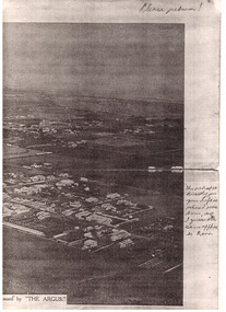
Koroit aerial shot
... photograph. Aerial photograph of Koroit 1936. Writing would probably... of a black and white photograph. Aerial photograph of Koroit 1936 ...PAR0001 to PAR0003 Photocopy of a black and white photograph. Aerial photograph of Koroit 1936. Writing would probably be by Rhoda Hindhaugh formerly Stevenson nee Barr. Souvenir aerial photograph taken by The Argus newspaper 1936. The buildings have been named in pen entered at a later date. -
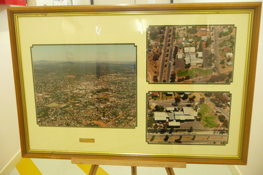 Bendigo Historical Society Inc.
Photograph - BENDIGO NORTH P.S. COLLECTION: AERIAL PHOTOGRAPHS, 1996
... 3 Large aerial photographs of Bendigo North Primary School... PHOTOGRAPH Building bendigo north school 3 Large aerial photographs ...3 Large aerial photographs of Bendigo North Primary School under glass in a timber frame. Deframed 2022photograph, building, bendigo north school -
Port Melbourne Historical & Preservation Society
Photograph - Aerial view of West Gate Bridge, Oct 1990
... Page from 1990 City of Melbourne Strategy Plan with aerial... photograph of West Gate Bridge and Fishermen's Bend Photograph Aerial ...Cut from the 1990 City of Melbourne Strategy PlanPage from 1990 City of Melbourne Strategy Plan with aerial photograph of West Gate Bridge and Fishermen's Bendtown planning, engineering - bridges -
Port Melbourne Historical & Preservation Society
Photograph - Aerial view over Yarra River and Port Melbourne, 18 Jun 1940
... Aerial photograph overlooking the Yarra River with Port... moore ltd north wharf south wharf nordfest Aerial photograph ...Aerial photograph overlooking the Yarra River with Port Melbourne in the middle. Background - Williamstown Road is visible at the top of the picture.piers and wharves - miscellaneous, built environment - commercial, malcolm moore ltd, north wharf, south wharf, nordfest -
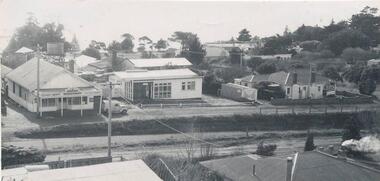
Whitehorse Historical Society Inc.
Map, Deep Creek Road, Mitcham, c1975
... Enlargement of aerial photograph of area bounded by Dalmar... Mitcham Aerial photographs Enlargement of aerial photograph ...Enlargement of aerial photograph of area bounded by Dalmar Road, Cray Road, Glenvale Road and Maroondah Highway, MitchamEnlargement of aerial photograph of area bounded by Dalmar Road, Cray Road, Glenvale Road and Maroondah Highway, MitchamEnlargement of aerial photograph of area bounded by Dalmar Road, Cray Road, Glenvale Road and Maroondah Highway, Mitchamcray road, donvale, glenvale road, donvale, maroondah highway, mitcham, dalmor road, mitcham, deep creek road, mitcham, aerial photographs -
Whitehorse Historical Society Inc.
Legal record - Land Title, Springvale Road, 1960
... Aerial photograph of cnr. Springvale Road and Burwood... Mitcham melbourne Aerial photographs Springvale Road Burwood East ...Aerial photograph of cnr. Springvale Road and Burwood Highway, south past Highbury Road and east to Vermont South.Aerial photograph of cnr. Springvale Road and Burwood Highway, south past Highbury Road and east to Vermont South.Aerial photograph of cnr. Springvale Road and Burwood Highway, south past Highbury Road and east to Vermont South.aerial photographs, springvale road, burwood east, burwood highway, burwood east, highbury road, burwood east, vermont south -
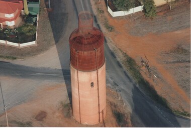 Rutherglen Historical Society
Photograph - Aerial Images, c2000
... Colour aerial photograph of the old Rutherglen water tower... on top to make it look like a wine bottle. Photograph Aerial ...The Rutherglen 'Big Wine Bottle', once a water tower to supply the town's water, is now kept as a tourist attraction.Colour aerial photograph of the old Rutherglen water tower with the structure on top to make it look like a wine bottle.water tower, water supply, rutherglen winebottle -
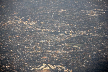 Ballarat Heritage Services
Digital photographs, L.J. Gervasoni, Kew from the Air, c2014
... Colour aerial photograph of the Melbourne Suburb of Kew... aerial Colour aerial photograph of the Melbourne Suburb of Kew ...Colour aerial photograph of the Melbourne Suburb of Kew taken from an aeroplane coming into land at Tullamarine Airport, Melbourne. melbourne, kew, hawthorn, camberwell, landscape, aerial -
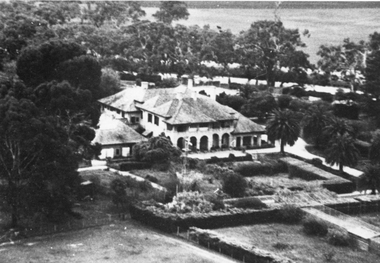 Stawell Historical Society Inc
Photograph, “Warranooke” Homestead in Glenorchy 1867 -- aerial view
... Black and white aerial photograph of building showing...” Homestead in Glenorchy 1867 -- aerial view Photograph ...Aerial View of “Warranooke” Homestead. “Warranooke” Homestead built 1867 enlarged 1926. Shows extensive gardens at front. A very early property in our district Warranooke The main names associated with the property Ayrey - Darnell - Nicoll, later Campbell. Mrs. Campbell built Charles Ayrey's daughter. The Campbells built up the station buildings. The homestead was virtually rebuilt in brick, making it one of the largest and most elaborate in the East Wimmera. Warranooke homestead built 1867, enlarged 1926 destroyed by fire 13th Feb. 1979.Black and white aerial photograph of building showing landscape around the homestead. The photo is on a card with some gold decorations.glenorchy -
 Stawell Historical Society Inc
Photograph - Slides, Ian McCann, Aerial View 1976, 1976 - 1984
... Aerial Colour Photograph of Stawell... grampians Aerial Colour Photograph of Stawell Aerial View 1976 ...Aerial Colour Photograph of Stawell -
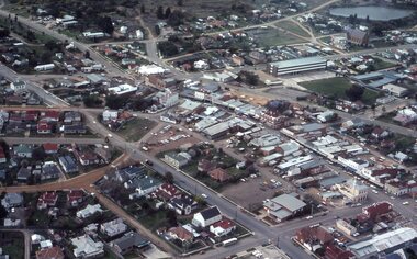
 Phillip Island and District Historical Society Inc.
Photograph, c. 1959
... Aerial photograph of the intersection of Thompson Avenue... West Aerial photograph of the intersection of Thompson Avenue ...One of a collection of over 400 photographs in an album commenced in 1960 and presented to the Phillip Island & Westernport Historical Society by the Shire of Phillip IslandAerial photograph of the intersection of Thompson Avenue & Chapel Street showing General Store, Phillip Island Garage and Catholic Church.local history, photography, intersection thompson avenue & chapel street, cowes, black & white photograph, thompson avenue cowes, chapel street cowes, garages, churches, john jenner, bryant west -
Tatura Irrigation & Wartime Camps Museum
Book, Hill Top Golf & Country Club, 1985
... Soft cover - pale green with black and white aerial.... 26.6.85 Soft cover - pale green with black and white aerial ...History of formation of Hill Top Golf and Country Club and Bowls ClubSoft cover - pale green with black and white aerial photograph of Hill Top across middle and Hill Top logo.Presented to Tatura and District by J Forster. 26.6.85hill top golf and country club, hill top bowls club -
Whitehorse Historical Society Inc.
Map, Springvale Road, 1987
... Aerial photograph of cnr Springvale Road and Burwood... Mitcham melbourne Aerial photographs Blackburn Road Burwood East ...Aerial photograph of cnr Springvale Road and Burwood Highway, south past Highbury Road and west past Blackburn Road.Aerial photograph of cnr Springvale Road and Burwood Highway, south past Highbury Road and west past Blackburn Road.Aerial photograph of cnr Springvale Road and Burwood Highway, south past Highbury Road and west past Blackburn Road.aerial photographs, blackburn road, burwood east, highbury road, burwood east, burwood highway, burwood east, springvale road, burwood east, burwood east -
 Kew Historical Society Inc
Photograph - Aerial View of East Kew, c.1930
... Framed aerial photograph of that part of Kew in which... aerial photograph of Kew genazzano fcj kew reservoir rimington's ...The Municipality of Kew was proclaimed in 1860. This eastern section of Kew was settled from the 1850s with all land sold in the vicinity by 1851. The original large estates were further subdivided in the second half of the 19th and in the first decades of the 20th centuries.Early aerial photograph of KewFramed aerial photograph of that part of Kew in which is located Genazzano FCJ, the Kew Reservoir, and the retail nurseries of Bennett’s and Rimington's.genazzano fcj, kew reservoir, rimington's nurseries, bennett's nursery, cotham road, mont victor road (kew) -
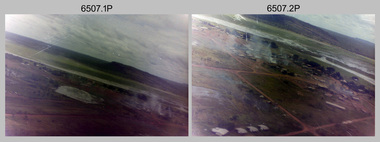 Bendigo Military Museum
Photograph - 4th Field Survey Squadron – Operation NERVOSE 85 Field Phase Oblique Photos, NT, 1985
... This is a set of 20 oblique aerial photographs taken during...This is a set of 20 oblique aerial photographs taken during...This is a set of 20 oblique aerial photographs taken during ...This is a set of 20 oblique aerial photographs taken during the field phase of 4th Field Survey Squadron’s Operation NERVOSE 85 project in the Northern Territory in 1985. Operation NERVOSE 85 was mounted by 4 Fd Svy Sqn in the EAST ARNHEM, VICTORIA RIVER DOWNS AND DALY WATERS areas of the Northern Territory from 26 May to 18 Sep 85. The aim of Operation NERVOSE 85 was to finalise the horizontal and vertical control for mapping at a scale of 1:50,000, to field check 40x 1:50,000 preliminary maps and to obtain mapping photography in support of the RAAF TINDAL redevelopment project. *Note –These photos were most likely taken in 1985, contrary to the ‘1987’ date annotated on the negative sleeves. The Op NERVOSE 85 Project Report available on RASVY’s web site lists a nominal roll of personnel. Photos of 4 Fd Svy Sqn taken in 1985 and 1987 provide names of posted personnel. Several personnel identified in these photos were posted to 4 Fd Svy Sqn in 1985, not in 1987. See items 6504.13P, 6505.28P and 6506.16P for more photos taken prior to and during Operation NERVOSE 1985. This is a set of 20 oblique aerial photographs taken during the field phase of 4th Field Survey Squadron’s Operation NERVOSE 85 project in the Northern Territory in 1985. The colour photographs on 35mm negative film and are part of the Army Survey Regiment’s Collection. The photographs were scanned at 96 dpi. .1) to .20) - Photo, colour, 1985. Unknown locations..1P to .20P – There are no personnel identified. ‘1987 OP NERVOSE VICTORIA RIVER DOWNS AND DALY WATERS.’ annotated on negative sleeve.royal australian survey corps, rasvy, 4 fd svy sqn, op nervose 85 -
 Phillip Island and District Historical Society Inc.
Photograph, 1960
... Aerial photograph of the Cowes Kindergarten in Chapel... Aerial photograph of the Cowes Kindergarten in Chapel Street ...One of a collection of over 400 photographs in an album commenced in 1960 and presented to the Phillip Island & Westernport Historical Society by the Shire of Phillip IslandAerial photograph of the Cowes Kindergarten in Chapel Street, Cowes. Now next to the Cowes State School in Settlement Road. (JG 2017)local history, photography, cowes kindergarten, black & white photograph, kindergartens, chapel street cowes, john jenner, bryant west -
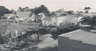
Glenelg Shire Council Cultural Collection
Photograph - Photograph - Portland Harbour, 1958
... Black & white aerial photograph of Portland Harbour, also... aerial photograph of Portland Harbour, also showing foreshore ...Port of Portland Authority ArchivesBack: "L - R" - top left pencil. Purple Stamp - TOP RIGHT "17 Nov 1958"port of portland archives, portland harbour, bentinck street, all saints, foreshore, 1958 -
Glenelg Shire Council Cultural Collection
Photograph - Photograph -K.S Anderson Wharf, n.d
... Black and white aerial photograph showing a sheep ship... and white aerial photograph showing a sheep ship berthed at the K.S ...Port of Portland Authorityport of portland archives, k s anderson wharf -
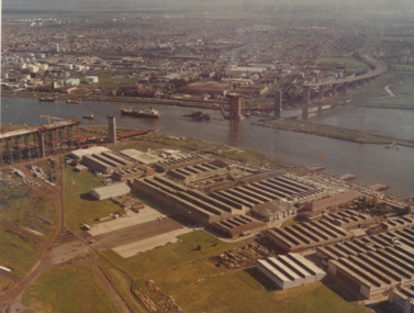 Port Melbourne Historical & Preservation Society
Photograph - Aerial view of West Gate Bridge under construction, 1960 - 1979
... Colour aerial photograph of West Gate Bridge under... on top right corner and on back Colour aerial photograph of West ...Colour aerial photograph of West Gate Bridge under construction. Fishermans Bend factories in foreground. Ship in the river and view to Williamstown"Master copy. Not to be removed from marketing Department" stamped on top right corner and on backtransport, engineering, engineering - bridges, fishermans bend, industry, west gate bridge, rotten row, williamstown, yarra river -
Port Melbourne Historical & Preservation Society
Photograph - Aerial view of Port Melbourne, 1931
... Section of aerial photograph of Port Melbourne c1931 (refer... Sandridge Lagoon Built Environment Section of aerial photograph ...Section of aerial photograph of Port Melbourne c1931 (refer item 574), covering Beach to Spring Street and Lagoon to Lyons Streetsandridge lagoon, built environment -
National Vietnam Veterans Museum (NVVM)
Document, The First Australian Field Hospital
... Framed Document featuring an Aerial Photograph... an Aerial Photograph of the hospital compound with buildings ...Framed Document featuring an Aerial Photograph of the hospital compound with buildings. Identified photograph is surrounded by the history of the hospitals, admission and service statistics.Variousframed document, first australian field hospital, vung tau -
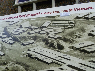 National Vietnam Veterans Museum (NVVM)
Photograph, 1 Aust FD Hospital Vung Tau South Vietnam
... Aerial photograph wall panel of 1 Aust Field Hospital Vung... Hospital 1 Australian Field Hospital Vung Tau South Vietnam Aerial ...Aerial photograph wall panel of 1 Aust Field Hospital Vung Tau, features layout and labelled building of hospital complex1 Australian Field Hospital Vung Tau South Vietnam1st australian field hospital -
Whitehorse Historical Society Inc.
Map, Campbell's Croft, c1970
... Enlarged aerial photograph of the area around Campbell's... Court Vermont Aerial photographs Enlarged aerial photograph ...Enlarged aerial photograph of the area around Campbell's Croft Reserve. State aerial Survey, Melbourne, 1970 project. Run 37Enlarged aerial photograph of the area around Campbell's Croft Reserve. State aerial Survey, Melbourne, 1970 project. Run 37Enlarged aerial photograph of the area around Campbell's Croft Reserve. State aerial Survey, Melbourne, 1970 project. Run 37campbells croft, boronia road, vermont, madonna court, vermont, aerial photographs -
Whitehorse Historical Society Inc.
Map, Springvale Road, 1981
... Aerial photograph of area including cnr. Springvale Road... Mitcham melbourne Aerial photographs Burwood East Springvale Road ...Aerial photograph of area including cnr. Springvale Road and Burwood Highway, south past Highbury Road and west to Sevenoaks Road.Aerial photograph of area including cnr. Springvale Road and Burwood Highway, south past Highbury Road and west to Sevenoaks Road.Aerial photograph of area including cnr. Springvale Road and Burwood Highway, south past Highbury Road and west to Sevenoaks Road.aerial photographs, burwood east, springvale road, burwood east, burwood highway, burwood east, sevenoaks road, burwood east, highbury road, burwood east -
Whitehorse Historical Society Inc.
Map, Springvale Road, 1975
... Aerial photograph of area around cnr. of Springvale Road... Mitcham melbourne Aerial photographs Vermont South Highbury Road ...Aerial photograph of area around cnr. of Springvale Road and Burwood Highway, south past Highbury Road and East in Vermont South.Aerial photograph of area around cnr. of Springvale Road and Burwood Highway, south past Highbury Road and East in Vermont South.Aerial photograph of area around cnr. of Springvale Road and Burwood Highway, south past Highbury Road and East in Vermont South.aerial photographs, vermont south, highbury road, burwood east, burwood highway, burwood east, burwood east -
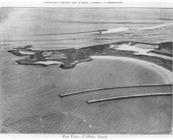 Port Fairy Historical Society Museum and Archives
Photograph, C. 1925
... Black and white aerial photograph of Griffith island... Fairyb Harbour 1925" Black and white aerial photograph ...Black and white arial photograph of the Moyne river entrance, the original signed by R.W.Golding.Black and white aerial photograph of Griffith island showing the lighthouse keeper’s compound, the large flagstaff and the river training walls in the foregroundHand written on the back "Port Fairy Moyne River Entrance R. W. Golding Handwritten on the back of the copy "Port Fairyb Harbour 1925"local history, photography, photographs, slides, film, arial, moyne river