Showing 667 items matching "auctioneer"
-
 Kew Historical Society Inc
Plan - Subdivision Plan, Six Big Home Sites, Camberwell North, c.1936
Subdivision plans are historically important documents used as evidence of the growth of suburbs in Australia. They frequently provide information about when the land was sold on which a built structure was subsequently constructed as well as evidence relating to surveyors and real estate and financial agents. The numerous subdivision plans in the Kew Historical Society's collection represent working documents, ranging from the initial sketches made in planning a subdivision to printed plans on which auctioneers or agents listed the prices for which individual lots were sold. In a number of cases, the reverse of a subdivision plan in the collection includes a photograph of a house that was also for sale by the agent. These photographs provide significant heritage information relating house design and decoration, fencing and household gardens.A subdivision in what is currently Balwyn, but which was advertised as being in Camberwell North. The subdivision included six allotments facing Buchanan Avenue and Houghton Street. The subdivision was to the east of the Pointed Firs Estate (1936). In addition to the intrinsic value of this subdivision plan, it also reveals information about the development of transport infrastructure in this area. The subdivision plan notes that the Tramways Board has approved the extension of the tram route past the current terminus at Balwyn Road.subdivision plans - camberwell -
 Kew Historical Society Inc
Plan - Subdivision Plan, Glenferrie Road & Wellington St, Kew, c.1920s
Subdivision plans are historically important documents used as evidence of the growth of suburbs in Australia. They frequently provide information about when the land was sold on which a built structure was subsequently constructed as well as evidence relating to surveyors and real estate and financial agents. The numerous subdivision plans in the Kew Historical Society's collection represent working documents, ranging from the initial sketches made in planning a subdivision to printed plans on which auctioneers or agents listed the prices for which individual lots were sold. In a number of cases, the reverse of a subdivision plan in the collection includes a photograph of a house that was also for sale by the agent. These photographs provide significant heritage information relating house design and decoration, fencing and household gardens.An unnamed subdivision in Kew including eleven lots for sale bordering Glenferrie Road, Wellington Street and Franks Grove.subdivision plans - kew, franks grove, wellington street, glenferrie road -
 Kew Historical Society Inc
Plan - Subdivision Plan, Windella-Darnley Subdivision, Studley Park, 1920s
Subdivision plans are historically important documents used as evidence of the growth of suburbs in Australia. They frequently provide information about when the land was sold on which a built structure was subsequently constructed as well as evidence relating to surveyors and real estate and financial agents. The numerous subdivision plans in the Kew Historical Society's collection represent working documents, ranging from the initial sketches made in planning a subdivision to printed plans on which auctioneers or agents listed the prices for which individual lots were sold. In a number of cases, the reverse of a subdivision plan in the collection includes a photograph of a house that was also for sale by the agent. These photographs provide significant heritage information relating house design and decoration, fencing and household gardens.Version 1 of two subdivision plans (the later one is MAP.0027) for the section of Studley Park Road near the Junction on the south side. Named in the subdivision are the mansions of Darley and Windella (now demolished). Before the subdivision of Darley and Windella, both houses fronted Studley Park Road. Both houses appear to be advertised as lots in the subdivision. Bisecting the subdivision is a street, Antrim Avenue that was never constructed. A street, which was subsequently constructed in this vicinity, was Merrion Place, which now runs between Studley Park Road and Highfield Grove. There are 14 proposed lots in this subdivision."Antrim Avenue. See over for new plan"subdivision plans - kew, studley park, windella, darnley, studley park road -- kew (vic.), merrion place -- kew (vic.), merrion grove -- kew (vic.), highbury grove -- kew (vic.) -
 Kew Historical Society Inc
Plan - Subdivision Plan, Windella-Darnley Subdivision, Studley Park, 1920s
Subdivision plans are historically important documents used as evidence of the growth of suburbs in Australia. They frequently provide information about when the land was sold on which a built structure was subsequently constructed as well as evidence relating to surveyors and real estate and financial agents. The numerous subdivision plans in the Kew Historical Society's collection represent working documents, ranging from the initial sketches made in planning a subdivision to printed plans on which auctioneers or agents listed the prices for which individual lots were sold. In a number of cases, the reverse of a subdivision plan in the collection includes a photograph of a house that was also for sale by the agent. These photographs provide significant heritage information relating house design and decoration, fencing and household gardens.Version 2 of two subdivision plans (the earlier is 2016.0305.1) for the section of Studley Park Road near the Junction on the south side. Named in the subdivision are the mansions of Darley and Windella (now demolished). Before the subdivision of Darley and Windella, both houses fronted Studley Park Road. Both houses appear to be advertised as lots in the subdivision. Bisecting the subdivision is a street, Antrim Avenue that was never constructed. A street, which was subsequently constructed in this vicinity, was Merrion Place, which now runs between Studley Park Road and Highfield Grove. There are 13 proposed lots in this subdivision in contrast to the earlier plan. This resulted from larger lots being proposed for Studley Park Road.subdivision plans - kew, studley park, windella, darnley, antrim avenue -- kew (vic.), studley park road -- kew (vic.), merrion place -- kew (vic.), merrion grove -- kew (vic.), highbury grove -- kew (vic.) -
 Kew Historical Society Inc
Plan - Subdivision Plan, Shop Sites, East Kew, c.1927
Subdivision plans are historically important documents used as evidence of the growth of suburbs in Australia. They frequently provide information about when the land was sold on which a built structure was subsequently constructed as well as evidence relating to surveyors and real estate and financial agents. The numerous subdivision plans in the Kew Historical Society's collection represent working documents, ranging from the initial sketches made in planning a subdivision to printed plans on which auctioneers or agents listed the prices for which individual lots were sold. In a number of cases, the reverse of a subdivision plan in the collection includes a photograph of a house that was also for sale by the agent. These photographs provide significant heritage information relating house design and decoration, fencing and household gardens.This is one of a small number of subdivision plans for commercial property in the collection. The subdivision proposed to create six shop sites in High Street between the Harp of Erin and Station Street. The plan shows this stretch of High Street, East Kew already lined with shops that include the hotel on the corner, the new State Savings Bank, a dentist’s surgery and Lambert’s Store. The High Street Tram was to reach Burke Road in 1925, so the proposed subdivision must postdate that event, and the opening of the Bank in 1926.subdivision plans - east kew, high street - east kew -
 Kew Historical Society Inc
Plan - Subdivision Plan, Eastlawn Estate, 1914
Subdivision plans are historically important documents used as evidence of the growth of suburbs in Australia. They frequently provide information about when the land was sold on which a built structure was subsequently constructed as well as evidence relating to surveyors and real estate and financial agents. The numerous subdivision plans in the Kew Historical Society's collection represent working documents, ranging from the initial sketches made in planning a subdivision to printed plans on which auctioneers or agents listed the prices for which individual lots were sold. In a number of cases, the reverse of a subdivision plan in the collection includes a photograph of a house that was also for sale by the agent. These photographs provide significant heritage information relating house design and decoration, fencing and household gardens.The ‘Eastlawn Estate’ was surveyed and ready for auction in March 1914, three months before the outbreak of World War I. Sixty-six allotments, created on the ‘order of Mr & Miss Preston’ surrounded the mansion of Woodlands in Harp Road. Woodlands formed part of the Estate, being advertised as lot 1. The allotments faced High, Station and Wright Streets, Harp and Normanby Roads, and Woodlands Avenue. Pru Sanderson in the Kew Conservation Study (Vol.2, 1988) wrote that the Eastlawn Estate ‘covered the western half of the failed Harp of Erin Estate’. Contemporary advertisements promoted the Eastlawn Estate as: ‘There will be no more convenient district nor pleasant Suburb than East Kew for the busy business man. When the Electric Tram is laid, he will be able to journey quickly and pleasantly direct from Collins Street to his home in the Eastlawn Estate in about 20 minutes’. The actual plans of subdivision were included in advertisements in The Argus and in the local newspapers.subdivision plans - east kew, eastlawn estate -
 Kew Historical Society Inc
Plan - Subdivision Plan, Raheen Estate Subdivision, 1960
Subdivision plans are historically important documents used as evidence of the growth of suburbs in Australia. They frequently provide information about when the land was sold on which a built structure was subsequently constructed as well as evidence relating to surveyors and real estate and financial agents. The numerous subdivision plans in the Kew Historical Society's collection represent working documents, ranging from the initial sketches made in planning a subdivision to printed plans on which auctioneers or agents listed the prices for which individual lots were sold. In a number of cases, the reverse of a subdivision plan in the collection includes a photograph of a house that was also for sale by the agent. These photographs provide significant heritage information relating house design and decoration, fencing and household gardens.The Raheen Estate Subdivision of 1960 involved the creation of 36 residential allotments and the sale of 34 of these. The land on which the subdivision was created had until 1960 formed part of the grounds of the mansion Raheen in Studley Park Road. In 1917, the Catholic Church had purchased Raheen and its lands. It was to become the home of Archbishop of Melbourne, Daniel Mannix, for 46 years. The sale of the subdivision took place three years before the Archbishop’s death. Subsequent archbishops were to reside at Raheen until its sale to the Pratt family in 1981. When the sale of the Estate was reported in the newspapers in 1960, it was described as the last big subdivision near Melbourne. At the auction, 33 of the 36 allotments were sold. The auction realised £315,750. Purchasers were advised that the vendor intended to keep lots 22 and 23. The alllotments in the subdivision required the construction of new roads. These included Eamon Court and Raheen Drive. The justification provided by the Church for the sale was that the estate was being sold to finance school building projects.subdivision plans - kew, studley park, raheen estate, eamon court, studley park road, coombes avenue, raheen drive -
 Kew Historical Society Inc
Plan - Subdivision Plan, Oswinia Estate, East Kew, c.1925
Prue Sanderson, in her groundbreaking ‘City of Kew Urban Conservation Study : Volume 2 - Development History’ (1988), summarised the periods of urban development and subdivisions of land in Kew. The periods that she identified included 1845-1880, 1880-1893, 1893-1921, 1921-1933, 1933-1943, and Post-War Development. These periods were selected as they represented periods of rapid growth or decline in urban development. An obvious starting point for Sanderson’s groupings involved population growth and the associated economic cycles. These cycles also highlighted urban expansion onto land that was predominantly rural, although in other cases it represented the decline and breakup of large estates. A number of the plans in the Kew Historical Society’s collection can also be found in other collections, such as those of the State Library of Victoria and the Boroondara Library Service. A number are however unique to the collection.Subdivision plans are historically important documents used as evidence of the growth of suburbs in Australia. They frequently provide information about when the land was sold on which a built structure was subsequently constructed as well as evidence relating to surveyors and real estate and financial agents. The numerous subdivision plans in the Kew Historical Society's collection represent working documents, ranging from the initial sketches made in planning a subdivision to printed plans on which auctioneers or agents listed the prices for which individual lots were sold. In a number of cases, the reverse of a subdivision plan in the collection includes a photograph of a house that was also for sale by the agent. These photographs provide significant heritage information relating house design and decoration, fencing and household gardens.The ‘Oswinia Estate’ subdivision in East Kew was planned and auctioned in the first half of the 1920s. 169 allotments were created in the triangular section of land bordered by High Street, Burke Road and the Government Boulevard (later Kilby Road). The only piece of land excluded was that where the previous Kew Pound had been located at the east tip of the triangle. Allotments were created fronting Glass, High, Namur, Oswin Streets, Irymple Avenue, and the Government Boulevard. The name for the Estate was derived from Oswin’s farm, which had been one of the largest landholdings in East Kew. The selling agents annotated the plan in our collection with crosses indicating those lots that had been sold. The inset locality plan is particularly interesting as it shows the route and stations of the Outer Circle Railway. When the subdivision plan was created, it included the proposed bridge over the Yarra at Burke Road. The bridge was to be officially opened in 1926.subdivision plans - east kew, oswinia estate, high street, glass street, namur street, government boulevard - kilby road, irymple street, oswin street -
 Kew Historical Society Inc
Plan - Subdivision Plan, 6 Choice Residential Allotments: East Kew, 1932
Prue Sanderson, in her groundbreaking ‘City of Kew Urban Conservation Study : Volume 2 - Development History’ (1988), summarised the periods of urban development and subdivisions of land in Kew. The periods that she identified included 1845-1880, 1880-1893, 1893-1921, 1921-1933, 1933-1943, and Post-War Development. These periods were selected as they represented periods of rapid growth or decline in urban development. An obvious starting point for Sanderson’s groupings involved population growth and the associated economic cycles. These cycles also highlighted urban expansion onto land that was predominantly rural, although in other cases it represented the decline and breakup of large estates. A number of the plans in the Kew Historical Society’s collection can also be found in other collections, such as those of the State Library of Victoria and the Boroondara Library Service. A number are however unique to the collection.Subdivision plans are historically important documents used as evidence of the growth of suburbs in Australia. They frequently provide information about when the land was sold on which a built structure was subsequently constructed as well as evidence relating to surveyors and real estate and financial agents. The numerous subdivision plans in the Kew Historical Society's collection represent working documents, ranging from the initial sketches made in planning a subdivision to printed plans on which auctioneers or agents listed the prices for which individual lots were sold. In a number of cases, the reverse of a subdivision plan in the collection includes a photograph of a house that was also for sale by the agent. These photographs provide significant heritage information relating house design and decoration, fencing and household gardens.The mansion Woodlands in Harp Road, East Kew suffered the death of a thousand cuts. In its case, the cuts were subdivisions. Previous subdivisions of the mansion and its grounds were given titles such as ‘The Eastlawn Estate’ (MAP.0055), whereas at the end, the subdivision called it as it was, naming itself the ‘final section of the Woodlands Estate’ when it was put up for auction in 1932. The emphasis in the promotion of the subdivision was that it provided purchasers with splendid opportunities ‘to build modern homes in select, well established modern surroundings’. As with other subdivisions in the interwar period, transport links were emphasised. The six residential lots cut Woodlands off from Harp Road. When the vendor, Louisa Rachel Preston Hill, was to die at Woodlands in 1937 aged 86 her address was given as Normanby Road.subdivision plans - kew, woodlands estate -
 Kew Historical Society Inc
Plan - Subdivision Plan, Plan of Subdivision of Crown Portion 71, Parish of Boroondara LP12509, Vol.1678, Fol.335526, Before 1930
Prue Sanderson, in her groundbreaking ‘City of Kew Urban Conservation Study : Volume 2 - Development History’ (1988), summarised the periods of urban development and subdivisions of land in Kew. The periods that she identified included 1845-1880, 1880-1893, 1893-1921, 1921-1933, 1933-1943, and Post-War Development. These periods were selected as they represented periods of rapid growth or decline in urban development. An obvious starting point for Sanderson’s groupings involved population growth and the associated economic cycles. These cycles also highlighted urban expansion onto land that was predominantly rural, although in other cases it represented the decline and breakup of large estates. A number of the plans in the Kew Historical Society’s collection can also be found in other collections, such as those of the State Library of Victoria and the Boroondara Library Service. A number are however unique to the collection.Subdivision plans are historically important documents used as evidence of the growth of suburbs in Australia. They frequently provide information about when the land was sold on which a built structure was subsequently constructed as well as evidence relating to surveyors and real estate and financial agents. The numerous subdivision plans in the Kew Historical Society's collection represent working documents, ranging from the initial sketches made in planning a subdivision to printed plans on which auctioneers or agents listed the prices for which individual lots were sold. In a number of cases, the reverse of a subdivision plan in the collection includes a photograph of a house that was also for sale by the agent. These photographs provide significant heritage information relating house design and decoration, fencing and household gardens.The six lots on the south side of Macartney Avenue, between Macartney Avenue and Daniell Place were part of a subdivision that occurred before 1930. The subdivision plan is of interest in that the original name of Daniell Place was Brougham Place. On the Plan, it is noted that lots 5 and 6 (currently 10 and 12 Macartney Avenue) had been sold for £13 each. By November 1930, the new six-roomed villa built on 12 Macartney Avenue was offered for immediate sale at a ‘sacrifice price’. Any offer in reason would be considered, although a £350 deposit was required.subdivision plans - kew, mount street - kew, brougham street - kew , macartney avenue - kew -
 Kew Historical Society Inc
Plan - Subdivision Plan, Tregarron Estate, Kew, c.1929
Pru Sanderson, in her groundbreaking ‘City of Kew Urban Conservation Study : Volume 2 - Development History’ (1988), summarised the periods of urban development and subdivisions of land in Kew. The periods that she identified included 1845-1880, 1880-1893, 1893-1921, 1921-1933, 1933-1943, and Post-War Development. These periods were selected as they represented periods of rapid growth or decline in urban development. An obvious starting point for Sanderson’s groupings involved population growth and the associated economic cycles. These cycles also highlighted urban expansion onto land that was predominantly rural, although in other cases it represented the decline and breakup of large estates. A number of the plans in the Kew Historical Society’s collection can also be found in other collections, such as those of the State Library of Victoria and the Boroondara Library Service. A number are however unique to the collection.Subdivision plans are historically important documents used as evidence of the growth of suburbs in Australia. They frequently provide information about when the land was sold on which a built structure was subsequently constructed as well as evidence relating to surveyors and real estate and financial agents. The numerous subdivision plans in the Kew Historical Society's collection represent working documents, ranging from the initial sketches made in planning a subdivision to printed plans on which auctioneers or agents listed the prices for which individual lots were sold. In a number of cases, the reverse of a subdivision plan in the collection includes a photograph of a house that was also for sale by the agent. These photographs provide significant heritage information relating house design and decoration, fencing and household gardens.In January 1929, the Kew City Council called for tenders to construct Tregarron Avenue. The subdivision of the Tregarron Estate in Kew was for 11 lots bordering Tregarron Avenue and its entrance from Burke Road. The plan includes annotations that indicate the measurement of each block and the placement of the drainage and sewerage easements. This plan is interesting for a number of factors. The house blocks today have different street numbers, some blocks were to be further subdivided, and at the time of the subdivision, alterations were still being made to the extent of lots offered; lots 2 and 3 on the plan were subdivided and reoriented.subdivision plans - kew, tregarron estate, tregarron avenue -- kew (vic.), burke road -- kew (vic.) -
 Kew Historical Society Inc
Plan - Subdivision Plan, St Helliers Estate, Kew, circa 1910, c.1910
Pru Sanderson, in her groundbreaking ‘City of Kew Urban Conservation Study : Volume 2 - Development History’ (1988), summarised the periods of urban development and subdivisions of land in Kew. The periods that she identified included 1845-1880, 1880-1893, 1893-1921, 1921-1933, 1933-1943, and Post-War Development. These periods were selected as they represented periods of rapid growth or decline in urban development. An obvious starting point for Sanderson’s groupings involved population growth and the associated economic cycles. These cycles also highlighted urban expansion onto land that was predominantly rural, although in other cases it represented the decline and breakup of large estates. A number of the plans in the Kew Historical Society’s collection can also be found in other collections, such as those of the State Library of Victoria and the Boroondara Library Service. A number are however unique to the collection.Subdivision plans are historically important documents used as evidence of the growth of suburbs in Australia. They frequently provide information about when the land was sold on which a built structure was subsequently constructed as well as evidence relating to surveyors and real estate and financial agents. The numerous subdivision plans in the Kew Historical Society's collection represent working documents, ranging from the initial sketches made in planning a subdivision to printed plans on which auctioneers or agents listed the prices for which individual lots were sold. In a number of cases, the reverse of a subdivision plan in the collection includes a photograph of a house that was also for sale by the agent. These photographs provide significant heritage information relating house design and decoration, fencing and household gardens.In the subdivision of part of Crown Portion 82, bordered by John and Sackville Streets and Cotham and Burke Roads, over 100 lots were offered for sale. In addition to the designated lots, a number of key locations are also identified. These include the Genazzano Convent to the north of Cotham Road, the Reservoir, St Hilary’s and the land holding of Colonel Parnell on the corner of John Street and Cotham Road. On the Plan, No. 5064, is the handwritten name ‘St. Hellier’s Estate’. St. Helliers, the home of the Dumaresq family is shown beside St. Hilary’s.subdivision plans - kew, st helliers estate -
 Kew Historical Society Inc
Plan - Subdivision Plan, Jas R Mathers Son & McMillan, Macartney Estate, East Kew, c. 1925
Pru Sanderson, in her groundbreaking ‘City of Kew Urban Conservation Study : Volume 2 - Development History’ (1988), summarised the periods of urban development and subdivisions of land in Kew. The periods that she identified included 1845-1880, 1880-1893, 1893-1921, 1921-1933, 1933-1943, and Post-War Development. These periods were selected as they represented periods of rapid growth or decline in urban development. An obvious starting point for Sanderson’s groupings involved population growth and the associated economic cycles. These cycles also highlighted urban expansion onto land that was predominantly rural, although in other cases it represented the decline and breakup of large estates. A number of the plans in the Kew Historical Society’s collection can also be found in other collections, such as those of the State Library of Victoria and the Boroondara Library Service. A number are however unique to the collection.Subdivision plans are historically important documents used as evidence of the growth of suburbs in Australia. They frequently provide information about when the land was sold on which a built structure was subsequently constructed as well as evidence relating to surveyors and real estate and financial agents. The numerous subdivision plans in the Kew Historical Society's collection represent working documents, ranging from the initial sketches made in planning a subdivision to printed plans on which auctioneers or agents listed the prices for which individual lots were sold. In a number of cases, the reverse of a subdivision plan in the collection includes a photograph of a house that was also for sale by the agent. These photographs provide significant heritage information relating house design and decoration, fencing and household gardens.The Macartney Estate subdivision advertised 21 lots for sale on either side of Macartney Street (now Macartney Avenue) and Evans Road in what was then designated as East Kew. Most of the houses shown on the south side of Macartney Street then, as now, have rear entrances on Mount Street, however a number of these blocks have since been further subdivided to allow for the building of new houses on the rear of a block. Brougham Place is marked on the plan but is now called Daniell Place."C"subdivision plans - east kew, macartney estate, macartney street, mount street, evans road, brougham place -
 RMIT GSBL Justice Smith Collection
Book, Dean, Arthur, The law relating to estate agents and auctioneers : being a concise statement of the law governing the rights, duties and liabilities of auctioneers, estate agents, business agents and farm produce agents and the functions ordinarily performed by them, 1941
Previous owners: T. H. Smith, T. W. SmithSecond editionreal estate business -- law and legislation -- victoria, vendors and purchasers -- victoria, agency (law) -- victoria -
Stawell Historical Society Inc
Archive, Larkan Bros Auctioneers 1934 – 1958, 1934 - 1958
Ledger, Quarter Leather Boundstawell, business -
 City of Greater Bendigo - Civic Collection
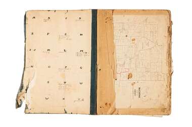
Administrative record - Land Sales, A. J. Mullet Government Printer et al, 1927
This type of album was made by agents auctioning and selling land.Large portfolio style album with dark green / black cloth cover bound with three large metal pins. Forty eight pages with twenty seven Department of Lands and Survey maps and newspaper clippings about land sales and auction details pasted in. Index page. Maps have handwritten notes and markings throughout in pencil and pen. Covers the County's of Gunbower and Tatchera. Includes a receipt slip with hand written notes on reverse on William Wallace & Co letterhead. city of bendigo commerce -
 City of Greater Bendigo - Civic Collection
Administrative record - Land Sales, Department of Lands and Survey et al, 1929
This type of album was created by agents auctioning and selling land.Large portfolio style album with green cloth cover bound with three large metal pins. One hundred and then pages with thirty three Department of Lands and Survey maps pasted in. Index page. Maps have handwritten notes and markings throughout in pencil and pen. Covers the Counties of Bendigo, Rodney, Talbot, Gunbower, Gladstone, Tatchera and Karkarooc, Shires of East Loddon and Huntly and Swan Hill District. -
Canterbury History Group
Pamphlet - Ye Heights of Canterburie; Ye Star of the Eastern Suburbs, 1887
Photocopy of brochure advertising sale by auction of ' 70 Business and Villa sites' in Canterbury on 10 December 1887.Includes map of the allotments.canterbury, canterbury road, church street, highfield road, margaret street, land subdivision, flint> f.l, auctioneers -
Canterbury History Group
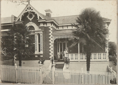
Pamphlet - Range Estate, Canterbury, 1/04/1916 12:00:00 AM
Photocopy of a Coghill & Haughton brochure advertising the sale by auction of '19 superb Villa and Mansion' sites in Canterbury on 15 April 1916. Includes map of the allotments and photographs of five existing homes on the estate.canterbury, balwyn road, hopetoun avenue, mont albert road, view street, coghill & haughton, land sales, grange estate, auctioneers -
 Bacchus Marsh & District Historical Society
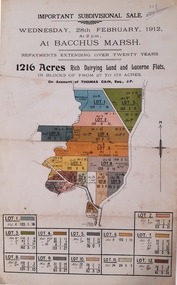
Map, Important Subdivisional Sale at Bacchus Marsh, Wednesday 28 February, 1912, 1912
In the later 19th century and early 20th centuries Thomas Cain was a major farmer in the Bacchus Marsh district and a significant participant in community life and affairs. The sale of some of his most significant properties towards the end of his life generated wide interest in Bacchus Marsh and beyond.Paper. 33cm x 21cmnon-fictionIn the later 19th century and early 20th centuries Thomas Cain was a major farmer in the Bacchus Marsh district and a significant participant in community life and affairs. The sale of some of his most significant properties towards the end of his life generated wide interest in Bacchus Marsh and beyond.land sales, thomas cain, landholders -
 Bendigo Historical Society Inc.
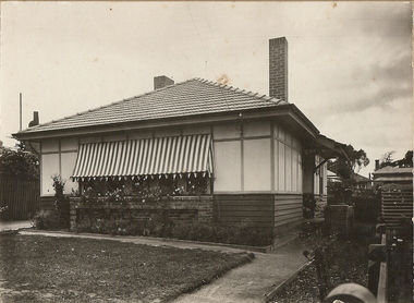
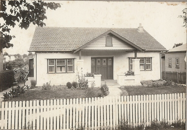
Photograph - T C WATTS & SON COLLECTION: 44 HONEYSUCKLE STREET, BENDIGO, 930
John Robinson (1897-1947) married Mary Maloney (1893-1978) in 1927. John was a bank teller and when he died in Ballarat he was described as a bank manager.Black and white photographs (2) mounted on rectangular brown board. House, weatherboard and cement sheet, brick flower box under front window. 2 chimneys, tiled roof,canopy over door at side, striped sun blind with scallops over window. On back of photo: 'Mr. Robinson, 44 Honeysuckle Street, £1100 sewered'Frank A. Jeffree, Bendigoplace, building, residential, stamped on back in rectangle ''t.c. watts and son/auctioneer/estate agents/253 mitchell street/bendigo'' stamped on back in circle ''royal historical society of victoria, bendigo branch'' -
 Bendigo Historical Society Inc.
Photograph - T C WATTS & SON COLLECTION: 20 BANCROFT STREET, 1930
BHS CollectionBlack and white photograph mounted on rectangular grey board. House, brick, corrugated iron roof, bullnose verandah, shutters on end window, creeper on verandah posts, 'fan' in fill to gable, scalloped picket fence, telephone pole outside corner of block. 20 Bancroft Street.Frank A. Jeffree, Bendigoplace, building, residential, stamped on back in rectangle ''t.c. watts and son/auctioneer/estate agents/253 mitchell street/bendigo'' stamped on back in circle ''royal historical society of victoria, bendigo branch'' -
Glen Eira Historical Society
Document - Elsternwick Club, Sandham Street, 19, Elsternwick
Six documents associated with the Elsternwick Club: 1/ Two copies of a seven page pamphlet titled the Elsternwick Club 1898-1984, written by E E Hackett, on the history, development and founding of the Elsternwick Club. 2/ A five page typed manuscript of the pamphlet dated 08/05/1984 by E.E. Hackett. 3/ Two Honorary Membership certificates, one for F Campbell and one for A J E Campbell, awarded for the 1986-1987 season of the Elsternwick Club. 4/ One page of typed notes on the history from 1899 of the Elsternwick Club with accompanying handwritten notes, dated 1981 and signed by Betty Snowball and C Pullman. 5/ One page printout of an email from Jan Brooks to the Glen Eira Historical Society, dated 19/10/2009, regarding the history of the Elsternwick Club, her family’s connection to the original club owners and general information about her family, the Brooks. 6/ One page typed letter from T J Hart of Caulfield Historical Society to the Elsternwick Club, dated 15/10/1973, congratulating the Club about the National Trust’s classification of the Club building.elsternwick club, sandham street, elsternwick, tatchell joseph, glenhuntly road, phebe theatre, renown theatre, sharp t c, akhust a g, kirkham c f, little a e, tatchell j t, brace f, clements g, dunbar a, johnston f w, masters g, spiers j, bent thomas sir, gentlemans club, st georges road, s m allen auctioneers, wilson e w, edny j, stanmere, allison road, gooley hec, lawn bowls, returned servicemens league, ellis a, monahan thomas, ripponlea, sargood f j, short w h, melvin j c, lillie a e, akhurst a c, hall john st, pullman cedric, morris thomas, bunny donald, city of caulfield, borough town, peppard michael, hackett e e, campbell f, campbell a j e, caulfield, returned soldiers league, royal victorian bowls association, victorian ladies bowls association, snowball betty, pullman c, campbell felicitie, stanmere, short william henry junior, short elizabeth, short william henry senior, glen eira historical society, brooks jan, brooks w r, normanby road, caulfield, brooks family, brooks gladys, hart t j -
 Bendigo Historical Society Inc.
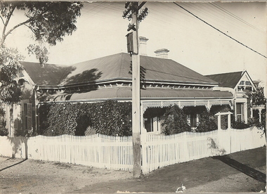
Photograph - T C WATTS & SON - MARLO WILLS STREET, 1929
BHS CollectionBlack and white photograph mounted on rectangular grey board. House, Victorian style pointed brick double fronted large window on left with arched centre, sash windows, 2 narrow window ones either side, decorative tile work columns, galvanised iron roof with chimney. Marlo Wills Street written on back.Frank A. Jeffree Photo Bendigoplace, building, residential, stamped on back in rectangle ''t.c. watts and son/auctioneer/estate agents/253 mitchell street/bendigo'' stamped on back in circle ''royal historical society of victoria, bendigo branch'' -
 Melbourne Tram Museum
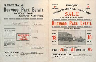
Ephemera - Real estate sale, Duncan & Weller Auctioneers, "Burwood Park Estate" Boundary Road, 1926
Pamphlet advertising the sale of land at the Burwood Park Estate, Boundary Road Burwood, Saturday 4th September. Does not give the year, most likely 1926. Promotes the tram service, nearby shops, the suitability of the soil for gardening and other facilities. Has a photo of possibly W 259 at the terminus. The plan of sub-division shows 18 lots for sale.Demonstrates the style of land sale pamphlet including the availability of tram services to prospective purchasers.Pamphlet - folded - printed in two colours of cream coloured paper with photographs and plans.sale of land, trams, real estate, burwood park, burwood -
 City of Kingston
Pamphlet - Colour, Arthur Tuckett & Son, Auctioneers and Subdivisional Specialists, Auction of Station Estate, Moorabbin, 1923
Sales plan for land in the suburb of Moorabbin, bounded by Railway Crescent, South Road, Jasper Road and Pattersons Road.The developing urban area of Moorabbin within the City of Kingston. This land sale pamphlet illustrates the subdivision of land within the municipality and the changing demographic of the district as new houses are constructed.Colour pamphlet advertising an auction of the Station Estate Moorabbin. Incorporates details of the shopping facilities, proximity to the railway line, variety of schools and churches in the area, and a sales plan for home sites and shop fronts. Incorporates a map of the estate bordered by Pattersons Road, Japer Road, South Road and Railway Crescent. Handwritten in grey pencil top right front page: Station Estate / late [indecipherable] Handwritten in red pencil on subdivision map: x [on majority of properties marked on the map] Handwritten in grey pencil on subdivision map: additional subdivisions drawn in and large lines drawn across the mapmoorabbin, land sales, estate -
 Bendigo Historical Society Inc.
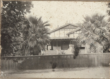
Photograph - T C WATTS & SON COLLECTION: BENDIGO HOUSE, 1927
Brydon Stewart Melrose (1895-1989) was a dentist. He married Florence Emily Reville in 1921. Their home in Myrtle Street was called Morayfield. In the mid to late 1930's they moved to Boundary Street.Black and white photograph mounted on rectangular grey board. House, weatherboard, cement sheet and timber under eaves. Double door entrance. Rough cast cement verandah with timber posts. Two palms in front. Timber top rail to closely slatted wooden fence, chimney pots visible. On back of photo:" Bryden Melrose, £850, Date stamp 9 December 1927. refer S & U, D.T. Coy first'Frank A. Jeffree Bendigoplace, building, residential, stamped on back in rectangle ''t.c. watts and son/auctioneer/estate agents/253 mitchell street/bendigo'' stamped on back in circle ''royal historical society of victoria, bendigo branch'' -
 Bendigo Historical Society Inc.
Photograph - T C WATTS & SON COLLECTION: CARPENTER STREET, BENDIGO, 1927
Alexander Fraser lived at 178 Carpenter Street with his wife Mary. He was a builderBlack and white photograph mounted on rectangular grey board. House, cement rendered double fronted bungalow central porch with apex roof. Flower boxes on porch [PTO] ramp to side door on left. Leadlight windows on top of front door and windows. On back of photo board ' Frasers Carpenter Street, £1200 sewered' Date stamp: 9 December 1927, on back. Sold for £3650 with certain coverings, 19.10.50.Frank A. Jeffree Bendigoplace, building, residential, stamped on back in rectangle ''t.c. watts and son/auctioneer/estate agents/253 mitchell street/bendigo'' stamped on back in circle ''royal historical society of victoria, bendigo branch'' -
 Bendigo Historical Society Inc.
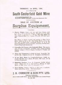
Document - IAN DYETT COLLECTION: AUCTIONEERS - SOUTH COSTERFIELD GOLD MINE
BHS CollectionIan Dyett collection. Auction Thursday, 1st April, 1954, South Costerfield Gold Mine, Costerfield. Sale by auction of surplus equipment, such as, Electric Winder, Caterpillar D.2 tractor with hydraulic blade.business, auctioneers, j h curnow & son pty ltd -
 Bendigo Historical Society Inc.
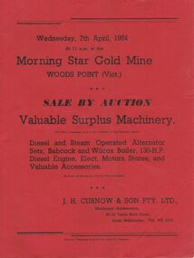
Document - IAN DYETT COLLECTION: AUCTION - MORNING STAR GOLD MINE WOODS POINT
BHS CollectionIan Dyett Collection auction at the Morning Star Gold Mine Woods Point (Vic). To be held on Wednesday, 7th April, 1954 at the site. Valuable Surplus Machinery including diesel and steam operated alternator sets, Babcock and Wilcox Boiler.business, auctioneers, j h curnow & son pty ltd