Showing 33214 items matching "buildings/streetscapes"
-
 Stawell Historical Society Inc
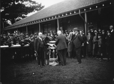
Photograph, Stawell Technical School c1920s opening of new wing of building
Stawell Technical School. Opening of new wing of new Building 1920s. These buildings were used for approximately forty years.Black and white photo of a long brick building with tiled roof, veranda along the building. A large group of people assembled for a special occasion. stawell education -
 Stawell Historical Society Inc
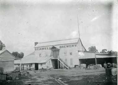
Photograph, Brewery Building of the Stawell Brewery originally owned by Thomas Powell and later Bryant and Co in Stawell West near the Botanical Reserve
Wooden Brewery Building Stawell Brewery originally owned by Thomas Powell and later Bryant and Co. Located Stawell West near the Botanical Reserve. Closed about 1918.Two Story wooden Building with additions to left. Another wooden building partialy shown to left in front of main buildingStawell Breweerystawell, stawell brewery -
 Linton and District Historical Society Inc
Photograph, Former Bennett Bros Garage Building, Sussex Street, Linton, 2014
The Bennett Bros Garage operated in Linton from the 1930s-1950s. The building is at 79A Sussex Street. Next to the garage building can be seen the building at 81 Sussex Street. In the first half of the twentieth century, it was a shop and residence and operated as a greengrocery and confectionery store.Colour photo which shows a brick building in a somewhat dilapidated condition, with windows and doors boarded up. The building has a tiled roof.bennett bros garage, shepherd's greengrocery and confectionery store, jane craine's confectionery shop, 79a sussex street linton, 81 sussex street linton -
 Kew Historical Society Inc
Plan, Melbourne & Metropolitan Board of Works : Borough of Kew : Detail Plan No.1582, 1904
The Melbourne and Metropolitan Board of Works (MMBW) plans were produced from the 1890s to the 1950s. They were crucial to the design and development of Melbourne's sewerage and drainage system. The plans, at a scale of 40 feet to 1 inch (1:480), provide a detailed historical record of Melbourne streetscapes and environmental features. Each plan covers one or two street blocks (roughly six streets), showing details of buildings, including garden layouts and ownership boundaries, and features such as laneways, drains, bridges, parks, municipal boundaries and other prominent landmarks as they existed at the time each plan was produced. (Source: State Library of Victoria)This plan forms part of a large group of MMBW plans and maps that was donated to the Society by the Mr Poulter, City Engineer of the City of Kew in 1989. Within this collection, thirty-five hand-coloured plans, backed with linen, are of statewide significance as they include annotations that provide details of construction materials used in buildings in the first decade of the 20th century as well as additional information about land ownership and usage. The copies in the Public Record Office Victoria and the State Library of Victoria are monochrome versions which do not denote building materials so that the maps in this collection are invaluable and unique tools for researchers and heritage consultants. A number of the plans are not held in the collection of the State Library of Victoria so they have the additional attribute of rarity.Original survey plan, issued by the MMBW to a contractor with responsibility for constructing sewers in the area identified on the plan within the Borough of Kew. The plan was at some stage hand-coloured, possibly by the contractor, but more likely by officers working in the Engineering Department of the Borough and later Town, then City of Kew. The hand-coloured sections of buildings on the plan were used to denote masonry or brick constructions (pink), weatherboard constructions (yellow), and public buildings (grey). Public buildings, coloured grey on the Plan 1582 include the police station and post office, churches and schools. The earliest church school, Common School No.356 was located at the rear of the Congregational Church in Peel Street. It was constructed in 1859. The first buildings of Kew Primary School No.1075 on the other side of Peel Street were constructed in 1871. The school in 1903 only occupied a small fraction of its current site. In 1903, where the rear playground is now located, were two weatherboard and one brick villa. Trinity Grammar School was founded in 1902 and opened in the Parish Hall at the rear of Holy Trinity Anglican Church. It was not to move to its current site until 1906. The outline of the building housing the Kew Fire Brigade in the centre of the north side of Walton Street is shown but not named on the plan. Further down Pakington Street stood the two-storey Italianate mansion ‘Overton’. The home of Stanford Chapman, it was to be featured in the Imperial Institute series of bromide photographs of Victoria, Vol. 1: Homes and scenery. It was later to become a boarding house before it was later demolished.melbourne and metropolitan board of works, detail plans, maps - borough of kew, mmbw 1582, cartography -
 Rutherglen Historical Society
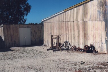
Image, c1990
This photograph is of the side of the main building of the Gold Battery with workshop at rear (now demolished). Beside building is a hand windlass, along with some old pulleys and various parts. This is one of a series of photographs of the Rutherglen Gold Battery. The battery's purpose was to crush quartz from nearby quartz reefs and extract gold from within. The battery was erected in 1908 and consists of a five-head battery, Wilfrey table, Bergin pan, portable steam engine and shed. The battery was restored in 2011/12 and can be viewed daily between 9.00am and 5.00pm. See website for details.Colour photograph of the side of a corrugated iron building with a smaller building at the left, and a number of pieces of machinery next to the buildinggold battery, gold processing -
 University of Melbourne, Burnley Campus Archives
Photograph - Black and white print, 703/7, 24 July 1948
24/7/48. "The new building rises to displace the Old Pavilion which is soon to be demolished." "The new building is nearly finished." THK"24/7/48." "The new building rises to displace the Old Pavilion which is soon to be demolished." "The new building is nearly finished." THKbuilding, old pavilion, demolition, e. m. gibson collection -
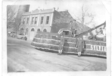 Ballarat Tramway Museum
Photograph - Black & white - SEC Procession float, 1944
Photo of the decorated or motorised float used in a fund raising event for Mrs Sylvia Mitchel. Has a number of the conductresses standing alongside or atop the float. In the background is the SEC Ballarat Office building. Has the word "Sylvia" on one side of the float.Yields information about the SEC fund raising float for Sylvia Mitchell.Black and white printed photo with ruled or lined paper on rear.Old SEC building corner of Ripon St and Wendouree Pde.most popular conductress, sylvia mitchell, conductor, conductress, tramways, sec, red cross -
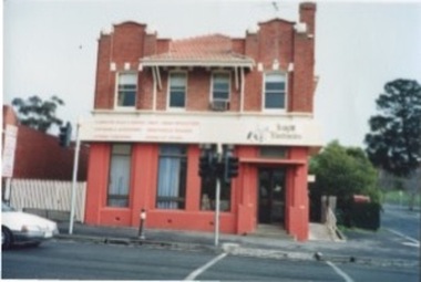 Kilmore Historical Society
Photograph, 27 Sydney Street, 06/06/1996
Was the building which housed the State Bank before it moved to 40 Sydney Street.15cm x 10cm colour photograph of the building 27 Sydney Street. Double story building with the bottom floor in a red render and the rest of the building in a red brick. The building is occupied by Knight Electronics (Leading Edge Computers). There is a sign stating the services of the store.Written on the back: 27 Sydney St., Kilmore. 6th June 1996 Photo: Heather Knightbanks and banking, shopfronts, retail stores, storefronts -
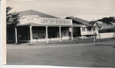 Phillip Island and District Historical Society Inc.
Photograph, 1959
Donated by Jack JennerBlack & White photograph of the Phillip Island co-op on the cnr Chapel Street & Thompson Avenue, Cowes. Two weatherboard houses to the right of building. Three Pine trees.On back: "Site of Southern Trading Store immediately before building. Date should be easy to obtain" (August 1959)phillip island co-op store, chapel street cowes, thompson avenue cowes, phillip island, jack jenner -
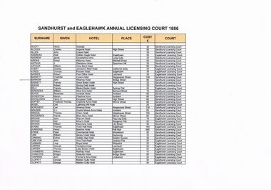 Bendigo Historical Society Inc.
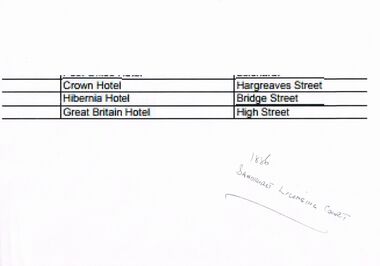
Document - PHOTOCOPY OF SANDHURST AND EAGLEHAWK ANNUAL LICENSING COURT 1886
... buildings/streetscapes ...Photocopy of Sandhurst and Eaglehwk Annual Licensing Court 1886 record indicating the applicant, Barrow, John, the name of the Hibernia Hotel and the amount of the fee due, £60 (pounds)bendigo, history, buildings/streetscapes -
 Bendigo Historical Society Inc.
Document - ENLARGEMENT OF AN ARTICLE IN RELATION TO THE LOCATION OF THE HIBERNIA HOTEL
... buildings/streetscapes ...Enlargement of an article (1886) on the location of the Hibernia hotel in Bridge street,bendigo, history, buildings/streetscapes -
Bendigo Historical Society Inc.
Book - HEALTHY GOLDEN BENDIGO, 1906
... buildings/streetscapes ...Healthy Golden Bendigo The Paradise of Sunshine, The Riviera of the Southern Hemisphere. The most favored spot in Australia for Vicitors and Tourists. Views places of interest with descriptive matter. Plans of the lines of reef. Records of the World's Premier Goldfield.Bendigo Progress Association.bendigo, history, buildings/streetscapes -
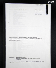 Bendigo Military Museum
Administrative record - Design Brief for Refurbishment of Facilities at "Fortuna Villa", Peter Jordan Architects, 55 Clements St, South Yarra, Vic 3141, 1994
Refurbishment Plans for building Works at Fortuna Villa, Building 23 (Ordinary Ranks Accommodation Barracks) were completed, Building 8 works were never commenced.Plastic Covered Book, A4 Pages, Building plansPeter Jordan Architects, 55 Clements St, South Yarra, Vic, 3141royal australian survey corps, rasvy, fortuna, army survey regiment, army svy regt, asr -
 Lakes Entrance Historical Society
Photograph - Building of PS Curlip, 1/01/2006 12:00:00 AM
building of PS Curlip replica in old butter factory building Orbost VictoriaBuilt as tourist attraction on river at Marlo. Plus 6 other photos Colour photograph showing building of PS Curlip replica in old butter factory building Orbost Victoria. Plus 9 other photos tourism, boat building -
 Stawell Historical Society Inc
Photograph, Stawell Post Office Cnr Wimmera and Main Streets 1975
Stawell Post Office on corner of Wimmera and Main Streets. Erected 1875. Phone box and car at right of photo. Directional sign on the left side of the building. The Fruit Vegs building on the right side has replaced the Akins building on the right side in an earlier photo.Black & white photograph of a two storey building built in 1875. Out the front of the building is a signpost, bench seat, phone box and car in the foreground. A flag pole protrudes from one of the windows on the top storey. On the right side of the photo is a Fruit Vegs sign on the awning of the building next door. A directional sign post is on the left side of the building stawell -
 Rutherglen Historical Society
Image, c1990
This photograph is of the back end of the side of the main building of the Gold Battery with workshop at rear (now demolished). Beside building is a hand windlass, along with some old pulleys and various parts. This is one of a series of photographs of the Rutherglen Gold Battery. The battery's purpose was to crush quartz from nearby quartz reefs and extract gold from within. The battery was erected in 1908 and consists of a five-head battery, Wilfrey table, Bergin pan, portable steam engine and shed. The battery was restored in 2011/12 and can be viewed daily between 9.00am and 5.00pm. See website for details.Colour photograph of the side of a corrugated iron building with a smaller building at the left, and a number of pieces of machinery next to the buildinggold battery, gold processing -
 Phillip Island and District Historical Society Inc.
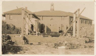
Photograph, 1927
Photo shows the completer Bell Tower and the starting of the next extension of St Pauls building.The building nears completionlocal history, photography, photographs, slides, film, st pauls training school, schools, phillip island, sepia photograph, ken pound -
 Phillip Island and District Historical Society Inc.
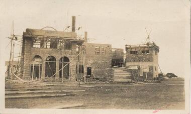
Photograph, 1927
A photograph of the progress of the building of St Pauls Home, the bricks were in place. Photo showing the arches of the 2 storey brick construction.Building progressed to the brick construction. Sepia photograph of the 2 storey building. Photo showing the arches of the 2 storey brick construction with scaffolding and building supplies.local history, photography, photographs, slides, film, st pauls training school, schools, phillip island, sepia photograph, ken pound -
 Phillip Island and District Historical Society Inc.
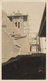
Photograph, 1927
This photo shows building of tower with scaffolding and the builders on the top.Building of St Pauls tower.local history, photography, photographs, slides, film, st pauls training school, schools, phillip island, sepia photograph, ken pound -
 Sunbury Family History and Heritage Society Inc.
Photograph, Bulla Primary School, c1993
The weatherboard building was one of three erected in the former Bulla Primary School grounds. The original school building was constructed from bluestone as was the case with many other buildings in the district. A non-digital coloured photograph of a cream weatherboard building with brown trims. There are tall conifers and gum trees trees in the background and a concrete pathway leading to the building's front door.bulla primary school, school buildings -
Glenelg Shire Council Cultural Collection
Card - Cards - Foresters' Hall, n.d
Three cards, buff colour, printed on front with image of Foresters' Hall, blank inside, made and sold as a fundraiser for restoration of historic buildings in PortlandBack: ' "FORESTERS' HALL" (1842) GAWLER ST. , PORTLAND. Proceeds from the sale of this card will assist in the restoration of historic buildings in Portland' -
 Kiewa Valley Historical Society
Photographs – Holland Street North, Mt Beauty. Circa 1993. Set of 18 colour photographs
Established in 1946, during the construction of the Kiewa Hydro Electric Scheme, the township of Mt Beauty was developed by the State Electricity Commission of Victoria to provide additional accommodation for the thousands of workers during the construction of the country’s second largest hydro-electricity scheme. Although these towns were built as temporary accommodation for the workers and their families, many stayed after the scheme finished. Combined with the influx of European migrants, with their rich cultural backgrounds, all played a major part in shaping the future character of the Mount Beauty, the Kiewa Valley and Falls Creek. The Bright Council, now the Alpine Shire took over the control of the township in 1960. This relatively young town of Mount Beauty, along with the surrounding townships of Falls Creek, Bogong, Tawonga South and Tawonga, are all part of a prospering tourist area with excellent services, accommodation, food and a wide range of recreational activities available for all ages. According to Shire records, the population of Mt Beauty has grown from 1,500 in 1981 to 1,800 in 2016 with a projected increase to 2,000 in 2013The photographs taken around 1993 show a prosperous commercial centre catering for both locals and the needs of visitors. It provides a pictorial history of the changes which have occurred in the retail/commercial district of Mt Beauty over the years. It also demonstrates the attention paid by Alpine Shire towards providing accessible recreational green space around the town centre.Set of 18 colour photographs Holland Street North, Mt Beauty. Circa 1993 showing retail services and streetscape of the time. No markingsholland st mt beauty, mt beauty -
 Kiewa Valley Historical Society
Photographs – Holland Street South, Mt Beauty. Circa 1993. Set of 16 colour photographs
Established in 1946, during the construction of the Kiewa Hydro Electric Scheme, the township of Mt Beauty was developed by the State Electricity Commission of Victoria to provide additional accommodation for the thousands of workers during the construction of the country’s second largest hydro-electricity scheme. Although these towns were built as temporary accommodation for the workers and their families, many stayed after the scheme finished. Combined with the influx of European migrants, with their rich cultural backgrounds, all played a major part in shaping the future character of the Mount Beauty, the Kiewa Valley and Falls Creek. The Bright Council, now the Alpine Shire took over the control of the township in 1960. This relatively young town of Mount Beauty, along with the surrounding townships of Falls Creek, Bogong, Tawonga South and Tawonga, are all part of a prospering tourist area with excellent services, accommodation, food and a wide range of recreational activities available for all ages. According to Shire records, the population of Mt Beauty has grown from 1,500 in 1981 to 1,800 in 2016 with a projected increase to 2,000 in 2013The photographs taken around 1993 show a prosperous commercial centre catering for both locals and the needs of visitors. It provides a pictorial history of the changes which have occurred in the retail/commercial district of Mt Beauty over the years. It also demonstrates the attention paid by Alpine Shire towards providing accessible recreational green space around the town centre.Set of 16 colour photographs Holland Street South, Mt Beauty. Circa 1993 showing retail services and streetscape of the time. No markingsholland st mt beauty, mt beauty -
 Bendigo Historical Society Inc.
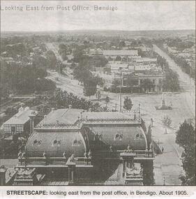
Newspaper - JENNY FOLEY COLLECTION: STREETSCAPE
Bendigo Advertiser "The way we were" from 1999. Streetscape: looking east from the post office, Bendigo. About 1905.newspaper, bendigo advertiser, the way we were -
Clunes Museum
Book, GEOFF ARNOTT, REMEMBERING WEDDERBURN & NEIGHBOURING TOWNS
HISTORICAL RECOLLECTION OF WEDDERBURN AND SOUNDING TOWNSSOFT COVER BOOK, VARIOUSLY STREETSCAPE, RAILWAY STATION AND PUB IMAGES ON FRONT COVER, TOWN IN FOOD IMAGE ON BACK COVERnon-fictionHISTORICAL RECOLLECTION OF WEDDERBURN AND SOUNDING TOWNSwedderburn history, wedderburn townships -
 Federation University Historical Collection
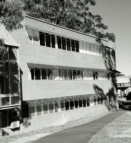
Photograph, Building E, Mount Helen Campus by Lucie Akers, 2023
Building at Mount Helen Campus, Federation University. Currently (2024) holds Tafe, ITS, Paramedicine and ChildcareSide view of Building E at Mount Helen Campus. This building was designed by architect Ewan Jones. brutalism, federation university australia, mount helen campus, architect, education, building e, building, tafe, its, paramedicine, ewan jones and associates -
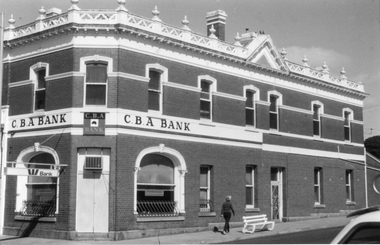
 Stawell Historical Society Inc
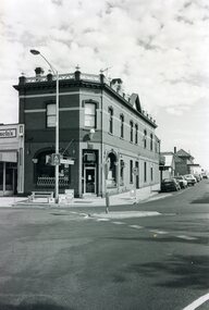
Photograph - Commercial Bank of Australia or Australiasia, C.B.A. Bank on the corner of Wimmera and Main Sts
This photograph is of a two storey bank on the corner of Wimmera & Main St's Stawell. It was used by the Commercial Bank of Australia. The building was originally built as Langford's chemist and now privately owned. Black & White photograph of a brick two storey building situated on a street corner. The building has a decorative parapet. CBA bank is written on the building but has a Westpac Bank neon sign on the side of the building.stawell shops -
 Stawell Historical Society Inc
Photograph - Commercial Bank of Australia or Australiasia, C.B.A. Bank on the corner of Wimmera and Main Sts
This photograph is of a two storey bank on the corner of Wimmera & Main St's Stawell. It was used by the Commercial Bank of Australia. The building was originally built as Langford's chemist and now privately owned. Black & White photograph of a brick two storey building situated on a street corner. The building has a decorative parapet. CBA bank is written on the building but has a Westpac Bank neon sign on the side of the building.stawell shops -
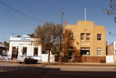 Charlton Golden Grains Museum Inc
Photograph, High St Charlton, centre, south side 1987, c.1987
High St Charlton, centre, southside. ANZ Bank, formerly Bank of Australasia built in 1892. State Bank building rebuilt in 1940. Part of Shire of Charlton 1987 series.Colour photo graph of ANZ Bank and State Bank buildings in High St Charlton. The ANZ building is single storey and is painted blue and white. The State Bank building is a two storey brick building with red bricks on the lower half of the building and cream bricks above. A blue and white station wagon is parked in front of the ANZ building.high st charlton, anz bank, bank of australasia, state bank, charlton, business, industry -
 Wangaratta Urban Fire Brigade
Photograph
Building of the CFA training ground in Shanley St Wangaratta3 black and photos.1, .2 CFA training ground 1985 .3 Building CFA training ground 1985training ground, 1985