Showing 5141 items matching "fifth-avenue"
-
 Eltham District Historical Society Inc
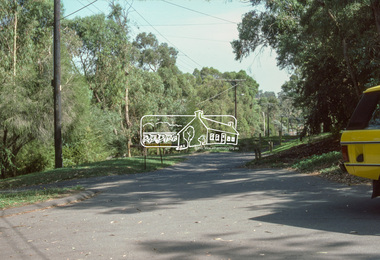
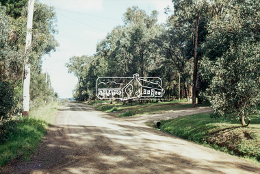
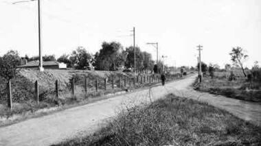
Slide - Photograph, Shalbury Avenue, Eltham, c.Mar. 1985
Shalbury Avenue, Eltham, C.Mar. 198535mm colour positive transparency (1 of 15) Mount - Kodak Kodachrome Cardinfrastructure, roads, eltham, shalbury avenue -
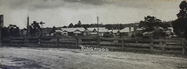
 Ringwood and District Historical Society
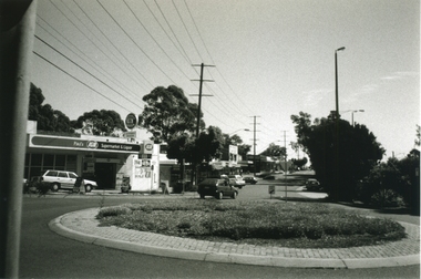
Photograph-B&W, Joan Walker, East Ringwood 2000- Roundabout in Railway Avenue cnr Wenwood Street looking West (railway line on right hand side), 2000
East Ringwood 2000- Roundabout in Railway Avenue cnr Wenwood Street looking West (railway line on right hand side)- B&W Photo from Album 6501 -
 Eltham District Historical Society Inc
Photograph, Baldwin Avenue at Lilicur Road, Montmorency, c.1972, 1972c
Shire of Eltham road construction and realignment works on Baldwin Avenue, Lilicur Road and Price Avenue, Montmorency, c.1972 Cross Ref: EDHS_03867 (1972) EDHS_04005-10 (1980) EDHS_04774-1 (2019)35mm colour positive transparency blue Agfacolour Service plastic mountbaldwin avenue, infrastructure, lilicur road, montmorency, road construction -
 Greensborough Historical Society
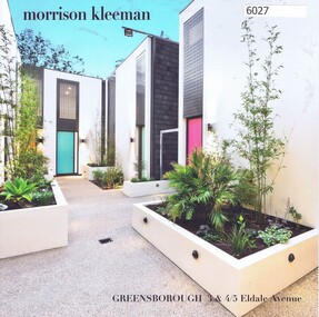
Advertising Leaflet, 3 & 4/5 Eldale Avenue Greensborough, 14/03/2018
3/5 Eldale Avenue Greensborough, 2 bedroom town house, sold March 2018 for $595,000. Previous sales: June 2000 $184,000. 4/5 Eldale Avenue sold February 2018 for $610,000Real Estate advertising leaflet,1 sheet folded into 4 pages, printed in colour both sides.eldale avenue greensborough -
 Greensborough Historical Society
Photograph - Digital Image, Somers Avenue Macleod, 1950s
Digital of streetscape, possibly Somers Avenue Macleod.Digital image of black and white photograph.somers avenue macleod -
 Greensborough Historical Society
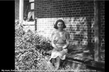
Photograph - Digital Image, Evelyn Roberts on the porch at Scotland Avenue 1939, 1939_
Evelyn Roberts on the porch at Scotland Avenue 1939.Digital copy of black and white photograph.evelyn roberts, roberts family, scotland avenue greensborough -
 Eltham District Historical Society Inc
Photograph, Baldwin Avenue at Sherbourne Road, Montmorency, c.1972, 1972c
Shire of Eltham road construction and realignment works on Baldwin Avenue, Lilicur Road and Price Avenue, Montmorency, c.1972 Cross Ref: EDHS_03878 (1972) EDHS_04005-9 (1980) EDHS_04774-2 and EDHS_04774-3 (2019)35mm colour positive transparency blue Agfacolour Service plastic mountbaldwin avenue, infrastructure, road construction, sherbourne road -
 Ringwood and District Historical Society
Photograph-B&W, Joan Walker, East Ringwood 2000- Railway Avenue looking West (Dr's McCubbin,McDonald,Mc Neil,Ziccone,Worboys,Brownless) & Dentist O'Connor, 2000
East Ringwood 2000- Railway Avenue looking West (Dr's McCubbin,McDonald,Mc Neil,Ziccone,Worboys,Brownless) & Dentist O'Connor- B&W Photo from Album 6501 -
 Whitehorse Historical Society Inc.
Article, Prized Penllyne Avenue, 1991
28 Penllyne Avenue, Vermont, built in 1952 is for sale. Its owners ran the doll hospital in Royal Arcade.28 Penllyne Avenue, Vermont, built in 1952 is for sale. Its owners ran the doll hospital in Royal Arcade. Built on a double block its potential lies in sub-divisional qualities.28 Penllyne Avenue, Vermont, built in 1952 is for sale. Its owners ran the doll hospital in Royal Arcade. penllyne avenue, vermont, no 28, auctions -
 Whitehorse Historical Society Inc.
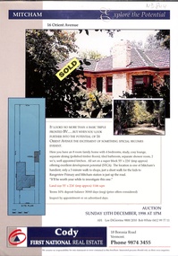
Pamphlet, Orient Avenue, Mitcham, 1/12/1998
Auction brochure for 16 Orient Avenue, Mitcham, 13 December 1998. 4 bedroom brick veneer house. Agent: Cody First National Real Estate, Boronia Road, Vermont.orient avenue, mitcham, no 16, auctions -
 Ringwood and District Historical Society
Photographs, 1979-80 MMBW pipe line project at Hubbard Reserve, North Ringwood � Grating over hole in Chalkley's 41 Burlock Avenue
Part of a 43-photo record of the MMBW�s engineering feat in drilling a 12 inch pipe line up to 40 feet deep through rock hardened by volcanic action associated with geological fault that occurs along the line. The work took place from October 1979 to May 1980 on the southern boundary of Hubbard Reserve, North Ringwood. The collection was presented to the Ringwood Historical Research Group by J Clarke on 9th June 1980.E560 N25 Jan 1980 A43 Grating over hole 37 feet deep in Chalkley's 41 Burlock Avenue (lot 8) -
 City of Ballarat Libraries
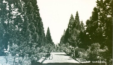
Photograph - Card Box Photographs, Conifer Avenue, Ballarat Botanic Gardens circa 1900
Two men on bicycles rest along an avenue of conifers.ballarat botanic gardens, gardens, persons, vehicles, public -
 Eltham District Historical Society Inc
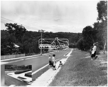
Photograph, Shire of Eltham, Montmorency - Calrossie Avenue (newly constructed road and footpaths), November 1966
New paved road, footpaths and gutters on Calrossie Avenue, Montmorency.This photo forms part of a collection of photographs gathered by the Shire of Eltham for their centenary project book, "Pioneers and Painters: 100 years of the Shire of Eltham" by Alan Marshall (1971). The collection of over 500 images is held in partnership between Eltham District Historical Society and Yarra Plenty Regional Library (Eltham Library) and is now formally known as 'The Shire of Eltham Pioneers Photograph Collection.' It is significant in being the first community sourced collection representing the places and people of the Shire's first one hundred years.Digital imagesepp, shire of eltham pioneers photograph collection, montmorency, calrossie avenue, road construction, footpaths -
 Eltham District Historical Society Inc
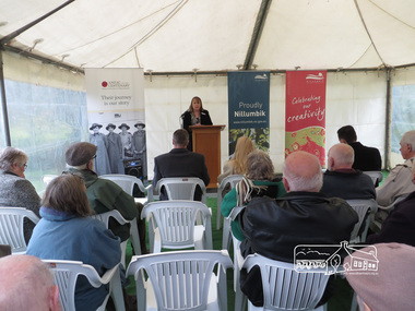
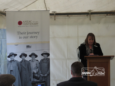
Photograph, Dedication of new Avenue of Honour Memorial, Main Road, Eltham, 2 June 2015, 2 June 2015
Cr Helen Coleman speaks at the dedication of the new Avenue of HonourBorn Digitalavenue of honour, war memorials, plaques, main road, eltham, helen coleman -
 Eltham District Historical Society Inc
Photograph, Dedication of new Avenue of Honour Memorial, Main Road, Eltham, 2 June 2015, 2 June 2015
Cr. Helen Coleman speaks at the launch of the new Avenue of HonourBorn Digitalavenue of honour, war memorials, plaques, main road, eltham, helen coleman -
 Stawell Historical Society Inc
Photograph, O’Callaghan Street & Clifton Avenue corner Stawell 2004
Street Scene Cnr. O’Callaghan St. & Clifton Avenue. 2004stawell -
 Malmsbury Historical Society
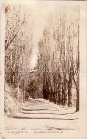
Postcard (Item), Postcard Poplar Avenue Malmsbury Gardens Rose P4157, Malmsbury c1923
Associated with - Rose Series P4157 Buildings - "Poplar Avenue, Gardens" -
 Malmsbury Historical Society
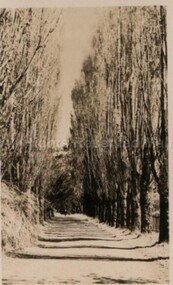
Postcard (Item), Postcard Poplar Avenue Malmsbury Gardens Rose Series P4157, Malmsbury c1923
Associated with - Rose Series P4157 Buildings - "Poplar Avenue, Gardens" -
Whitehorse Historical Society Inc.
Article, Crash Capital of Australia, 2017
Springvale Road is the nation's worst for insurance claims for the fifth year in a row.Springvale Road is the nation's worst for insurance claims for the fifth year in a row.Springvale Road is the nation's worst for insurance claims for the fifth year in a row.whitehorse road, traffic, accidents, maroondah highway -
 Greensborough Historical Society
Photograph - Digital Image, Anne Paul, Cherry Street Macleod - Avenue of Honour, 26/06/2019
Photographs of the Avenue of Honour in Cherry Street Macleod. Established in 1919 as a memorial to service men and women who gave their lives in World War 1, the Avenue is a single row of sugar gums, the former Mont Park hospital grounds are adjacent. These photographs show the plaque. Digital copy of 3 colour photographs.macleod avenue of honour, cherry street macleod -
 Ringwood and District Historical Society
Photographs, 1979-80 MMBW pipe line project at Hubbard Reserve, North Ringwood � View behind no. 39 Burlock Avenue showing compressor, mole pit cover and the big box tree
Part of a 43-photo record of the MMBW�s engineering feat in drilling a 12 inch pipe line up to 40 feet deep through rock hardened by volcanic action associated with geological fault that occurs along the line. The work took place from October 1979 to May 1980 on the southern boundary of Hubbard Reserve, North Ringwood. The collection was presented to the Ringwood Historical Research Group by J Clarke on 9th June 1980.E560 N26 Jan 1980 A43 View behind no. 39 Burlock Avenue showing compressor, mole pit cover and the big box tree -
 Ringwood and District Historical Society
Photographs, 1979-80 MMBW pipe line project at Hubbard Reserve, North Ringwood � Manhole behind 29 Burlock Avenue
Part of a 43-photo record of the MMBW�s engineering feat in drilling a 12 inch pipe line up to 40 feet deep through rock hardened by volcanic action associated with geological fault that occurs along the line. The work took place from October 1979 to May 1980 on the southern boundary of Hubbard Reserve, North Ringwood. The collection was presented to the Ringwood Historical Research Group by J Clarke on 9th June 1980.E566 N5 13 May 1980 A43 Manhole behind 29 Burlock Avenue, 38 feet deep. Debbie place is on the far right. -
 Ringwood and District Historical Society
Photograph, View of buildings on Maroondah Highway, Ringwood, taken overlooking railway yard from Station Street and Greenwood Avenue - 1914
Enlarged copy of smaller archived photograph - view of buildings on Maroondah Hwy taken overlooking railway yard from Station Street and Greenwood Avenue, 1914. Black and white photo on heavy cardboard backing. -
Kew Historical Society Inc
Archive (Sub-series) - Subject File, Canoe Tree (Bowyer Avenue, Kew), 1958
Various partiesReference, Research, InformationSecondary Values (KHS Imposed Order)Subject file containing correspondence, copies of Society Minutes and extended research by Eva Grant (2pp) on the former canoe Tree in Bowyer Avenue. The file notes the wording of the plaque, erected in 1965, and a photograph of it in situ.canoe trees - kew (vic), plaques - kew (vic)canoe trees - kew (vic), plaques - kew (vic) -
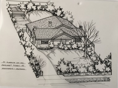 Kew Historical Society Inc
Drawing - Property Illustration, Margaret Picken, 25 Florence Avenue, Kew, 1997
This architectural drawing is one of a series created by Margaret Picken for a number of real estate agents in Melbourne between 1983 and 2005. Each work is signed and dated by the artist.Gift of Margaret Picken, 2020Pen and ink architectural drawing on drafting film of 25 Florence Avenue, Kew; made by Margaret Picken in 1997. A permit to demolish the house was granted by the City of Boroondara in 2006. A new house was subsequently erected.25 FLORENCE AVE., KEW / MARGARET PICKEN '97 / WOODARDS ~ HAWTHORNartist -- margaret picken 1950-, architectural drawings -- houses -- kew (vic.), 25 florence avenue - kew (vic). -
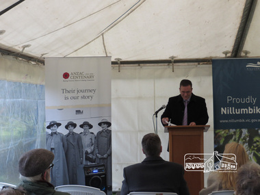 Eltham District Historical Society Inc
Photograph, Dedication of new Avenue of Honour Memorial, Main Road, Eltham, 2 June 2015, 2 June 2015
Minister for Veterans, John Eren at the official opening of the Eltham Avenue of Honour markers.,Born Digitalavenue of honour, war memorials, plaques, main road, eltham, john eren -
 Eltham District Historical Society Inc
Photograph, Baldwin Avenue from Lilicur Road, Montmorency, c.1972, 1972c
Shire of Eltham road construction and realignment works on Baldwin Avenue, Lilicur Road and Price Avenue, Montmorency, c.1972 Sherbourne Road in distance Ref: EDHS_03875 (1972) and EDHS_04774-4 (2019) from opposite ends showing realignment of road at intersection of Sherbourne and the same Cypress tree35mm colour positive transparency blue Agfacolour Service plastic mountbaldwin avenue, infrastructure, lilicur road, montmorency, road construction, sherbourne road -
 Ringwood and District Historical Society
Photographs, 1979-80 MMBW pipe line project at Hubbard Reserve, North Ringwood � The work on sewer line from 29-39 Burlock Avenue
Part of a 43-photo record of the MMBW�s engineering feat in drilling a 12 inch pipe line up to 40 feet deep through rock hardened by volcanic action associated with geological fault that occurs along the line. The work took place from October 1979 to May 1980 on the southern boundary of Hubbard Reserve, North Ringwood. The collection was presented to the Ringwood Historical Research Group by J Clarke on 9th June 1980.E561 N11 3 March 1980 A43 The work on sewer line from 29-39 Burlock Avenue. Lundy-Clarke's place on sky-line. -
 Ringwood and District Historical Society
Photographs, 1979-80 MMBW pipe line project at Hubbard Reserve, North Ringwood � Line of tunnel shafts behind 29-39 Burlock Avenue
Part of a 43-photo record of the MMBW�s engineering feat in drilling a 12 inch pipe line up to 40 feet deep through rock hardened by volcanic action associated with geological fault that occurs along the line. The work took place from October 1979 to May 1980 on the southern boundary of Hubbard Reserve, North Ringwood. The collection was presented to the Ringwood Historical Research Group by J Clarke on 9th June 1980.E561 N10 Feb 1980 A43 Line of tunnel shafts behind 29-39 Burlock Avenue. Horizontal gantry was above the manhole in the corner of No. 29. -
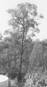 Ringwood and District Historical Society
Photograph, Red box tree at rear of 39 Burlock Avenue (no date)
Written on back of photograph, "Paul's shot of the big box tree from the top of the shed". Also, "Red box tree at rear of 39 Burlock Avenue".