Showing 1947 items matching "floods"
-
 Unions Ballarat
The cardigan mine disaster (Don Woodward Collection), Atkinson, Jeffrey, 2002
An account of the flooding of the Cardigan mine (near Ballarat) in 1902. Four men died and five were rescued from the mine.Workplace safety and Ballarat historical relevance.Book; 58 pages. Front cover: light green background; dark green graphic of the mine; black lettering; author's name and title.Title page: price - $18.50 - in pencil.btlc, ballarat trades hall, ballarat trades and labour council, occupational health and safety, cardigan mine, gold mining - ballarat -
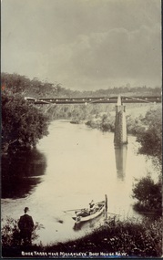 Kew Historical Society Inc
Postcard, River Yarra near Macauleys' Boathouse Kew, c.1910
The Pipe Bridge was constructed to bring fresh water from Fairfield to Kew. This bridge was destroyed in the 1934 Flood and later reconstructed.Early sepia real photo postcard of the first Pipe Bridge bringing water from the Yan Yean Reservoir to Kew. The site is upriver of the original Macauley's boathouse. Obverse: "River Yarra near Macauleys' Boat House Kew". Reverse: "(Pipe Water Line) / Kew to Fairfield above boat house / Pipe Bridge / Received from L. Bennett 1980".bridges - kew (vic.), bridges - yarra river -- kew (vic.), pipe bridge -
 Orbost & District Historical Society
postcard, C1920-1940
This photograph shows the second major bridge across the Snowy River at Orbost. The current Snowy River bridge is the fourth to provide a crossing to the township of Orbost. The first, in 1891, lasted just two years before it succumbed to flood waters. The bridge in this photograph was built in the 1920s as a road and rail bridge, and was again partly washed away by flood waters in 1934. After the end of the first World War the Victorian Railways considered an extension of the railhead across the river at Orbost, and in 1922 a new timber and steel girder structure, a joint Country Roads Board — Victorian Railways venture, was built and completed at a cost of £41,000 (the steel girders came from the Flinders Street viaduct reconstruction). Subsequently it was decided not to take the railway across the river, and the bridge was only used by road traffic. It was severely battered by floods during its life. and after the 1971 floods was eventually replaced by the current bridge in 1975. (info from Newletter 54N by John Phillips) This item is an early pictorial record of the previous Snowy River bridge at Orbost.A postcard with a black / white photograph of a bridge - timber and steel girder structure - across the Snowy River at Orbost, Reflections of the bridge are seen in the water.snowy-river-bridge-orbost -
 Orbost & District Historical Society
plan, before 1948
Drainage infrastructure was developed and maintained in this region by the Snowy River Improvement Trust. The Trust was administered by a local committee and its activities funded by a local rate charged on the farmers and land owners in the Trust’s designated district. The level of the rate charged by the Trust was designed to be proportionate to the benefit derived from the works undertaken. Financial assistance was provided by the State Government from time to time for specific projects such as post flood repairs but not for new capital works. The Trust undertook new drainage and river management works including tree planting, rock beach construction and servicing of the drains and flood gates. The Trust also provided a personal flood warning service to the farmers in its district. The Trust ceased to operate in 1997 with the advent of the East Gippsland Catchment Management Authority. The infrastructure developed by the Trust continues to provide a service to the farmers in the region. (ref. 4 East Gippsland CMA Submission to Inquiry into Flood Mitigation Infrastructure in Victoria) This plan is significant as a historical document. The Snowy River Improvement Trust was vital to the Orbost district because of its ability to apply local knowledge and to engage the local farming community.A large plan of divisions of land for the purpose of levying the Snowy River Improvement District - Bete Bolong, Orbost, Waygara, Newmerella and Orbost East. The properties are coloured according to levy amount. The scale is 1" - 20 chains. snowy-river-improvement-trust -
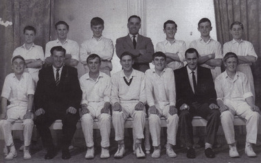 Blackburn Cricket Club
Under 16s Premiers 1961-62
Standing (L-R): P Berg, Geoff Lawson, Peter Cullen, Erin Hutchins (Manager), R Butterworth, A Houghton, R Gibbons. Sitting: John Prohasky, Silver Flood (President), N Franlin, Trevor Hutchins (c), Alan Brandhoff (vc), Allan Berry (Secretary), Wayne Bruce -
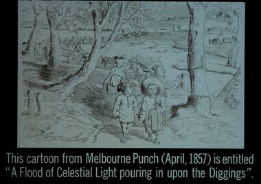 Bendigo Historical Society Inc.
Slide - DIGGERS & MINING. THE CHINESE ON THE GOLD FIELDS, c1857
Diggers & Mining. The Chinese on the Gold Fields. Slide: This cartoon from Melbourne Punch (April, 1857) is entitled ''A Flood of Celestial Light pouring in upon the Diggings''. Slide shows a large group of Chinese travelling to their destination, most of them are on foot. Some onlookers. Markings: 22. Used as a teaching aid.hanimounteducation, tertiary, goldfields -
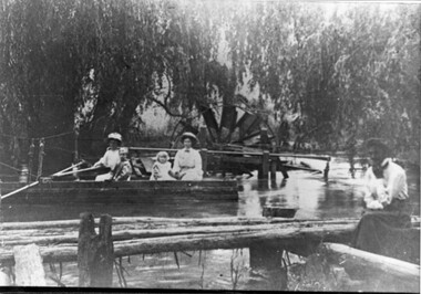 Kiewa Valley Historical Society
Photo - Water Wheel and Punt on the Kiewa River - Tangambalanga Homestead
In early times, Homesteads were part of pastoral runs many of which had frontage onto a river.Tangambalanga Homestead, on the Kiewa River, was subdivided in 1862 from T. Mitchell to Thomas BrownBlack and white shiny photo with women and children in a boat on 'flood' waters and a woman on the bank near a footbridge or jetty. The ladies are wearing hats, long skirts and blouses. In the background there is a large water wheel and trees. This photo is published on Page 19 of 'A History of the Kiewa Valley' by Esther Temple and David Lloyd.tangambalanga homestead, water wheel on the kiewa river, punt on the kiewa river -
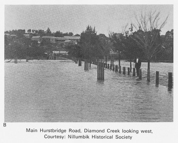 Eltham District Historical Society Inc
Work on paper (Sub-Item) - Photograph, Main Hurstbridge Road, Diamond Creek looking west
Undated black and white photograph of Main Hurstbridge Road, Diamond Creek in flood looking west. Nillumbik Historical Society collectionflood, diamond creek, nillumbik historical society -
 Greensborough Historical Society
Slide - Photograph, John Ramsdale, River flood plain looking west: Slide 67, 1990s
Photograph shows a rural scene with water over ground. This is the Plenty River flood plain looking west, Yan Yean or MerndaPart of the John Ramsdale collection of slides and audio visual material.Colour photograph scanned from slide.No maker's marks. No caption on slide.plenty river, yan yean, mernda -
Tatura Irrigation & Wartime Camps Museum
Booklet, River Improvement & Land Drainage, 1952
River improvement and land drainage and flood protection with spectial reference to the nature and operation of land drainage legislation in Great Britain 1952Grey cover, black writing. Includes fold out mapsirrigation, books, history, local -
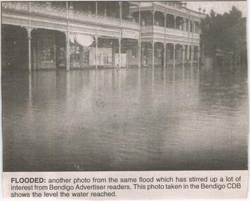 Bendigo Historical Society Inc.
Newspaper - JENNY FOLEY COLLECTION: FLOODED
Bendigo Advertiser ''The way we were'' from 2003. Flooded: another photo from the same flood which has stirred up a lot of interest from Bendigo Advertiser readers. This photo was taken in the Bendigo CBD shows the level the water reached. The Way we were picture confusion: the way we were picture in the Bendigo Advertiser on February 5 is in fact not Bendigo at all. I believe the picture taken is of Rochester, Victoria. The two main buildings pictured are the Shamrock hotel and the Commercial hotel and next to that hidden behind the tree is the old Westpac building. T. Parsons, the name in the photo, used to be a clothing merchant in Rochester. Written by Brian Leahy, Rochester. The clip is in a folder.newspaper, bendigo advertiser, the way we were -
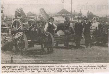 Bendigo Historical Society Inc.
Newspaper - JENNY FOLEY COLLECTION: SHOWTIME
Bendigo Advertiser '' The way we were'' from 2002. Showtime: the Bendigo Agricultural Show is a proud part of our city's history, but hasn't always been held at the Princes of Wales Showgrounds. In this undated photo, patrons are enjoying the show at the former showgrounds, now the Tom Flood Sports Centre. The clip is in a folder.newspaper, bendigo advertiser, the way we were -
 Lakes Entrance Historical Society
Photograph - Bridges
Black and white photograph showing partially built McKillops Bridge on Snowy River, East Gippsland, Victoria.Cantilever new bridge over Snowy River at McKillops Crossing, 45 feet above recorded flood, washed away before officially opened, decking, etc, down stream more than a mile. (on back)bridges, waterways, topography, construction -
 Eltham District Historical Society Inc
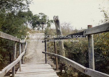
Colour Print, David Taylor, Footbridge over the Diamond Creek, Dalton Street Lane, Eltham. View heading west towards Bell Street, c.1976
The laneway past Skipper's house, an extension of Dalton Street on the western side of Main Road, has long been a regular route for Eltham High School students heading to and from school. Its present day name is Wingrove Park Trail. The footbridge over the creek was regularly subjected to damage or washed away during floods. A more substantive and flood resistant footbridge has since been erected. david taylor collection, eltham, wingrove park trail, dalton street lane, dalton street footbridge -
 Eltham District Historical Society Inc
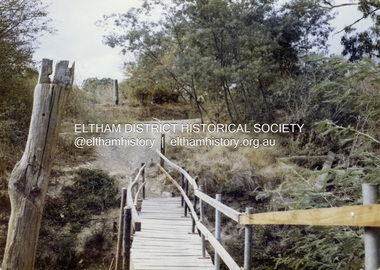
Colour Print, David Taylor, Footbridge over the Diamond Creek, Dalton Street Lane, Eltham. View heading east towards Main Road, c.1976
The laneway past Skipper's house, an extension of Dalton Street on the western side of Main Road, has long been a regular route for Eltham High School students heading to and from school. Its present day name is Wingrove Park Trail. The footbridge over the creek was regularly subjected to damage or washed away during floods. A more substantive and flood resistant footbridge has since been erected. david taylor collection, eltham, wingrove park trail, dalton street lane, dalton street footbridge -
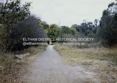
 Eltham District Historical Society Inc
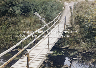
Colour Print, David Taylor, Footbridge over the Diamond Creek, Dalton Street Lane, Eltham, c.1976
The laneway past Skipper's house, an extension of Dalton Street on the western side of Main Road, has long been a regular route for Eltham High School students heading to and from school. Its present day name is Wingrove Park Trail. The footbridge over the creek was regularly subjected to damage or washed away during floods. A more substantive and flood resistant footbridge has since been erected. david taylor collection, eltham, wingrove park trail, dalton street lane, dalton street footbridge -
 Eltham District Historical Society Inc
Colour Print, David Taylor, Dalton Street Lane, Eltham, c.1976
The laneway past Skipper's house, an extension of Dalton Street on the western side of Main Road, has long been a regular route for Eltham High School students heading to and from school. Its present day name is Wingrove Park Trail. The footbridge over the creek was regularly subjected to damage or washed away during floods. A more substantive and flood resistant footbridge has since been erected. david taylor collection, eltham, wingrove park trail, dalton street lane, dalton street footbridge -
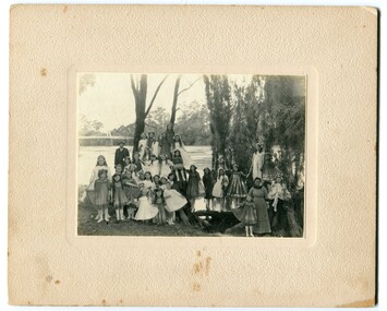 Orbost & District Historical Society
black and white photograph, 1920s
The bridge shown in the background was built in the 1920s as a road and rail bridge, and was partly washed away by flood waters in 1934. There is no known history of this item.This photograph is a contemporary record of rural life in Orbost in the early 20th century.A black / white photograph of a group of young girls dressed up and posing on the banks of a river. On the left hand side of the photograph is an older man and on the right is an older lady. In the background is a bridge - the first Snowy River bridge. The photograph is on a cream coloured buff card. orbost snowy-river -
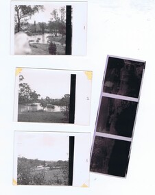 Greensborough Historical Society
Photographs and Letter, Greensborough 1960s, 1960s
Taken during a flood in the late 1960s, showing parts of both old and new bridge across the Plenty River, kiosk and Fitton house.Three photographs, with negatives and covering letter from Tony Fitton, with handwritten descriptive lettergreensborough, plenty river greensborough, fitton family -
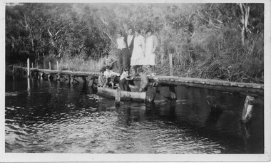 Halls Gap & Grampians Historical Society
Photograph - B/W, C 1933
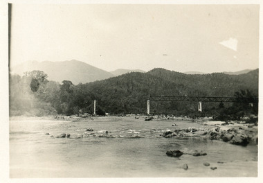
The photo shows the Wannon River in flood. Augustus (Gus) Knight built the footbridge. The boat was constructed using kerosene tins or honey tins.Photo shows five adults, four standing and one squatting, on a foot bridge. There are four children in front of them in a boat.structures, bridges -
Clunes Museum
Document, TALBOT - CLUNES SHIRE, MUNICIPAL EMERGENCY MANAGEMENT PLAN - SHIRE OF TALBOT AND CLUNES (DRAFT)
THIS PLAN HAS BEEN PREPARED AT THE DIRECTION OF THE COUNCIL OF THE SHIRE OF TALBOT & CLUNES...DOCUMENTS COLLATED IN A GREEN PLASTIC BINDER WITH A CLEAR PLASTIC COVER (UNDATED)non-fictionTHIS PLAN HAS BEEN PREPARED AT THE DIRECTION OF THE COUNCIL OF THE SHIRE OF TALBOT & CLUNES...local history, government, local government, council, essential services -
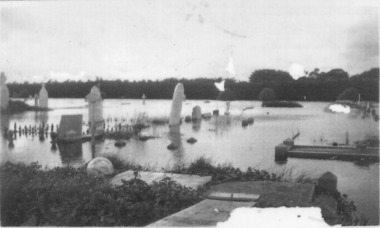 Port Fairy Historical Society Museum and Archives
Photograph
1946 was the year of the biggest flood experienced in Port Fairy. This photograph shows evidence of the inundation at the Port Fairy Cemetery situated at the West of the townBlack and white photograph of headstones surrounded by waterflood, river, 1946, headstone -
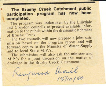 Wonga Park Community Cottage History Group
Newspaper (Item) - Photocopy Newspaper Cutting, Brushy Creek Catchment Ringwood Mail 15/10/1980
Discussion by City of Croydon and Shire of Lillydale re matter of drainage in Brushy Creek Catchment later resulting in flood retainment scheme and levy -
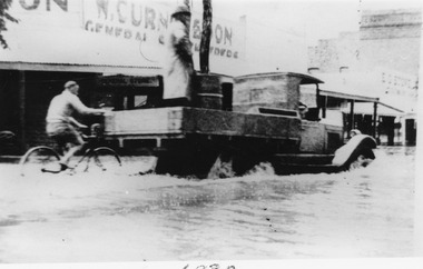 Charlton Golden Grains Museum Inc
Photograph
Flooded High Street with Ute driving through. A person on a bike holds onto the Ute tray. The store in the background is W. Curnow and sons. Black and white photograph unframed.flood, charlton, high street, w. curnow & son -
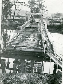 Orbost & District Historical Society
black and white photograph, 1971
This photograph shows the second major bridge across the Snowy River at Orbost. The current Snowy River bridge is the fourth to provide a crossing to the township of Orbost. The first, in 1891, lasted just two years before it succumbed to flood waters. The bridge in this photograph was built in the 1920s as a road and rail bridge, and was again partly washed away by flood waters in 1934. After the end of the first World War the Victorian Railways considered an extension of the railhead across the river at Orbost, and in 1922 a new timber and steel girder structure, a joint Country Roads Board — Victorian Railways venture, was built and completed at a cost of £41,000 (the steel girders came from the Flinders Street viaduct reconstruction). Subsequently it was decided not to take the railway across the river, and the bridge was only used by road traffic. It was severely battered by floods during its life. and after the devastating 1971 floods was eventually replaced by the current bridge in 1975. (info from Newletter 54N by John Phillips)This is a pictorial record of the flood damage in 1971 when part of the Snowy River Bridge was washed away.A black / white photograph of a bridge which has been damaged by floodwaters. It shows one end has been washed away.orbost-snowy-river-bridge-1971 floods-orbost-1971 -
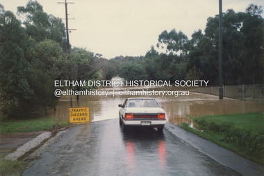
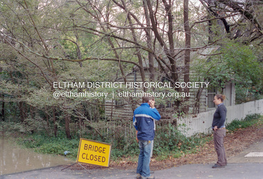
 Eltham District Historical Society Inc
Photograph - Digital Photograph, Jim Connor, Brougham Street Bridge, Eltham in flood, 13 Nov 2004
... floods ...brougham street bridge, diamond creek (creek), floods, floodwater, eltham leisure centre -
 Eltham District Historical Society Inc
Photograph, Graeme Hardiman, Diamond Creek in flood, Antoinette Boulevard, Eltham, 6 June 1989
... floods ...antoinette boulevard, diamond creek (creek), eltham, floods, floodwater -
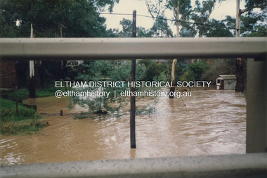 Eltham District Historical Society Inc
Photograph, Graeme Hardiman, Diamond Creek in flood, Antoinette Boulevard, Eltham, 6 June 1989
... floods ...antoinette boulevard, diamond creek (creek), eltham, floods, floodwater -
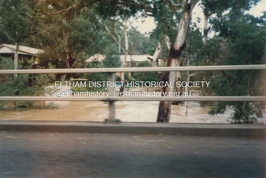
 Eltham District Historical Society Inc
Photograph, Graeme Hardiman, Diamond Creek in flood, Brougham Street, Eltham, 6 June 1989
... floods ...diamond creek (creek), eltham, floods, floodwater, brougham steet -
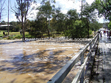
 Eltham District Historical Society Inc
Negative - Photograph, Diamond Creek floodwaters near Jarrold Cottage opposite Dalton Street, Eltham, February 2005
... floods ...Roll of 35mm colour negative film, 7 stripsKodak GC400-8diamond creek, eltham, floods, dalton street, jarrold cottage