Showing 1025 items
matching heritage site
-
 Ballarat Heritage Services
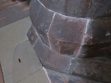
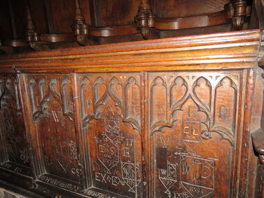
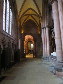
Photograph - Colour, Mason's Marks, Carlisle Cathedral 27 October 2016
Carlisle and its cathedral. This cathedral church, which has stood on this site for over 800 years has a great story to tell. It is a story that can be traced back further still, to an even earlier church of the 7th century AD. Archaeological excavations on this site have taken the story back to Roman times. Today the dean and canons and other cathedral staff ensure that the worship of God remains the main work of this cathedral, while long-standing traditions of music, hospitality and education are also maintained. The story of this place is not so much about buildings, but about people. The buildings remain as evidence of the lives of people who lived and worked here and of what they believed and achieved. Until 1540 a community of Augustinian canons served the cathedral. They lived highly organized lives in monastic buildings suited to their needs. As canons rather than monks, they were freer to undertake pastoral and educational work. carlisle, cathedral, stonemasons, mason's marks -
 Ballarat Heritage Services
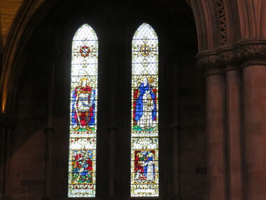
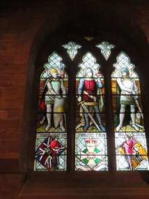
Photograph - Colour, Stained glass windows, Carlisle Cathedral 27 October 2016
Carlisle and its cathedral. This cathedral church, which has stood on this site for over 800 years has a great story to tell. It is a story that can be traced back further still, to an even earlier church of the 7th century AD. Archaeological excavations on this site have taken the story back to Roman times. Today the dean and canons and other cathedral staff ensure that the worship of God remains the main work of this cathedral, while long-standing traditions of music, hospitality and education are also maintained. The story of this place is not so much about buildings, but about people. The buildings remain as evidence of the lives of people who lived and worked here and of what they believed and achieved. Until 1540 a community of Augustinian canons served the cathedral. They lived highly organized lives in monastic buildings suited to their needs. As canons rather than monks, they were freer to undertake pastoral and educational work. carlisle, cathedral, stonemasons, mason's marks -
 Ballarat Heritage Services
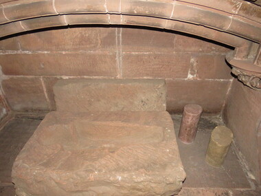
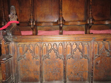
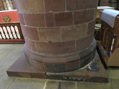
Photograph - Colour, Stonework, Carlisle Cathedral 27 October 2016
Carlisle and its cathedral. This cathedral church, which has stood on this site for over 800 years has a great story to tell. It is a story that can be traced back further still, to an even earlier church of the 7th century AD. Archaeological excavations on this site have taken the story back to Roman times. Today the dean and canons and other cathedral staff ensure that the worship of God remains the main work of this cathedral, while long-standing traditions of music, hospitality and education are also maintained. The story of this place is not so much about buildings, but about people. The buildings remain as evidence of the lives of people who lived and worked here and of what they believed and achieved. Until 1540 a community of Augustinian canons served the cathedral. They lived highly organized lives in monastic buildings suited to their needs. As canons rather than monks, they were freer to undertake pastoral and educational work. carlisle, cathedral, stonemasons, mason's marks -
 Ballarat Heritage Services
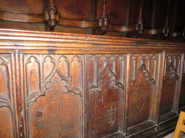
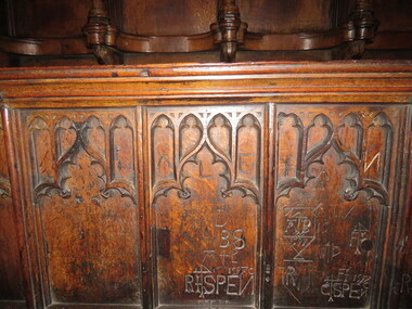
Photograph - Colour, Graffiti, Carlisle Cathedral 27 October 2016
Carlisle and its cathedral. This cathedral church, which has stood on this site for over 800 years has a great story to tell. It is a story that can be traced back further still, to an even earlier church of the 7th century AD. Archaeological excavations on this site have taken the story back to Roman times. Today the dean and canons and other cathedral staff ensure that the worship of God remains the main work of this cathedral, while long-standing traditions of music, hospitality and education are also maintained. The story of this place is not so much about buildings, but about people. The buildings remain as evidence of the lives of people who lived and worked here and of what they believed and achieved. Until 1540 a community of Augustinian canons served the cathedral. They lived highly organized lives in monastic buildings suited to their needs. As canons rather than monks, they were freer to undertake pastoral and educational work. carlisle, cathedral, stonemasons, mason's marks -
 Ballarat Heritage Services
Photograph - Colour, Graffiti, Carlisle Cathedral (made 1500-1600)
Carlisle and its cathedral. This cathedral church, which has stood on this site for over 800 years has a great story to tell. It is a story that can be traced back further still, to an even earlier church of the 7th century AD. Archaeological excavations on this site have taken the story back to Roman times. Today the dean and canons and other cathedral staff ensure that the worship of God remains the main work of this cathedral, while long-standing traditions of music, hospitality and education are also maintained. The story of this place is not so much about buildings, but about people. The buildings remain as evidence of the lives of people who lived and worked here and of what they believed and achieved. Until 1540 a community of Augustinian canons served the cathedral. They lived highly organized lives in monastic buildings suited to their needs. As canons rather than monks, they were freer to undertake pastoral and educational work. Colour photograph of graffiti in a church.carlisle, cathedral, stonemasons, mason's marks, graffiti -
 Ballarat Heritage Services
Photograph - Colour, Stonework, Carlisle Cathedral made 1500-1600
Carlisle and its cathedral. This cathedral church, which has stood on this site for over 800 years has a great story to tell. It is a story that can be traced back further still, to an even earlier church of the 7th century AD. Archaeological excavations on this site have taken the story back to Roman times. Today the dean and canons and other cathedral staff ensure that the worship of God remains the main work of this cathedral, while long-standing traditions of music, hospitality and education are also maintained. The story of this place is not so much about buildings, but about people. The buildings remain as evidence of the lives of people who lived and worked here and of what they believed and achieved. Until 1540 a community of Augustinian canons served the cathedral. They lived highly organized lives in monastic buildings suited to their needs. As canons rather than monks, they were freer to undertake pastoral and educational work. carlisle, cathedral, stonemasons, mason's marks -
 Ballarat Heritage Services
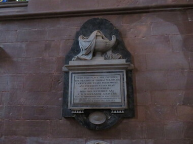
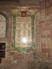
Photograph - Colour, Plaque for Border Regiment, Carlisle Cathedral
Carlisle and its cathedral. This cathedral church, which has stood on this site for over 800 years has a great story to tell. It is a story that can be traced back further still, to an even earlier church of the 7th century AD. Archaeological excavations on this site have taken the story back to Roman times. Today the dean and canons and other cathedral staff ensure that the worship of God remains the main work of this cathedral, while long-standing traditions of music, hospitality and education are also maintained. The story of this place is not so much about buildings, but about people. The buildings remain as evidence of the lives of people who lived and worked here and of what they believed and achieved. Until 1540 a community of Augustinian canons served the cathedral. They lived highly organized lives in monastic buildings suited to their needs. As canons rather than monks, they were freer to undertake pastoral and educational work. carlisle, cathedral, stonemasons, mason's marks -
 Ballarat Heritage Services
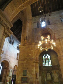
Photograph - Photograph - Colour, Stained glass window, Carlisle Cathedral
Carlisle and its cathedral. This cathedral church, which has stood on this site for over 800 years has a great story to tell. It is a story that can be traced back further still, to an even earlier church of the 7th century AD. Archaeological excavations on this site have taken the story back to Roman times. Today the dean and canons and other cathedral staff ensure that the worship of God remains the main work of this cathedral, while long-standing traditions of music, hospitality and education are also maintained. The story of this place is not so much about buildings, but about people. The buildings remain as evidence of the lives of people who lived and worked here and of what they believed and achieved. Until 1540 a community of Augustinian canons served the cathedral. They lived highly organized lives in monastic buildings suited to their needs. As canons rather than monks, they were freer to undertake pastoral and educational work. carlisle, cathedral, stonemasons, mason's marks -
 Ballarat Heritage Services
Photograph - Colour, Old Sarum, England, 2017, 01 November 2016
William the Conqueror inherited Old Sarum from the last Saxon king of England. It was an ideal site for a royal castle. It was here in 1070 that William paid off his army after a long and bitter campaign in northern England. It was here in 1086 that he called together all the major landholders in England so they could swear allegiance to him. It was a crucial moment. The Domesday Book was being written, a threatened Viking invasion had only just been averted and William's eldest son was in armed rebellion. Old Sarum was an important place where this Norman king of England held power. In 1794 the Ordnance Survey set out to check the accuracy of the first mapping of Southern England, which had begun ten years earlier. From a point just below Old Sarum Lieutenant William Mudge laid out a base-line 36,574 feet (11,253 metres) long. From each end of the line the positions of distant places were plotted using a huge theodolite made in 1791 by Jesse Ramsden. The accuracy of the process, which was repeated all over England, depended on Jesse Ramsden's craftsmanship and on William Mudge's surveying skill in setting out this first base-line from Old Sarum. The nearer end of Mudge's line is marked by an inscribed stone beside the modern A345 at Old Sarum. ordnance survey, william mudge, jesse ramsden, william the conqueror, old sarum, saxon, 1086, england -
 Ballarat Heritage Services
Photograph - Photograph - Colour, Old Sarum, England, 2016, 01/11/2016
William the Conqueror inherited Old Sarum from the last Saxon king of England. It was an ideal site for a royal castle. It was here in 1070 that William paid off his army after a long and bitter campaign in northern England. It was here in 1086 that he called together all the major landholders in England so they could swear allegiance to him. It was a crucial moment. The Domesday Book was being written, a threatened Viking invasion had only just been averted and William's eldest son was in armed rebellion. Old Sarum was an important place where this Norman king of England held power. In 1794 the Ordnance Survey set out to check the accuracy of the first mapping of Southern England, which had begun ten years earlier. From a point just below Old Sarum Lieutenant William Mudge laid out a base-line 36,574 feet (11,253 metres) long. From each end of the line the positions of distant places were plotted using a huge theodolite made in 1791 by Jesse Ramsden. The accuracy of the process, which was repeated all over England, depended on Jesse Ramsden's craftsmanship and on William Mudge's surveying skill in setting out this first base-line from Old Sarum. The nearer end of Mudge's line is marked by an inscribed stone beside the modern A345 at Old Sarum. Colour photograph of Old Sarum, England.ordnance survey, william mudge, jesse ramsden, william the conqueror, old sarum, saxon, 1086, england -
 Ballarat Heritage Services
Photograph - Colour, Earth Banks, Old Sarum, England, 01 November 2016
William the Conqueror inherited Old Sarum from the last Saxon king of England. It was an ideal site for a royal castle. It was here in 1070 that William paid off his army after a long and bitter campaign in northern England. It was here in 1086 that he called together all the major landholders in England so they could swear allegiance to him. It was a crucial moment. The Domesday Book was being written, a threatened Viking invasion had only just been averted and William's eldest son was in armed rebellion. Old Sarum was an important place where this Norman king of England held power. In 1794 the Ordnance Survey set out to check the accuracy of the first mapping of Southern England, which had begun ten years earlier. From a point just below Old Sarum Lieutenant William Mudge laid out a base-line 36,574 feet (11,253 metres) long. From each end of the line the positions of distant places were plotted using a huge theodolite made in 1791 by Jesse Ramsden. The accuracy of the process, which was repeated all over England, depended on Jesse Ramsden's craftsmanship and on William Mudge's surveying skill in setting out this first base-line from Old Sarum. The nearer end of Mudge's line is marked by an inscribed stone beside the modern A345 at Old Sarum. ordnance survey, william mudge, jesse ramsden, william the conqueror, old sarum, saxon, 1086, england -
 Ballarat Heritage Services
Photograph - Colour, Dorothy Wickham, Earth Banks, Old Sarum, England, 2016, 01 November 2016
William the Conqueror inherited Old Sarum from the last Saxon king of England. It was an ideal site for a royal castle. It was here in 1070 that William paid off his army after a long and bitter campaign in northern England. It was here in 1086 that he called together all the major landholders in England so they could swear allegiance to him. It was a crucial moment. The Domesday Book was being written, a threatened Viking invasion had only just been averted and William's eldest son was in armed rebellion. Old Sarum was an important place where this Norman king of England held power. In 1794 the Ordnance Survey set out to check the accuracy of the first mapping of Southern England, which had begun ten years earlier. From a point just below Old Sarum Lieutenant William Mudge laid out a base-line 36,574 feet (11,253 metres) long. From each end of the line the positions of distant places were plotted using a huge theodolite made in 1791 by Jesse Ramsden. The accuracy of the process, which was repeated all over England, depended on Jesse Ramsden's craftsmanship and on William Mudge's surveying skill in setting out this first base-line from Old Sarum. The nearer end of Mudge's line is marked by an inscribed stone beside the modern A345 at Old Sarum. King William devised the Domesday Book, considered to be the first listing of land owners in England. Among the names is that of D'Arques, from Normandy, France. Descendants of this family later emigrated from England and settled in Victoria, Australia under the surname 'Dark'. ordnance survey, william mudge, jesse ramsden, william the conqueror, old sarum, saxon, 1086, england -
 Ballarat Heritage Services
Photograph - Colour, Earth Banks, Old Sarum, England, 2016, 01 November 2016
William the Conqueror inherited Old Sarum from the last Saxon king of England. It was an ideal site for a royal castle. It was here in 1070 that William paid off his army after a long and bitter campaign in northern England. It was here in 1086 that he called together all the major landholders in England so they could swear allegiance to him. It was a crucial moment. The Domesday Book was being written, a threatened Viking invasion had only just been averted and William's eldest son was in armed rebellion. Old Sarum was an important place where this Norman king of England held power. In 1794 the Ordnance Survey set out to check the accuracy of the first mapping of Southern England, which had begun ten years earlier. From a point just below Old Sarum Lieutenant William Mudge laid out a base-line 36,574 feet (11,253 metres) long. From each end of the line the positions of distant places were plotted using a huge theodolite made in 1791 by Jesse Ramsden. The accuracy of the process, which was repeated all over England, depended on Jesse Ramsden's craftsmanship and on William Mudge's surveying skill in setting out this first base-line from Old Sarum. The nearer end of Mudge's line is marked by an inscribed stone beside the modern A345 at Old Sarum. ordnance survey, william mudge, jesse ramsden, william the conqueror, old sarum, saxon, 1086, england -
 Ballarat Heritage Services
Photograph - Photograph - Colour, Castle toilets, Old Sarum, England, 2016, 01/11/2016
William the Conqueror inherited Old Sarum from the last Saxon king of England. It was an ideal site for a royal castle. It was here in 1070 that William paid off his army after a long and bitter campaign in northern England. It was here in 1086 that he called together all the major landholders in England so they could swear allegiance to him. It was a crucial moment. The Domesday Book was being written, a threatened Viking invasion had only just been averted and William's eldest son was in armed rebellion. Old Sarum was an important place where this Norman king of England held power. In 1794 the Ordnance Survey set out to check the accuracy of the first mapping of Southern England, which had begun ten years earlier. From a point just below Old Sarum Lieutenant William Mudge laid out a base-line 36,574 feet (11,253 metres) long. From each end of the line the positions of distant places were plotted using a huge theodolite made in 1791 by Jesse Ramsden. The accuracy of the process, which was repeated all over England, depended on Jesse Ramsden's craftsmanship and on William Mudge's surveying skill in setting out this first base-line from Old Sarum. The nearer end of Mudge's line is marked by an inscribed stone beside the modern A345 at Old Sarum. Colour photographs of Castle toilets at Old Sarum, England. The toilets are constructed of stone. ordnance survey, william mudge, jesse ramsden, william the conqueror, old sarum, saxon, 1086, england, subjects, toilets -
 Ballarat Heritage Services
digital photographs, Manchester cathedral pamphlet, 2016
In the early middle ages the 'new town' of Manchester developed about a mile from the former Roman settlement of Castlefield. The Domesday Book (1086) records that within the Salford Hundred , Manchester had a church dedicated to St Mary. By the 13th centruy there was a stone church on the site by the de Gresle family whose crest is still used by the Manchester cathedral today. ... More information is contained within the pamphlet.4 Digital photographs, part of a pamphletmanchester, manchester cathedral, de gresle, england, domesday book -
 Ballarat Heritage Services
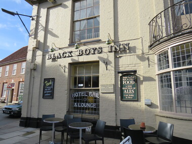
digital photographs, Inn, Aylesham, England, 2016
Black Boys Inn is in the market square of Aylesham, England. "Archaeological evidence shows that the site of the town has been occupied since prehistoric times. Aylsham is just over two miles (3 km) from a substantial Roman settlement at Brampton, linked to Venta Icenorum at Caistor St Edmund, south of Norwich, by a Roman road which can still be traced in places - that site was a bustling industrial centre with maritime links to the rest of the empire. Excavations in the 1970s provided evidence of several kilns, showing that this was an industrial centre, pottery and metal items being the main items manufactured. Aylsham is thought to have been founded around 500 AD by an Anglo Saxon thegn called Aegel, Aegel's Ham, meaning "Aegel's settlement". The town is mentioned in the Domesday Book of 1086 as Elesham and Ailesham, with a population of about 1,000. Until the 15th century, the linen and worsted industry was important here, as well as in North Walsham and Worstead and Aylsham webb or 'cloth of Aylsham' was supplied to the royal palaces of Edward II and III. John of Gaunt was lord of the manor from 1372 and Aylsham became the principal town of the Duchy of Lancaster. Although John of Gaunt probably never came to Aylsham, the townspeople enjoyed many privileges, including exemption from jury service outside the manor and from payment of certain taxes. The village sign depicts John of Gaunt. In 1519 Henry VIII granted a market on Saturdays and an annual fair to be held on 12 March, which was the eve of the feast of St Gregory the pope. Aylsham markets have always been an important feature of the town, and businesses developed to meet the needs of the town and the farming lands around it. Besides weekly markets there were cattle fairs twice a year and, in October, a hiring fair. The historic Black Boys Inn in the Market Place is one of Aylsham's oldest surviving buildings, and has been on the site since the 1650s, although the present frontage dates to between 1710 and 1720. There is a frieze of small black boys on the cornice and a good staircase and assembly room. The Black Boys was a stop for the post coach from Norwich to Cromer, had stabling for 40 horses, and employed three ostlers and four postboys. A thatched waterpump was built in 1911 at Carr's Corner in memory of John Soame by his uncle, a wealthy financier. An artesian well 170 feet (52 m) deep, its canopy is thatched in Norfolk reed. As with many of the other market towns in the county, the weaving of local cloth brought prosperity to the town in medieval times. Until the 15th century it was the manufacture of linen which was the more important, and Aylsham linens and Aylsham canvases were nationally known. From the 16th century linen manufacture declined and wool became more important, a situation that continued until the coming of the Industrial Revolution. Thereafter the principal trade of the town for the 19th century was grain and timber, together with the range of trades to be found in a town which supported local agriculture. Records show that Aylsham had markets and fairs, certainly from the 13th century. Such weekly and annual events were important for the trade that they brought. Annual horse fairs would bring many other traders to the town, and the weekly market would be the occasion for more local trade. The rights of the stallholders in the market place today date back to the rights established in medieval times." See wikipediaDigital photograph colouredinn, aylsham, england, black boys inn, market square -
 Ballarat Heritage Services
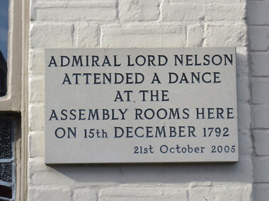
Photograph - Digital photograph, Lord Nelson Plaque, 2016
Black Boys Inn is in the market square of Aylsham, England. "Archaeological evidence shows that the site of the town has been occupied since prehistoric times. Aylsham is just over two miles (3 km) from a substantial Roman settlement at Brampton, linked to Venta Icenorum at Caistor St Edmund, south of Norwich, by a Roman road which can still be traced in places - that site was a bustling industrial centre with maritime links to the rest of the empire. Excavations in the 1970s provided evidence of several kilns, showing that this was an industrial centre, pottery and metal items being the main items manufactured. Aylsham is thought to have been founded around 500 AD by an Anglo Saxon thegn called Aegel, Aegel's Ham, meaning "Aegel's settlement". The town is mentioned in the Domesday Book of 1086 as Elesham and Ailesham, with a population of about 1,000. Until the 15th century, the linen and worsted industry was important here, as well as in North Walsham and Worstead and Aylsham webb or 'cloth of Aylsham' was supplied to the royal palaces of Edward II and III. John of Gaunt was lord of the manor from 1372 and Aylsham became the principal town of the Duchy of Lancaster. Although John of Gaunt probably never came to Aylsham, the townspeople enjoyed many privileges, including exemption from jury service outside the manor and from payment of certain taxes. The village sign depicts John of Gaunt. In 1519 Henry VIII granted a market on Saturdays and an annual fair to be held on 12 March, which was the eve of the feast of St Gregory the pope. Aylsham markets have always been an important feature of the town, and businesses developed to meet the needs of the town and the farming lands around it. Besides weekly markets there were cattle fairs twice a year and, in October, a hiring fair. The historic Black Boys Inn in the Market Place is one of Aylsham's oldest surviving buildings, and has been on the site since the 1650s, although the present frontage dates to between 1710 and 1720. There is a frieze of small black boys on the cornice and a good staircase and assembly room. The Black Boys was a stop for the post coach from Norwich to Cromer, had stabling for 40 horses, and employed three ostlers and four postboys. A thatched waterpump was built in 1911 at Carr's Corner in memory of John Soame by his uncle, a wealthy financier. An artesian well 170 feet (52 m) deep, its canopy is thatched in Norfolk reed. As with many of the other market towns in the county, the weaving of local cloth brought prosperity to the town in medieval times. Until the 15th century it was the manufacture of linen which was the more important, and Aylsham linens and Aylsham canvases were nationally known. From the 16th century linen manufacture declined and wool became more important, a situation that continued until the coming of the Industrial Revolution. Thereafter the principal trade of the town for the 19th century was grain and timber, together with the range of trades to be found in a town which supported local agriculture. Records show that Aylsham had markets and fairs, certainly from the 13th century. Such weekly and annual events were important for the trade that they brought. Annual horse fairs would bring many other traders to the town, and the weekly market would be the occasion for more local trade. The rights of the stallholders in the market place today date back to the rights established in medieval times." See wikipediaDigital photograph"Admiral Lord Nelson attended a dance at the Assembly rooms here on 15th December 1792 - 21st October 2005"aylsham, lord nelson, 1792, plaque -
 Ballarat Heritage Services
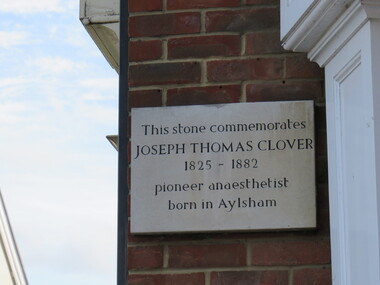
Photograph - Digital photograph, Dorothy Wickham, Plaque to Joseph Thomas Clover, ć2016
Lord Nelson plaque is in the town of Aylsham. "Archaeological evidence shows that the site of the town has been occupied since prehistoric times. Aylsham is just over two miles (3 km) from a substantial Roman settlement at Brampton, linked to Venta Icenorum at Caistor St Edmund, south of Norwich, by a Roman road which can still be traced in places - that site was a bustling industrial centre with maritime links to the rest of the empire. Excavations in the 1970s provided evidence of several kilns, showing that this was an industrial centre, pottery and metal items being the main items manufactured. Aylsham is thought to have been founded around 500 AD by an Anglo Saxon thegn called Aegel, Aegel's Ham, meaning "Aegel's settlement". The town is mentioned in the Domesday Book of 1086 as Elesham and Ailesham, with a population of about 1,000. Until the 15th century, the linen and worsted industry was important here, as well as in North Walsham and Worstead and Aylsham webb or 'cloth of Aylsham' was supplied to the royal palaces of Edward II and III. John of Gaunt was lord of the manor from 1372 and Aylsham became the principal town of the Duchy of Lancaster. Although John of Gaunt probably never came to Aylsham, the townspeople enjoyed many privileges, including exemption from jury service outside the manor and from payment of certain taxes. The village sign depicts John of Gaunt. In 1519 Henry VIII granted a market on Saturdays and an annual fair to be held on 12 March, which was the eve of the feast of St Gregory the pope. Aylsham markets have always been an important feature of the town, and businesses developed to meet the needs of the town and the farming lands around it. Besides weekly markets there were cattle fairs twice a year and, in October, a hiring fair. The historic Black Boys Inn in the Market Place is one of Aylsham's oldest surviving buildings, and has been on the site since the 1650s, although the present frontage dates to between 1710 and 1720. There is a frieze of small black boys on the cornice and a good staircase and assembly room. The Black Boys was a stop for the post coach from Norwich to Cromer, had stabling for 40 horses, and employed three ostlers and four postboys. A thatched waterpump was built in 1911 at Carr's Corner in memory of John Soame by his uncle, a wealthy financier. An artesian well 170 feet (52 m) deep, its canopy is thatched in Norfolk reed. As with many of the other market towns in the county, the weaving of local cloth brought prosperity to the town in medieval times. Until the 15th century it was the manufacture of linen which was the more important, and Aylsham linens and Aylsham canvases were nationally known. From the 16th century linen manufacture declined and wool became more important, a situation that continued until the coming of the Industrial Revolution. Thereafter the principal trade of the town for the 19th century was grain and timber, together with the range of trades to be found in a town which supported local agriculture. Records show that Aylsham had markets and fairs, certainly from the 13th century. Such weekly and annual events were important for the trade that they brought. Annual horse fairs would bring many other traders to the town, and the weekly market would be the occasion for more local trade. The rights of the stallholders in the market place today date back to the rights established in medieval times." See wikipediaDigital photograph"This stone commemorates JOSEPH THOMAS CLOVER 1825-1882 pioneer anaesthetist born in Aylsham"aylsham, joseph thomas clover, anaesthetist -
 Ballarat Heritage Services
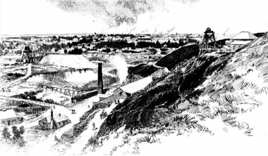
Photograph - Image - Black and White, Ballarat From Black Hill, 1888, 1888
Image of a mining site on Black Hill, with the township of Ballarat in the background. black hill, mining, poppett head, black hill flat -
 Ballarat Heritage Services
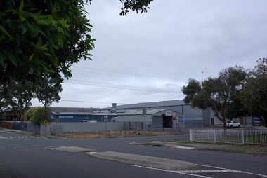
Photograph - Photograph - Colour, Industrial Buildings on the corner of Yarrowee Street and Vickers Street, Sebastopol, 2020, 07/04/2020
Colour photographs of an industrial site on the corner of Yarrowee Street and Vickers Street, Sebastopol. sebastopol, yarrowee street, sebastopol, vickers street, sebastopol