Showing 6427 items matching "housing"
-
 Greensborough Historical Society
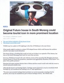
Newspaper Clipping - Digital Image, The Whittlesea Post, Futuro House Greensborough, 2017, 02/07/2017
Written in 2017, this article reports on the history of the Futuro House, now in South Morang, but previously used in Greensborough as a temporary booth for sales of land at a new housing estate called Apollo Parkways.Digital copy of newspaper clipping, black text and colour image.futuro house, apollo parkways -
 International House, The University of Melbourne
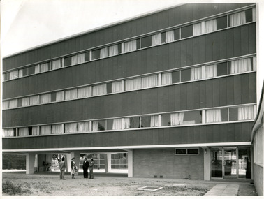
Photograph (item), Australian News and Information Bureau, Newly constructed Ian Clunies Ross building at International House Melbourne, 1957
This building was the first residential housing for the newly established International House in Melbourne, which had been in its planning stages since 1954. The building housed both domestic and international students.residential college, international house, architecture -
![Photograph - Digital image, Pioneer Children's Cemetery [Cairn], 1985_](/media/collectors/4f729f5697f83e03086015b8/items/54bb53c42162f10ca8d771ed/item-media/54bb55282162f10ca8d78724/item-fit-380x285.jpg) Greensborough Historical Society
Greensborough Historical SocietyPhotograph - Digital image, Pioneer Children's Cemetery [Cairn], 1985_
The unmarked graves of the children of two Greensborough pioneer families lie in a private cemetery on the Plenty River. Burials occurred between 1848 and 1860. This photograph shows the close proximity to housing and the Cairn for the plaque.A significant historical site in Greensborough.Digital copy of colour photograph.pioneer childrens cemetery, whatmough, partington -
 City of Moorabbin Historical Society (Operating the Box Cottage Museum)
Flyer - Smith's Estate, Highett
The train line from the city to Mordialloc was built which opened up the land for housing development. The section bounded by Peterson Street Telford Street and Highett Road is now Peterson Street Reserve.Example of the progress of the Municipality of MoorabbinAdvertising flyer for auction of real estate sales - plan of building blocks for saleSmith's Estate, Highett - J. F. Bradyhighett, real estate, highett road, hillside street (no longer exists), peterson st, frederico st, tolhurst st (no longer exists), wickham road, danson street, peterson street reserve -
 Port Melbourne Historical & Preservation Society
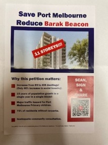
Flyer, Save Port Melbourne Reduce Barak Beacon, 2024
Flyer expresses residents concerns on proposed new increased heights and number of dwellings for the development which replace the low rise Ministry of Housing Sandridge Estate that had occupied the site since 1982.Half A4 size flyer has blue and red text on a white background and a photo of a tower block on the cover with '11storeys!!!'barak beacon, built environment - domestic -
 Robin Boyd Foundation
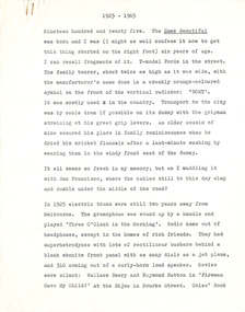
Document - Manuscript, Robin Boyd, 1925 -1965, 1965
Overview of residential architectural styles from 1925 to 1965 to celebrate the 40th anniversary of "Home Beautiful" magazine. Discussions include the future of housing technology, Californian Bungalow design and the future of the 'modern house'.Original manuscript of 'Is our frozen house design about to thaw', published in Australian Home Beautiful, Vol, 44, No. 10, October 1965, pp. 4-11.Typewritten (c copy), quarto, 23 pages. (Two copies)home beautiful, queen anne, californian bungalow, charles greenhill, walter burley griffin, harold desbrowe-annear, home beautiful, modernism, robin boyd, manuscript -
 Ringwood and District Historical Society
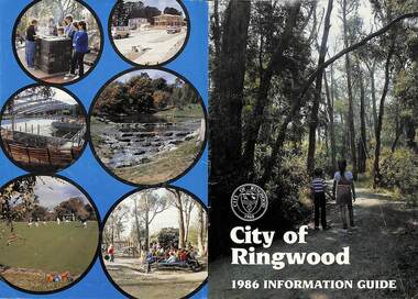
Booklet, City of Ringwood 1986 Information Guide, 1986
Community information booklet issued by City of Ringwood for 1986 - covering the facilities and activities of the Ringwood Council and other local organisations and associations. Cover photographs: Front - Wombalano Park; Back L-R - Barbecue at Ringwood Lake, Housing construction at Ringwood, Enclosing swimming centre, Water cascade at rear of Ringwood Lake, Croquet at Jubilee Park, Playground at Ringwood Lake.CONTENTS: (page no.) After School Care Programme 30 & 31 Amalgamations 16 Aquatic Centre 14 & 15 Building Information 22 By-Law and Traffic Regulations 23 Chief Executive Message I0 Churches 38 Civic Centre 4 Committees of Council 5 Community Plan 12 & 13 Construction Work 34 Council Meeting Dates 4 Council Representatives 8 Councillors 6 & 7 Disabled Persons Facilities 41 Eastern Corridor Road Action Plan 17 Emergency Telephone Nos. 63 European Wasps 27 Family Day Care 30 Finances 18 Golf Course 22 Health 20 Historical Research Group 44 Home Help 33 Hospitals 45 Immunisations 2 i Incinerators 34 Infant Welfare Centres 45 Knaith Road Child Care Centre 30&31 Library 24 Local Area Traffic Management 17 Management Executive 11 Mayoral Message – Cr. W.R. (Bill) Wilkins, J.P. 3 Meals on Wheels 32 Members of Parliament 9 North Ringwood Senior Citizens 29 Parks for People 28 Playgroups 49 Pre-Schools 50 Rates 19 Rubbish — See Waste Ringwood District Centre 16 Schools 52 Swimming Pool — See Aquatic Centre 14 & 15 Waste 26rinx -
 Bendigo Military Museum
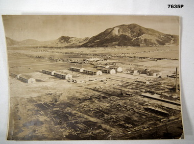
Photograph - RAAF BARRACKS BOFU JAPAN, RAAF, 1946
Item is part of the BCOF Association Collection, refer Cat No 7625This is a large black and white photo. In the background are mountains. On right side of the photo, are some factories with tall chimneys. The middle ground is flat. It shows housing alongside roads. The foreground shows 10 major double storey buildings and three rows of single storey buildings The foreground, left bottom of the picture shows darkened devastated area. A solo tall chimney is on the right side.On rear - “81 fighter..... Occupation Forces. RAAF Camp (Barracks) Bofu, Japan 1946. This was previously a camp for Kamakazi pilots”ww2, bcof, japan -
 Glenelg Shire Council Cultural Collection
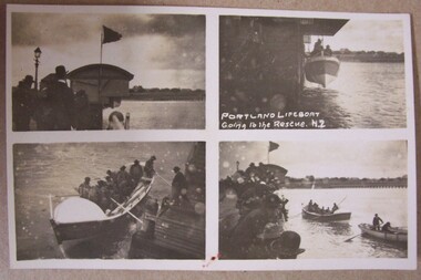
Photograph - Photograph - Portland Lifeboat Going to the Rescue, Kodac, n.d
Displayed at History House.Small series of 4 photos - Width is 13.4cm 1. Shows building housing lifeboat. Flag flying. Group of people. Gas lamp. 2. Lifeboat being lowered - Crew on board. 3. Lifeboat in water - men wearing life jacket - using oars to push off - man on pier. 4. Lifeboat and 1 other boat under way. Crown on pier.Front: Portland Lifeboat. Going to the Rescue (NZ) ??? Back: Postcard. To Jean with love Uncle Will -
 Kiewa Valley Historical Society
Ash Tray Pocket
This flip top pocket aluminium ash tray was at the beginning of the social "cleaning up" of cigarette ash and related products. This cigarette waste container was for those occasions when it was polite not to throw the cigarette ash and used up cigarettes "buts" on the ground, or if working in any rural area during a dry fire prone season, when discarding burning cigarette waste could set up a severe "bush" fire. It was also at the beginning of an intensive look at the affects of smoking upon the health of users. Later in the 1900s was a time when medical evidence supported a ground swell of the anti smoking movement which resulted in further restrictions of the use cigarette smoking in public places. Before the anti cigarette smoking revolution, it was both fashionable and manly to either roll your own cigarette or open up a packet of "tailor made's". In the rural and man's man environment the roll your own provided a visual acknowledgement that the user was "true blue" Aussie male and not a city boy. The cycle of use of cigarettes has drastically changed from when this item was first used. Today's society (post 2000) has produced a ground swell of government and non government organisations whose aim is provide a cigarette "ash" free environment and society. This is highlighted in the beginning of the 2000 millennium by a cigarette "Free" Australia campaign, and the pocket flip top personal ash tray as a practical solution for butt litter disposal.This light weight aluminium pocket ash tray not only was used when social graces required it to, but also provided a container for any unfinished cigarettes or stogies (cheap half used cigars). In rural areas (open fresh air countryside), where time was always made available for the "smoko" (Australian rest period), at any time, especially after some hard physical work, the ability to have a self contained ashing apparatus, not to offend the gentler folk, was a pre-requisite . The rural environment, in the days of these cigarette ash containers,was one which could range from harsh and unforgiving to mild and relaxing. Smoking could be enjoyed anywhere and at any time without too much "fussing" around. This ash tray was mobile, convenient, unobtrusive and regarded by the user as being considerate to those around. It also eliminated the tell tale evidence that the "no smoking" signs had been ignored. The Kiewa Valley was like many rural ares that found it hard for smokers to come to grips with a governmental "non smoking policy" to indoor recreational and other "confined space" environments. The covered lid reduces odors and eliminates ashes from being blown around.Aluminium round container with a lid. The opening lid is spring loaded, hinged top, circular and fixed by a clasp, pop- riveted (4) onto the main housing. Opposite the hinge the lid is held closed by a small metal ball fitting tightly to the top wall of the container. The lid is opened by the use of a fingernail positioned at junction of lid to body. This edge is bevelled to allow access.personal effects, tobacco waste products, smoking accessories, tobacco -
 Bendigo Historical Society Inc.
Document - NORMAN OLIVER COLLECTION: THE MAYOR SPEAKS 5 JUNE 1965
The Norman Oliver collection. Norman Oliver was three times Mayor of Bendigo - 1950-51, 1964-65, 1970-71. Three pages of typed notes titled 'The Mayor Speaks June 5th 1965. Topics include: the Bendigo East Charity Club, the visit of Mr Tan Hoo Fong from Indonesia, and the housing problem in Bendigo and its effect on industrial development,bendigo, council, report, norman joseph oliver , councillor norman oliver. mayor of bendigo. bendigo east charity club. -
 Port Melbourne Historical & Preservation Society
Film - CD-ROM, PMHPS Meeting, Presentation, Gems found at the Public Records Office Victoria, Steve Tserkezidis, 26 Jan 2015
PMHPS meeting 26.01.2015 Powerpoint presentation by Steve Tserkezidis on "gems found at the Public Records Office Victoria". Principally containing images and plans involving State Bank housing estates at Garden City, Fishermen's bend and the Dunstan estate. Images of the State Savings Bank building and Riall print have been separately extracted and entered on the database as cat nos 3468 to 3471 built environment - domestic, built environment - commercial, steve tserkezidis, state savings bank of victoria -
Port Melbourne Historical & Preservation Society
Book - Port Melbourne Council, Sanitary Inspectors Report Book, J L Cousland, Inspector et al, 1944 - 1955
Sanitary Inspector's Reports to Port Melbourne Council 1944-1955. Detailing testing and immunisation programmes, mass x-ray, vaccination for smallpox, cleansing station opened, poor conditions in emergency housing areas, Lands Dept neglect of Crown land, rubbish dumped in air raid shelters, advice sought re football and cricket played on streets, wood for pensionersLabel on spine illegible; 'Inspectors reports' inside covertransport - motor vehicles, local government - city of port melbourne, environmental issues, health - general health, business and traders, industry, nightsoil, built environment, fishermans bend, livestock, engineering - canals and drainage, james llewellyn cousland, b e w aitken, harley grover, dr merrilees, mr hepburn -
 Tennis Australia
Smoking accessory, Circa 1915
(1/2) A silver & amber cigaretter holder (Austrian), with relief of scene on silver section depicting a male figure holding a tennis racquet. No makers marks. (2/2) Custom case for housing part 1; made of wood, leather and lined with velvet and cloth. Printed in gold ink on cloth inside lid: 'ECHT SILBER & BERNSTEIN'. Materials: Silver/Metal, Ambertennis -
 Bendigo Historical Society Inc.
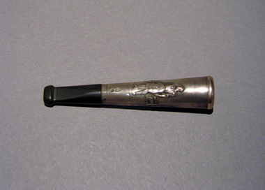
Document - LONG GULLY HISTORY GROUP COLLECTION: $6M GULLY PLAN
BHS CollectionPhotocopy of the front page of the Bendigo Advertiser Friday August 20, 1999. The article titled $6m Gully plan by Linda Barrow mentions a building plan for the area. It has a photo of Ron Best MLC and Housing Minister Ann Henderson on a tour of Long Gully. There is a small article about Phil White, The Herald Sun/Monash University Teacher of the Year Award.bendigo, history, long gully history group, the long gully history group - $6m gully plan, bendigo advertiser20/8/1999, ron best, ann henderson, jacquelene hunt, phil white, golden square secondary college, herald sun, monash university, graeme fryar, racv, ashmans, linda barrow -
 Mission to Seafarers Victoria
Photograph - Photograph, Sepia, Mr and Mrs Gurney Goldsmith, Disabled French Barque: Towing up the Yarra from Monomeith Gardens Newport, 1906
Monomeith was the house of Major and Mrs A. Morton Begg, located 67 the Strand, in Newport (housing the Westbourne Grammar School, Williamstown Campus, since it was leased from the Harbour Trust in 1956 then purchased by the school in 1972)Small monochrome photograph, view of ships from a parkHandwritten in pencil on verso: 83 (?) and a 3 in bottom right cornermonomeith, newport, morton begg, french, barque, towing, yarra river -
 Robin Boyd Foundation
Document, Plan
Plan of Eastlakes development NSW (north of Botany) with home units, housing commission, shopping centre and public reserve between Gardeners RD, Universal Street, Grafton Street, Florence Street and Maloney Street.Photocopy, double page taped on reverse. Handwritten and typewritten. -
 Port Melbourne Historical & Preservation Society
Photograph - Original gate post, Excelsior Hall, Port Melbourne, Gary Spivak, 2000
Taken by Gary Spivak, an officer of the City of Port Phillip involved with the reconstruction of heritage buildings to create low cost housing. this project was under his direction. This gatepost was preserved in the reconstruction, one of the few portions that were.B&W photos of Excelsior Hall 2003, prior to redevelopment into units 07 - Original gate postbuilt environment - civic, town planning, heritage, excelsior hall, rsl, returned services league -
 Eltham District Historical Society Inc
Photograph, R.J. Manuell, Briar Hill, c.1964
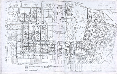
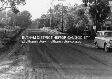
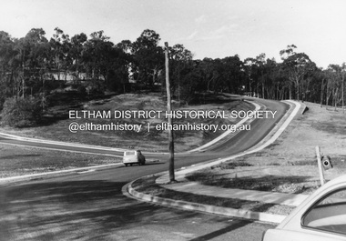
View of Squires land which was subdivided for housing - two parts Woodland Crest higher part off Woodland Grove and Calrossi Avenue, Briar Hill showing new roads with curb and channelling and footpaths. No date.Black and white photograph printed with white bordersVerso: COO2briar hill, real estate, woodland grove, squires, roads -
 Eltham District Historical Society Inc
Photograph, R.J. Manuell, Briar Hill, c.1964
View of Squires land which was subdivided for housing - two parts Woodland Crest higher part off Woodland Grove and Calrossi Avenue, Briar Hill showing new roads with curb and channelling and footpaths. No date.Black and white photograph printed with white bordersVerso: COO2briar hill, real estate, woodland grove, squires, roads -
 City of Ballarat Libraries
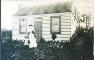
Photograph, 616 Ascot Street South, Ballarat circa 1890
616 Ascot Street South was a shingled roof miners cottage. Mrs E. Saw and her son are pictured.ascot street south, ballarat, house, housing, e. saw, ballarat central -
 Phillip Island and District Historical Society Inc.
Booklet, Cowes McRae Beach Estate, 1960s
This land was owned by the McRae family, whose wife was a Justice. Hence the street names of McRae and Justice. The weatherboard family home [ originally a guest house called Glen Isle] was at the end of the current Justice Road. The estate was created in the mid 1960s. The house was put on skids and dragged by two tractors and a bulldozer to 364 Church Street while the family home was built at 368 Church Street, Cowes.[ Source Sandra Rocotas, nee McCrae. Facebook Community Noticeboard 5/2/2023. Permission given to use information and photos ] Estate was sold by Rogan Real Estate.HistoricalColoured A4 brochure describing the McRae Beach Estate, including plan of streets and location on Island, photos and description of the Island. Sold by Rogan Real Estate.Cowes McRae Beach Estate - Right in the heart of things .Phillip Island - The Loveliest Isle on Earthhousing, justice family, mcrae family, cowes west, rogan real estate cowes phillip island, glen isla -
 Chelsea & District Historical Society Inc
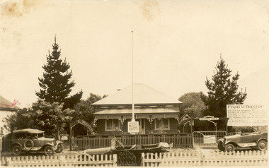
Photograph - Thames Promenade, Chelsea, Mr Baxter's house, 1916-1920
Black and white photo of a house in Thames Avenue, Chelsea. The weatherboard house, with a picket fence, has a flagpole with a sign advertising for "Fred. W. Baxter New Zealand Insurance Company" in the front garden. A large billboard is on the right advertising the various business that Mr Baxter ran. In front of the house, on the street, there are three parked cars.Fred. W. Baxter Agent NEW ZEALAND INSURANCE COMPANY Co. OXYMEL OIL AND PAINT COMPANY HIGH GRADE PAINTS CYCLONE PTY LTD METAL GATES AND FENCES COLORO PTY LTD ALEX. STURROCK & SONS TIMBER MERCHANTS AND IMPORTERS RENOWN CARSthames promenade, chelsea, mr fred. w. baxter, businesses, housing, cars -
 Bendigo Military Museum
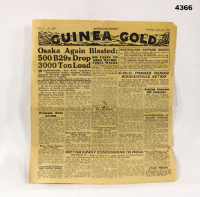
Newspaper - NEWSPAPER, 1945, Guinea Gold, 16.6.1945
Some items include, B 29 raids over Osaka, General Blamey in Bougainville, British concessions to India, post war housing plan, Soviet Govt announces trial of Polish leaders, the races, civilian news.Newspaper, Guinea Gold, yellowed, 4 pages, all printing in Black, no illustrations or photos.ON Front, “Vol 3 No 209 - Sat June 16 1945”guinea gold, newspapers, 1945 -
 City of Moorabbin Historical Society (Operating the Box Cottage Museum)
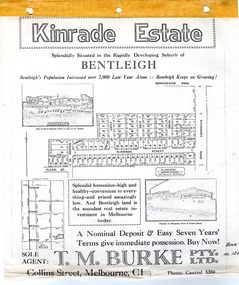
Flyer - Kinrade Estate, Bentleigh East
Kinrade Estate was not subdivided as shown in flyer. The land was purchased by Cyclone in 1950. Cyclone built a factory which manufactured wire material. This factory was closed in XXXX and a development firm purchased the land and subdivided the land into housing blocks.Example of the progress of the Municipality of MoorabbinAdvertising flyer for auction of real estate sales - plan of building blocks for saleleary avenue, charles street, peter leary, john joseph kinrade, tucker road, east boundary road, clover estate, kinrade estate, bentleigh, cyclone company, ardena court, bentleigh east -
 Lake Bolac & District Historical Society
Colour photograph, Lake Bolac Flax Mill, 1960
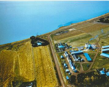
Aerial view of the Lake Bolac Flax Mill, circa 1960. Note the pump housing in front of Guy Rance's home, the polluted water entering the lake from the pipeline and the stooks of flax to the left of the road opposite the Mill.lake bolac, flax mill, 1960, rance -
 Hume City Civic Collection
Photograph, early 1980s
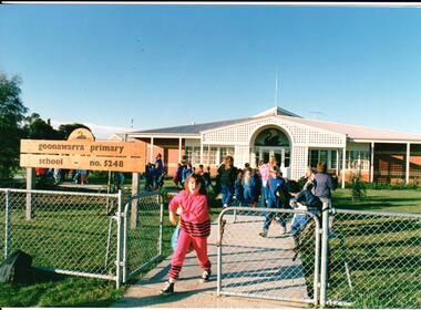
Goonawarra Primary School was opened in the early 1980s to accommodate children who were living in the Goonawarra Housing Estate. Prior to development this area was known as Goonawarra Farm and John McMahon grazed his dairy cattle on the land.A coloured photograph of the Goonawarra Primary School and main gate with school children leaving the grounds. A girl dressed in a pink tracksuit is at the gate.state education, schools, goonawarra primary school, goonawarra housing estate, goonawarra farm, ministry of education, george evans collection -
 Hume City Civic Collection
Photograph, early 1980s
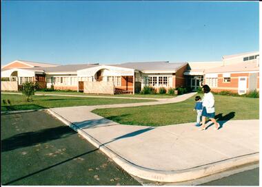
Goonawarra Primary School was opened in the early 1980s to accommodate children who were living in the Goonawarra Housing Estate. Prior to development this area was known as Goonawarra Farm and John McMahon grazed his dairy cattle on the land.A coloured photograph of the recently completed Goonawarra Primary School. A lady and little boy are walking along the footpath in front of the building. There is an expanse of lawn between the path and the building.state education, schools, goonawarra primary school, goonawarra housing estate, goonawarra farm, ministry of education, george evans collection -
 Whitehorse Historical Society Inc.
Photograph - Black and white photo, Winlaton Youth Training Centre
A house on the site was originally owned by successful businessman , Joseph Tweedle before being sold to the government. For many years it was the Winlaton Training Centre for girls. When the institution was closed the buildings were demolished and the land subdivided for housing.Four girls standing in the grounds of Winlaton outside a building.winlaton youth training centre, nunawading -
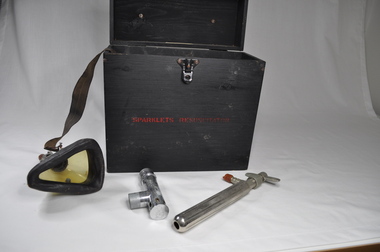 Kiewa Valley Historical Society
Portable Resuscitator Electric Therapy Unit
A shock of different voltages was delivered to a person using the two metal handles or two heavy soft wire combs (missing but known of) were moved across the skin. Perhaps this was an early TENS Unit. The unit came to the donor's grandfather (Roy F. Leibig - Chief Electrical Inspector of the Brunswick (Melbourne) Electric Supply) for repair and returned to his keeping once it had become obsolete (upgraded by newer machine). Donor often helped his Pa repair electrical equipment.Historical: The Resuscitator or Electric Therapy Unit was used in hospitals, possibly Mental hospitals. Provenance: The donor worked at Mt Beauty in the Kiewa Hydro Electric Scheme with the State Electric Commission of Victoria as an electrician. Black wooden smooth box with clip fastener which is screwed on - 3 screws for the base and 2 for the lid. On top of the box is a leather strap for the handle fastened by steel screwed into the box. Inside: A mask with attached strap. Tap fitting loosely into steel box. Metal cylinders and a Cardboard box. A wooden lockable case, housing electrical equipment suitable for issuing high voltage shocks.In red, middle of the side with fastener - "SPARKLETS RESUSCITATOR" Scruff marks inside the lid. A cream plastic tag is screwed on and inscribed"Manufacturers:- / SPARKLETS LIMITED / EDMONTON, LONDON, N.18 / Made in ENGLANDmedical, hospital equipment, resuscitator, tawonga district hospital, doctor