Showing 924 items matching "land subdivision"
-
 Ringwood and District Historical Society
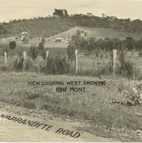
Document - Property Titles, Transfer of Land Act - "Pinemont", Ringwood, Victoria
Folder containing copies of LANDATA documents relating to "Pinemont", Panorama Avenue, Ringwood, Victoria, compiled for potential real estate sales background information purposes. Title Vol 965 Fol 923 Allotment 27B Parish of Warrandyte - James Forbes, dated 30th August, 1876. Title Vol 5236 Fol 1947157 Lots 294 and 370 on Plan of Subdivision no.11392 - Anthony Loughnan, dated 4th March, 1927. Title Vol 6415 Fol 1282937 Lot 294 on Plan of Subdivision no.11392 - Jessie McCracken Rothwell Woodard, dated 9th September, 1940. -
 Ringwood and District Historical Society
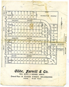
Document, Glen Turnbull, Land Sale Brochure - Heathmont Hills Estate - subdivision of Stan Wieland's Land (undated), 25/2/2008
... Land Sale Brochure - Heathmont Hills Estate - subdivision... Avenue. Land Sale Brochure - Heathmont Hills Estate - subdivision ...Small brochure by Glide Farrell & Co, real estate and Business Agents, Melbourne advertising "93 Superb Building Blocks 3Mins Station & Shops", and "Sky-Line Views of Heathmont Hills Estate" , comprising lots in Dresden Ave, Doulton Ave, Devon Ave, Viviana Crescent, Leoni Avenue. -
 City of Moorabbin Historical Society (Operating the Box Cottage Museum)
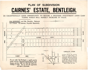
Flyer - Plan of subdivision for Cairnes' Estate, Bentleigh, mid 1920's
Land sales in the Municipality of Moorabbin increased when the train line from the City to Frankston was electrified.Example of the progress of the Municipality of MoorabbinExample of the progress of the Municipality of MoorabbinAdvertising flyer for auction of real estate sales - plan of building blocks for saleCairnes' Estate, Bentleigh 38 home sites and 14 business sitescentre road, cairnes grove, ansett grove, brewers road, bentleigh, land sales, real estate -
 City of Moorabbin Historical Society (Operating the Box Cottage Museum)
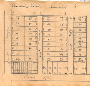
Plan - Grandview Estate
The train line from the city to Frankston was electrified in 1922 which intensified the sale in the municipality of Moorabbin, particularly land which was in the vicinity of the railway stations.The train line from the city to Frankston was electrified in 1922 which intensified the sale in the municipality of Moorabbin, particularly land which was in the vicinity of the railway stations. The Grandview Estate was auctioned on Saturday 10 November 1922.Example of the progress of the Municipality of MoorabbinHand drawn map of subdivision Grandview Estate, Bentleighcentre road, evelyn street (now wilson street), lily street, bentleigh, realestate, auction -
 City of Moorabbin Historical Society (Operating the Box Cottage Museum)
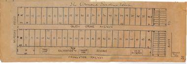
Plan - Ormond Garden Estate, Ormond, 1920
At the end of World War One, there was a renewed interest in residential land and a number of estates opened up in the Municipality of Moorabbin. Ormond Garden Estate was auctioned on Saturday 10 April, 1920.Example of the progress of the Municipality of MoorabbinHand drawn plan of subdivisionOrmond Garden Estatenorth road, glen orme avenue, murray road, ormond, auction, real estate -
 City of Moorabbin Historical Society (Operating the Box Cottage Museum)
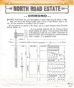
Flyer - North Road Estate, Ormond
At the end of World War One, there was a renewed interest in residential land and a number of estates opened up in the Municipality of Moorabbin.Example of the progress of the Municipality of MoorabbinAdvertising flyer for auction of real estate sales - plan of building blocks for saleNorth Road Estate, Ormond - plan of subdivision.36north road, wicklow st, leinster st, ormond, real estate -
 City of Moorabbin Historical Society (Operating the Box Cottage Museum)
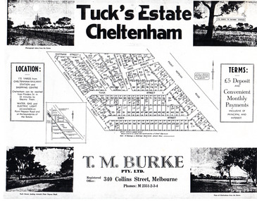
Flyer - Tuck's Estate, Cheltenham, 1940
After WWII there was a decline in the market gardens in the City of Moorabbin, as the value of the land was more profitable than the crops.Example of the progress of the Municipality of MoorabbinPhotocopy of advertising flyer for sale of real estate sales - plan of building blocks for saleTuck's Estate Cheltenham - plan of subdivisionedward street, point nepean road, eden street, tuck street, hoffman street, elman road, page street, cheltenham, real estates, auction, tuck -
 City of Moorabbin Historical Society (Operating the Box Cottage Museum)
Document - Tenth Anniversary - Presbyterian Church East Bentleigh, 1957 - 1967, 1967
... subdivision of land... subdivision of land religion Document with blue cover, 18 pages ...Presbyterian Church East Bentleigh, built in 1957 in Cecil Street East Bentleigh. The site and building is now (2022) being used by Chabad, Bentleigh, which serves to cater to the needs of the Jewish Community.Presbyterian Church Bentleigh was formed to cater for the growing population of Bentleigh when the market gardens were subdivided into residential blocks.Document with blue cover, 18 pages. Contains text and pictures.parish of moorabbin, city of moorabbin, county of bourke, shire of moorabbin, market gardeners, presbyterian church east bentleigh, cecil street, east bentleigh, subdivision of land, religion -
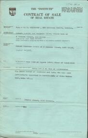
 Bendigo Historical Society Inc.
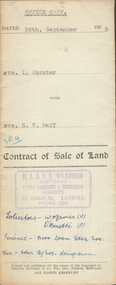
Document - H.A. & S.R. WILKINSON COLLECTION: CONTRACT OF SALE
Contract of sale of land dated 26th September, 1955 between Mrs. I. Forster (seller) and Mrs. E.V. Raff (buyer) for land being lot 2 on plan of subdivision No.3905 lodged at the office of titles being part of Crown allotment 8 section 8 portion B described in certificate of title volume 4045 folio 961 situate No. 142 Myrtle Street, Bendigo. Together with right of carriage way over land at rear of property with weatherboard dwelling and all sundry, also all floor coverings, blinds, curtains, electric light fittings and shades and 'Pope' washing machine. Price 3,200 pounds.organization, business, h.a. & s.r wilkinson real estate -
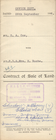 Bendigo Historical Society Inc.
Document - H.A. & S.R. WILKINSON COLLECTION: CONTRACT OF SALE
Contract of sale of land dated 28th September, 1956 between G.A. Cox (seller) and Mr. R.L. & Mrs. E. Roche (buyer) for land being lot 1 on plan of subdivision No. 18242 part of Crown allotment 337 section E described in certificate of title volume 7132 folio 389 and situate no. 150 White Hills Road, Bendigo, together with 5-roomed brick dwelling and all sundry. Price 4,750 pounds.organization, business, h.a. & s.r wilkinson real estate -
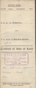 Bendigo Historical Society Inc.
Document - H.A. & S.R. WILKINSON COLLECTION: CONTRACT OF SALE
Contract of sale of land dated 22nd November, 1956 between Mr. W.N. Nicholls (seller) and Mr. G.A. & Mrs. M.L. Quirk (buyers) for piece of land being lot 17 of plan of subdivision No. 33303 lodged in the office of titles being part of Crown allotment 16 section 7A, Kangaroo Flat and situate corner Camp and carpenter Streets, Kangaroo Flat, together with brick veneer dwelling and all sundry, also all electric light fittings and shades. Price 4,500 pounds.organization, business, h.a. & s.r wilkinson real estate -
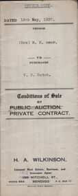 Bendigo Historical Society Inc.
Document - H.A. & S.R. WILKINSON COLLECTION: CONTRACT OF SALE
Conditions of sale by private contract dated 13th May, 1937 between Mrs. M.H. Amor (seller) and V.F. Sutch (buyer) for land situate Hayes Street, Bendigo being lot 2 on plan of subdivision, having a frontage of approx. 57 feet to Hayes Street, by a varying depth, being part of Crown allotment 510 section A. Price 60 pounds.organization, business, h.a. & s.r wilkinson real estate -
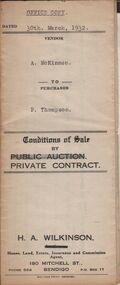 Bendigo Historical Society Inc.
Document - H.A. & S.R. WILKINSON COLLECTION: CONTRACT OF SALE
Conditions of sale by private contract dated 30th March, 1932 between A. McKinnon (seller) and P. Thompson (buyer) for land situate in Murphy Street, Bendigo being the balance of the subdivision unsold of Crown allotment 151,270A, 271A, 271C, 271R, 195, 196, 270C, 271B and 271D described in certificate of title volume 2666 folio 533101, and being the land at present occupied by the vendor, not including the allotments or read showed on plan of subdivision. Together with weatherboard dwelling and all sundry including galvanized iron tank and stand, water trough and loose timber in paddock but does not include any window or verandah blinds. Price 800 pounds.organization, business, h.a. & s.r wilkinson real estate -
 Bendigo Historical Society Inc.
Document - H.A. & S.R. WILKINSON COLLECTION: CONTRACT OF SALE
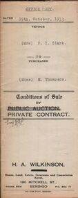
Conditions of sale by private contract dated 19th October, 1933 between Mrs. P.I. Clark (seller) and Miss M. Thompson (buyer) for land situate McIvor Road, Bendigo being lots 2,5 and 6 on plan of subdivision No. 13539 and being Crown allotment 196 and parts of Crown allotments 151,195 and 270A section H described in certificate of title volume 5756 folio 1151098, together with all fences and erections thereon. Price 150 pounds.organization, business, h.a. & s.r wilkinson real estate -
 Bendigo Historical Society Inc.
Document - H.A. & S.R. WILKINSON COLLECTION: CONTRACT OF SALE
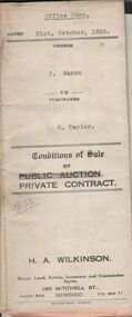
Conditions of sale by private contract dated 21st. October, 1935 between J. Mahon (seller) and H. Taylor (buyer) for land situate Hodgkinson Street, Bendigo having a frontage of approx. 52 feet by a depth of approx. 108 feet, being parts of lots 6 and 7 on plan of subdivision registered No.13862 part of Crown allotments 6 and 7 section 38C land described in Crown grant volume 1502 folio 300225 and Crown grant volume 2642 folio 528242. Price 50 pounds. Attached receipt and plans to build house on that land (W. H. Ellis builder) for 500 pounds also attached detailed list of materials and labour.organization, business, h.a. & s.r wilkinson real estate -
 Bendigo Historical Society Inc.
Document - H.A. & S.R. WILKINSON COLLECTION: CONDITION OF SALE
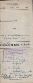
Contract of sale of land dated 23rd June, 1952 between Mr. J.L.C. Hunt (seller) and Miss D.A. Phillips for land being Lot 18 on plan of subdivision No. 14194, being part of Crown allotments 454A and 476 section H described in certificate of title volume 6110, folio 975 situate in Murray Street, Bendigo, together with 50roomed weatherboard dwelling and all sundry. Price 2,525 pounds.organization, business, h.a. & s.r wilkinson real estate -
 Bendigo Historical Society Inc.
Document - H.A. & S.R. WILKINSON COLLECTION: CONDITION OF SALE
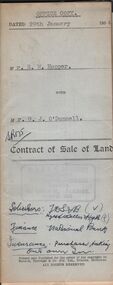
Contract of sale of land dated 29th January 1954 between Mr. E.M. Hopper (seller) and Mr. G.J. O'Donnell (buyer) for land being Lot 2 on plan of subdivision No. 23332 registered in the office of titles, Melbourne and situate in Lindsay Street Kangaroo Flat part of Crown allotment 11 section 23, township of Kangaroo Falt described in Certificate of title volume 7446 folio 423, together with weatherboard dwelling, wood shed-lavatory also fencing on the said land. Price 2,700 pounds.organization, business, h.a. & s.r wilkinson real estate -
 Bendigo Historical Society Inc.
Document - H.A. & S.R. WILKINSON COLLECTION: CONDITION OF SALE
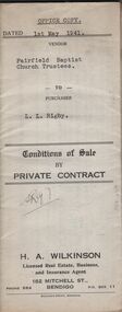
Conditions of sale by private contract dated 1st May, 1942 Fairfield Baptist Church Trustees (William Alfred Newnham, Harry Marsh, Joseph Butters Hughes, James Arthur Dobson as trustees and sellers) and L.L. Rigby (buyer) for land having a frontage of 41 feet to the west of Arthur Street by a depth of 130 feet along the north side of Duncan Street being part of lot 81 on plan of subdivision No. 568 lodged in the office of titles and being part of Crown Portion 114 Parish of Jika-Jika County of Bourke described in certificate of title volume 3540 folio 707982 together with all buildings thereon and known as 98 Arthur Street Fairfield. Price 660 pounds.organization, business, h.a. & s.r wilkinson real estate -
 Bendigo Historical Society Inc.
Document - H.A & S.R. WILKINSON COLLECTION: CONDITION OF SALE
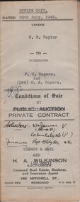
Conditions of sale by private contract issued by Bishop & Earl and H.A. Wilkinson and dated 25th July, 1949 between C.M. Taylor(seller) and F.W. Rogers + D.J. Rogers (buyers) land situate No. 47 Reginald Street Bendigo at present occupied by the purchaser as tenant, being part of Crown allotment 23 section 104C described in Crown grant volume 2052 folio 410334 as per plan of subdivision approved by the Bendigo Council, together with 4-roomed weatherboard dwelling and all sundry. Price 1,100 poundsorganization, business, h.a. & s.r wilkinson real estate -
 Bendigo Historical Society Inc.
Document - H.A. & S.R. WILKINSON COLLECTION: CONDITION OF SALE
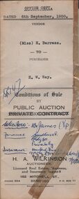
Conditions of sale by public auction issued by H.A. Wilkinson and dated 6th September 1950 between miss H. Barrass (seller) and H. W. Ray (buyer) for land situate No. 139 Queen Street Bendigo at present occupied by Mr. L.J. Lobb a tenant, being lot 1 on plan of subdivision made by Mr. A.E. Pritchard dated 13th August 1950 and being part of Crown allotment 10 section 90C, together with 5-roomed weatherboard dwelling and all sundry. Subject to existing weekly tenancy. Price 870 pounds.organization, business, h.a. & s.r wilkinson real estate -
 Bendigo Historical Society Inc.
Document - H.A. & S.R. WILKINSON COLLECTION: CONDITION OF SALE
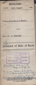
Contract of sale of land issued by H.A. Wilkinson and dated 15th August, 1952 between Mrs. L.M. & Mr. K. J. Monti (sellers) and Mr. W.J. Rielley for land being Lot 3 on plan of subdivision lodged in the office of titles in red ink No. 5062838 and being part of Crown allotment 20A section 16, City of Bendigo, Parish of Sandhurst, County of Bendigo and situate in Napoleon Crescent, White Hills, together with 6-roomed weatherboard dwelling and all sundry. Price 2,850 pounds.organization, business, h.a. & s.r wilkinson real estate -
 Bendigo Historical Society Inc.
Document - H.A. & S.R. WILKINSON COLLECTION: CONDITION OF SALE
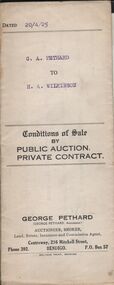
Conditions of sale by private contract dated 20th April 1925 between G. A. Pethard as seller and H. A. Wilkinson as buyer. Contract issued by George Pethard Auctioneer for sale of land situate in Elizabeth Street Nyah West being lot 100 on plan of subdivision No. 6415 lodged in the office of titles and being part of Crown Allotment 11 Parish of TynTynder West County of Tatchera described in certificate of title volume 4642 Folio 928297, together with 4-roomed weatherboard dwelling. Price 518 pounds.organization, business, h.a. & s.r wilkinson real estate -
 Bendigo Historical Society Inc.
Document - H.A. & S.R. WILKINSON COLLECTION: CONTRACT OF SALE
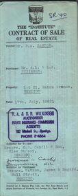
Contract of sale of real estate between Mr. R.A. Santon (vendor) and Mr. A.L. & A.K. Stringer (purchaser) dated 17th, July, 1962. Solicitor for vendor: Messrs. E.S. Cahill & Son, View Street, Bendigo. Solicitor for purchaser: Messrs Watson, James & Rogers, Bull Street, Bendigo. Property: Lot 21, Mahon Avenue, Bendigo, being lot 21 on plan of subdivision no. 31961 lodged in the office of titles parish of Sandhurst and being the whole of the land comprised in certificate of title volume 8310 folio 930 having a frontage of 53 feet to Mahon Avenue by a depth of 120 feet. Price 550 pounds.organization, business, h.a. & s.r wilkinson real estate -
 Bendigo Historical Society Inc.
Document - H.A. & S.R. WILKINSON COLLECTION: CONTRACT OF SALE
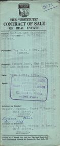
Contract of sale of real estate dated 12th April, 1961 between Bendigo and Eaglehawk Star Permanent Building Society (vendor) and Mr.E.A. & Mrs. L.M. Spence (purchaser). Solicitor for vendor: Messrs. Watson, James & Rogers, Bull Street, Bendigo. Solicitor for purchaser: Messrs. Hyett, Willis & Hyett, Bull Street, Bendigo. Property: vacant land corner Holdsworth Road and Britton Street, Bendigo being lot 3 on plan of subdivision No. 52449, having a frontage of 56 feet 7 inches with a width at the rear of 58 feet 5 inches with a depth of 97 feet 5.5 inches being part of crown allotment 31 section F at Bendigo described in Crown volume 8242 folio 057. Price 410 pounds.organization, business, h.a. & s.r wilkinson real estate -
 Bendigo Historical Society Inc.
Document - H.A. & S.R. WILKINSON COLLECTION: CONTRACT OF SALE
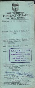
Contract of sale of real estate dated 22nd December, 1960 between Mr. W. B. Nicholls (vendor) and Mr. C. W. & Mrs. F. L. Silk (purchaser). Solicitor for vendor: Messrs Hyett, Willis & Hyett, Bull Street, Bendigo. Solicitor for purchaser: Messrs. Tatchell, Dunlop, Smalloy & Balmer, Williamson Street, Bendigo. Property: vacant land corner Derna Court and Poplar Street, Golden Square, being lots 20,21,22,23,24, 25, 26 and 27 fronting Derna Courton plan of subdivision no. B80611 and lot 1 on plan of subdivision no. 51583 lodged in the office of titles and being part of Crown allotment 11 section 24A at Bendigo described in Crown grant volume 8217 folio 121. Price 4,900 pounds .organization, business, h.a. & s.r wilkinson real estate -
 Bendigo Historical Society Inc.
Document - H. A. & S. R. WILKINSON COLLECTION: CONTRACT OF SALE
Contract of sale of real estate dated 22nd January, 1966 between Mrs. M. R. Potter (vendor) and Mr. M. L. Smart (purchaser). Solicitor for vendor: Messrs. E. S. Cahill & Son, View Street, Bendigo. Solicitor for purchaser: Messrs. Watson, James & Rogers, Bull Street, Bendigo. Property 3 Atkins Street, Bendigo being lot 1 on plan of subdivision No. 35034 lodged in the office of titles being part of Crown allotment 516B section K land described in certificate of title volume 8103 folio 921 together with all floor coverings, blinds, curtains and electric light fittings and shades. Price 2,500 pounds.organization, business, h.a. & s.r wilkinson real estate -
 Bendigo Historical Society Inc.
Document - H. A. & S. R. WILKINSON COLLECTION: CONTRACT OF SALE
Contract of sale of real estate dated 3rd December, 1964 between Mr. J. M. Gill (vendor) and Mr. C. Sartori (purchaser). Solicitor for vendor: Messrs. E. S. Cahill & Son, View Street, Bendigo. Solicitor for purchaser: Mr. H. E. Every, Dispensary Walk, Bendigo. Vacant land, Lot 16 hunter avenue, California Gully being lot 16 on plan of subdivision No. 55883 being part of Crown allotment 226 section N land described in certificate of title volume 8158 folio 238. Price 120 pounds.organization, business, h.a. & s.r wilkinson real estate -
 Bendigo Historical Society Inc.
Document - H. A. & S. R. WILKINSON COLLECTION: CONTRACT OF SALE
... being lot 29 on plan of subdivision No. 60209 land described... Morsehead Court, White Hills being lot 29 on plan of subdivision ...Contract of sale dated 16th July 1964 between Mr. W. B. & W. B. Nicholls (vendor) and Mr. A. E. & Mrs B. Stephens (purchaser). Solicitor for vendor: Messrs. Macaboy, Taylor & Taylor, Hargreaves Street, Bendigo. Solicitor for purchaser: Mr. H. E. & Mrs. B. M. Stephens. Lot 29 Morsehead Court, White Hills being lot 29 on plan of subdivision No. 60209 land described in certificate of title volumr 8434 folio 603. Price 3950 pounds.organization, business, h.a. & s.r wilkinson real estate -
 Bendigo Historical Society Inc.
Document - H. A. & S. R. WILKINSON COLLECTION: CONTRACT OF SALE
Contract of sale of real estate dated 18th December, 1963 between Mr G. A. & Mrs. N M. Wells (vendor) and Mr. H. G. & Mrs. M. E. Stephenson (purchaser). Property: 82 Hargreaves Street, corner Arnold Street, Bendigo, being lot 2 on plan of subdivision No. 28382 lodged in the office of titles, being part of Crown allotment 15 section 92C land described in certificate of title volume 4335 folio 826 together with floor coverings, blinds, curtains, electric light fittings and shades, gas stove in kitchen and gas fire heater in lounge room. Price: 3,250 pounds.organization, business, h.a. & s.r wilkinson real estate -
 Bendigo Historical Society Inc.
Document - H. A. & S. R. WILKINSON COLLECTION: CONTRACT OF SALE
... Bendigo being lot 3 on plan of subdivision No. 52992 land... of subdivision No. 52992 land described in certificate of title volume ...Contract of sale of real estate dated 8th November, 1963 between Mr. R. P. & Mrs. M. O. Miller (vendor) and Mr. E. C. Spence (purchaser). Solicitor for vendor: Watson, James & Rogers, Bull Street, Bendigo. Solicitor for purchaser: Watson, James & Rogers, Bull Street, Bendigo. Property: Sterry Street, West Bendigo being lot 3 on plan of subdivision No. 52992 land described in certificate of title volume 8399 folio 464. Price: 400 pounds.organization, business, h.a. & s.r wilkinson real estate