Showing 44496 items
matching land-conservation-east-gippsland
-
 Vision Australia
Plan - Text, Allom Lovell and Associates, RVIB Conservation Management plan, 2002
Commissioned by the RVIB, this Conservation Management plan provides an assessment of the cultural significance of the buildings and develop conservation policies around future management of the site.1 CD with 1 Word fileroyal victorian institute for the blind, buildings -
Lakes Entrance Regional Historical Society (operating as Lakes Entrance History Centre & Museum)
Photograph, Lakes Post Newspaper, 1/10/1994 12:00:00 AM
Black and white photograph of winners of the Recfish competition Russell Cormack, Gary Atherton Des Radford Erin Playdell Con Koziaris Daniel Micah Kayle White and Rhys Allitt East Gippsland Victoriafish, clubs -
 Orbost & District Historical Society
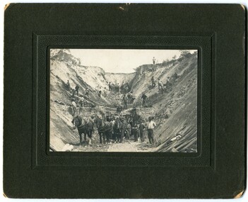
black and white photograph, early 20th century
There is no information with this photograph. It could be associated with the construction of the East Gippsland Railway.This is a pictorial record of construction work in the early 20th century. It shows the use of hand tools and horse and cart transport.A black / white photograph on a black buff card. It shows men working with picks and shovels to construct a pass. There is a horse and cart in the foreground.road-construction railway-construction civil-engineering -
 Greensborough Historical Society
Document - Certificate of Title, Partington land, 30/09/1878
Certificates of title and associated documents relating to land owned by Charles Partington: Vol. 3200 Vol. 639882; 30/09/1878. Includes transfer of title to executors William James Partington and Maria Partington on the death of Charles Partington 16/05/1907.Shows part of the chain of ownership of this parcel of land in Greensborough. The Partingtons were Greensborough pioneers5 pages. Copies of land titles and associated documentsland titles - greensborough, partington family -
 Orbost & District Historical Society
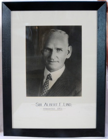
framed photo, APFA- Davisigns (PG & ME Davis)
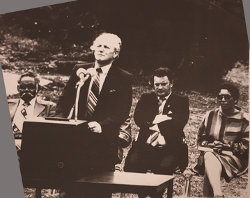
This photo was inherited with the building when the museum was established. Lind was born in 1878 in East Charlton, Victoria, the son of Oliver Nicholas Lind, a farmer from Denmark, and his Welsh wife Mary Ann Clay. In 1882, drought forced the family to move to East Gippsland where Lind was educated at Lucknow, and then to Bairnsdale in 1884 where he attended Bairnsdale state school. In October 1920, he was elected to the Victorian Legislative Assembly for the seat of Gippsland East for the Victorian Farmers' Union. Lind was made Minister of Forests, President of the Board of Land and Works and Commissioner of Crown Lands and Survey in Albert Dunstan's cabinet. He was knighted in 1951. In 1926 two national parks east of Orbost were named the Albert and the Lind national parks after him.A framed photo of Sir Albert Eli Lind. It is a black and white head and shoulders photo in a black wooden frame.Sir Albert E. Lind Knighted !951photograph politician lind-albert government -
Federation University Historical Collection
Document - Conservation Management Plan, Wendy Jacobs et al, Ballarat Municipal Observatory - Conservation Management Plan
A Conservation Management Plan of the Ballarat Municipal Observatory, produced by Dr David Rowe of Authentic Heritage Services Pty Ltd and Wendy Jacobs, Architect & Heritage Consultant for the City of Ballarat and the Ballaarat Astronomical Society in April 2007.astronomy, ballarat observatory, ballarat municipal observatory, conservation management plan, cmp -
 Federation University Historical Collection
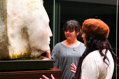
Photograph - Digital image, Gippsland Centre for Art and Design Students, 19/11/2013
Visual Arts students in a Courtyard at the Gippsland Campusarts academy, gippsland centre for art and design, churchill, visual arts, sculpture -
 Federation University Historical Collection
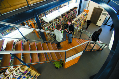
Photograph - Digital Image, Federation University Gippsland Campus Library, 06/08/2013
Colour photograph of students on a staircase at Gippsland Campus .gippsland campus, library, buildings, architectural features, gippsland campus collection, student residences -
 Federation University Historical Collection
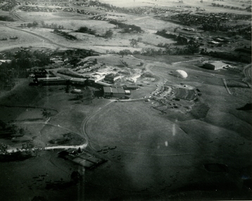
Photograph, Aerial View of the Gippsland Institute of Advanced Education, 1990-91
Aerial View of the Gippsland Institute of Advanced Educationgippsland campus collection, churchill, gippsland institute of advanced education, aerial -
 Federation University Historical Collection
Photograph, Aerial View of the Gippsland Institute of Advanced Education, c1980s
Aerial View of the Gippsland Institute of Advanced Educationgippsland campus collection, churchill, gippsland institute of advanced education, aerial -
 Federation University Historical Collection
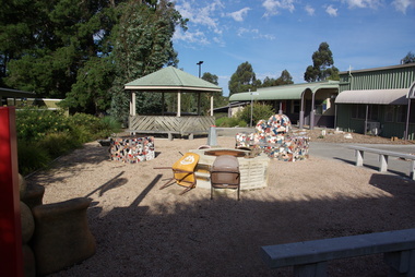
Photograph, Clare Gervasoni, Gippsland Visual Arts Courtyard, 06/10/2026
Colour photographs of the Gippsland Visual Arts Courtyardgippsland visual arts courtyard, churchill, giae, mosaic -
Lakes Entrance Regional Historical Society (operating as Lakes Entrance History Centre & Museum)
Book, Meridith Fletcher, Gippsland Heritage Journal, 1996
Life in various areas around Gippsland Victoriaagriculture, land settlement, migrants -
Lakes Entrance Regional Historical Society (operating as Lakes Entrance History Centre & Museum)
Book, Gippsland Heritage Journal - issue 3, 1988
Issue of a series containing articles on early Gippslandoccupation, health services, agriculture -
 Orbost & District Historical Society
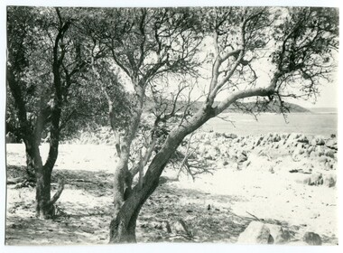
black and white photograph, first half 20th century
this photograph is of Cape Conran in Far East Gippsland. It appears to be a copy of a commercial postcard available to tourists or East Gippsland residents to send to friends or relatives.Cameras in the early 20th century were not a common family possession and a postcard was a common souvenir and way of sending a short message.Postcards form a vital part of social and historical records for researchers. A black / photograph of trees and a beach with rocks and the ocean in the background. It appears to be a copy of a postcard and has been hand trimmed.cape-conran -
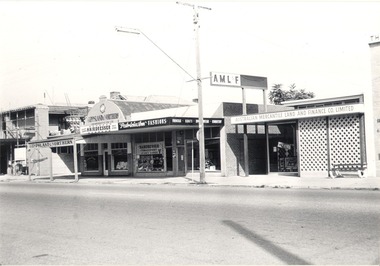 Wodonga & District Historical Society Inc
Photograph - Mann Collection Album - Terminus Hotel; Gippsland & Northern, C1960s - 1970s
This photo is part of a collection of Wodonga Town Photos donated by Elaine Mann. Elaine was married to David Mann, a successful Wodonga businessman and community leader who passed away in Wodonga in June 2012. David was a member of the Mann family who began their business in Wodonga in 1920. Elaine was a teacher in Wodonga for many years and an active member of the community. The Terminus Hotel In 1873, James Thompson Hatch built the two-storeyed Terminus Hotel at 79 Sydney Road (later known as High Street), then sold it to George Day and Kenneth McLennan for £1,230. It was first licensed to J. G. Morton in January 1874. In 1879, Annie Allen, from Ireland, took over as licensee of the hotel containing 14 rooms, after she and her husband, George James Allen, purchased it. He became licensee in 1883. Under the Allens, the Terminus became, ‘a principal rendezvous for visitors to the town.’ September 1888 saw additions to the building that included a billiard room, a dining room, and 18 other rooms. Following the death of her husband in 1889, Annie Allen continued to run the Terminus Hotel. She later married John Haldon and was licensee of the hotel until 1893 when the licence was transferred to William Carkeek. In the early 1900s the Hotel was thoroughly renovated. The Terminus Hotel was for sale by auction on 5th March 1909. It comprised about 50 rooms, a two-storey building built of brick and iron with hot and cold water service and acetylene gas throughout. The principal hotel in Wodonga, was let from 1st January 1909 on a seven years’ lease at a rental of £9 per week. 1935 saw extensive improvements by proprietor W. P. Kinney, while in 1941 further extensive improvements were carried out to make a good hotel better. A pall of shock and disbelief descended over Wodonga’s historic Terminus Hotel on 1st June 1998 when it was destroyed by fire then demolished in 1999. The site was sold for almost $1 million and redeveloped for a medical clinic.This photo collection is of significance as it documents how the businesses and buildings in Wodonga have evolved and contributed to community throughout the late 20th century.Terminus Hotel; Gippsland & Northern Co-operative Pty. Ltd.; Graham Bradbury Men's Hairdresser; Patricia Anne Fashions; Australian Mercantile Land and Finance Company (A.M.L. & F). on the west side of High Street. The Terminus Hotel was built C. 1873. and was destroyed by fire in 1998, The Gippsland and Northern Co-operative Co. Ltd was formed in 1905, but the date of its establishment in Wodonga is not confirmed, but they were holding fortnightly sales at the Wodonga sale yards by early 1919.wodonga businesses, high st wodonga, terminus hotel, gippsland & northern -
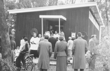 Ringwood and District Historical Society
Photograph, Church of England, Patterson Street, East Ringwood, Vic. - circa 1960
Church of England Church at East Ringwood with people leavingWritten on back of photograph, "E. Rwd." Church of England Church at East Ringwood -
 Victorian Interpretive Projects Inc.
Photograph - colour, Clare Kathleen Gervasoni, Former Ballarat East Library, 2015, 05/04/2015
Colour photographs of a brick building which is the former Ballarat East Library.ballarat east library, ballarat east high school, ballarat school of mines -
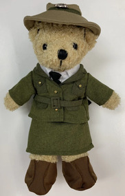 Melbourne Legacy
Leisure object - Toy Bear, Legacy Bear $20 - Female Land Army Bear, 2022
In the 2000s Legacy released a range of Legacy Bears to expand the merchandise available for sale during Legacy Week and at other fundraising opportunities during the year. This special edition WW2 land army bear was released in 2019. The Women's Land Army (WLA) was a British civilian group created during World War II to replace the men called up for the military. Over 80,000 women served working on farms, in sawmills, and in forestry. They became know as Land Girls and Lumber Jills. Please note the archive does not have a copy of this bear but is recorded here to complete the series.An example of the type of products sold along with Legacy Badges for fundraising in the 2010-2020s.Legacy bear dressed in a female WW2 Land Army uniform with a printed cardboard tag.Printed tag gives the price as $20.legacy appeal, fundraising, legacy bear -
 Greensborough Historical Society
Document - Certificate of Title, Mayger land, 1863o
Land originally granted to John Alison 09/09/1840. 1. Certificate of Title: Edwin Willis Mayger 14/08/1863: Vol. 5 Fol. 860. 2. Transfer document: 2 mortgages for Edwin Willis Mayger; Transfer from Mayger to Charles Partington. Shows part of the chain of ownership of this parcel of land in Greensborough.2 pages. Copies of land titles and associated documentsland titles - greensborough, mayger family, partington family, maygar family -
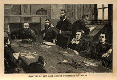 Ballarat and District Irish Association
Image, Land League Committee Meeting, Dublin, 1864
The Irish National Land League (Irish: Conradh na Talún) was an Irish political organisation of the late 19th century which sought to help poor tenant farmers. Its primary aim was to abolish landlordism in Ireland and enable tenant farmers to own the land they worked on. The period of the Land League's agitation is known as the Land War. Within decades of the league's foundation, through the efforts of William O'Brien and George Wyndham (a descendant of Lord Edward FitzGerald), the 1902 Land Conference produced the Land (Purchase) Act 1903 which allowed Irish tenant farmers buy out their freeholds with UK government loans over 68 years through the Land Commission (an arrangement that has never been possible in Britain itself). For agricultural labourers, D.D. Sheehan and the Irish Land and Labour Association secured their demands from the Liberal government elected in 1905 to pass the Labourers (Ireland) Act 1906, and the Labourers (Ireland) Act 1911, which paid County Councils to build over 40,000 new rural cottages, each on an acre of land. By 1914, 75% of occupiers were buying out their landlords, mostly under the two Acts. In all, under the pre-UK Land Acts over 316,000 tenants purchased their holdings amounting to 15 million acres (61,000 km2) out of a total of 20 million acres (81,000 km2) in the country. Sometimes the holdings were described as "uneconomic", but the overall sense of social justice was undeniable. (http://en.wikipedia.org/wiki/Irish_National_Land_League, accessed 21 January 2014) The Irish National Land League was founded at the Imperial Hotel in Castlebar, the County town of Mayo, on 21 October 1879. At that meeting Charles Stewart Parnell was elected president of the league. Andrew Kettle, Michael Davitt, and Thomas Brennan were appointed as honorary secretaries. This united practically all the different strands of land agitation and tenant rights movements under a single organisation. The two aims of the Land League, as stated in the resolutions adopted in the meeting, were: ...first, to bring out a reduction of rack-rents; second, to facilitate the obtaining of the ownership of the soil by the occupiers. That the object of the League can be best attained by promoting organisation among the tenant-farmers; by defending those who may be threatened with eviction for refusing to pay unjust rents; by facilitating the working of the Bright clauses of the Irish Land Act during the winter; and by obtaining such reforms in the laws relating to land as will enable every tenant to become owner of his holding by paying a fair rent for a limited number of years. Charles Stewart Parnell, John Dillon, Michael Davitt, and others including Cal Lynn then went to America to raise funds for the League with spectacular results. Branches were also set up in Scotland, where the Crofters Party imitated the League and secured a reforming Act in 1886. The government had introduced the first ineffective Land Act in 1870, then the equally inadequate Acts of 1880 and 1881 followed. These established a Land Commission that started to reduce some rents. Parnell together with all of his party lieutenants, including Father Eugene Sheehy known as "the Land League priest", went into a bitter verbal offensive and were imprisoned in October 1881 under the Irish Coercion Act in Kilmainham Jail for "sabotaging the Land Act", from where the No-Rent Manifesto was issued, calling for a national tenant farmer rent strike which was partially followed. Although the League discouraged violence, agrarian crimes increased widely. Typically a rent strike would be followed by evictions by the police, or those tenants paying rent would be subject to a local boycott by League members. Where cases went to court, witnesses would change their stories, resulting in an unworkable legal system. This in turn led on to stronger criminal laws being passed that were described by the League as "Coercion Acts". The bitterness that developed helped Parnell later in his Home Rule campaign. Davitt's views were much more extreme, seeking to nationalise all land, as seen in his famous slogan: "The land of Ireland for the people of Ireland". Parnell aimed to harness the emotive element, but he and his party preferred for tenant farmers to become freeholders on the land they rented, instead of land being vested in "the people".(http://en.wikipedia.org/wiki/Irish_National_Land_League, accessed 21 January 2014)Image of a number of men sitting around a table. They are members of the Land League Committee during a meeting in Dublin.ballarat irish, land league, land league committee, dublin -
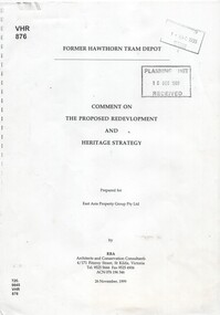 Melbourne Tram Museum
Document - Report, RBA Architects and Conservation Consultants, "For Hawthorn Tram Depot - Comment on the proposed redevelopment and Heritage Strategy", Nov. 1999
Report - 33 A4 pages - photocopied - titled "For Hawthorn Tram Depot - Comment on the proposed redevelopment and Heritage Strategy" Prepared by RBA Architects and Conservation Consultants of St Kilda for the East Asia Property Group Pty Ltd, 26/11/1999. Has a table of contents, gives a description of the proposed works, the site, the buildings, the proposed use, the two sheets, Tower wagon shed, the proposals and comments on Potential Impact of Development on the Cultural Heritage Significance. See Reg Item 550 for "Hawthorn and Malvern Tram Depots - Conservation Report"trams, tramways, hawthorn depot, conservation planning, tram museum -
 Kew Historical Society Inc
Photograph, East Kew Women's Club, Carlo Giardina, 1950s
The East Kew Women’s Club was formed on 20 July 1945 as an experiment amongst local women, who felt that there was a need for some organised group to give full scope to their various interests and hobbies. In the beginning, they met at the house of their founder, Mrs Eric Thake, 48 Harp Road, East Kew, but the growth and interest was so rapid that it was soon necessary to find a larger meeting place, so the group moved to the Harrier’s Pavilion in Victoria Park, Kew. At the fifth meeting of the group, a committee was formed, and a constitution adopted on 4 December 1945.The Club was aimed to be non-political, non-sectarian and open to women from any locality. The Club’s motto was “To Help others, Improve Ourselves, and Foster the Community Spirit”. The first twenty years of the Club was recorded in a small, nine-page publication “East Kew Women’s Club : Twenty Years 20-7-1945 - 30-7-1965”. Following the closure of the Club in 1973, after twenty-eight years, its records were deposited with the Kew Historical Society and are thus available for research into the history of women’s groups in the post war period in Australia. The Society holds the Club’s Minute Books of Meetings (1953-73), Attendance Registers (1959-73), Visitors Book, and sundry items of print ephemera published by the Club.Black and white photograph of Carlo Giardina, an Italian boy who was sponsored by the East Kew Women's Club. The photograph is stuck into one of their registers.east kew women's club, carlo giardina -
 Kew Historical Society Inc
Photograph, East Kew Women's Club, Marlene Higgins, 1950s
The East Kew Women’s Club was formed on 20 July 1945 as an experiment amongst local women, who felt that there was a need for some organised group to give full scope to their various interests and hobbies. In the beginning, they met at the house of their founder, Mrs Eric Thake, 48 Harp Road, East Kew, but the growth and interest was so rapid that it was soon necessary to find a larger meeting place, so the group moved to the Harrier’s Pavilion in Victoria Park, Kew. At the fifth meeting of the group, a committee was formed, and a constitution adopted on 4 December 1945.The Club was aimed to be non-political, non-sectarian and open to women from any locality. The Club’s motto was “To Help others, Improve Ourselves, and Foster the Community Spirit”. The first twenty years of the Club was recorded in a small, nine-page publication “East Kew Women’s Club : Twenty Years 20-7-1945 - 30-7-1965”. Following the closure of the Club in 1973, after twenty-eight years, its records were deposited with the Kew Historical Society and are thus available for research into the history of women’s groups in the post war period in Australia. The Society holds the Club’s Minute Books of Meetings (1953-73), Attendance Registers (1959-73), Visitors Book, and sundry items of print ephemera published by the Club.Black and white photograph of Marlene Higgins, an Aboriginal girl who was sponsored by the East Kew Women's Club. The photograph is stuck into one of their registers.east kew women's club, community organisations -- kew east (vic.), aboriginal and torres straight islander -
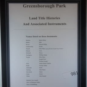 Greensborough Historical Society
Folder of Documents, Greensborough Park: Land Title Histories and Associated Instruments, 1872-1976
Land title documents trace the ownership of what is now known as Greensborough Park from 1872 to 1976.This property was owned at various times by well known Greensborough identities. The documents show the change from private ownership to public ownership of the site.Folder of copies of land title documents. 20 pages. Includes CD of electronic copies.greensborough park, banyule city council, shire of heidelberg, shire of diamond valley -
 Whitehorse Historical Society Inc.
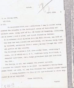
Legal record - Correspondence, Land valuation, 28/04/1988 12:00:00 AM
Valuation of land, North East corner of Canterbury and Middleborough Roads, part of C.A. Parish of Nunawading,Valuation of land, North East corner of Canterbury and Middleborough Roads, part of C.A. Parish of Nunawading, 44 acres, weatherboard house on property and outbuildings. Value 5,400 pounds.Valuation of land, North East corner of Canterbury and Middleborough Roads, part of C.A. Parish of Nunawading, land values, ellingworth, john roger, middleborough road, blackburn, canterbury road -
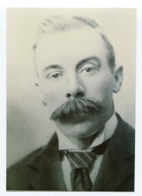 Orbost & District Historical Society
black and white photograph, C1926
This is a photograph of Councillor J. Walker who represented East Riding on the Orbost Shire council from 1915 - 1926.This item is associated with the Orbost Shire Council. The shire covered an area of 9,347 square kilometres and existed from 1892 until 1994 when it became part of the East Gippsland Shire Council.A black / white head and shoulders portrait photograph of a moustached man in a suit.on back - "Cr J. Walker, East Riding 1915-1926"walker-j. orbost-shire-council -
Kew Historical Society Inc
Archive (Sub-series) - Subject File, Conservation Study (Kew) 1990-1, 1990
Various partiesReference, Research, InformationSecondary Values (KHS Imposed Order)Subject file containing information about a follow-up conservation study in the City of Kew, following that by Pru Sanderson, undertaken by A Bryce Haworth. The Study reviewed Sanderson’s recommendations regarding the classification of A, B, and C graded buildings in Kew.conservation studies -- kew (vic.), a bryce haworthconservation studies -- kew (vic.), a bryce haworth -
Lakes Entrance Regional Historical Society (operating as Lakes Entrance History Centre & Museum)
Photograph, 2005c
Black and white photograph showing team of fourteen bullocks pulling a wagon load of produce with driver walking at side on wide and well maintained road, tall thick forest either side, East Gippsland Victoriaagriculture, machinery -
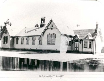 Federation University Historical Collection
Photograph - Photograph - black and white, Ballarat East State School (No 1071)
The weatherboard Ballarat East State School SS 1071 was formerly known as Specimen Hill. According to 'Visions and Realisations' The Eureka gold lead opened in August 1852, running from Little Bendigo, south beneath Yarrowee Creek into Pennyweight flat, where it was joined 100 yards or so from the intersection of main and Eureka Streets by the Canadian Lead. State School 1071 was formerly known as Ballarat Common School No. 71, and was founded by the Free Presbyterian Church on Specimen Hill in Eureka Street, Ballarat on 01 January 1854. On 20 May 1869 the trustees of the Presbyterian School, Specimen Hill, Ballarat, consented to the transfer of the site to the Board of Education. On 01 September 1870, Specimen Hill, Ballarat, was vested in the Board and then became known as SS 1071. On 01 March 1879 the Minister, The Hon. William Collard Smith, and William Dobbie, Inspector of School Buildings, visited Ballarat to report on the buildings with a view to extensions and renovations. The minister issued instructions for the old wooden part of the school to be demolished, and brick additions to be erected, so that the whole premises would accommodate 350 students. (''Visions and Realisations: A Century of State Education in Victoria, Vol. 2'', Education Department of Victoria, 1973, p 729-730.)Black and white photograph of a weatherboard school with shingle roof known as Ballarat East (SS1071). The building has a brick chimney and bell tower. This school has Castlemaine flagging in the passages.ballarat east state school, education, st paul's school, specimen hill state school -
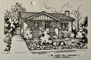 Kew Historical Society Inc
Drawing - Property Illustration, Margaret Picken, 94 Kilby Road, Kew East, 1983-2006
After training as a Cartographic Draftsman within the mining industry, I worked as a property illustrator for real estate firms in the eastern suburbs of Melbourne for 23 years from 1983. I initially photographed houses with a Polaroid camera and made a 'thumbnail' sketch while there. The photos were used to scale off a sketch in pencil and then that sketch was overlaid with drafting film and the 'pen and ink' completed. The pens I used were the Rotring ‘Rapidigraph’ drafting pens. The ink was also made by Rotring (German).The film was ‘Rapidraw’, polyester drafting film, double matte. It takes a very fine line and doesn’t bleed. As well as house sketches, there were often floor plans and site plans ordered. Aerial sketches were ordered when the property needed an overall view. (Margaret Picken, 2020)This drawing is one of a series created by Margaret Picken for real estate agents in Melbourne between 1983 and 2006. Each work is signed and dated by the artist.Gift of Margaret Picken, 2020Pen and ink drawing on drafting film of 94 Kilby Road, Kew East by Margaret Picken.94 KILBY RD., KEW EAST / MARG. PICKEN artist -- margaret picken 1950-, property illustrations — buildings — kew east (vic.), 94 kilby road - kew east (vic)