Showing 2249 items matching "lister house"
-
 Glenelg Shire Council Cultural Collection
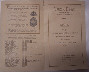
Souvenir - Souvenir - Presentation of the Mayoral Chain, 17th December 1955. Official dinner, 1955
Town of PortlandTwo-page cream card souvenir, folded in centre. Title, date and coat of arms on front page, historical details and toast list on centre pages, autograph page on back. Presentation of the Mayoral Chain, 17th December 1955. Official dinner.souvenir, mayoral chain, presentation -
 Glenelg Shire Council Cultural Collection
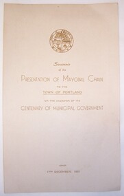
Souvenir - Souvenir Card, 1955
Town of PortlandTwp-sided cream card. On front is title, town coat of arms and date (17th December 1955). On back are further details of event and a listing of mayors from 1856-1955. Souvenir of the Mayoral Chain to the Town of Portland on the occasion of the Centenary of Municipal Governmentsouvenir, mayoral chain, portland -
 Glenelg Shire Council Cultural Collection
Flyer - Flyer - Upwelling Festival, 2012, c. 2012
Flyer advertising Upwelling Festival at Portland 3rd Nov, 2012. White card, blue and green motifs and print, Rotary club logo, front , bottom right. Reverse, list of activities, event sponsors.upwelling festival, marine ecology, whales, portland -
 Glenelg Shire Council Cultural Collection
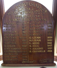
Award - Honour Board - Portland Old Boys Fraternity Honour Board, 1944
Displayed in History House.Wooden honour board in arched shape listing names in gold and black paint. -
Glenelg Shire Council Cultural Collection
Document - List - Ancient Order of Foresters, c. 1906
List of court nights for the year 1906, for Court Prosperity No. 3195 Ancient Order of Foresters. Printed form, dates added (or altered) in black penancient order of foresters, friendly society -
Glenelg Shire Council Cultural Collection
Pamphlet, Portland Rifle Club Rules, n.d
Two 4 page pamphlets, listing the rules of the Portland Rifle Club, white paper, black print -
Glenelg Shire Council Cultural Collection
Pamphlet - Brochure, Steam Packet Inn, n.d
The Steam Packet Inn is the second oldest building in Portland. It was licensed to an ex convict from Van Diemens Land (Tasmania) in 1841. Later became a police barracks. It is a heritage listed buildingYellow card, tri-fold brochure, containing history of Steam Packet Inn, Bentinck St. Portland. Photo of steam Packet Inn on front of brochure, floor plans on the back.steam packet inn, bentinck street, portland -
 Glenelg Shire Council Cultural Collection
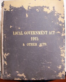
Book - Book - Local Government Act 1915 and Other Acts, Local Government Act 1915 and Other Acts, 1915
Brown cloth-covered board binding with title in gold lettering on cover. -
Glenelg Shire Council Cultural Collection
Document - Document - The Experiences and Impressions of a Chairman, 1969
Retrieved from the files of the former manager of the Portland Visitor Information Centre (6 copies of this are listed in the manifest from the Port of Portland when collection was offered in 1995Presented and bound document -The Experiences abd Impressions of a Chairman ' by K.S. Anderson 1950 -1961. Printed single sided, written by Keith Anderson in 1969Front: W Morrison - top right, biro, printed Original proof Port of portland History 1950-1961 Keith Anderson - biro, written -
Glenelg Shire Council Cultural Collection
Souvenir - Carry Bag - Casterton Kelpie Festival, n.d
Casterton Kelpie Festival.Yellow plastic carry bag from Visitor Information Centre at Casterton with Kelpie Country logo and list of events, in green. -
Glenelg Shire Council Cultural Collection
Administrative record - List - Ancient Order of Foresters, n.d
Small piece of lined paper, torn edges. A list of 4 items, written in pencil -
Glenelg Shire Council Cultural Collection
Administrative record - Book - Ancient Order of Foresters, c. 1874
Minutes book, hard cover, coloured 'wave' pattern, black spine. Rough minute book for Court Prosperity (Portland). No. 3915, for period 7 JAN 1874 - 3 DEC 1879. White label on cover: '1874 - 1879'Front: inside front cover: ' 2/6 6/1/74' - top left, pencil. 'Rough Minute Book 7th January 1874 court Prosperity No 3195' hand written in peen Back: inside back cover: list of names, pencil List of 'Things to do' - ink -
Glenelg Shire Council Cultural Collection
Newspaper - Newspaper - The Portland Observer, The Portland Observer, 19/11/1934
Two page Centenary Souvenir Supplement, to the Portland Observer, 19th Nov. 1934 Articles on Henty family, Captain William Dutton, story of Portland's settlement, whaling, list of chairmen, Portland municipality; black and white photos -
Glenelg Shire Council Cultural Collection
Certificate - Certificate - Listing of Portland Lifeboat 2008, c. 2008
Certificate acknowledging the listing of Portland Lifeboat on the Australian Register of Historic Vessels in 2008. -
Glenelg Shire Council Cultural Collection
Map - Map - RACV Portland District Map, Portland, Victoria & Mt Gambier, South Australia, c. 1970
RACV map, black and white tri-fold, photo of Cape Nelson lighthouse on front. When unfolded, map of Portland District on one side, map of Portland and Mt. Gambier on the other, together, with short description and a list of points of interest -
Glenelg Shire Council Cultural Collection
Pamphlet - Pamphlet - Tourist Guide to Portland, n.d
Twelve page tourist guide to Portland, includes map of Portland on middle pages, showing location of historic buildings, tourist office. Guide contains list of historic buildings, suggested tours, picnic areas, advertising. White with black print. -
Glenelg Shire Council Cultural Collection
Administrative record - DVD, Noel Waugh, Disc 4 - Building the Port of Portland during the 1950s and 60s, 2010
Port of Portland CollectionFront: DVD 'Disc 4 Duration 58 mins'dvd, port of portland, port of portland archives, portland harbour, 16mm film -
Glenelg Shire Council Cultural Collection
Film - DVD, Noel Waugh, Disc 7 - Building the Port of Portland during the 1950s and 60s, 2010
Port of Portland CollectionFront: DVD 'Disc 7 Duration 46 mins'port of portland archives, portland harbour, 16mm film, dvd, recording -
Glenelg Shire Council Cultural Collection
Administrative record - DVD - Material copied from the Port of Portland collection of 16mm films, Noel Waugh, Disc 6 - Building the Port of Portland during the 1950's and 60's, 2010
Port of Portland CollectionFront: DVD 'Disc 6 Duration 56 mins' -
Glenelg Shire Council Cultural Collection
Administrative record - DVD - DVD - Material copied from the Port of Portland collection of 16mm films, Noel Waugh, Disc 5 - Building the Port of Portland during the 1950s and 60s, 2010
Port of Portland CollectionFront: DVD 'Disc 5 Duration 58 mins'port of portland -
Glenelg Shire Council Cultural Collection
Document - Written History, c. 1979
Handwritten history of local government and list of councillors up to 1979, on heavy cardboard, by Vanda Savill.local history, shire of portland, glenelg -
Glenelg Shire Council Cultural Collection
Postcard, n.d
No details listed. -
Glenelg Shire Council Cultural Collection
Administrative record - List of Portland Free Library Investments, 1918-1922, c. 1922
Handwritten list of Portland Free Library investments from 1918 to 1922portland free library, finance, investments -
Glenelg Shire Council Cultural Collection
Flyer - Flyer - Scotts Pictures, Free Library Hall, Portland, Victoria, n.d
Single page flyer, green paper, black print, advertising Scott's Pictures, at the Free Library Hall, PortlandBack: List of names and numbers, handwritten, pencil -
Glenelg Shire Council Cultural Collection
Administrative record - List - C.E.M.A groups Portland, Victoria, c. 1964
Cream paper, black print. A list of Portland C.E.M.A. groups for 1964 -1965 and the dates and venues for each group's meetings; also the convener and secretary for each group -
Glenelg Shire Council Cultural Collection
Pamphlet - Brochure - Map of Portland, Victoria, n.d
Four page brochure - single foolscap page folded in half, map of Portland and list of tourist places of interest. Blue print -
Glenelg Shire Council Cultural Collection
Letter - Letter - Establishment of a Rifle Club Portland Victoria, Defence Department, Melbourne Victoria, 20/02/1885
Handwritten letter from T.A. Drysdale, Acting Secretary, Defence Department, Melbourne, to Fred. L. Lyne, Portland, re sanctioning establishment of a Rifle Club in Portland.Back: 'Portland Rifle Club' in black ink. List of bird names in pencil. -
Glenelg Shire Council Cultural Collection
Document - Portland Rifle Club - Competition Records 1922, Oct-22
Lined page torn from exercise book. List of Portland Rifle Club competitors and scores for 14 Oct. 1922 and ? other dates. Handwritten in black ink, both sides of paper. -
Glenelg Shire Council Cultural Collection
Letter - Letter Collection - to K.S. Anderson, n.d
Collection of 10 letters and advertorials to K.S. Anderson from various publications (biographical listings)k s anderson, port of portland, biography, bio -
Glenelg Shire Council Cultural Collection
Mixed media - Compact Disk - Portland Songs, n.d
Compact disk of Ken Robertson's Portland Victoria songs. 11 songs about Portland and surrounds, written and recorded by Ken Robertson of Swan Hill. CD has coloured detail of ship sails on the front. CD is in case, clear plastic, image of sailing ship with full sail, front sleeve; list of songs on backmusic, songs, recording, portland songs