Showing 648 items
matching local water
-
 Flagstaff Hill Maritime Museum and Village
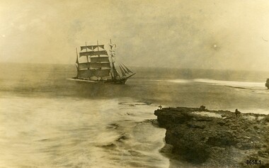
Postcard - Local Postcards, Joseph Jordan Photographic Studio, Nov 1908 - early 1909
ABOUT THE ‘FALLS OF HALLADALE’ (1886 - 1908) Built: in1886 by Russell & Co., Greenock shipyards, River Clyde, Scotland, UK. The company was founded in 1870 (or 1873) as a partnership between Joseph Russell (1834-1917), Anderson Rodger and William Todd Lithgow. During the period 1882-92 Russell & Co., they standardised designs, which sped up their building process so much that they were able to build 271 ships over that time. In 1886 they introduced a 3000 ton class of sailing vessel with auxiliary engines and brace halyard winches. In 1890 they broke the world output record. Owner: Falls Line, Wright, Breakenridge & Co, 111 Union Street, Glasgow, Scotland. Configuration: Four masted sailing ship; iron-hulled barque; iron masts, wire rigging, fore & aft lifting bridges. Size: Length 83.87m x Breadth 12.6m x Depth 7.23m, Gross tonnage 2085 ton Wrecked: the night of 14th November 1908, Curdies Inlet, Peterborough southwest Victoria Crew: 29 The Falls of Halladale was a four-masted sailing ship built-in 1886 in Glasgow, Scotland, for the long-distance cargo trade and was mostly used for Pacific grain trade. She was owned by Wright, Breakenridge & Co of Glasgow and was one of several Falls Line ships, all of which were named after waterfalls in Scotland. The lines flag was of red, blue and white vertical stripes. The Falls of Halladale had a sturdy construction built to carry maximum cargo and able to maintain full sail in heavy gales, one of the last of the ‘windjammers’ that sailed the Trade Route. She and her sister ship, the Falls of Garry, were the first ships in the world to include fore and aft lifting bridges. Previous to this, heavily loaded vessels could have heavy seas break along the full length of the deck, causing serious injury or even death to those on deck. The new, raised catwalk-type decking allowed the crew to move above the deck stormy conditions. This idea is still used today in the most modern tankers and cargo vessels and has proved to be an important step forward in the safety of men at sea. On 4th August 1908, with new sails, 29 crew, and 2800 tons of cargo, the Falls of Halladale left New York, bound for Melbourne and Sydney via the Cape of Good Hope. The cargo on board was valued at £35,000 and included 56,763 tiles of American slate roofing tiles (roof slates), 5,673 coils of barbed wire, 600 stoves, 500 sewing machines, 6,500 gallons of oil, 14,400 gallons of benzene, plumbing iron, 117 cases of crockery and glassware and many other manufactured items. The Falls of Halladale had been at sail for 102 days when, at 3 am on the night of 14th November 1908, under full sail in calm seas with a six knots breeze behind and misleading fog along the coast, the great vessel rose upon an ocean swell and settled on top of a submerged reef near Peterborough on south-west Victoria’s coast. The ship was jammed on the rocks and began filling with water. The crew launched the two lifeboats and all 29 crew landed safely on the beach over 4 miles away at the Bay of Islands. The postmistress at Peterborough, who kept a watch for vessels in distress, saw the stranding and sent out an alert to the local people. A rescue party went to the aid of the sailors and the Port Campbell rocket crew was dispatched, but the crew had all managed to reach shore safely by the time help arrived. The ship stayed in full sail on the rocky shelf for nearly two months, attracting hundreds of sightseers who watched her slowly disintegrate until the pounding seas and dynamiting by salvagers finally broke her back, and her remains disappeared back into deeper water. The valuable cargo was largely lost, despite two salvage attempts in 1908-09 and 1910. Further salvage operations were made from 1974-1986, during which time 22,000 slate tiles were recovered with the help of 14 oil drums to float them, plus personal artefacts, ship fittings, reams of paper and other items. The Court of Marine Inquiry in Melbourne ruled that the foundering of the ship was entirely due to Captain David Wood Thomson’s navigational error, not too technical failure of the Clyde-built ship. The shipwreck is a popular site for divers, about 300m offshore and in 3 – 15m of water. Some of the original cargo can be seen at the site, including pieces of roof slate and coils of barbed wire. These 5 postcards have photographic images taken while the Falls of Halladale was stuck on the reef near Peterborough. They are not stamped or dated but four of the images show the ship still in fairly good condition with her stern very low in the water so can be dated to around late November 1908 to January 1909 and the fifth image shows the ship beginning to disintegrate soon after. The image on Postcard 8658.3 was taken by Joseph Jordan (a well-known Warrnambool photographer who had his own studio in Liebig Street, Warrnambool). The other four images were supposedly taken by the sender (Bob) and converted to postcards. Amateur photography in Australia in the early 1900's was becoming very popular (and accessible) to the average person. Many newspapers published advertisements and articles about photography and photographic supplies. In 1903 in America, George Eastman designed and marketed the "Model 3A Folding Pocket Kodak" which used postcard-size negatives and provided the average person with a camera with which to make real photo postcards. As they became popular, George Eastman was able to develop and market a wide range of supplies for the amateur photographer to develop and print their own photographs onto a postcard backing at home. Four of the postcards were addressed to "Miss M. Kerr, Leura, Camperdown". Mary Agnes Kerr (1888 - 1943) was the daughter of William and Mary Ann Kerr (nee Spence) who owned "Leura Farm" at Camperdown. Mary Agnes Kerr went on to marry James Young Caldwell (a local tailor and mercer) in 1917. James Yong Caldwell came to Camperdown around 1908 and was employed as a draper. The postcards were signed "Bob". On postcard 5658.2 he has written his name with quotation marks around it - suggesting "Bob" is a nickname. He writes about the weather, meeting a friend, sending fish to Mary Agnes' family and the cargo expected to be washed up on the beach. On postcard 8658.4 he wrote about being busy after the wreck and supplying the shipwrecked crew with boots and pants which suggests "Bob" may be James Caldwell (the mercer and tailor).The Falls of Halladale shipwreck is listed on the Victorian Heritage Register (No. S255). She was one of the last ships to sail the Trade Routes. She is one of the first vessels to have fore and aft lifting bridges. She is an example of the remains of an International Cargo Ship and also represents aspects of Victoria’s shipping industry. The wreck is protected as a Historic Shipwreck under the Commonwealth Historic Shipwrecks Act (1976). These postcards are significant as examples of the continued interest the locals around the district of Peterborough showed towards the Falls of Halladale wreck and its disintegration during the next few months. Four of the postcards are also significant examples of the new hobby of photography that was available to the average person during the beginning of the 20th century.Set of 5 postcards showing different images of the Falls of Halladale sailing ship after it became stuck on a reef near Peterborough. None of the postcards are dated or stamped. Postcard 8658.1 has a sepia toned image of the Falls of Halladale, with its stern sitting very low in the water. It has many of its sails unfurled and there is a rocky headland in the foreground. A very small figure appears to be on the edge of the cliff. The back of the postcard has a handwritten message addressed to "Miss M Kerr, Leura, Camperdown" and is signed "Love Bob". Postcard 8658.2 has a sepia image of the Falls of Halladale taken some months after it had been stuck on the reef. Its sails are missing and only two broken masts remain. A large rock is visible in the front right hand side of the photo. There is a handwritten message on the back signed by "Bob". Postcard 8658.3 has a black and white image of the Falls of Halladale showing her almost side on with her stern very low in the water and still in full sail. The words "Falls of Halladale. No 1" are printed on the lower left side of the image. The back is labelled "Jordan Series". There is no message written on the back. Postcard 8658.4 has a sepia toned image of the Falls of Halladale facing two rocky headlands. She is showing full sail and the sea appears calm. There is a handwritten note on the back addressed to "Miss M Kerr" from "Bob". Postcard 8658.5 has a sepia image of a side view of the Falls of Halladale with her stern very low in the water and her sails are all up. The sea is calm and a rocky reef can be seen in the foreground. It has a handwritten note on the back from "Bob" to "Miss M Kerr" of Leura, Camperdown.Back of postcard 8658.1- "POST" "EMPIRE" "CARD" "FOR CORRESPONDENCE" "FOR ADDRESS ONLY" "STAMP" "Miss M Kerr / Leura / Camperdown" "Looking forward to letter today" "Hope fish arrived / allright. Don't / know for sure / what day I will / be going to Town / to buy. Some day / this week / Love Bob Back of postcard 8658.2 - "POST CARD"/ "CORRESPONDENCE" "ADDRESS ONLY" "93"/ "Friday / This is a contrast to the first/ I sent you. Having glorious weather / Saw Saw (Saul)? on Thursday at Peterborough / He is having a grand holiday / Expecting letter on /Tuesday Fondest Love / "Bob" Front of postcard 8658.3 - "Falls of Halladale. No 1" Back of postcard 8658.3 -"Post" "Card"/ Printed in Great Britain" /"This space may be used for Communication" "The Address to be written / here" "Jordan Series" Back of postcard 8658.4 -"POST" "EMPIRE" "CARD"/ "FOR CORRESPONDENCE" "FOR ADDRESS ONLY" / "STAMP" "Miss M Kerr/ Leura / Camperdown"/ "We are/ very busy. The / wreck is about / 11/2 other side of / Peterborough./ Fondest Love, Bob "Had to supply sailors with Boots Pants etc/ 25 pairs Boots, good order ah!" Back of postcard 8658.5 - "POST" "EMPIRE" "CARD" / "FOR CORRESPONDENCE" "FOR ADDRESS ONLY" / "STAMP"/ "Miss M Kerr / Leura / Camperdown" "Tuesday / Her estimated / value cargo included/ is (pounds)100,000. When / she breaks up the coast / will be strewn with / wreckage as the cargo / includes Rolls Paper./all sorts machinery thousands / cases Benzine etc/ love Bob flagstaff hill maritime museum and village, warrnambool, peterborough, great ocean road, falls of halladale, shipwreck, postcards, photographic images, mary agnes kerr, leura farm, camperdown, jordan series, handwritten notes, photographs, george eastman, 3a folding pocket kodak camera -
 Wodonga & District Historical Society Inc
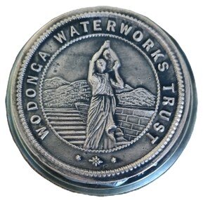
Functional object - Official Seal of the Wodonga Waterworks Trust
The Wodonga Waterworks Trust was established in 1897 to control and improve water supply to Wodonga. This included focus on the water quality which had often been a problem. After lobbying the Victorian Department of Water Supply for several years, the first official meeting of the officially constituted Wodonga Waterworks Trust was held on Wednesday 20th October 1897. The Board initially consisted of all Wodonga Shire Councillors together with Mr Samuel Mason Jr. as the nominee of the Government. Councillor McFarlane was appointed as the first Chairman. This seal was used to endorse all official documents issued by the Trust. Documents placed between the 2 plates of the seal would be embossed with the Trust’s emblem. This item is significant because it is representative of the first local government body constituted to improve water supply to Wodonga.A heavy metal seal machine used to make the imprint of the Wodonga Waterworks Trust. The seal is embossed on a circular disc. The imprint, which is not visible when assembled, show imprint of a woman in Grecian style clothes carrying a water ewer on her shoulder.Around circular seal - WODONGA WATERWORKS TRUSTwodonga waterworks trust, water supply wodonga -
 Wodonga & District Historical Society Inc
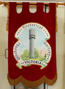
Banner - Wodonga Historical Society Banner, Betty L. Barberis, 2009
This item was created for Wodonga Historical Society by the artist, Betty L. Barberis in 2009. Betty Barberis nee Barton was one of 12 children born to Roderick Barton and Myrtle Ann Hore of Gundowring in the Kiewa Valley. She was born in 1927 and attended Upper Gundowring Primary School. Betty was encouraged to enter a project for the "Young Farmers" by illustrating a book. She won first prize for Victoria and the book was exhibited at the Royal Melbourne Show. This resulted in Betty attaining a Manual Art Teacher's Studentship which she completed at Wangaratta Technical School. Here she learned many new skills ranging from garment design to ceramics. She also attended Melbourne Teachers College. Betty created many decorative banners, the first being for the Australian section of the World Scout Jamboree in 1948. Over her long career she was to create many other banners and commissioned work, including this banner created for Wodonga Historical Society and featuring the Wodonga Water Tower. Betty’s great body of work included landscapes, millinery, ceramics, and a bronze sculpture of her husband Vern Barberis who was a fellow schoolteacher and represented Australia as a weightlifter, winning a bronze medal at the Helsinki Olympics in 1952. She also illustrated several books and had exhibitions in many galleries including in Albury. Betty passed away at The Grange, Wodonga on 26 November 2013.This banner was created by a renowned and highly regarded artist from Northeast Victoria.A large velvet banner created for the Wodonga Historical Society by noted local artist Betty L. Barberis. It is mounted on a pine rod and features an image of the water tower in Wodonga, Victoria. The majority of the banner is hand stitched.Around the edge of the central image: "Wodonga Historical Society Victoria.wodonga historical society, betty l. barberis -
 Warrnambool and District Historical Society Inc.
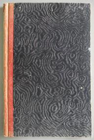
Journal - Diary, Diary of Augustus Bostock 1904-1907, Circa 1904
Augustus Bostock was the 9th child of Robert & Rachael Bostock of Vaucluse Epping Forest, Van Diemen’s Land. He was only 4 years old when his mother died. He was inspired by his father to seek his fortune in the Western District of Victoria. He arrived around 1850. He married Margaret Aitkin in July 1865. Augustus owned several properties in the district and leased others. He sat on the court of Warrnambool, Mortlake or Hexham as required. He resided at Marramook in Hawkesdale and later moved to Vaucluse in Hopetoun Road Warrnambool, where he died in 1920 at the age of 87. He was involved in many aspects of life in the Western District, racing, cricket, and social activities to name a few. This diary shows the daily entries over a long period of time with activities ranging from fencing, visiting neighbours and weather details. It mentions many local people and many properties he visited. Augustus Bostock along with a number of his brothers was one of the earliest pioneers in the Western District of Victoria. This diary sheds considerable light onto the life of Augustus and people of his era. There is a wealth of information on a range of topics relating to early life in Warrnambool and district.Cardboard cover, water- waved patterned in black and grey with orange cloth binding. Pages are all handwritten with dates in margin. Augustus Bostock Diary for 1904.diary of augustus bostock 1904-1907, warrnambool -
 Greensborough Historical Society
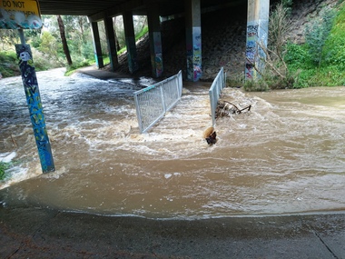
Photograph - Photograph - Digital Image, Marilyn Smith, Plenty River high water 2020, 24/08/2020
Digital images of high water in the Plenty River at Greensborough 24/08/2020. Part of a collection of miscellaneous historical images with a connection to the local area.7 Digital colour photographs of the Plenty River. plenty river, floods -
 Greensborough Historical Society
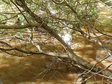
Photograph - Photograph - Digital Image, Marilyn Smith, Plenty River high water 2020, 24/08/2020
Digital images high water in the Plenty River at Greensborough 24/08/2020. Part of a collection of miscellaneous historical images with a connection to the local area.7 Digital colour photographs of the Plenty River. plenty river, floods -
 Clunes Museum
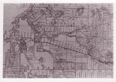
Document - MAP
... local history photography photographs water supply ...PHOTOCOPY OF CLUNES TOURELLO WATER SHED.local history, photography, photographs, water supply -
 Clunes Museum
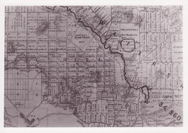
Document - MAP
... local history photography photographs water supply PHOTO ...PHOTO COPY. WATERSHED DAMS WEIR CREEK FOR THE COLLECTION OF WATER FOR THE CLUNES TOWNSHIP AND MINES.local history, photography, photographs, water supply -
 Clunes Museum
Document - MAP
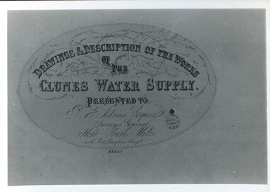
... local history photography photographs water supply DRAWINGS ...CLUNES WATER SUPPLY DRAWINGS & DESCRIPTIONS OF THE WORKS PRESENTED TO P.F. ADAMS ESQUIRE SURVEYOR GENERAL OF NEW SOUTH WALES WITH OCT. LANGHAMS COMP.DRAWINGS AND DESCRIPTIONS OF THE WORKS OF CLUNES WATER SUPPLY.local history, photography, photographs, water supply -
 Clunes Museum
Photograph, KODAK PRINT, FLOOD 1934, 1934
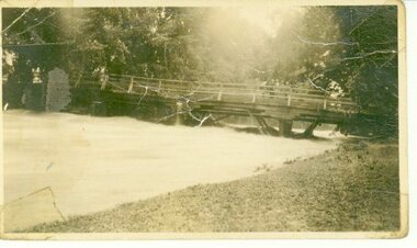
CRESWICK CREEK FLOODED IN 1934. AFTER VERY HEAVY RAINS UP STREAM - WATER REACHED SOLDIER'S MONUMENT AND BACK STREET.BLACK AND WHITE PHOTOGRAPH OF CRESWICK CREEK IN FLOOD. BUTTER FACTORY BRIDGE WITH WATER THREE QUARTERS UP PYLONS. 1934 FLOODS. TREES IN QUEEN'S PARK IN BACKGROUND.local history, photography, photographs, bridges -
 Clunes Museum
Photograph, FLOODS 1934
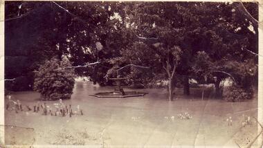
AFTER HEAVY RAINS - CRESWICK CREEK IN CLUNES TOWNSHIP FLOODED, OVER FLOWING ITS BANKS, NEAR BY AREAS WERE SUBMERGED.BLACK AND WHITE SMALL PHOTOGRAPH OF CLUNES FLOODS IN 1934. CLUNES QUEEN'S PARK WITH FOUNTAIN UNDER WATER - TREES IN THE BACKGROUND AND A FEW FLOWERS IN THE FOREGROUND.local history, queen's park garden., floods 1934 -
 Eltham District Historical Society Inc
Photograph - Digital Photograph, Alan King, Wycliffe Centre, Graham Road, Kangaroo Ground, 2008
Wycliffe translates the Bible for people around the world. Published: Nillumbik Now and Then / Marguerite Marshall 2008; photographs Alan King with Marguerite Marshall.; p171 The peace and beauty of Australia’s Wycliffe Centre reflects what it aims to bring to thousands of people around the world. Kangaroos calmly feed, accompanied by bird song, near the mud-brick buildings set amongst Kangaroo Ground’s rolling hills. On 11 hectares off Graham Road, the centre aims to transform people’s lives by giving groups around the world, with no written language, help with literacy and Bible translation into their own tongue. Associate Director, Harley Beck, says reading the Bible (probably history’s most influential collection of books), in one’s own language, provides a strong moral basis, helping people withstand exploitation and escape poverty. One of Wycliffe’s field partners, SIL (formerly Summer Institute of Linguistics) Papua New Guinea, has won two UNESCO awards, and SIL branches in many other countries have won international and national awards. The translators are modern heroes. They undertake hardships, forsaking for years, sometimes decades, a salary and the soft western lifestyle, to face loneliness and primitive conditions that most of us would not even contemplate. No staff is paid a salary. An example is the first Australian Director and former International President, David Cummings, who for 50 years has depended on donations from supporters and churches. Students of all ages at the EQUIP Training School on the site come from all walks of life. They train in linguistics and learn how to communicate in a way that is sensitive to other cultures. Spiritual resilience is encouraged, enabling people to persist until the job in the field is done, which takes on average ten to 15 years. Courses range from a few weeks to a year. The Wycliffe concept was born in the 1920s when American missionary, Cameron Townsend, found a Spanish Bible was inadequate to evangelise the Cakchiquel people of Guatemala. When a Cakchiquel man challenged: ‘If your God is so great, why doesn’t he speak my language?’ Townsend decided to translate the Bible into all languages! He founded a linguistics training school in 1934, naming it after 14th century theologian John Wycliffe, the first to translate the Bible into English. The first Wycliffe Bible was completed in 1951 in the Mexican San Miguel Mixtec language. In May 2007 after 30 years of work, Wycliffe Australia, with other organisations, completed the first Bible for indigenous people in the Kriol* language, for about 30,000 people in northern Australia. Wycliffe Australia began in 1954 in the Keswick Bookshop basement, Collins Street, Melbourne. As the organisation grew, its quarters became so cramped that Director Cummings at times interviewed potential recruits in his car! The development of the Kangaroo Ground property is a story of faith and generosity. In 1967 Cummings proposed moving to a larger property despite having no funds. Within a month Wycliffe received a $20,000 donation and a gift of land towards a national centre. An earlier owner of the Kangaroo Ground property, Mrs Elsie Graham, would have been delighted, as she had wanted her land to be used for ‘God’s service’. Mud-brick architect and Christian, Alistair Knox, offered to design the centre at no charge. Despite a drought, straw was donated to make bricks. Many volunteers helped with the building, including church youth groups who made mud-bricks. Volunteers planted thousands of native plants, watered by recycled water from the site’s dam. Building began in 1968 and in 1983 the South Pacific SIL School (now EQUIP Training) followed. Wycliffe, the world’s largest linguistic organisation, and other organisations, have translated the Scriptures into more than 2000 languages. But another 2000 languages still lack any portion of the Bible. However translations are now completed more quickly, because of new computer programs and as education spreads, more speakers of the local language can assist. Despite the growth of secularisation, Beck says support for Wycliffe Australia, which has offices in all states and the ACT, is stronger than ever. * Kriol is a Pidgin language, which has become a speech community’s prime language.This collection of almost 130 photos about places and people within the Shire of Nillumbik, an urban and rural municipality in Melbourne's north, contributes to an understanding of the history of the Shire. Published in 2008 immediately prior to the Black Saturday bushfires of February 7, 2009, it documents sites that were impacted, and in some cases destroyed by the fires. It includes photographs taken especially for the publication, creating a unique time capsule representing the Shire in the early 21st century. It remains the most recent comprehenesive publication devoted to the Shire's history connecting local residents to the past. nillumbik now and then (marshall-king) collection, graham road, kangaroo ground, wycliffe centre -
 Eltham District Historical Society Inc
Photograph - Digital Photograph, Alan King, Diamond Creek, Barak Bushlands, Eltham, 2008
A habitat corridor and it strengthens the community. Published: Nillumbik Now and Then / Marguerite Marshall 2008; photographs Alan King with Marguerite Marshall.; p185 Barak Bushlands lie west of the Diamond Creek on the corner of Falkiner Street and busy, noisy Main Road. They form part of an important habitat corridor linking the Yarra River to the Kinglake National Park.1 Manna Gums, tawny frogmouths and platypuses are some of the indigenous plants and animals that have made their home there. The bushlands are the result of more than nine years of hard work by the local community with the Nillumbik Council, to transform a degraded flood plain into this refuge of natural beauty. In 1997, shortly after moving into the new Riverside Estate on Falkiner Street, Eltham, several residents noticed the sorry state of the Diamond Creek and surrounding area. Part of it was used as a cow paddock and although small patches of vegetation survived, the area was infested with weeds, rabbits, rubbish and drainage from the housing estate. At various times the 4.4 hectares had been used as a market garden and for shire stock piles. The residents began to restore the area by revegetating land along the Diamond Creek. In 1998 they established the Friends of the Diamond Creek Falkiner Street Reserve2 and 35 families joined from the 90-house Estate. Carolyn Mellor, as the Friends’ Land Manager, undertook a four-year horticulture course to guide this massive project for a volunteer organisation. Since 1999, she has been the Friends’ President. In 1999 the Friends urged the Nillumbik Council to undertake a feasibility study into establishing a wetland system and urban forest. Work began in 2002 with Nillumbik Council funding the project, supplemented by government grants. The Friends also received grants from Melbourne Water and Parks Victoria. Aided by the Friends and other community members, the Council created the Barak Bushlands consisting of a forest, a wetland, a bridge, a path and open space. The beautiful wetland treats most of the estate’s stormwater runoff. Storm water is filtered through plants in the wetland ponds then is released slowly into the billabong, before flowing into the Diamond Creek. The wetland also helps to minimise flooding and the improved water quality provides a flora and fauna habitat. The Friends and other volunteers planted more than 27,000 plants, more than one third of which they grew from seeds they collected at Lower Eltham and Wingrove Parks. Eltham High School students planted thousands of these through a Year Eight program introduced for this purpose. Other groups who assisted were: Green Corps, local Scouts and Guides – 2nd Montmorency, 1st Diamond Creek and 1st Eltham Cub Packs, Eltham College students, Eltham East Primary School, Landcare members, Eltham Lions Club and the Eltham Baptist Church. To maintain enthusiasm for the mammoth task, the Friends and other volunteers ‘adopted’ trees to water and wrote their names on the stakes. In 2004, to recognise the area’s original occupiers, the reserve was named Barak Bushlands. William Barak, who lived from 1824 to 1903, was the last chief of the Yarra Yarra tribe of the Wurundjeri-willam people. Traces of these original inhabitants remain in scar trees (bark sections removed to make a shield or canoe). That same year the Friends’ group was a finalist in the prestigious Federal Government, Banksia Environmental Awards. The Friends have also participated in Clean Up Australia, removing tonnes of rubbish and regularly testing the billabong, wetland and creek, for pollutants. For years the Friends, together with the Australian Platypus Conservancy, have tagged, measured and checked the health of platypuses from the Diamond and Mullum Mullum Creeks. With Latrobe University the Friends have conducted night walks to view owls, possums, bats and sugar gliders. Challenges for the council and the Friends continue with a large rabbit population, some vandalism, weed eradication and maintenance. However, thanks to this community effort, locals can now escape confined urban living on small blocks of land and enjoy the beauty of indigenous plants and animals. Working together has also strengthened the local community,This collection of almost 130 photos about places and people within the Shire of Nillumbik, an urban and rural municipality in Melbourne's north, contributes to an understanding of the history of the Shire. Published in 2008 immediately prior to the Black Saturday bushfires of February 7, 2009, it documents sites that were impacted, and in some cases destroyed by the fires. It includes photographs taken especially for the publication, creating a unique time capsule representing the Shire in the early 21st century. It remains the most recent comprehenesive publication devoted to the Shire's history connecting local residents to the past. nillumbik now and then (marshall-king) collection, barak bushlands, diamond creek (creek), eltham -
 Warrnambool and District Historical Society Inc.
Journal - Diary, Diary of Augustus Bostock 1890, Circa 1890
Augustus Bostock was the 9th child of Robert & Rachael Bostock of Vaucluse Epping Forest, Van Diemen’s Land. He was only 4 years old when his mother died. He was inspired by his father to seek his fortune in the Western District of Victoria. He arrived around 1850. He married Margaret Aitkin in July 1865. Augustus owned several properties in the district and leased others. He sat on the court of Warrnambool, Mortlake or Hexham as required. He resided at Marramook in Hawkesdale and later moved to Vaucluse in Hopetoun Road Warrnambool, where he died in 1920 at the age of 87. He was involved in many aspects of life in the Western District, racing, cricket, and social activities to name a few. This diary shows the daily entries over a long period of time with activities ranging from fencing, visiting neighbours and weather details. It mentions many local people and many properties he visited. Augustus Bostock along with a number of his brothers was one of the earliest pioneers in the Western District of Victoria. This diary sheds considerable light onto the life of Augustus and people of his era. There is a wealth of information on a range of topics relating to early life in Warrnambool and district.Blue cloth, water wave cover with maroon binding.Maroon, blue and white patterned pages inside front and back covers. Pages are all handwritten. Coomete 1890.diary of augustus bostock 1890, warrnambool -
 Lakes Entrance Regional Historical Society (operating as Lakes Entrance History Centre & Museum)
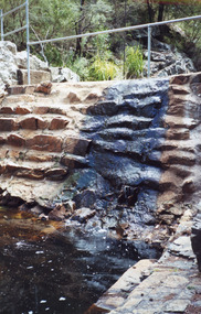
Photograph - Costick's Weir, 1999
Built 1942 - 43 to ensure as adequate water supply for fire fighting purposes, after the devastation of the 1939 forest fires. Used by locals as a swimming pool until flooding in the 1980's filled the weir with silt.Colour photograph of Costicks Weir, Old Colquhoun Road, Colquhoun Forest. Shows manmade dam in bush setting. Constructed by building a weir wall across a small natural gorge. Nowa Nowa Victoriavegetation, weir's, local history -
 Flagstaff Hill Maritime Museum and Village
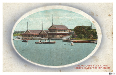
Postcard - Historical, Warrnambool, Proudfoot’s Boat House, Hopkins River, Warrnambool, Early 20th century
The nine postcards in this set were donated together and date to the early 1900s. All but one postcard in this set shows images of Warrnambool, in the Western District of Victoria; the other has a London image. The postcards were all printed in Great Britain according to that country’s postal regulations. All cards have titles on the front printed in red. The majority of the images on the cards are attributed to photographer Joseph Jordan and belong to the Jordan Series. The back of these cards has an outline for a postage stamp, a vertical dividing line and a heading on each side of the line to separate the Correspondence from the Address. Postcards or ‘correspondence cards’ appeared in Britain in 1894. They were plain cards with a space for the message on one side and an address on the other; regulations didn’t allow anything but the address to be written on the ‘address’ side. In 1902 the British regulations then allowed a picture to be printed on the front and the address on the back, so messages had to be written on the picture side. Soon, the regulations changed and the back was divided for a message and the address. Proudfoots Boat House – Proudfoot’s Boathouse is at 2 Simpson Street Warrnambool, on the banks of the Hopkins River. In the 1880s it was a venue for hiring boats for rowing, fishing, sailing and picnics. It was a popular destination for tourists coming from Melbourne for a day or weekend outing. The beautiful historic Victorian period building was designed, built and established by Thomas Proudfoot. He applied to build a boat jetty in 1885. He died in 1900 and his wife Catherine took over, running it for many years. Later her son Bruce and after that her granddaughter Ena Hunt and her husband took over; it remained in the family until 1979. The buildings, including the ‘U’ shaped jetty and tearooms, were restored and modified in the 1990s by the Warrnambool Sports Club, under the control of the Warrnambool City Council. Joseph Jordan - Joseph Jordan was born in 1841 in Leicester England. When he was 16 he joined the 7th Queen's Own Hussars and was sent to India at the outbreak of the mutiny. He took part in the relief of Lucknow and remained in India for eleven years. It was during this time, he became interested in photography. He was posted to New Zealand and later came to Victoria, becoming a sergeant major of the Mounted Rifles. In the mid-1880s he came to the Western district where he was responsible for establishing units of the Mounted Rifles in various country towns such as Dunkeld, Mortlake, Panmure, Bushfield, Koroit etc. He resigned from the army in 1889 and set up a professional photography studio in Liebig Street, Warrnambool. He became very well known in the Western District for family photographs, official photographs of local councillors and groups as well as views of local scenery. In 1891 he photographed the wrecked barque ‘Fiji’ at ‘Wrecks Beach’ near Princetown. His business was taken over by his son Arthur around 1917. Joseph was a keen rifle shot and in 1924 he donated the "Jordan Shield" as a prize to the Victorian Rifle Association. He was made a "Life Honorary Member" of the Warrnambool Returned Soldiers League and in 1933 he was recognised as being the oldest living soldier in Victoria. Joseph died in 1935 aged 95.This card is the only one of the nine cards with the location of Warrnambool added to the name 'Joseph Series'. It is also the only one that has text within the outline for the postage stamp. The font used for the test of the headings is slightly different to the other cards. Joseph Jordan is a significant figure in Warrnambool history as he helped to establish early units of the Mounted Rifles (G Company) in local towns during the late 1880's and later, photographed local scenes, groups and citizens of early Warrnambool. This postcard of Proudfoot's Boathouse is of historical significance for is connection with Proudfood’s Boathouse. Proudfoot’s Boathouse is an example of late-Victorian recreational and tourist facilities. Boathouses were popular 19th-century tourist and recreational attractions, providing refined and healthy activity. This boathouse shows the early realisation of the tourism and leisure potential of seaside towns such as Warrnambool, a potential that has become increasingly important as port uses have ceased and other industries have been subjected to financial pressure. Proudfoot's Boathouse is of social significance because it illustrates the continuity of the attraction of this kind of leisure facility. Although the glory days of boathouses were in the 19th century, those that survive continue to be well patronised. Proudfoot's Boathouse has been an important recreational facility and attraction for tourists flocking to the Hopkins River, one of the State's most popular boating and fishing resorts, since 1885.” (Statement of Significance is from the Victorian Heritage Register)Postcard, one of nine, landscape orientation. Coloured photograph print within an oval border and mauve-toned shading. Cameo Image of figures in three rowing boats on still water beside a building with three gable roofs and decorative verandas. Other boats are moored at the landing in front of the building. The roofs each have a tall pole at the front. There is a park right of the building that also has a landing. In the background is a grassed slope and the sea. Reverse has printed inscriptions and an outline for a postage stamp. There is no correspondence written on the card. The card is one of the Jordan Series by Joseph Jordan, printed in Great Britain in the early 1900s. Front, in red: “PROUDFOOT’S BOAT HOUSE / HOPKINS RIVER, WARRNAMBOOL” Reverse in black: “Jordan Series Warrnambool” “POST CARD” “Printed in Great Britain” “This space may be used for Communication” “The Address to be written here” Within the stamp outline: “3 / BRITISH / MANUFACTURE"flagstaff hill maritime museum, flagstaff hill maritime village, flagstaff hill maritime museum and village, maritime museum, warrnambool, great ocean road, warrnambool and district, warrnambool scenes, local scenes, views of warrnambool, joseph jordan, jordan series, jordan photography, postcard, souvenir, correspondence, cameo postcard, landscape, proudfoots boat house, boat house, proudfoots, hopkins river, boats for hire, row boats, recreation -
 Flagstaff Hill Maritime Museum and Village
Postcard - Historical, maritime, Breakwater, Warrnambool, ca. 1890
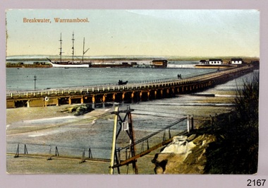
The local photograph shows the original footbridge across the Merri River near its mouth, the Viaduct road and the Warrnambool Breakwater with the Titan crane on it. The breakwater's construction was completed in 1890, the year this photograph was taken. The Viaduct has since been filled in to prevent water from passing through the pylons, and the footbridge has been replaced. The postcard has a personal message written on the back to a Dr Scott from May. The photograph is locally significant for recording the completion of the Warrnambool Breakwater, for showing the original design of the Viaduct and for a clear view of the original footbridge across the Merri River. It is also of significance for being used by a female to send a greeting from Warrnambool to a doctor. Postcard, coloured, of the Warrnambool Breakwater, with the Merri River footbridge and the Viaduct in the foreground. Pedestrians and a horse-drawn cart are on the Viaduct, The lifeboat house and other buildings are near the beginning of the Breakwater. A three-masted sailing ship is in port. The photograph was taken from Middle Island. A personal message is written on the back, and a title is printed on the front. Produced in Germany in the 1890s.On the front: "Breakwater, Warrnambool" Written on the reverse: "Warrnambool Wishing Dear Dr Scott the Compliments of the Season With love and best wishes, From May"warrnambool, shipwreck coast, flagstaff hill, flagstaff hill maritime museum, flagstaff hill maritime village, postcard, coloured postcard, warrnambool breakwater, breakwater, viaduct, 1890s, merri river footbridge, dr scott, may -
 Lakes Entrance Regional Historical Society (operating as Lakes Entrance History Centre & Museum)
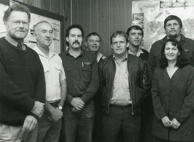
Photograph - Tambo Water Board, Lakes Post Newspaper, 1993
... Water Resources Local Government Black and White Photograph ...Black and White Photograph of Seven members of Tambo Water Board , John Hitchison, , Alf Coleman, Wayne Stewart, Brian White, Gerry Thorn, Tim Froud, Tony McKean, Marlene Battista 1996 Lakes Entrance Victoriawater resources, local government