Showing 855 items matching "parish plan"
-
 Bendigo Historical Society Inc.
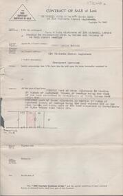
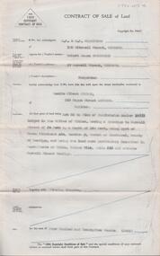
Document - H. A. & S. R. WILKINSON COLLECTION: CONTRACT OF SALE
Contract of sale of land by public auction dated 17th March 1956 between Mr. Kevin Daniel Bourke (vendor) and Ms. Evelyn Mary Pook (purchaser). Solicitor for vendor: Hogan & Hogan, Bendigo. Solicitor for purchaser: Hyett, Willis & Hyett, Bendigo. Property: 112 Victoria Street, Eaglehawk being land firstly part of Crown allotment 11 section 17 Parish of Eaglehawk land described in certificate of title volume 2467 folio 304. Secondly part of Crown allotment 10 section 17 Parish of Eaglehawk, land coloured red on the plan hereon being part of land comprised in certificate of title volume 4416 folio 036. Price 1,100 pounds.organization, business, h.a. & s.r wilkinson real estate -
 Bendigo Historical Society Inc.
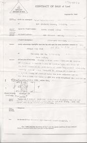
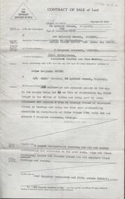
Document - H. A. & S. R. WILKINSON COLLECTION: CONTRACT OF SALE
Contract of sale of land dated 31st May 1956 between Mr. Kevin Daniel Bourke (vendor) and Ms. Evelyn Mary Pook (purchaser). Solicitor for vendor: Hogan & Hogan, Bendigo. Solicitor for purchaser: Hyett, Willis & Hyett, Bendigo. Property: 112 Victoria Street, Eaglehawk being land firstly part of Crown allotment 11 section 17 Parish of Eaglehawk land described in certificate of title volume 2467 folio 304. Secondly part of Crown allotment 10 section 17 Parish of Eaglehawk, land coloured red on the plan hereon being part of land comprised in certificate of title volume 4416 folio 036. Price 1,100 pounds. Photocopy of office copy.organization, business, h.a. & s.r wilkinson real estate -
 Bendigo Historical Society Inc.
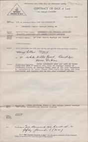
Document - H. A. & S. R. WILKINSON COLLECTION: CONTRACT OF SALE
Contract of sale of land dated 24th February, 1956 between Mrs. D. I. Smith (vendor) and Mr. A. W. & Mrs. N. Pulfer (purchaser). Solicitor for vendor: E. C. Cohen. Solicitor for purchaser: Hyett, Willis & Hyett. Property: land being lot 13on plan of subdivision No. 21180 lodged in the office of titles, being part of Crown allotment 457 section H Parish of Sandhurst described in certificate of title volume7793 folio 150 and situate No. 3 Margaret Crescent, Bendigo, together with brick veneer dwelling and all sundry. Price: 5,500 pounds.organization, business, h.a. & s.r wilkinson real estate -
 Bendigo Historical Society Inc.
Document - H. A. & S. R. WILKINSON COLLECTION: CONTRACT OF SALE
Contract of sale of land dated 12th July 1955 between Mr. C. Naismith (vendor) and Mr. J. M. Parsons (purchaser). Property: land being lot 20 on plan of subdivision No. 22101 part of Crown allotment 60 section D Parish of Mandurang, County of Bendigo and being land described in certificate of title volume 7925 folio 69 and situate Archer Street, Kangaroo Flat. Price: 140 pounds.organization, business, h.a. & s.r wilkinson real estate -
 Bendigo Historical Society Inc.
Document - H. A. & S. R. WILKINSON COLLECTION: CONTRACT OF SALE
Contract of sale of land dated 9th February 1955 between Mr. R. J. Sanderson (vendor) and Mr. L. A. Pitson (purchaser). Property: Lot 55 on plan of subdivision No. 16998 lodged in the office of titles, having a frontage to Burrell Street of 50 feet by a depth of 140 feet, being part of Crown allotment 432 section H Parish of Sandhurst County of Bendigo, land described in certificate of title volume 7314 folio 636 and situate Burrell Street, Bendigo, together with the fencing thereon. Price: 425 pounds.organization, business, h.a. & s.r wilkinson real estate -
 Bendigo Historical Society Inc.
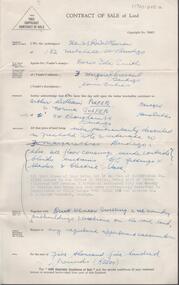
Document - H. A. & S. R. WILKINSON COLLECTION: CONTRACT OF SALE
Contract of sale of land dated 12th January, 1955n Mr. L. W. & Mrs. L. M. Dennis (vendor) and Mrs. A. M. Praetz (purchaser). Property: land delineated and coloured purple on the map in the margin being lot 11 on plan of subdivision 21180 lodged in the office of titles being part of Crown allotment 457 section H Parish of Sandhurst, City of Bendigo, land described in certificate of title volume 7793 folio 149 and situate 7 Margaret Crescent, Bendigo, together with 5 rooms weatherboard dwelling and all sundry buildings on said land, also all floor coverings, blinds and electric light fittings and shades. Price: 4,150 pounds.organization, business, h.a. & s.r wilkinson real estate -
 Bendigo Historical Society Inc.
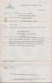
Document - H. A. & S. R. WILKINSON COLLECTION: CONTRACT OF SALE
Contract of sale of land dated 20th January, 1956 between Sandhurst & Northern District Trustees Executors& Agency (vendor) and Mrs. M. E. Taylor (purchaser). Property: land being Crown allotment 9 and part of Crown allotment 9A section 55C Parish of Sandhurst city of Bendigo, land described in certificate of title volume 4258 folio 516 land coloured red on the plan endorsed hereon, together with brick dwelling known as 199 Bridge Street, Bendigo. Price: 2,650 Pounds.organization, business, h.a. & s.r wilkinson real estate -
 Bendigo Historical Society Inc.
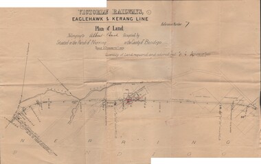
Document - BUSH COLLECTION: PLANS PERTAINING TO LAND OF S. A. BUSH
A: Plan of subdivision of Allots 6, 7, 8, 15 & 16, Sec. 62C, City of Bendigo (The Property of Albert Bush, Esq.) - Plan is torn in half forming two pieces (see 'Condition'. Pinned note attached to one piece. B: Victoria Railways, Eaglehawk & Kerang Line (Albert Bush land, Parish of Nerring, County of Bendigo.person, individual, bush collection - personal -
 Bendigo Historical Society Inc.
Document - INDEXES
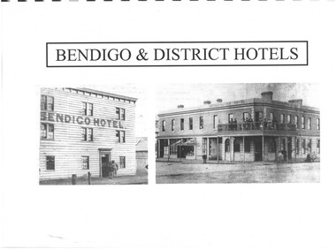
... 1965-1987 Plans of townships and Parishes held at Ducley House... 1965-1987 Plans of townships and Parishes held at Ducley House ...Indexes Includes Names from the 1856 Petition Bendigo and District Hotels Final Marunari List Terry Davidson 1871 - 2018 Index to RHSV Bendigo Branch Newsletters Nov. 1971 - July 2002 Helen Mainka 1954 Bendigo Business District Directory McConnell’s Street and general Directory Date unknown Victorian Directory 1904 Bendigo and District Directory 1904 – 1905 Bendigo district general Directory 1859 City of Bendigo Historical Information Bendigo Hotels compiled by Len Bennetts Hotels of Bendigo and District Compiled by Len Bennetts Sandhurst Land Sales 1854 – 1856 Ralph Birrell Chronicles of Bendigo from the Bendigo Advertiser Christmas Supplement December 22 1904 Some Photographers 1850 – 1900. Including some Bendigo Photographers 1854 – 1958 St. Patrick’s Annual Sports advertisers. Date Unknown Fatalities listed in bendigo Advertiser 1888-1935. Two copies One by year. One alphabetical. District statistics - Mayors and Shire Presidents, Bendigo Football League Premiers 1880- 1987, Sportstar of the year 1965-1987 Plans of townships and Parishes held at Ducley House. From the Bendigo Lands Office 1976. -
 Bendigo Historical Society Inc.
Document - PLANS FROM LAND OFFICE , BENDIGO
Royal Historical Society of Victoria Bendigo and district branch. Plans from Land office, Bendigo. Four pages listing of parishes and two pages listing of Township plans. -
 Bendigo Historical Society Inc.
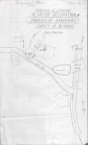
Photograph - DIAMOND HILL 1936, PLAN OF OCCUPATION
... parish of Sandhurst, County of Bendigo' Plan shows Post Office..., plan of occupation parish of Sandhurst, County of Bendigo' Plan ...Print of 'Application of J. Hattam, plan of occupation parish of Sandhurst, County of Bendigo' Plan shows Post Office site, large dam, 'formerly cultivated site near Post Office'. A un-named gully is marked.bendigo, mining, diamond hill -
 Bendigo Historical Society Inc.
Map - HUSTLER'S & CHRISTMAS LINES OF REEFS - PLAN OF LINES OF SECTION OF REEFS
Underground Survey of Mines Bendigo. Plan of Cross Section Lines Shewing Connections with Trigonometrical Stations and Base Lines. 13/3/99 Signed ? Stirling. Places and mines mentioned Speciman Hill, Tambour Major, Lansell's 180, Victory and Pandora, Great Extended Hustler's, Windmill Hill on Victoria Reef. Next part of map is a Plan of Lines of Section between the Hustler's and Christmas Lines of Reefs. 8/3/99. Signed ?. Transverse Section. Shows Tambour Major Co., near the Christmas Line of Reef, Crosscuts and their depth, geological features and stone encountered. Then shows Thistle Line, Charshalton Line, Napoleon Line, Nell Gwynne Line, New Chum Line, Lansell's No 180 with levels, depths and geological features. Drawing is continued in three parts to fit on paper. Lansell's East Shaft with levels and depths, geological features and stone encountered. Sheepshead Line, Old Shaft, Garden Gully Line, Victory and Pabndora Co with crosscuts, depths, geological features and stone encountered. Paddy's Gully Line, Derby Line, Millers Line, Hustler's Line, Great Extended Hustler's Co with levels, depths, geological features and stone encountered. A note beside a Saddle Reef: 360,000 pounds paid in dividends from this reef. Average ounces per ton gold noted where found. Reference Table for stone and geological features. Datum Line 700 feet above Sea Level Unscannedmining, parish map, hustler's & christmas lines of reefs, plan of lines of section of reefs, ? stirling, specimen hill, tambour major, lansell's 180, victory & pandora, great extended hustler's, windmill hill, victoria reef, tambour major co, christmas line, hustler's line, thistle line, carshalton line, napoleon line, nell gwynne line, new chum line, lansell's no 180, lansell's east shaft, sheepshead line, old shaft, garden gully line, paddy's gully line, derby line, miller's line, hustler's line, great extended hustler's co -
Bendigo Historical Society Inc.
Map - CAMPBELL COLLECTION: BENDIGO AND DISTRICT MAPS, 6-4-28
Map. Sedgwick, Parishes of Strathfieldsaye, Lyell, and Sedgwick. Scale 20 chains to 1 inch. Total area 5372 acres. Prepared in W.P.B. from C.L.and A. Plans by W.J.Galbraith 6-4-28. (number 400 in map cupboard 1)W.J.Galbraith.map, bendigo, agricultural lands -
Port Melbourne Historical & Preservation Society
Map - Port Melbourne, Department of Lands and Survey, 20 Sep 1932
Dept. of Lands and Survey Map Sheet 5 Port Melbourne, Parish of South Melbourne.Annotated re MHT precincts on foreshore:Plan sketches re boat harbourtown planning, sandridge lagoon, melbourne harbor trust - port of melbourne authority, transport - railways -
Port Melbourne Historical & Preservation Society
Plan - Port Melbourne, 1882
... Large, deteriorated 1882 plan of Port Melbourne, Parish... Large, deteriorated 1882 plan of Port Melbourne, Parish of South ...Large, deteriorated 1882 plan of Port Melbourne, Parish of South Melbourne, County of Bourke - showing Town Lots. Pasted onto board.town planning, fishermans bend, sandridge lagoon, transport - railways -
 Bendigo Historical Society Inc.
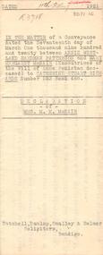
Document - JOHANSON COLLECTION: MORTGAGE MRS CATHERINE STUART RICHARDS
In the matter of a Conveyance dated the Seventeenth day of March one Thousand Nine Hundred and Twenty between Annjie Westland Hardman Patterson, Mary Margaret McNair, executrices of the Will of Annie Penistan deceased) to Catherine Stuart Richards Number 523 Book 488. Declaration of mrs. M. M. McNair. Tatchell, Dunlop, Smalley & Balmer Solicitors Bendigo. Subdivision Plan Of Allotment No. 10, Sec: 80,C. City of Bendigo, parish of Sandhurst, County of Bendigo.bendigo, house, patterson, mcnair, richards, annie westland hardman patterson, may margaret mcnair, catherine stuart richards. tatchell, dunlop, smalley & balmer solicitors bendigo. -
 Bendigo Historical Society Inc.
Document - CROWN ALLOTMENT 406A (PLAN) JOSS HOUSE
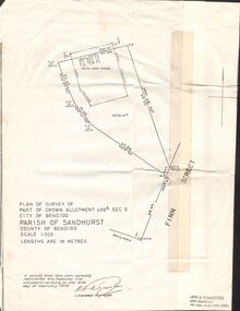
Plan of Survey of part of Crown Allotment 406A Sec E. City of Bendigo. Parish of Sandhurst. County of Bendigo. Scale 1:500. (Copy of Original). As at 21 February 1979. This survey shows the location of the Joss House and the portion of land where it is located.plan, bendigo, joss house, crown allotment 406a (plan), joss house -
 Bendigo Historical Society Inc.
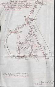
Plan - MCCOLL, RANKIN AND STANISTREET COLLECTION: PLAN OF SURVEY OF DAM SITE, 1941
McColl Rankin & Stanistreet, Plan of Survey of Dam site, Part of Crown Allotment 98 Section C, City of Bendigo, Parish of Sandhurst, County of Bendigo. Signed by Garnet G Birch 1 Feb 1941. 33.5 x 43. Attached is a Copy of Field notes, Dam Site in Crown Allotment 198 Sec. City of Bendigo, Parish of Sandhurst. True Meridian, County of Bendigo, Area 0A 1R 16P. Signed Garnet G Birch, 1/2/1941. Drawn in red and black pen. 20.8 x 33. Both maps are for Deborah Extended Gold Mining Co. No Liabilityorganization, mining, deborah extended gold mining co nl, mccoll rankin & stanistreet, plan of survey of dam site -
Bendigo Historical Society Inc.
Map - BENDIGO IRRIGATION SETTLEMENT, 12/02/1908
Map: Plan of Bendigo Irrigation Settlement, Parishes of Sandhurst and Wellsford, County of Bendigo ( number 160 in Map Cupboard 1)map, bendigo, irrigation settlement, bendigo irrigation settlement, parishes of sandhurst and wellsford, county of bendigo -
 Bendigo Historical Society Inc.
Document - MCCOLL, RANKIN AND STANISTREET COLLECTION: ANGOVE AND CARRS LEASE, DIAMOND HILL, 1935
McColl Rankin & Stanistreet, Angove & Carrs Lease, Diamond Hill. a/ Manila folio Markings: Angove & Carrs Lease Diamond Hill. Freed?aus Extended. b/ Plan Area Applied For On Lease No. 10103 Ben. By A A Macintosh. Mining District of Bendigo Parish of Mandurang County of Bendigo. Inscriptions: G Birch advises 16/5/35. Survey made by Assistant he has yet to receive. 10710 W J Angove - Spring Gully PO. Dated August 12th 1933 signed: Garnet G Birch J Victor Buley. c/ Agreement of lease for 1 month with the option of 9 months, followed by the option of purchase between Summerhill Anticlines NL of Adelaide and Angove & Carr at German Gully (Mandurang). Markings: 25/3/13 note by Summerhill Anticline NL. Requests information as to whether or not the Syndicate (E Mann, W Angove & H Irvine, H. Mc……….) desire to take up the options of lease or not. d/ Notice to Shareholders of a meeting in Collins Street Melbourne. 6 March, 1935 to consider proposals of the future of the company. J G Stanfield & Stewart, Manager. e/ Neangar Gold Mining Company NL 6 Month Report 27/2/1935 Business, Director's Report & Financial Report. f/ Report by A J J Moore BCE Mining Engineer, Ramrod Lease, Golden Fleece Mine near Spring Gully Reservoir the most Southern mine being Worked in Bendigo. Lease in on the Carshalton line. Report details the progress of the workings at the mine.organization, business, gold mine, mccoll rankin & stanistreet, angove & carrs lease, diamond hill a a macintosh parish of mandurang county of bendigo w j angove august 12th 1933 summerhill anticlines 6 month report 27/2/1935 golden fleece mine near spring gully reservoir -
 Bendigo Historical Society Inc.
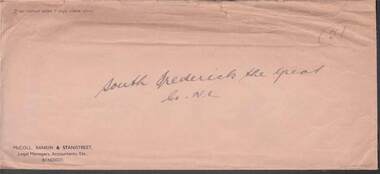
Document - MCCOLL, RANKIN AND STANISTREET COLLECTION: SOUTH FREDERICK THE GREAT CO NL, 1934
McColl Rankin & Stanistreet, South Frederick the Great Co NL. a/ Plan of Residence Areas on No. 10287, by J O Charlton, Parish of Yarraberb. Includes land for school, owners names of blocks, crown land. Signed: Garnet G Birch. Dated 27/4/1935, licensed surveyor. b/ Letter from Department of Mines to McColl Rankin & Stanistreet in reference to letter regarding lease No. 10287. On back of letter are notes relating to blocks of land on lease No.10287. c/ Plan Of Area For On Lease No. 10287 Ben. By John O Charlton. Mining District of Bendigo, Parish of Yarraberb, Lease No. 10287 Ben. By John O Charlton. Mining District of Bendigo. Date 21/6/1934. Signed Garnet G Birch. Blocks include name of purchaser. d/ Plan Of Area For On Lease No. 10287 Ben. By John O Charlton. Mining District of Bendigo, Parish of Yarraberb, County of Bendigo. Dated 21/6/1934. e/ envelope inscribed South Fredrick the Great. 51.organization, business, gold mine, plan of area for on lease no. 10287 ben. by john o charlton. mining district of bendigo, parish of yarraberb, county of bendigo j o charlton garnet g birch department of mines lease no. 10287 ben. by john o charlton mining district of bendigo 1934 -
Bendigo Historical Society Inc.
Map - COUNTY OF BENDIGO, No date visible
Map. Plan showing all of the Parishes in the County of Bendigo (number 342 in map cupboard 1)map, bendigo, parishes, county of bendigo -
 St Kilda Historical Society
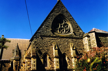
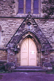
Photograph, Christ Church St Kilda exterior - images collection #1
Christ Church was constructed in 1854-57 and designed in Decorated Gothic style by Albert Purchase & Charles Swyer. It was enlarged in 1874 and 1881 to the designs of Sydney W Smith. It is one of four main buildings constructed on land granted to the Church of England in 1855 and named Church Square. The other buildings are the bishop's residence, vicarage and parish hall. Heritage Victoria describes it as a 'rare and significant square in the history of town planning in Victoria which demonstrates the importance of the church to the community'. It is built from rarely used undressed random coursed sandstone from Point King Sorrento. It is located at 14 Acland Street, St Kilda. The triangular rose window is said to have been modelled on Lichfield Cathedral and shows outstanding craftsmanship. According to Heritage Victoria, the only other known example in Victoria is at St Georges Presbyterian Church in East St Kilda, designed by the same architect, Albert Purchas.colour photograph unmountedrose window, acland street, purchase, swyer, st kilda, christ church -
 St Kilda Historical Society
Photograph, 26/11/1978
Image taken on a bus trip, 26 November 1978. Christ Church was constructed in 1854-57 and designed in Decorated Gothic style by Albert Purchase & Charles Swyer. It was enlarged in 1874 and 1881 to the designs of Sydney W Smith. It is one of four main buildings constructed on land granted to the Church of England in 1855 and named Church Square. The other buildings are the bishop's residence, vicarage and parish hall. Heritage Victoria describes it as a 'rare and significant square in the history of town planning in Victoria which demonstrates the importance of the church to the community'. It is built from rarely used undressed random coursed sandstone from Point King Sorrento. It is located at 14 Acland Street, St Kilda. The triangular rose window is said to have been modelled on Lichfield Cathedral and shows outstanding craftsmanship. According to Heritage Victoria, the only other known example in Victoria is at St Georges Presbyterian Church in East St Kilda, designed by the same architect, Albert Purchas.colour photograph polaroidSKHS Bus trip 26/11/78 Christ Churchrose window, acland street, purchase, swyer, st kilda, christ church, churches -
 St Kilda Historical Society
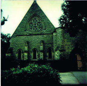
Photograph, Christ Church St Kilda exterior - images collection #2
Christ Church was constructed in 1854-57 and designed in Decorated Gothic style by Albert Purchase & Charles Swyer. It was enlarged in 1874 and 1881 to the designs of Sydney W Smith. It is one of four main buildings constructed on land granted to the Church of England in 1855 and named Church Square. The other buildings are the bishop's residence, vicarage and parish hall. Heritage Victoria describes it as a 'rare and significant square in the history of town planning in Victoria which demonstrates the importance of the church to the community'. It is built from rarely used undressed random coursed sandstone from Point King Sorrento. It is located at 14 Acland Street, St Kilda. The triangular rose window is said to have been modelled on Lichfield Cathedral and shows outstanding craftsmanship. According to Heritage Victoria, the only other known example in Victoria is at St Georges Presbyterian Church in East St Kilda, designed by the same architect, Albert Purchas. The Church has a varied collection of stained glass, including work by leading stained glass firms and artists in Victoria in the nineteenth and early twentieth century: Ferguson & Urie, William Montgomery and Brooks Robinson. The 'shipwreck window,' north west transept, is an historically significant memorial window dedicated to Miles and William Dalzell Nicholson, the second and third sons of the Hon. William Nicholson, M.L.A, a Lord Mayor of Melbourne and Premier of Victoria in the 1850s. Miles, died in England on 27 April 1874. His younger brother William died in the wreck of the ‘British Admiral’ off King Island on 23 May 1874. The images show the condition of the church at the time they were taken (c 2012). Signs of deterioration can be seen. The bell is not rung any more because of damage to the stonework.There has been some remedial work since and the National Trust of Australia conducted a heritage restoration appeal.churches, acland street, purchase, swyer, st kilda, christ church -
 St Kilda Historical Society
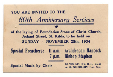
Ephemera - Invitation, 80th Anniversary Services, 1934
Invitation to services commemorating the 80th anniversary of the laying of the foundation stone of Christ Church, at 14 Acland Street St Kilda, on 25 November 1934. Christ Church was constructed in 1854-57 and designed in Decorated Gothic style by Albert Purchase & Charles Swyer. It was enlarged in 1874 and 1881 to the designs of Sydney W Smith. It is one of four main buildings constructed on land granted to the Church of England in 1855 and named Church Square. The other buildings are the bishop's residence, vicarage and parish hall. Heritage Victoria describes it as a 'rare and significant square in the history of town planning in Victoria which demonstrates the importance of the church to the community'. It is built from rarely used undressed random coursed sandstone from Point King Sorrento. White card, discoloured with aged, printed in dark blue on one side.christ church, acland street -
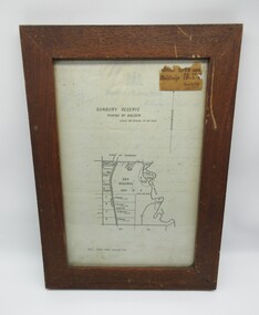 Hume City Civic Collection
Plans, SUNBURY RESERVE PARISH OF HOLDEN
... recreation ground. SUNBURY RESERVE PARISH OF HOLDEN Plans ...This object is a plan of a proposed recreation ground at Munro's. This was unfenced land between Evans and Barkly Streets adjacent to the Asylum boundary, now Jacksons Hill.A wooden framed plan of a proposed recreation ground.sunbury, sunbury asylum, george evans collection -
Stawell Historical Society Inc
Map, R.O. Robson - Authorised Surveyor, Road from Glenorchy to near Geary's Selection Callawaddy 1880, 29.04.1880
Survey for Road CreationCloth Backed Map. Plan of Road.Parishes of Richella & Callawadda. County of Borong. Plan of Road. R.O. Robson Authorised Surveyor Stawell 29.04.80 -
Whitehorse Historical Society Inc.
Map, A Plan of part of the Parish of Nunawading, 1984
Hand drawn plan showing the owners or occupiers of land c1860'.Hand drawn plan showing the owners or occupiers of land c1860'. Includes proposed townships of New Brunswick and Norwich. Scate 1 inch : 10 chains.Hand drawn plan showing the owners or occupiers of land c1860'. maps, shire of nunawading -
Whitehorse Historical Society Inc.
Legal record - Land Title, Certificate of Title, 1919
Lots 21 and 22 on Plan of Subdivision no. 6149 Crown Portion 89, Parish of Nunawading vol. 4192 fol. 838287, owned by State Savings Bank of VictoriaLots 21 and 22 on Plan of Subdivision no. 6149 Crown Portion 89, Parish of Nunawading vol. 4192 fol. 838287, owned by State Savings Bank of VictoriaLots 21 and 22 on Plan of Subdivision no. 6149 Crown Portion 89, Parish of Nunawading vol. 4192 fol. 838287, owned by State Savings Bank of Victoriablackburn road blackburn, walsham road blackburn, state savings bank of victoria