Showing 798 items
matching rural road
-
 Surrey Hills Historical Society Collection
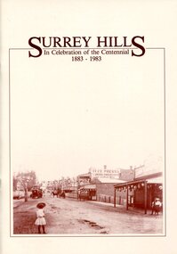
Book, Surrey Hills: in celebration of the centennial 1883-1983, 1983
A pictorial history of Surrey Hills based on information collected and based at the Surrey Hills Neighbourhood Centre. It includes early rural properties and diaries, the coming of the railway, land sub-division and early homes, schools, parks and recreation.A pictorial history of Surrey Hills based on information collected and based at the Surrey Hills Neighbourhood Centre. It includes early rural properties and diaries, the coming of the railway, land sub-division and early homes, schools, parks and recreation.surrey hills, railways, land use, migrants, spanish communities, transport, houses, wattle park, festivals and celebrations, churches, education, water supply, fire stations, hospitals, (mr) george klepper, ainger family, (mr) john woodhead, (mr) h. breedon, medical services, real estate agents, businesses, musical events and activities, entertainment, parks and reserves, scouts, guides -
 Surrey Hills Historical Society Collection
Book, Surrey Hills: in celebration of the centennial 1883-1983, Reprinted November 1992
A pictorial history of Surrey Hills and Mont Albert based on information collected by the history group at the Surrey Hills Neighbourhood Centre. It includes information about early rural properties and dairies, the coming of the railway, land sub-division and early homes, doctors, schools, churches, parks and recreation facilities.A pictorial history of Surrey Hills based on information collected and based at the Surrey Hills Neighbourhood Centre. It includes early rural properties and diaries, the coming of the railway, land sub-division and early homes, schools, parks and recreation.1992surrey hills, railways, land use, migrants, spanish communities, transport, houses, wattle park, festivals and celebrations, churches, education, water supply, fire stations, hospitals, (mr) george klepper, ainger family, (mr) john woodhead, (mr) h. breedon, medical services, real estate agents, businesses, musical events and activities, entertainment, parks and reserves, scouts, guides -
 Surrey Hills Historical Society Collection
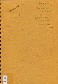
Book, An historical geography of Surrey Hills, 1882-1913, 1979
A thesis submitted for the Degree of Bachelor of Arts with Honours. This thesis presents in a description form, the development of Surrey Hills, an eastern suburb of Melbourne. The settlement and growth from a rural district in 1882 to a suburban centre in 1913.This thesis presents in a description form, the development of Surrey Hills, an eastern suburb of Melbourne. The settlement and growth from a rural district in 1882 to a suburban centre in 1913.surrey hills, geography, topography, j. knipe, land use, population -
 Surrey Hills Historical Society Collection
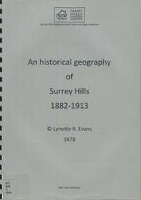
Book, An historical geography of Surrey Hills, 1882-1913, 1979
A thesis submitted for the Degree of Bachelor of Arts with Honours. This thesis presents in a description form, the development of Surrey Hills, an eastern suburb of Melbourne. The settlement and growth from a rural district in 1882 to a suburban centre in 1913.This thesis presents in a description form, the development of Surrey Hills. The settlement and growth from a rural district in 1882 to a suburban centre in 1913.surrey hills, geography, topography, j. knipe, land use, population -
 National Wool Museum
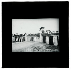
Photograph - Rural Property Entrance, J W Allen, 1900 - 1940
This item is part of a collection of seven black and white glass lantern slides previously housed together in a glass plate box. The slides are part of a greater collection of around forty three black and white glass lantern slides, along with other photographs and photo albums related to this collection. This item is associated with the New South Wales Graziers Association world tour of merino sheep 1928/9. The slides were possibly used as supporting material in presentations made by J W Allen when on tour.Black and white glass lantern slide with paper edging showing a fence and gate with a road in the foreground and trees in the background.agriculture, new south wales graziers association, travel, sheep, breeding, photography, glass lantern slides, j w allen -
 National Wool Museum
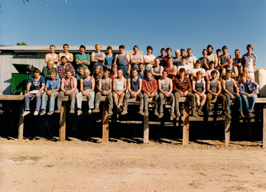
Photograph - Shearing Team at Puckapunyal Army Base, Seymour, 1987
Colour photograph showing an outdoor group portrait of people seated and standing on the deck of a shearing shed, with blue sky above and gravel road below. Handwritten text in black ink is shown on the back. back: [handwritten] Shearing Team Puckapunyal army Base Seymour / 75,000 Sheep, 21 Shearers plus shed staff Yard staff / and cooks / Started Shearing for Jim Walker / Sep 8th 1986shearing, agriculture, wool, workers, army base, seymour, victoria, rural life, people, portrait, working life, puckapunyal -
 Vision Australia
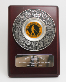
Photograph - Image, Sarawak Society for the Blind commemoration plaque, 1994
To share information and gain first hand knowledge, organisations sometimes undertook study visits to various countries. In appreciation for the hospitality and information gained as part of this, the Sarawak Society for the Blind - Sibu branch presented a commemorative plaque to RVIB. 1 plastic stand with engraved silver plate of a collage of images of rural village scenes, with yellow and black insignia for the Sarawak Society for the Blind Sibu branch rests in the middle.With compliments from Sarawak Society for the Blind (State) 1st August 1994royal victorian institute for the blind, sarawak society for the blind -
 Port Fairy Historical Society Museum and Archives
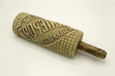
Tool - Butter Marker, 1920
Used to mark butter in the boxes from the Port Fairy Butter FactoryPossibly the only butter box marker left from the Port Fairy Butter FactoryTubular embossed "Bonnie Port Western district Choicest" wooden marker. Shaped like a rolling pin. One handleBonnie Port Western district Choicestlocal history, rural industry, butter making, port fairy butter factory -
 Port Fairy Historical Society Museum and Archives
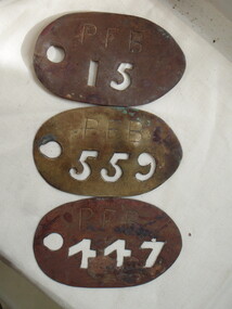
Functional object - cow tags, up to c.1960
A cow herdsman collected animals each morning and returned them each evening. They pastured on the common off Campbell St. Each cow had one of these numbers supplied by the Borough CouncilBrass tags for cows pastured on the common. No 15 heavier ring soldered around edge) 447 7 559. Numbers punched through brss platenos 15, 447, 559 PFBlocal history, rural industry, livestock, government local government council, cow, common -
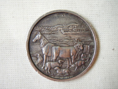 Port Fairy Historical Society Museum and Archives
Medal
Medal presented to J Goldie from local farm family at Port Fairy Agricultural Show, formerly named Villiers and Heytesbury Agricultural ShowRepresents medal awarded to entrants in Agricultural Shows c.1900Horse, cow, sheep, goat, pig, rooster in a rural sceneVilliers and Heytesbury Agricultural Association Awarded to J Goldie Jun. for Single Pony - not more than 14 hands 1900j goldie, agricultural, villiers and heytesbury, show -
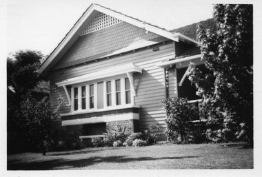 Surrey Hills Historical Society Collection
Digital photo, George L Coop, 688 Whitehorse Road, Mont Albert c 1953, c1953
This was the home of 3 generations of the Coop family: 1. Josephine and George Frank Coop (noted in Box Hill Rate Books for 1947-1954). 2. George Burton Coop (1906-1960) and his family. He was Assistant Chief Architect of Victoria in the Public Works Department (P.W.D.) George Burton Coop was born in c1906 in Williamstown, the son of Josephine Vistarini and George Frank Coop. He married Winifred Alice Trewartha in 1936 and they are listed in the electoral rolls at 688 Whitehorse Road in 1937. George died 3/4/1960, aged 54 years at Mont Albert. 3. George Burton and Alice Coop had 2 children: George Lister Coop - born St Georges Hospital, 8/10/1937 Alison - born c1945. The donor George Lister Coop informed that he initially attended Chatham State School because his first home was the Spanish Mission style flats at 346 Whitehorse Road, opposite Brenbeal Street, Balwyn. When his grandparents died, the family moved to 688 Whitehorse Road and he then attended Mont Albert Central School. The California bungalow style of housing was the dominant style of housing built in the interwar period through the northern parts of Surrey Hills and Mont Albert as formerly semi-rural land was subdivided for new housing. It was relatively inexpensive and affordable. In Australia the Californian bungalow drew upon elements that were popular across the United States from around 1910 to 1939. In Australia the style became popular from 1913. In Melbourne both timber and red brick were used as the main building material. Typically they are one or one and a half story houses and feature sloping roofs and eaves with unenclosed rafters and often a feature a dormer window (or an attic vent designed to look like one) over the main portion of the house. Decorative elements include wood shingles, part stucco rendered exteriors, brick, stone, rendered or a combination of these treatments to exterior chimneys and front porches supported by heavy timber, brick or stucco columns.A black & white photo taken at an angle of a Californian bungalow.californian bungalow, whitehorse road, george frank coop, (miss) josephine vistarini, (mrs) josephine coop, george burton coop, (miss) winifred trewartha, (mrs) winifred coop, george lister coop, alison coop -
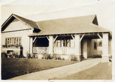 Surrey Hills Historical Society Collection
Digital photo, George L Coop, 688 Whitehorse Rd. Mont Albert c1950, c1950
This was the home of 3 generations of the Coop family: 1. Josephine and George Frank Coop (noted in Box Hill Rate Books for 1947-1954). 2. George Burton Coop (1906-1960) and his family. He was Assistant Chief Architect of Victoria in the Public Works Department (P.W.D.) George Burton Coop was born in c1906 in Williamstown, the son of Josephine Vistarini and George Frank Coop. He married Winifred Alice Trewartha in 1936 and they are listed in the electoral rolls at 688 Whitehorse Road in 1937. George died 3/4/1960, aged 54 years at Mont Albert. 3. George Burton and Alice Coop had 2 children: George Lister Coop - born St Georges Hospital, 8/10/1937 Alison - born c1945. The donor George Lister Coop informed that he initially attended Chatham State School because his first home was the Spanish Mission style flats at 346 Whitehorse Road, opposite Brenbeal Street, Balwyn. When his grandparents died, the family moved to 688 Whitehorse Road and he then attended Mont Albert Central School. The California bungalow style of housing was the dominant style of housing built in the interwar period through the northern parts of Surrey Hills and Mont Albert as formerly semi-rural land was subdivided for new housing. It was relatively inexpensive and affordable. In Australia the Californian bungalow drew upon elements that were popular across the United States from around 1910 to 1939. In Australia the style became popular from 1913. In Melbourne both timber and red brick were used as the main building material. Typically they are one or one and a half story houses and feature sloping roofs and eaves with unenclosed rafters and often a feature a dormer window (or an attic vent designed to look like one) over the main portion of the house. Decorative elements include wood shingles, part stucco rendered exteriors, brick, stone, rendered or a combination of these treatments to exterior chimneys and front porches supported by heavy timber, brick or stucco columns.A sepia photo taken at an angle from the street corner of the property. It is of a Californian bungalow with a driveway that extends through a carport, attached and roofed as part of the house, to the rear of the property. The veranda is accessed from under this covered area. The veranda and carport are supported by brick pillars and the veranda balustrades between are plain with an occasional wider feature panel. The front door is in shadow. There are rolled up striped canvas blinds on the veranda and at least 2 cane chairs. The main structure of the house is weatherboard with a terracotta tiled roof. There is a flower bed across the front of the house with an elevated brick flower box under the main window. There are no chimneys visible.californian bungalow, whitehorse road, george frank coop, (miss) josephine vistarini, (mrs) josephine coop, george burton coop, (miss) winifred trewartha, (mrs) winifred coop, george lister coop, alison coop -
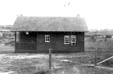 Surrey Hills Historical Society Collection
Photograph - Mrs Long's house, Delta Street area, Surrey Hills
The property is in the area that later became Delta Street, on the north side of Back Creek. Once roads were made and streets numbered, this became 1 Delta Road, Surrey Hills. Part of the undeveloped land would become part of South Surrey Park. According to Alan Holt's property register the house was built in c1920 and was demolished after having been neglected in 1991. He records it having had various names: 'Westward Ho', 'Pembroke' and 'The Oaks'. The first owner from 1920 was Eric Rowland Handyside Long who married Agnes May Hay Murray in March 1920. They had one son James Murray Long, born in September 1921. They divorced in 1937 and thereafter the property is listed in the name of Mrs Mary Hay Long, James M Long or Miss Mary Hay Long. According to Alan Holt, the house featured in the television series 'Carson's Law' in c1984.This is one of relatively few photos which record the transformation of rural land into the suburb that became Surrey Hills.A simple dark-stained timber house with a veranda and tiled roof. It is simply fenced with posts and wire mess. There are other houses in the background but part of the area remains as open space.delta road, back creek, south surrey park, wetward ho, pembroke, the oaks, hose names, miss agnes may hay murray, mrs agnes may hay long, mrs mary hay long, miss mary hay long, james murray long, carson's law -
 Surrey Hills Historical Society Collection
Photograph - Aerial view Riversdale Heights Estate area, c1923
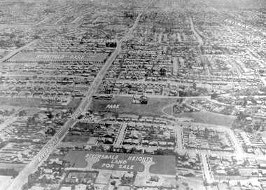
This was probably part of a real estate promotion for the sale of the Riversdale Heights Estate. This was subdivided by Messrs. Duncan and Weller. Of the allotments offered, 30 were sold and realised £4600. Date of this sale was c December 1923. This suggests that the date This are was one of the last pieces of former rural land to be sub-divided for housing in Surrey Hills.The land between it and South Surrey Park was sub-divided post WW1, hence the naming of the streets after sites of WW1 battles.A black and white reproduction of an aerial photo of the area near the corner of Warragul and Riversdale Roads looking west towards the city. Some features have been identified by name including the Riversdale Heights Estate, which was being sub-divided. North and South Courts are shown. Other roads (unmarked) in the foreground are Graham Street, Allie Street, Thistle Street, Lille Street, Amiens Street, and Marne Street. Beyond these is the area marked 'PARK' (South Surrey Park), which is devoid of vegetation. Areas of Camberwell and Canterbury are also shown. The area covered extends to beyond St Dominic's Church. The original is mounted on a cream deckle-edged paper.Beneath the original on the mount: "SOUTH SURREY HILLS LOOKING WEST c. 1936" [The reference to the sale in the Box Hill Reporter of December 1923 found on Trove suggests that this date is not accurate.] Rear top LH corner of original in Jocelyn Hall's handwriting: "For Centre / from Mr James Long"riversdale heights estate, riversdale road, allie street, south surrey park, lille street, thistle street, amiens street, marne street, south court, north court, duncan and weller, real estate sales, graham street, st dominics church, highfield park, canterbury primary school, aerial photo -
 Vision Australia
Audio (item) - Sound recording, Royal Victorian Institute for the Blind, Around the Institute: March 28, 2000
Around the Institute was a weekly program designed to keep clients and staff informed of events, activities and thoughts relating to low vision and blindness. It consisted of interviews undertaken by Jo Matthews, with sound engineer Ed Gamble, designed to inform, educate and explore on a variety of topics. March 28: Rural men losing sight – Jim Stewart and Leo Jones.royal victorian institute for the blind, radio shows -
Vision Australia
Audio (item) - Sound recording, Royal Victorian Institute for the Blind, Around the Institute: May 23, 2000
Around the Institute was a weekly program designed to keep clients and staff informed of events, activities and thoughts relating to low vision and blindness. It consisted of interviews undertaken by Jo Matthews, with sound engineer Ed Gamble, designed to inform, educate and explore on a variety of topics. May 23: NILS – Jane Evans, Rural Health week – Julie Johnson. royal victorian institute for the blind, radio shows -
Vision Australia
Audio (item) - Sound recording, Royal Victorian Institute for the Blind, Around the Institute: February 22, 2000
Around the Institute was a weekly program designed to keep clients and staff informed of events, activities and thoughts relating to low vision and blindness. It consisted of interviews undertaken by Jo Matthews, with sound engineer Ed Gamble, designed to inform, educate and explore on a variety of topics. February 22: Manager of Rural Services - Jane Bakos, Becoming a Paralympian - Russell Short.royal victorian institute for the blind, radio shows -
Vision Australia
Audio (item) - Sound recording, Royal Victorian Institute for the Blind, Around the Institute: March 20, 2001
Around the Institute was a weekly program designed to keep clients and staff informed of events, activities and thoughts relating to low vision and blindness. It consisted of interviews undertaken by Jo Matthews, with sound engineer Ed Gamble, designed to inform, educate and explore on a variety of topics. March 20: Job Track program – Karen McKenzie, Early childhood services in rural and remote areas – Rob Last. royal victorian institute for the blind, radio shows -
 Vision Australia
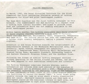
Document - Text, Talking Newspapers - 1st August 1986, 1/8/1986
In 1983 the Swan Hill Guardian became the first Talking Newspaper produced by the RVIB. In the three years since then 18 other rural newspapers followed and in 1986 there was a concerted push to add Melbourne papers to this network. This document provided an outline of the process of establishing a paper, and the role community groups and public libraries played in this.2 foolscap page document about the Talking Newspaper Serviceroyal victorian institute for the blind, talking newspaper service -
Vision Australia
Audio (item) - Sound recording, Royal Victorian Institute for the Blind, Around the Institute: October 14, 2003
Around the Institute was a weekly program consisting of interviews around a specific topic, undertaken by host Corey Nassau. October 14: For Sight week awards – Robyn McKenzie, Managing a rural property since losing sight – Neil Searle. royal victorian institute for the blind, radio shows -
Vision Australia
Audio (item) - Sound recording, Royal Victorian Institute for the Blind, Around the Institute: May 18, 2004
Around the Institute was a weekly program consisting of interviews around a specific topic, undertaken by host Corey Nassau. May 18: Rural Health campaign – Fiona Smythe, Willing and Able mentorship program – Robyn McKenzie. royal victorian institute for the blind, radio shows -
Vision Australia
Audio (item) - Sound recording, Royal Victorian Institute for the Blind, Around the Institute: May 17, 2005
Around the Institute was a weekly program consisting of interviews around a specific topic, undertaken by host Corey Nassau. May 19: An Eye on Rural Health program – Fiona Smythe, VisTech update – Jim Pipczak.royal victorian institute for the blind, radio shows -
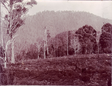 University of Melbourne, Burnley Campus Archives
Photograph - Sepia print, Rural View, Unknown
Sepia photograph. View with mountain and a road in the background. Possibly an excursion to Macedon or the Dandenongs. Photographs B91.409 to B91.417 appear to have come from the same photograph album.mountain, road, excursion, macedon, the dandenongs -
 City of Greater Bendigo - Civic Collection
Ceremonial object - Shire of Strathfieldsaye Chain with President medallion, unknown
Strathfieldsaye was first incorporated as a road district on 20 August 1861, and became a shire on 17 September 1866.Strathfieldsaye Council was suspended on 20 July 1993, with a commissioner appointed, after allegations of the council being divided and unworkable.On 7 April 1994, the Shire of Strathfieldsaye was abolished, and, along with the City of Bendigo, the Borough of Eaglehawk, the Rural City of Marong and the Shire of Huntly, was merged into the newly created City of Greater Bendigo. (source Wikipedia). Strathfieldsaye was divided into three wards, each of which elected three councillors; Axedale Ward, Mandurang Ward, Strathfieldsaye Ward. The Shire of Sthrathfieldsaye President's chain was manufactured by P. Blashki and Sons in Stirling silver with a 22ct gold plated finish. Consisting of 20 links, the centre piece depicts the Australian Coat of Arms and drop features an enameled Shire of Strathfieldsaye coat of arms. President / Shire of Strathfieldsaye / Victoria / 1866 / Dieu et mon droit / PROGRESS / 1866city of greater bendigo ceremonial item, shire of strathfieldsaye, president of strathfieldsaye shire -
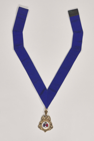 City of Greater Bendigo - Civic Collection
Ceremonial object - Rural City of Marong Medal, Blashki & Sons
The first local government authority for Marong was the Marong Road District (an early form of single-purpose local government), which was proclaimed on 19 August 1860. Its boundary was altered twice in 1862 and on 12 December 1864 it was re designated as a shire. It absorbed Raywood Borough in 1915, and was proclaimed a Rural City in 1990. On 2 December 1994, with the creation of Greater Bendigo City Council, it was abolished by being amalgamated with Bendigo City, Eaglehawk Borough, Huntly Shire, part of McIvor Shire, part of Metcalfe Shire and Strathfieldsaye Shire to form Greater Bendigo City.Rural City of Marong Stirling silver drop, plated in 22 ct gold with enamel centre piece. Medallion hangs from a royal blue neck ribbon. front; RURAL CITY OF MARONG / verso; FORMED AS / MARONG DISTRICT ROADS BOARD / 27th AUGUST 1861 / PROCLAIMED SHIRE OF MARONG / 23rd DECEMBER 1864 / PROCLAIMED RURAL CITY OF MARONG / 1st OCTOBER 1990shire of marong, city of greater bendigo ceremonial item -
 City of Greater Bendigo - Civic Collection
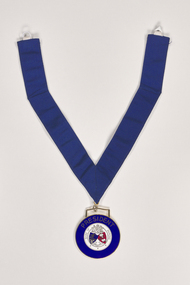
Ceremonial object - Shire of Marong President Medallion, P Blashki & Sons
The first local government authority for Marong was the Marong Road District (an early form of single-purpose local government), which was proclaimed on 19 August 1860. Its boundary was altered twice in 1862 and on 12 December 1864 it was re designated as a shire. It absorbed Raywood Borough in 1915, and was proclaimed a Rural City in 1990. On 2 December 1994, with the creation of Greater Bendigo City Council, it was abolished by being amalgamated with Bendigo City, Eaglehawk Borough, Huntly Shire, part of McIvor Shire, part of Metcalfe Shire and Strathfieldsaye Shire to form Greater Bendigo City.Manufactured by Blashki and Son this circular medal hangs from a royal blue gosgrain ribbon. The medallion has a gold edging with blue enamel outer band. Centre depicts Australia coat of arms and the Shire of Marong coat of arms.PRESIDENT / SHIRE OF MARONG / DIEU ET MON DROIT / INDUSTRIAshire of marong, marong presidents medal, city of greater bendigo ceremonial item -
 City of Greater Bendigo - Civic Collection
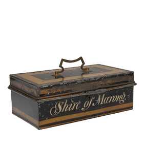
Functional object, Shire of Marong, Unknown
The first local government authority for Marong was the Marong Road District (an early form of single-purpose local government), which was proclaimed on 19 August 1860. Its boundary was altered twice in 1862 and on 12 December 1864 it was re designated as a shire. It absorbed Raywood Borough in 1915, and was proclaimed a Rural City in 1990. On 2 December 1994, with the creation of Greater Bendigo City Council, it was abolished by being amalgamated with Bendigo City, Eaglehawk Borough, Huntly Shire, part of McIvor Shire, part of Metcalfe Shire and Strathfieldsaye Shire to form Greater Bendigo City.Painted metal tin with handle on top. Currently locked closed.Shire of Marongshire of marong -
 City of Greater Bendigo - Civic Collection
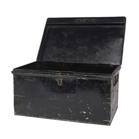
Functional object - Metal Box, Unknown
The first local government authority for Marong was the Marong Road District (an early form of single-purpose local government), which was proclaimed on 19 August 1860. Its boundary was altered twice in 1862 and on 12 December 1864 it was re designated as a Shire. It absorbed Raywood Borough in 1915, and was proclaimed a Rural City in 1990. On 2 December 1994, with the creation of Greater Bendigo City Council, it was abolished by being amalgamated with Bendigo City, Eaglehawk Borough, Huntly Shire, part of McIvor Shire, part of Metcalfe Shire and Strathfieldsaye Shire to form the City of Greater Bendigo. This metal box contained a roll of admission tickets and was possibly used for holding cash at the swimming pool or other municipal facility. Lockable painted metal box. Shire of Marongshire of marong -
 City of Greater Bendigo - Civic Collection
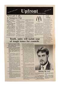
Newspaper, Shire of Marong, Upfront, c 1989
Marong was first incorporated as a road district on 27 August 1861, and became a shire on 23 December 1864. On 1 October 1915, the Borough of Raywood, which was gazetted on 17 January 1865 on 23.31 square kilometres of land 28 kilometres north of Bendigo was united with Marong. On 1 October 1990, the Shire of Marong became a rural city, under the Local Government Act 1989. In a report on 17 February 1994, the Local Government Board recommended that the five councils in the Bendigo region merge to form a "super city", with a population of about 81,000. Marong, Eaglehawk and Huntly had earlier objected to the proposal, and the Board noted a weak no vote against the merger proposal in a referendum in the region; about 70% had voted against, but with a turnout of between 30% and 40% of eligible voters. The three councils filed a writ in the Supreme Court, alleging failure to follow process by the Minister for Local Government, Roger Hallam, but by the time the new "super city" was announced, the writ had not yet been heard, and on 24 March 1994, the Rural City of Marong successfully applied for an injunction blocking the publication of the gazette the following day abolishing the five councils and appointing three commissioners. The government responded by introducing legislation, the City of Greater Bendigo Bill 1994, to Parliament, to effectively override the Supreme Court action, with Hallam saying "the bill would make clear that the Government is determined to achieve its objective for a more efficient municipal structure for the Bendigo region." Marong mayor Robert Hynes described the action as "terribly disappointing", adding, "One way or another, I believe it does mean an end to our fight... it seems the Government are above the law to me." On 6 April 1994, Marong voted to drop the Supreme Court action, effectively in doing so voting itself out of existence, and on 7 April 1994, the Rural City of Marong was abolished, and along with the City of Bendigo, the Borough of Eaglehawk and the Shires of Huntly and Strathfieldsaye, was merged into the newly created City of Greater Bendigo. On 29 April 1994, the Minister confirmed the Bill was not being proceeded with. https://en.wikipedia.org/wiki/Rural_City_of_MarongEight page newspaper style council newsletter providing community updates, news and information. shire of marong, city of greater bendigo amalgamation, councillor phillip eddy, rural city of marong -
 City of Greater Bendigo - Civic Collection
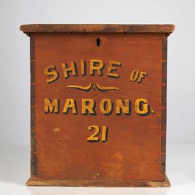
Functional object - Ballot Box, Shire of Marong, Shire of Marong 21, Unknown
The first local government authority for Marong was the Marong Road District (an early form of single-purpose local government), which was proclaimed on 19 August 1860. Its boundary was altered twice in 1862 and on 12 December 1864 it was re designated as a Shire. It absorbed Raywood Borough in 1915, and was proclaimed a Rural City in 1990. On 2 December 1994, with the creation of Greater Bendigo City Council, it was abolished through the amalgamation which took place between Bendigo City, Eaglehawk Borough, Huntly Shire, part of McIvor Shire, part of Metcalfe Shire and Strathfieldsaye Shire to form the City of Greater Bendigo. This box would have been used to collect votes during council elections.Wooden, painted, lidded box with hinged opening lid. Central slit in lid to insert ballot papers. Front face painted in black and gold paint. Hinged at back of box with lock on front. Front of box Shire of / Marong / 21shire of marong