Showing 16993 items
matching snowy-river-bridge-1976
-
 Orbost & District Historical Society
black and white photograph, 1884?
James Alexander Robertson was born 14th June, 1855, at Pentridge. the Coburg area which was known as Pentridge at the time, and prior to the building of the gaol. His parents were James Thomson Robertson and Esther (nee Hale), At age 20 James became the first selector on the Snowy River at Lochend. He took up Lots 1, 2 and 3, in the Parish of Newmerella in 1875; with his selection being ratified on May 1st, 1876. The selection included hill and river flat land in the area near where Icy Creek enters the Snowy River. James gradually improved and farmed the property; he cleared and drained Icy Creek and constructed the first known flood-gate on the Snowy River. To meet his farming commitments he supplemented his income by working on the construction and maintenance of roads and drains in the Newmerella area. He gained a contract with the Bairnsdale Shire council to construct the first road cutting down Burn’s Hill at Newmerella. His tender was for £16 ($32), and it took him, with four others, two months to complete the contract. He was single, and, after his untimely death at aged 29, in 1884, his parents and surviving unmarried sisters and brothers moved from Sarsfield to take over his selection at Lochend. (more information Newsletter April 2013)James Robertson was the first selector of land at Lochend, Orbost.A small black / white portrait photograph, oval shaped with a white background. It is of a middle-aged man with a full beard and moustache.on front at bottom - typed in black -:"James Alexander Robertson, Late of Lochend, Snowy River"robertson-james-alexander lochend-robertson -
 Kew Historical Society Inc
Photograph, Burke Road Bridge, 1930s
Without bridges, Kew remained cut off from the City of Melbourne, only being accessible by Punt. Private and public bridges were constructed from the 1850s, beginning with the Hawthorn Bridge linking Bridge and Burwood Roads. A bridge across the Yarra at Burke Road was created as early as 1873. Since that first wooden bridge, a number of later bridges, typically on concrete pylons have been built, in 1926 and again during the 1970s.Sepia, faded photograph of the Burke Road Bridge linking East Kew and Ivanhoe. The previous bridge, constructed in 1926 was submerged beneath the flood waters in the 1934 mega-flood of the Yarra.burke road bridge (kew), bridges -- river yarra -
 Marysville & District Historical Society
Photograph (Item) - Black and white photograph, Fred Kruger, Scene on the Watts River near Fernshaw, Unknown
A copy of a black and white photograph on the Watts River near Fernshaw in Victoria.A copy of a black and white photograph on the Watts River near Fernshaw in Victoria taken by Fred Kruger. Fred Kruger (born Johan Friedrich Carl Kruger, 18 April 1831 – 15 February 1888) was a German-born photographer noted for his early photography of landscape and indigenous peoples in Victoria, Australia. Fernshaw was a rural township 63 km northeast of Melbourne and 10 km northeast of Healesville. Situated on the Watts River, near where a log had fallen making a convenient crossing, Fernshaw was settled in the 1860s. It provided good country for orchards and berry growing. The location was at the foot of Blacks Spur, with Mounts Juliet and Mondah rising on either side, providing spectacular scenery. There were nearby fern gullies giving rise to the name – ‘shaw’ is old English for thicket or wood. By 1875 Fernshaw had a post office (1865), two hotels, a school (1871), and stores. It was famed for its beauty, attracting tourists. In 1886 the Melbourne and Metropolitan Board of Works began work on the Watts River water catchment scheme – later to become Maroondah – and the Board obtained approval for the catchment country to be reserved and kept free of settlement. This required the removal of the Fernshaw township, which was completed by about 1890.fernshaw, watts river, victoria, fred kruger, photograph -
 Yarra Glen & District Historical Society
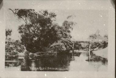
Sepia postcards, Yarra Glen bridge
Photograph of wooden bridge over the Yarra River taken from a point just north of the river crossing at Yarra Glen early 20th century. The town of Yarra Glen is to the right (out of frame). A post and rail fence indicates the road to Yering and Lilydale to the east of the bridge. A bend of the river is in the foreground and trees line the eastern bank.On back of postcard at the top "POST CARD". On the left hand side "THIS SPACE MAY BE USED FOR PRINTED OR WRITTEN MATTER". On the right hand side "ONLY THE ADDRESS TO BE WRITTEN HERE". In a box in the right hand corner "A HALF-PENNY STAMP TO BE PLACED HERE". Along the left hand margin "Ajax series. Printed in England" yarra river, post and rail fence, wooden bridge, river crossing, river bridge, yarra glen bridge, yering -
 Phillip Island and District Historical Society Inc.
Photograph, Phillip Island Bridge, 1968/9
Construction of 2nd 1969 Bridge which was opened November 1969. From the Jack Jenner CollectionNew Bridge almost completed. San Remo in background with rising hill. Tractor on Bridge.local history, photographs, civil engineering, bridges, phillip island bridges, black & white photograph, jack jenner collection, public construction -
 Lakes Entrance Historical Society
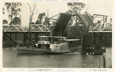
Postcard - P.S. Tanjil, Vogt, Stanley, 1920 c
Two copies existBlack and white postcard showing P S Tanjil passing downstream under Swan Reach Bridge on Tambo River, East Gippsland, Victoria.Paddle Steamer Tanjil Tambo River Swan Reach Bridge. S. Vogt Bairnsdaleships and shipping, waterways, bridges -
 Stawell Historical Society Inc
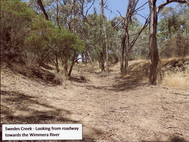
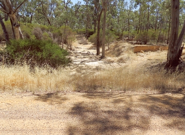
Photograph, Swedes Creek Looking looking towards the Wimmera River 2017 -- Coloured
Colour Photo of Swedes Creek looking from roadway towards the Wimmera River 2017. (Jan)Colour photograph of a dry creek bed. Trees along and around the dry creek.Swedes Creek - Looking from roadway towards the Wimmera River.water -
 Phillip Island and District Historical Society Inc.
Photograph, Phillip Island Bridge Opening, 1969
Opening of 2nd Bridge. Speaker President Shire of Bass. This Bridge replaced the Suspension Bridge. From the Jack Jenner Collection.Opening of second Bridge 1969. Speaker, President, Shire of Basslocal history, photographs, civil engineering, bridges, opening of phillip island bridge, black & white photograph, jack jenner collection, phillip island bridges, public construction -
 Melbourne Legacy
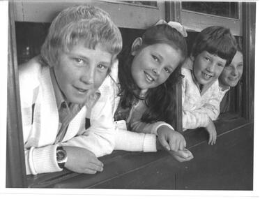
Photograph - Junior legatee outing, Camp 1976, 01/1976
A photo of 4 children leaning out from a train carriage windows. They were junior legatees travelling by train to attend a Legacy Camp. It came from an envelope with other camp photos. A newspaper article in the Herald on 10 January 1976 says the children were: Robert Bennett, his sister Anastasia Bennett and brother Patrick Bennett and a friend Debra Packwood as they arrived in Spencer Street Station enroute to Camperdown for a two week holiday organised by Legacy. The Legacy envelope was marked "P6 Junior Legatee Camps and Hols" in red pen, and dated Jan 1977 in pencil. The contents will be items 00418 to 00425. Melbourne Legacy provided camps for junior legatees - the children of deceased servicemen. The camps gave the children an opportunity of a summer holiday with other Legacy children.A record of Junior Legatee camps.Black and white photo of children looking out a train window on their way to Somers Camp.Handwritten on back "Jan 1976 on train (Hols)" in blue pen. Stamped "The Property of Melbourne Legacy" in purple ink. Stamped "Copyright The Herald and Weekly Times" in blue ink. junior legatee outing, trains, camp -
 Lakes Entrance Historical Society
Photograph - Gippsland Heritage Journal No 25 2004 copy in Police dropfile, 1940
three police officers at CRB Camp Martins Creek while searching for Snowy River Bandit Martins Creek Victoria - Story by R Haldane in Gippsland Heritage Journal No 25 2004 copy in Police dropfileBlack and white photograph of three police officers at CRB Camp Martins Creek while searching for Snowy River Bandit Martins Creek Victoriapolice, law and order -
 Melbourne Tram Museum
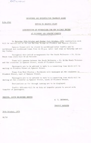
Document - Notice, Melbourne & Metropolitan Tramways Board (MMTB), "Construction of Foundations for new railway bridge at Flinders and Spencer St", 26/10/1976 12:00:00 AM
Notice - printed on foolscap paper, MMTB Notice to Traffic Staff, D 2566, issued by R. C. Drummond Traffic Manager, 26/10/1971 of the "Construction of Foundations for new railway bridge at Flinders and Spencer St" about the closure of Spencer St and alternative arrangements for tram passengers - walk - Saturday 30/10/1976 and Sunday 31/10/1976.has in ink in the top left hand corner "60 crew"trams, tramways, railways, vr, spencer st, bridges, murla -
 Falls Creek Historical Society
Photograph - Dick Stericker & Hans Fisher building bridge 1961
This item is from the private collection of George Shirling of Red Onion, Falls Creek. It depicts Dick Stericker & Hans Fisher constructing a wooden bridge. They both arrived in Falls Creek in the early 1960s. Hans worked on the slopes in summer and in winter, including building access bridges over the race-line as shown in this photograph. In 1965 Hans started as the chef Koki Alpine Lodge owned by George Shirling. He later worked as cook at various Falls Creek eating houses, as well as working for the lift company and slope maintenance People like Hans made Falls Creek. He passed away at Noosa, Queensland on 18th January 2022. George Shirling arrived in Falls Creek in 1962. He engaged Phil Nowell to build the original Koki Alpine Lodge which opened in 1965 with 14 beds. George operated the lodge with Michael “Baldy” Blackwell as manager. He also graduated in sport psychology in 1981 and was invited to become team psychologist for the Australian Winter Olympic team which went to Albertville, France, in 1992. He later owned the Red Onion Chalet. George credited the success of Koki to “Baldy” Blackwell. “Baldy” and Phil Nowell started the Trackers Mountain Lodge in partnership during the 1980s. In 1971 George sold Koki Lodge to Sigi Doerr. In 2024 the renamed Koki Alpine resort remains a highly popular destination in Falls Creek. George Shirling passed away on 27th February 2023. He had remained actively involved in Falls Creek and was generous with his time and knowledge, always an amazing supporter of The Falls Creek Museum and Falls Creek Village.This item is significant because it features two prominent members of the Falls Creek community.A black and white photograph of Dick Stericker & Hans Fisher taking a break whilst building a bridge. A typed George Shirling Collection number and description is attached. On label: ITEM NO. 148 Dick Stericker & Hans Fisher - smoko - while building bridge over raceline - Village T-bar, 1961george shirling, red onion, hans fisher -
 Orbost & District Historical Society
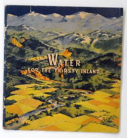
book, Water For the Thirsty Inland, 1945
Water For the Thirsty Inland was published by The Murrumbidgee Valley Water Users Association as a case for diversion of part of the Snowy River waters to the Murrumbidgee. In 1950 The Murrumbidgee Valley Water Users Association and the League established the Murray-Murrumbidgee Development Committee to ensure the Snowy Scheme was completed.This book is a significant research tool for the history of the diversion of the Snowy River.A 44 pp book, titled Water For The Thirsty Inland. On the front cover is a coloured print of a painting of a river (Snowy River?) from the mountains to the flats. The text of the title is white with a black shadow. The book contains b/w photographs and the print is black and green.Some pencilled notes on back.snowy-river murrumbidgee-valley-water-users' irrigation -
 Phillip Island and District Historical Society Inc.
Photograph, Phillip Island Bridge, 1968/9
Construction of 2nd 1968/69 Bridge connecting San Remo with Newhaven. From the Jack Jenner CollectionPhotograph showing two Bridges. Old Suspension Bridge on left. 1969 Bridge with all pillars in and decking completed only in foreground - taken from San Remolocal history, photographs, civil engineering, bridges, phillip island bridges, black & white photograph, jack jenner collection, public construction -
 Orbost & District Historical Society
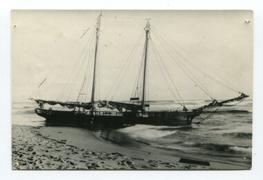
black and white photograph
The “Glengarry” beached at Marlo The schooner Glengarry was a well-known trader on the Gippsland coast and had been stranded on a number of previous occasions including at the Natural Entrance joining the Gippsland Lakes to Bass Strait – Ninety Mile Beach, Lakes Entrance, c 1877 . In May 1898, the vessel struck a submerged object while crossing the Snowy River bar at Marlo and was beached, eventually becoming a total loss. Until t he railway came to East Gippsland goods were shipped from Marlo to Melbourne. This is a pictorial record of a well-known trading ship involved in that river transport.Three copies of a black / white photograph of the Schooner Glengarry wrecked in 1891 at the Snowy River entrance at Marlo.schooner-glengarry shipping transport-orbost -
 Linton and District Historical Society Inc
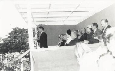
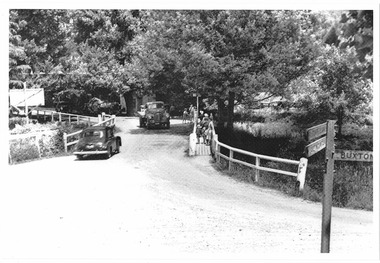
Photograph, Bridge Opening
Part of photograph album donated by Mrs Faull. The picture shows the opening of the Glenelg Highway Bridge over the Woady Yaloak Creek between Linton and Scarsdale.Black and white photograph of bridge opening. Bridge in background with people and cars.events, bridge openings, faull collection, woady yaloak creek -
 Stawell Historical Society Inc
Photograph, Dunmunkle Creek looking towards Wimmera River 2017 -- Coloured
Colour Photo of Dunmunkle Creek looking towards Wimmera River 2017.Colour photograph of dry creek bed surrounded by vegetation. Dunmunkle Cree looking towards Wimmera River from roadway - 2017.water -
 Marysville & District Historical Society
Photograph (Item) - Black and white photograph, Unknown
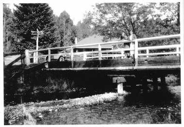
A copy of a black and white photograph of the bridge over the Steavenson River.A copy of a black and white photograph of the bridge over the Steavenson River. The Steavenson River is named after the Victorian Assistant Commissioner of Roads and Bridges, John Steavenson who arrived in Victoria in the early 1860s.marysville, victoria, steavenson river, photograph, john steavenson -
 Marysville & District Historical Society
Photograph (Item) - Black and white photograph, Unknown
A copy of a black and white photograph of the bridge over the Steavenson River.A copy of a black and white photograph of the bridge over the Steavenson River. The Steavenson River is named after the Victorian Assistant Commissioner of Roads and Bridges, John Steavenson who arrived in Victoria in the early 1860s.marysville, victoria, steavenson river, photograph, john steavenson -
 Wodonga & District Historical Society Inc
Photograph - Bethanga Bridge
The Bethanga Bridge was built between 1927 and 1930 as a joint venture between Victoria and New South Wales and was a key element of the River Murray Waters Agreement. It consists of nine spans of 82 metres long. Each span is supported between double reinforced concrete pylons and a riveted steel camel back Pratt truss. The overall span of the bridge is a length of 752 metres. It was completed in 1929 at a cost of £194,000. The road deck was initially constructed from timber but was replaced in 1961 with a concrete waffle slab deck 7.7metres wide. In 1961 the bridge deck and truss structure were raised 300 millimetres to allow for the enlargement of the lake. The bridge was designed in NSW by road engineer Percy Alan and the trusses were built by the Charles Ruwolt Pty. Ltd. Charles Ruwolt Pty. Ltd. was originally established by Charles Ruwolt as a foundry at Wangaratta in 1902 and transferred its operations to Richmond, Melbourne in 1914. By 1938 it had become one of the biggest engineering companies in Australia. After Charles Ruwolt’s death in 1946, Vickers Ltd. acquired the company and in 1948 the firm became known as Vickers Ruwolt Pty. Ltd. Because of the Bethanga Bridge’s unique location, over the waters of a dam with the border running down the centre of the body of water, the Bethanga Bridge is the only built structure shared by both Victoria and New South Wales. As the border of New South Wales aligns with the southern bank of the Murray River all of the other bridges along its length are deemed to be in New South Wales. The Bethanga Bridge is listed on both the New South Wales State Heritage Register and the Victorian Heritage Database. In 2015 the Bethanga Bridge was nominated for a heritage award by the Institution of Engineering Australia.These images are significant because they document the construction of a bridge which links Victoria and New South Wales and has been recognised for its historical, technical and engineering significance.A collection of photos documenting the construction of the Bethanga Bridge which links the States of Victoria and New South Wales as part of the construction of the Hume Dam .bethanga bridge, hume dam constuction, charles ruwolt, percy allan engineer -
 Robin Boyd Foundation
Document - Script, Robin Boyd, The Flying Dogtor and The Snowy Mountain's Secret. Adventure No. 6, The Lake Monsters, Episodes 44-52, 1963
This transcript outlines the storyline of the final adventure (no. 6) of The Flying Dogtor (The Lake Monster) in 4 chapters, episodes 44-52. The Dogtor is called to the Snowy Mountains Scheme to solve the mystery of a sea-serpent in Lake Eucumbene. After investigations around and under the water, he solves the mystery and is finally awarded suitably in Canberra.The Flying Dogtor" series was broadcast on Australian Television Network (later becoming the Seven Network) between February and April 1964 (see item D254 for schedule).Typewritten, quarto, carbon copy, 14 pagesOn top left 'Robin Boyd script for Flying Dogtor 14 pages' in Penleigh Boyd's handwriting.the flying dogtor, snowy mountains, robin boyd, crawford productions, manuscript -
 Queenscliffe Maritime Museum
Pamphlet - Clyde River Scotland, Pamphlets, brochures and news article re travelling on the Clyde River Scotland
Clyde River boats ScotlandClyde River boatsColourt & B&W brochures, pamphlets & news article re boats on the Clyde River Scotland.Reverse " NIL "historical references -
 Sunbury Family History and Heritage Society Inc.
Photograph, Catanery Bridge, Bulla, c1980s
The narrow swing catanery bridge was built behind the school across the Deep Creek downstream from the bluestone Bulla Bridge. It was built so that children who lived on the south side of Bulla Township could access the school more easily and in shorter time than if they had to go by the main roads.The bridge was constructed in the days when most children walked to school. The use of this bridge cut the children's travel time and distance to school quite considerably and was used for many years until the school was closed in 1996.A coloured photograph of the children on a narrow swing bridge and the path they used to approach the bridge over open ground. bulla primary school, swing bridge, bridges, catanery bridge -
 Wodonga & District Historical Society Inc
Album - Ringer's River by Des Martin - Plate 33 - Escaping the Police
The bodies of mother and son are driven side by side to burial while the shops shut down and all Overton turns out for the funeral. Ellen's elder son Con O'Hara, and Sean O'Day ride as outriders to the hearses. Sgt. Baker and his men arrive at the church, the Sgt. approaches Con, declares that no police action will be taken before the town re-opens, and asks if he can provide an escort for the cortege. The funeral over O'Day tarries till after the shops have opened and Sgt. Baker sets a trap for him on the bridge over the Murray. Cornering him on the bridge he says it will give him great pleasure to personally escort him all the way to the police station. "All the way Sergeant?" asks O'Day. "Then come on!" With which he jumps his horse over the rail of the bridge. D.J. Martin on Pampas Air.The album and images are significant because they document literature written by a prominent member of the Wodonga community. The presentation of this precis was supported by several significant district families and individuals.Ringer's River Album Coloured photo Plate 33des martin, many a mile, ringer's river, northeast victoria stories -
 Eltham District Historical Society Inc
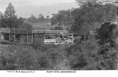
Photograph, The Rose Stereograph Company, Plenty River, Greensborough, c.1939
View looking northwest along the Plenty River towards the original bluestone Greensborough Bridge (since demolished). A timber pedestrian footbridge added after construction is visible with two people crossing. In the distance is a wide flat verge, now present day Carter Reserve and on the far side seven men digging and a set of terraced steps dug out in the earth bank. Present day Pioneer Reserve is to the right of the river in foreground. This glass plate negative was used to manufacture postcards (1:1 printing) for commercial sale by the Rose Sterograph Company and its subsidiaries. George Rose founded the Rose Stereograph Company in 1880 and was joined by Herbert (Bert) Cutts in the early 20th Century. The pair formed a lifetime working partnership and strong personal friendship. Assisted by George’s two sons, Herbert George and Walter, and later by Neil Cutts, the Rose Stereograph Company continued its operations for more than 140 years. The company was initially built on stereographs, but as cinema took over and stereographs fell out of fashion, the Rose Stereograph Company developed Australia’s first commercially viable photographic postcard business. Specialising in postcards of iconic historical moments and significant landmarks, The Rose Stereograph Company became a staple of the Australian travel industry.This remarkable collection of glass plate negatives, transparencies, and postcards – arguably Australia’s most significant photography collection outside of public hands – has been passed down through the generations, surviving war, relocation, and the harsh Victorian climate. The historic Rose Stereograph collection is the culmination of George Rose’s dream of capturing and preserving precious moments in time and remains the legacy of the Rose and Cutts families. It is with great sadness that the Cutts family says goodbye to a collection that spans five generations and 140 years. The Cutts family understands that for these historically important pieces to rest with one family is to deny others the pleasure of their custodianship.Glass Plate Negative Size: 9 x 14 cmPlenty River, Greensborough, Published by W. M. Butterworh No. 2postcard, travel, rose stereograph company, glass plate negative, greensborough, carter reserve, footbridge, greensborough bridge, main road, plenty river, w. m. butterworth, pioneer reserve, construction, peter and elizabeth pidgeon collection -
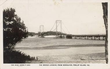 Phillip Island and District Historical Society Inc.
Photograph - Post Card, Suspension Bridge, 1940's
One of a collection of 18 photographs & postcards donated by Jill Yeoman. The Suspension Bridige was built during 1940. Postcard to Mrs Hughes & Lilly from Rita telling of a nice holiday visiting various towns and enjoying New Year's Eve fireworks on the Cowes beach.Black & White postcard of the Suspension Bridge from Newhaven, Phillip Island, to San Remo The Rose Series P. 2023. The bridge looking from Newhaven, Phillip Island, Vic.suspension bridge phillip island, phillip island bridge, jill yeoman -
 Ringwood and District Historical Society
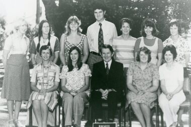
Photograph, Ringwood State School - Teachers, 1976
Black and white photograph - Teachers, 1976"Attached to photograph" Back Row- L to R: Elizabeth Burgess, Jill Earney, Diane Chitty, Len Hatfield, Doreen Turner, Elizabeth McCallum, Aneli Symons. Front Row- L to R: Isabel Marshall, Adrienne Dyall, Baden Chadwick, Anne Webber, Marj Smith. -
 Stawell Historical Society Inc
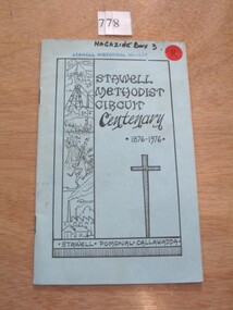
Book, Allan Howell et al, Stawell Methodist Circuit Centenary 1876-1976 for Stawell, Pomonal & Callawadda, 1976
Booklets written for the Centenary Celebrations at Stawell Methodist ChurchLight blue card with black line border and drawing along left side the title in black with a cross below. Stawell methodist ircuit Centenary 1876 -1976. Stawell. Pomonal Callawadda.stawell religion -
 Eltham District Historical Society Inc
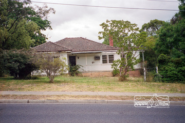
Photograph, Margaret Ball, 74 Bridge Street, Eltham, Nov-Dec 1999 now part of units 72-74 Bridge Street, 1999
The Margaret Ball (Pre 1960s Houses) Collection was a personal project initiated to mark the year 2000 and arose as a result of the disappearance of many pre-1960s parts of Eltham due to development. Approximately 200 pre-1960s style houses that were left in Eltham between Main Road and east to Bible Street, between Cecil Street to the north and south to Dalton Street were photographed in late 1999. Not all of the houses could be photographed; some because the garden or trees blocked the view of the house, others because of rubbish or cars were in the way, some because people were working on the house or in the gardens at the time.Roll of 35mm colour negative film, 7 stripsKodak GC 400-6eltham, houses, streets, margaret ball (pre 1960s houses) collection, bridge street -
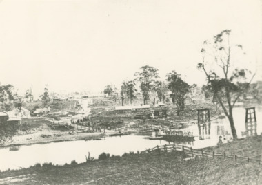 Lakes Entrance Historical Society
Photograph - Mitchell River Bairnsdale Victoria, F Cornell, 1870
Black and white photograph of the punt on the Mitchell River and the first bridge under construction. In distance can be seen the growing township of Bairnsdale Victoriaboats and boating, businesses, rivers