Showing 1875 items matching "subdivision"
-
 Whitehorse Historical Society Inc.
Article, Historic hostel bulldozed for development, 1994
Historical Leawarra Hostel on the former Winlaton site has been bulldozed for proposed residential subdivision in two lots.Historical Leawarra Hostel on the former Winlaton site has been bulldozed for proposed residential subdivision in two lots. The building was once the home of Joseph Tweedle[Tweddle] who financed the Tweedle Hospital in Footscray.Historical Leawarra Hostel on the former Winlaton site has been bulldozed for proposed residential subdivision in two lots. winlaton, leawarra hostel, tweddle, joseph -
 Kew Historical Society Inc
Photograph - Cosy Five Roomed Rough Cast Bungalow, Kew, J E Barnes, c.1920
Subdivision plans are historically important documents used as evidence of the growth of suburbs in Australia. They frequently provide information about when the land was sold on which a built structure was subsequently constructed as well as evidence relating to surveyors and real estate and financial agents. The numerous subdivision plans in the Kew Historical Society's collection represent working documents, ranging from the initial sketches made in planning a subdivision to printed plans on which auctioneers or agents listed the prices for which individual lots were sold. In a number of cases, the reverse of a subdivision plan in the collection includes a photograph of a house that was also for sale by the agent. These photographs provide significant heritage information relating house design and decoration, fencing and household gardens. The photograph is also aesthetically significant as it was taken by J. E. Barnes, a nationally significant photographer. He was the most important photographer to have worked in Kew. He was active as a photographer in the district from c.1906 until his death in 1921. Best known as 'the Embarkation Photographer' (see the Australian War Memorial collection), Josiah Earl Barnes was also the official photographer employed by the Borough (and later Town, then City) of Kew. He clearly also completed commercial jobs for local businesses, as is the case in this photograph of a house for a local real estate and financial agent. A modest weatherboard house with rough-cast rendered walls. The gabled entrance incorporates elements of the Japanese aesthetic. The strong lines of the dark timber gable are reinforced by the colour and shape of the pickets in the fence. In contrast to an earlier period, the chimneys appear truncated. The use of extensive double-hung sash windows in the front rooms reflects a new interest in light in houses. The use of separate sunshades over windows in an earlier period is here replaced by an extension of the roofline over the window. The photographer Josiah Barnes died in 1921; so, the photograph of the house must predate this date. The location of the house, which was advertised for sale, has to date not been identified. Illegible inscription. Photographer's information on mount.josiah earl barnes, j e barnes, photography - kew, interwar housing - victoria, 1920s housing - kew -
 Kew Historical Society Inc
Photograph - 2 Young Street, Kew, Paramount Photos, 1920s
Subdivision plans are historically important documents used as evidence of the growth of suburbs in Australia. They frequently provide information about when the land was sold on which a built structure was subsequently constructed as well as evidence relating to surveyors and real estate and financial agents. The numerous subdivision plans in the Kew Historical Society's collection represent working documents, ranging from the initial sketches made in planning a subdivision to printed plans on which auctioneers or agents listed the prices for which individual lots were sold. In a number of cases, the reverse of a subdivision plan in the collection includes a photograph of a house that was also for sale by the agent. These photographs provide significant heritage information relating house design and decoration, fencing and household gardens.A prepossessing, large home constructed in the Arts and Crafts style. Located on the banks of the Yarra at 2 Young Street, Kew overlooking the factories of Richmond, the design of the house takes account of the gradient with the addition of a level below the front entrance. The elegant roof includes a number of projecting gables and dormers. The gables are typically half-timbered and rendered. In addition to the asymmetrically placed portico, there are at least two open verandas, supported by timber pillars and with roofs that reflect the overall pitch of the roof of the housereal estate photographs, 2 young street - kew -
Port Melbourne Historical & Preservation Society
Plan - Sandridge, Department of Lands and Survey, "The Township of Sandridge", 5 Nov 1860
Map of Sandridge, lithographed 1860, showing subdivisions on Evans Street, but no other development West of the railway Lihographed at the Department of lands and Survey, Melbourne 5th November 1860. Hand drawn annotations added at unknown date.Hand written "clay ground" 18 chains long, 7.5 chains broad, 26 chains from railwayengineering - roads streets lanes and footpaths, sandridge lagoon, transport - railways, town planning, local government - borough of sandridge -
 Whitehorse Historical Society Inc.
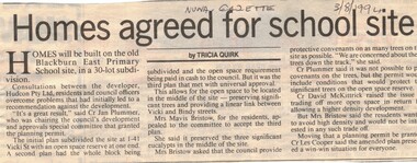
Article, Homes agreed for school site, 3/08/1994 12:00:00 AM
Subdivision of former Blackburn East Primary School Site,Article on development of 30 lot subdivision of former Blackburn East Primary School Site, Blackburn South. 1 - 41 Vicki Street. Developer Audcon Pty Ltd. In Nunawading Gazette 3 August 1994.Subdivision of former Blackburn East Primary School Site,blackburn east primary school, no. 4800, vicki street, blackburn south, bindy street, hudcon pty ltd, land subdivision -
 City of Kingston
Pamphlet - Colour, T. H. Ould Publishing Co, The Ridge Estate, Cheltenham, c. 1930
Sales plan for land in the suburb of Cheltenham, bounded by Johnston Street, Silver Street and Cavanagh Street, incorporating lots on either side of Sunray Avenue.The developing urban area of Cheltenham within the City of Kingston. This land sale pamphlet illustrates the subdivision of land within the municipality and the changing demographic of the district as new houses are constructed close to infrastructure.Colour pamphlet advertising for sale lots in The Ridge Entrance Estate, Cheltenham. Incorporates a map of the estate bordered by Johnston Street, Silver Street and Cavanagh Street, including subdivision lots on either side of Sunray Avenueland sales, estate, cheltenham -
 Whitehorse Historical Society Inc.
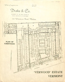
Document, Verwood Estate, Vermont
A subdivision plan of 'Verwood Estate', Vermontnon-fictionA subdivision plan of 'Verwood Estate', Vermontverwood estate vermont, drake real estate, drake co -
Glen Eira Historical Society
Document - Nithsdale
Photocopied copy of flyer for forthcoming subdivision of Caulfield Heights Estate on 27/10/1888. Includes locality plan and subdivisions. Photocopied copy of flyer for forthcoming sale of properties and mansion, Nithsdale on 18/09/1889, includes map of area.carriages and coaches, caulfield heights estate, caulfield north, maxwell grove, kambrook road, neerim road, blake street, bambra road, racecourse road, auctioneers, station street, glen eira road, paynes j., mansion, beauchamp brothers -
 Bendigo Historical Society Inc.
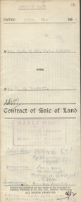
Document - H.A & S.R. WILKINSON COLLECTION: CONTRACT OF SALE
This business was owned by father and son, Henry Archibald Wilkinson and Samuel Ronald "Ron" Wilkinson. Henry (1882-1954) was born in Shepparton and died in Bendigo. He was married to Grace Hovendon in 1908. Samuel Ronald "Ron" (1914-1995), Henry's son, was married to Florence Jean McKerlie in 1937.Contract of sale of land dated 29th May, 1954 between Mrs. E.M. & Mr. H.A. Knight (sellers) and Mr. W.H. Randall (buyer) for land being lot 2 on plan of subdivision No. 19227 being parts of lots 27 and 28 on plan of subdivision No. 4134 being part of Crown allotment 97 and being the balance of the land comprised in certificate of titles volume 6441 folios 021 and 022 and situate Albion Street, Bendigo. Together with weatherboard dwelling and all sundry. Price 2,200 pounds.organization, business, h.a. & s.r wilkinson real estate -
 Phillip Island and District Historical Society Inc.
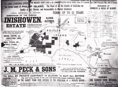
Map & Newspaper clipping, The Argus, Inishowen Estate, c1910 and 3/11/1868
Selection of land on Phillip island. Early subdivision of "Inishowen" Estate.449-01: Map of Phillip island showing "Inishowen" Estate c 1910 449-02: Newspaper article on the selection of land plus listing of people who obtained land. Argus 03/11/1868.inishowen estate phillip island, phillip island land selection 1868 -
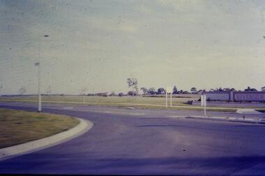 Greensborough Historical Society
Slide - Photograph, John Ramsdale, Riverside: Slide 1, 1990s
Photograph shows a new land subdivision, with the name "Riverside" on a wall.Part of the John Ramsdale collection of slides and audio visual material.Colour photograph scanned from slide.No maker's marks or captions -
 Greensborough Historical Society
Maps, Greensborough. Parish Plan 1860, 1860c
This plan show Green's subdivision of Greensborough, north of Grimshaw Street.Enlargements of Parish plan circa 1860?One copy possibly from 1860, containing lot numbers for a government road, now Main Street, and surrounding streets.greensborough, grimshaw street greensborough, edward bernard green -
Whitehorse Historical Society Inc.
Map, Burwood Road, Box Hill City, 15/02/1952 12:00:00 AM
Detailed map of subdivision along the north side of Burwood Road, Box Hill between Station Street and Middleborough Road.Detailed map of subdivision along the north side of Burwood Road, Box Hill between Station Street and Middleborough Road. Shows many block owners, types of buildings, nature of fencing. Marked as 'Survey Plan No 5440'.Detailed map of subdivision along the north side of Burwood Road, Box Hill between Station Street and Middleborough Road. maps, burwood road, burwood, andrews street, greenwood street, tennyson street, middleborough road, station street -
Whitehorse Historical Society Inc.
Legal record - Land Title, Certificate of title
Certificate of Title to Florence Mabel laurie for land in Middleborough Road Blackburn North and transfer of land from Chemical Plastics Limited to De Stoop (Aust) Pty Limited plus maps of some subdivisions of the estate, 1942.Certificate of Title to Florence Mabel laurie for land in Middleborough Road Blackburn North and transfer of land from Chemical Plastics Limited to De Stoop (Aust) Pty Limited plus maps of some subdivisions of the estate, 1942.Certificate of Title to Florence Mabel laurie for land in Middleborough Road Blackburn North and transfer of land from Chemical Plastics Limited to De Stoop (Aust) Pty Limited plus maps of some subdivisions of the estate, 1942.land titles, laurie, florence mabel, chemical plastics limited, de stoop (aust) pty limited, middleborough road blackburn north, koonung creek, chapman street blackburn north, vivian street blackburn north, nestor grove blackburn north, joseph street blackburn north -
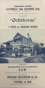 Kew Historical Society Inc
Document, Executor's Auction, Sunday 24th October 1931, "Goldthorns", Normanby Road, Corner of Argyle Road, Kew, 1931
Rare real estate brochure relating to the sale of a historically significant Kew mansion. The rarity the document is increased due to the photographs of the front of the house and of the extensive rear garden.Four page flyer advertising the sale of Goldthorns in Normanby Road, Kew in October 1931. The flyer contains a photograph of the front of the house, a list of its rooms, a site plan (including possible subdivisions). and a photo of the rear garden.goldthorns - normanby road, kew (vic), real estate - kew (vic), griffith family - kew (vic), gardens - kew (vic), subdivisions - kew (vic) -
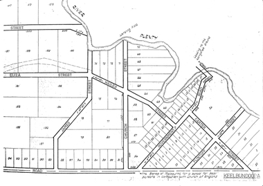
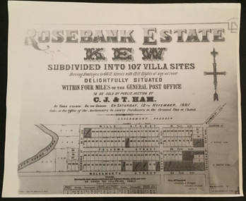 Kew Historical Society Inc
Plan - Subdivision Plan, Rosebank Estate, Kew
This work forms part of the collection assembled by the historian Dorothy Rogers, that was donated to the Kew Historical Society by her son John Rogers in 2015. The manuscripts, photographs, maps, and documents were sourced by her from both family and local collections or produced as references for her print publications. Many were directly used by Rogers in writing ‘Lovely Old Homes of Kew’ (1961) and 'A History of Kew' (1973), or the numerous articles on local history that she produced for suburban newspapers. Most of the photographs in the collection include detailed annotations in her hand. The Rogers Collection provides a comprehensive insight into the working habits of a historian in the 1960s and 1970s. Together it forms the largest privately-donated collection within the archives of the Kew Historical Society.Rosebank Estate (Kew). A photographic reproduction of a plan in the Vale Collection of the State Library of Victoria made for the historian Dorothy Rogers. This plan is a later version of the original subdivision plan after a number of lots had been sold.rosebank estate (kew), studley park, thomas ham, c.j. & t. ham, rosebank estate, kew, wills street, barry street, fellows street, redmond street, molesworth street, thomas wills, wills family -
 Kew Historical Society Inc
Plan, Gwen McWilliam, Annotated Plan of Kew & Hawthorn, 1993
Gwen Barton McWilliam (nee: Nelson), OAM, BA (1933- ). Gwen McWilliam is well known as an authority on the history of Boroondara and the author of a large number of books and pamphlets about the City. She was awarded the medal of the Order of Australia in 2001 ‘for service to the community of Hawthorn and district, particularly through the research, documentation and publication of its history.’ Plan of Kew and Hawthorn, forming part of a larger plan of the City of Boroondara, including annotations by the historian Gwen McWilliam, identifying significant landholdings, subdivisions and key dates. The plan was donated to the Kew Historical Society by Ms McWilliam. city of boroondara, subdivisions - hawthorn, subdivisions - kew, gwen mcwilliam -
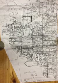
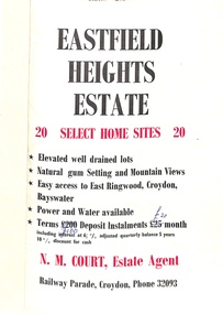 Ringwood and District Historical Society
Flyer, Land Sale Brochure, Eastfield Heights Estate, Croydon. (Undated, circa 1950s)
Bi-fold advertisement for 20 residential allotments with locality map of East Ringwood-Croydon area and map of subdivision bounded by Eastfield Road, and The Pass, Croydon. Agent - N.M. Court, Railway Parade, Croydon, Phone 32093. -
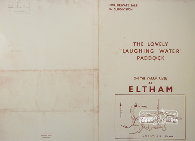 Eltham District Historical Society Inc
Photograph, For Private Sale in Subdivisions; The Lovely "Laughing Water" Paddock on the Yarra River at Eltham
Private sale of the "Laughing Water" paddock in subdivision; 5 river frontages with weatherboard villa on Lot 8; 6 woodland blocks of 5 and 6 acres. Sole Agent: Edward Haughton, 379 Collins Street, Melbourne Location plan and subdivision mapA3 colour photographic print from digital image of sales brochure and A4 reproduction of price listlaughing waters, edward haughton, real estate agent, eltham -
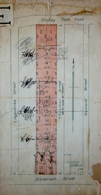 Kew Historical Society Inc
Plan - Subdivision Plan, Thornton Estate, 1918
The ‘Thornton Estate’ was the final subdivision of ‘Thornton’ in Studley Park Road. Thomas Cubitt Balmain originally owned Thornton, next to John Carson’s ‘Clutha’. Before its final subdivision, the Thomson family owned it. The Estate was a subdivision of 15 residential allotments running between Studley Park Road and Stevenson Street. The allotments faced these streets as well as Thornton Street, which the vendor undertook to make. Contemporary newspaper advertisements advised that ‘The estate possesses many advantages, notably its private and secluded, though convenient, position, splendid frontages and depths, and being close to the electric tram and Kew train, also within easy walking distance of the Victoria-street cable tram’. The terms offered purchasers were ten per cent deposit, with the balance to be paid in ten equal half-yearly payments at a rate of 5 per cent.subdivsion plans - kew, studley park, thornton estate -
 Lakes Entrance Historical Society
Photograph, Holding M, 2006
Property and subdivision believed to have been done by Bill and Kaye Reddenbach.Colour photograph of early stage of residential development showing roadways formed through property, drainage pipes placed ready for installation, street lighting in place. Photograph taken from school, looking east. Swan Reach Victorialand development, housing -
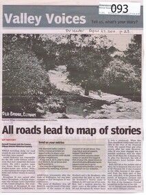 Greensborough Historical Society
Newspaper - Newspaper clipping, All roads lead to map of stories, 27/04/2011
Family history of Josiah Holloway, origins of street names in the subdivision of Eltham History of Eltham and origins of street names connected with pioneers of the area.Newsprint, gray scale. Photograph of Keylock's Bridge on Diamond Creek at ElthamDV Leader April27 2011, p23josiah holloway, jack shallard, susanna maria bible, bradbury, henry brougham, handfield, fay harcourt, violet bank, kangaroo ground, bells hillroad, shalbury avenue, beard street, brougham street, main road, eltham -
Glenelg Shire Council Cultural Collection
Administrative record - Administrative record - Proposed Heritage Valley Subdivision, 15/04/1992
Two lined sheets of paper, Elder's Real Estate logo top left, photocopies. Contain lists of lot numbers, area and price of blocks in proposed Heritage Valley subdivision. a) is an updated list and b) a further updated list -
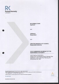 Bendigo Historical Society Inc.
Document - Gemma Starr collection - Bendigo East Primary School - VCAT submission for the hearing of Ms. Gemma Starr vs Terraco and the Greater Bendigo City Council regarding the subdivision of the former Bendigo East PS site
Gemma Starr collection - Bendigo East Primary School - documents supporting the VCAT submission for the hearing of Ms. Gemma Starr vs Terraco and the Greater Bendigo City Council regarding the subdivision of the former Bendigo East PS site.social, local history, bendigo east primary school, planning obiections -
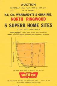 Ringwood and District Historical Society
Flyer, Land Auction, Cnr Warrandyte and Oban Roads, North Ringwood, Vic. - 1974
Single yellow page advertising Auction of five home sites to be sold separately on Saturday, 11th May, 1974. Details include vendor terms, subdivision services, and location map (north-east corner of Warrandyte and Oban Roads).(Agent) Eric Weber & Co. Pty. Ltd., 148 Wellington Parade, East Melbourne, 3002, Phone: 416025, Mr Elliott A.H. 8577502. Later handwritten notation suggests vendor was possibly Country Roads Board (VicRoads) after completion of road widening works. -
 Kew Historical Society Inc
Plan - Subdivision Plan, 10 Fine Villa Sites: Ermington Estate, Kew Heights, ca. 1917
Pru Sanderson, in her groundbreaking ‘City of Kew Urban Conservation Study : Volume 2 - Development History’ (1988), summarised the periods of urban development and subdivisions of land in Kew. The periods that she identified included 1845-1880, 1880-1893, 1893-1921, 1921-1933, 1933-1943, and Post-War Development. These periods were selected as they represented periods of rapid growth or decline in urban development. An obvious starting point for Sanderson’s groupings involved population growth and the associated economic cycles. These cycles also highlighted urban expansion onto land that was predominantly rural, although in other cases it represented the decline and breakup of large estates. A number of the plans in the Kew Historical Society’s collection can also be found in other collections, such as those of the State Library of Victoria and the Boroondara Library Service. A number are however unique to the collection.The Kew Historical Society collection includes almost 100 subdivision plans pertaining to suburbs of the City of Melbourne. Most of these are of Kew, Kew East or Studley Park, although a smaller number are plans of Camberwell, Deepdene, Balwyn and Hawthorn. It is believed that the majority of the plans were gifted to the Society by persons connected with the real estate firm - J. R. Mathers and McMillan, 136 Cotham Road, Kew. The Plans in the collection are rarely in pristine form, being working plans on which the agent would write notes and record lots sold and the prices of these. The subdivision plans are historically significant examples of the growth of urban Melbourne from the beginning of the 20th Century up until the 1980s. A number of the plans are double-sided and often include a photograph on the reverse. A number of the latter are by noted photographers such as J.E. Barnes.In November 1917, the Ermington Estate was advertised as an ‘Executor’s Sale’. It included the 10-roomed villa residence, ‘Ermington’, home of the late Mrs. Lorimer, and 10 ‘magnificent allotments’. The plan in the Kew Historical Society Collection is a little more specific. Ermington is described as having 9 Rooms &c. and there are 11 lots shown on the west side of Hillcrest Avenue. In the plan, the latter is named as ‘Hill Crest Avenue’. The plan indicates that the subdivision was based on the surveying work of Johnson & Tait. Opposite Ermington, the existing house ‘Parkhill’ is identified. A faded stamp on two parts of the plan indicates that it was in the possession of Jas. [R.] Mathers, Financial Agent, [136] Cotham Road, Kew.subdivision plans - kew, ermington heights estate - kew heights -
 Eltham District Historical Society Inc
Negative - Photograph, Coghill & Haughton, Stanhope Estate, Eltham; great suburban subdivisional auction, New Year's Day - Tuesday 1st January 1924, 1923
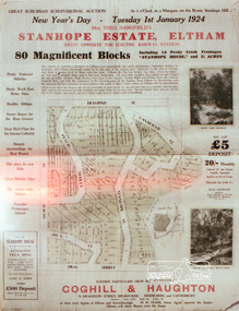
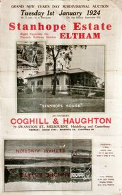
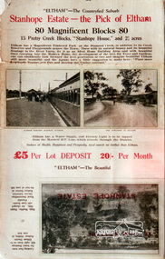
Subdivision of Stanhope property into 80 blocks; auction sale 1 Jan 1924 Roll of 35mm colour negative film, 3 stripsKodak CL 200 5093butcher, coghill and haughton, eltham, eltham railway station, railway station, real estate agent, stanhope estate, stanhope house -
 Eltham District Historical Society Inc
Negative - Photograph, Coghill & Haughton, Stanhope Estate, Eltham; great suburban subdivisional auction, New Year's Day - Tuesday 1st January 1924, 1923
Subdivision of Stanhope property into 80 blocks; auction sale 1 Jan 1924 Roll of 35mm colour negative film, 3 stripsKodak CL 200 5093butcher, coghill and haughton, eltham, eltham railway station, railway station, real estate agent, stanhope estate, stanhope house -
Glen Eira Historical Society
Plan - Ristori
Real Estate leaflet for the subdivision sale of the Ristori Estate & Residence on 31/05/1919 by Yeo, Crosthwaite & Co. A map of the 24 subdivisions available plus a locality plan are included along with details of separate sale on 04/06/1919 of the weatherboard buildings, rooms, stables & glass house.house names, 'ristori', land sales, sewerage, glen eira road, brick houses, land subdivision, orrong road, glasshouses, yeo crosthwaite & co melbourne, ripponlea, stables, ristori estate, auctions, drainage, liscard street, st. georges road, balaclava road, glen huntly road, glenhuntly road, elsternwick station, hotham street, weatherboard buildings, elsternwick