Showing 1857 items matching "subdivisions"
-
 Ringwood and District Historical Society
Flyer, Subdivisional Land Auction Sale Brochure, Grand Central Estate, Ringwood, Vic. - 1924
Refer also to Reg. No. 5148 for 1925 auction sale of land also titled Grand View Estate situated further south in Ringwood.Double sided multi-folded page advertising public auction sale on Saturday, 5th April, 1924, of residential allotments highlighting local facilities, services and layout of the estate. Includes panoramic view over the estate and other local photographic images. Additional clipped copy of subdivison map on blue cardboard backing includes real estate sales notations.Subdivision includes Whitehorse Road, Rupert Street, Herbert Street. and Leonard Street. Agents - Knight & Harwood, 315 Collins Street, Melbourne, Phone 10615, 10616 Central, in conjunction with J.B. McAlpin, Opposite Railway Station, Ringwood. Phone Ringwood 7. -
 Ringwood and District Historical Society
Document - Folder, Land Sale - Monterey Park Subdivision, Warrandyte Road, Ringwood North, Vic. - 1981
Foolscap manilla folder containing double-sided flyer advertising residential subdivision development, including outline of local facilities and services, with locality map and layout of Monterey Park streets. Subdivision includes Parkwood High School, Tortice Drive, Heape Way, Appleberry Place, Stringybark Court, Conifer Court, Crawley Grove, Monterey Close (later Monterey Place), Lucy Place, Middlebrook Drive, Gahnia Close, Glanfield Court, Cone Close, Jull Parade, Pinus Close (later Pinetree Court), Radiata Close, Old Warrandyte Road, and entry from Warrandyte Road. Vendor - Jennings Industries Limited, 690 Springvale Road, Mulgrave, 3170, Phone 5618000. A4 enclosures with tables showing each allotment List Price, Builders Price, Cash Price and Terms Price. Information page headed "Form of Restrictive Covenant to be incorporated in Transfer" specific to Certificates of Title. Restrictive Covenant (summary): (Name/s) "... will not erect or construct or cause to be erected or constructed on the land hereby transferred (a) Any front boundary fence, other than a fence which does not exceed one metre in height unless the same is set back as least 1.5 metres from the front boundary and the same is effectively screened from that boundary by the planting of trees, shrubs or plants. (b) Any side boundary fence other than a fence which is set back at least 1.5 metres from the front boundary on which does not exceed 1 metre in height within 1.5 metres of the front boundary. (c) For a period of 5 years from the date hereof, any building on the said land unless and until the Plans and Specifications thereof have first been approved by the said Residential Developments Pty. Limited. (d) For a period of 2 years from the date hereof whilst the said land remains vacant any Signboard or Notice advertising the sale of the said lot or any other lot. These covenants shall appear on the Certificate of Title to issue for the said land and run with the land." -
 Eltham District Historical Society Inc
Document - Folder, Bridgeland Estate, Eltham South, 1998
Various documents, including a history, letter and reminscences relating to properties of the Bridgeland Estate including Antoinette Boulevard and Leonard Crescent, Eltham South. 5 photocopies of parts of maps relating to subdivisions from 1842 to the 1925 Bridgland Park Estate Folders 78 and 80 from Harry Gilham Collection 12 pagesantoinette boulevard, leonard crescent, eltham south, bridgeland park estate, harry gilham collection -
 Luther College
Map, Plan of Subdivision, 1957
This map shows the original subdivision of land on the corner of Plymouth Road and Yarra Road. The land previously belonged to Phillip Brucker, who used the property as a small farm. Brucker offered his land at a reduced price to the Lutheran Church, who were seeking a location for their new secondary school endeavour.This is the oldest map of Luther Collegemap, building plans -
 Melton City Libraries
Photograph, West Melton-Coburns Road, 1969
Coburns Road - 19th c family descendents living in Melton. Coburn Primary School Cr George Coburn. 1930’s. December 1935 Shire President Cr Geo Coburn convened meeting to form the Bush Fire Brigade. Road construction of Service road and beginnings of West Melton subdivision. West Melton-Early Division View of Coburns Road. council, local significant events -
 Bacchus Marsh & District Historical Society
Map, Coimadai Parish Map, County of Bourke. Circa 1890s-1900s
The cadastral Parish of Coimadai, a subdivision of the County of Bourke, lies directly north of the township of Bacchus Marsh. The date of this map is uncertain. T.F. McGauran the person who made a photo-lithographic copy of the map was in charge of photo-lithography at the Victorian Department of Lands and Survey in the late 19th century until about 1910.A single page paper map showing the map for the Parish of Coimadai in the County of Bourke. A cadastral map showing parish boundaries and land ownership. A rectangle shaped area is missing from the centre of the map due to a tear or deliberate excision. The map is pasted into a bound volume containing 76 maps or plans in total. High resolution digital image stored on BMDHS computer network. Photo-lithographed at the Department of Lands and Survey, Melbourne by T.F. McGauran 26.8.[??] NOTE. Photo litho from L.P showing temporary surveys and occupation of land prepared for departmental use onlybacchus marsh region parish plans, coimadai parish maps, coimadai parish plan -
 Bendigo Historical Society Inc.
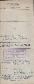
Document - H.A. & S.R. WILKINSON COLLECTION: CONDITION OF SALE
Contract of sale of land dated 23rd June, 1952 between Mr. J.L.C. Hunt (seller) and Miss D.A. Phillips for land being Lot 18 on plan of subdivision No. 14194, being part of Crown allotments 454A and 476 section H described in certificate of title volume 6110, folio 975 situate in Murray Street, Bendigo, together with 50roomed weatherboard dwelling and all sundry. Price 2,525 pounds.organization, business, h.a. & s.r wilkinson real estate -
 Kew Historical Society Inc
Plan, Gwen McWilliam, Annotated Plan of City of Boroondara, c.1995
Gwen Barton McWilliam (nee: Nelson), OAM, BA (1933- ). Gwen McWilliam is well known as an authority on the history of Boroondara and the author of a large number of books and pamphlets about the City. She was awarded the medal of the Order of Australia in 2001 ‘for service to the community of Hawthorn and district, particularly through the research, documentation and publication of its history.’ Digitally annotated part plan of the City of Boroondara, created by Council (Library?) staff, based on annotated plans provided by the historian Gwen McWilliam, identifying significant landholdings, subdivisions and key dates. On the plan Gwen McWilliam noted that the attempt to copy her annotations had resulted in incorrect data being included, so the plans were never published. For plans including her original 1993 annotations, see 2017.0143 and 2017.0144.Council markings in pinksubdivisions - hawthorn, subdivisions - kew, subdivisions - camberwell, subdivisions - balwyn, subdivisions - surrey hills, subdivisions - canterbury, gwen mcwilliam -
 Kew Historical Society Inc
Plan, Gwen McWilliam, Annotated Plan of City of Boroondara, c.1995
Gwen Barton McWilliam (nee: Nelson), OAM, BA (1933- ). Gwen McWilliam is well known as an authority on the history of Boroondara and the author of a large number of books and pamphlets about the City. She was awarded the medal of the Order of Australia in 2001 ‘for service to the community of Hawthorn and district, particularly through the research, documentation and publication of its history.’ Digitally annotated part plan of the City of Boroondara, created by Council (Library?) staff, based on annotated plans provided by the historian Gwen McWilliam, identifying significant landholdings, subdivisions and key dates. On the plan Gwen McWilliam noted that the attempt to copy her annotations had resulted in incorrect data being included, so the plans were never published. For plans including her original 1993 annotations, see 2017.0143 and 2017.0144.Council additions in pinksubdivisions - hawthorn, subdivisions - kew, subdivisions - camberwell, subdivisions - balwyn, subdivisions - surrey hills, subdivisions - canterbury, gwen mcwilliam -
 Kew Historical Society Inc
Plan, Gwen McWilliam, Annotated Plan of City of Boroondara, c.1995
Gwen Barton McWilliam (nee: Nelson), OAM, BA (1933- ). Gwen McWilliam is well known as an authority on the history of Boroondara and the author of a large number of books and pamphlets about the City. She was awarded the medal of the Order of Australia in 2001 ‘for service to the community of Hawthorn and district, particularly through the research, documentation and publication of its history.’ Digitally annotated part plan of the City of Boroondara, created by Council (Library?) staff, based on annotated plans provided by the historian Gwen McWilliam, identifying significant landholdings, subdivisions and key dates. On the plan Gwen McWilliam noted that the attempt to copy her annotations had resulted in incorrect data being included, so the plans were never published. For plans including her original 1993 annotations, see 2017.0143 and 2017.0144.Additions in pink by City of Boroondarasubdivisions - hawthorn, subdivisions - kew, subdivisions - camberwell, subdivisions - balwyn, subdivisions - surrey hills, subdivisions - canterbury, gwen mcwilliam -
 Bacchus Marsh & District Historical Society
Map, Subdivision of the Manor House Property Bacchus Marsh c.1908
This land sales plan shows allotments of land offered for sale in the inner township area of Bacchus Marsh in 1908. The land put up for sale was from the estate of the late Mr and Mrs J.E. Crook. That being James Elijah Crook and his wife Harriet, (nee Athorn). The Crooks had been resident in Bacchus Marsh since the 1840s and were prominent members of the community. They were prominent in the business, social and civic affairs of the town and district. In the 1850s the Crooks acquired the Manor House and nearby land once owned by the Bacchus family. James Crook died in 1889. When Harriet Crook died in February 1908 their estate was offered for sale. This included the large stone home known as the Manor House and various parcels of land including around 50 allotments of land near the Manor House, bounded by Young, Lerderderg, Crook and Main Streets. Most of these allotments of land were sold in October 1908. The Manor House itself was passed in at the sale and continued to be owned by the Crook family for several decades after 1908.A single page map on a single page of a bound volume of maps. The map shows portions of land for sale from the subdivision of the Manor House property in Bacchus Marsh in 1908. The names of most of the buyers of the portions of land have been hand-written into the various allotments they purchased. The maps are pasted into a bound volume containing 76 maps or plans in total. High resolution digital image stored on BMDHS computer network. bacchus marsh victoria maps, land sales bacchus marsh, manor house bacchus marsh, crook family bacchus marsh -
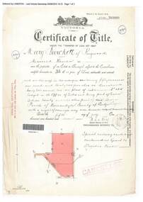 Ringwood and District Historical Society
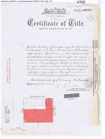
Document, Certificate of Title - Mary Burchett, Lilydale Road, Ringwood - part of Crown Section 20, Parish of Warrandyte, County of Evelyn - 5th July, 1911
A4 copies of Landata Victoria Historical Search documents - Vol 3520 Fol 703990.Mary Burchett of Ringwood, Married Woman, is now the proprietor of an Estate in Fee-simple subject to the Encumbrances notified hereunder ... 50 acres 1 rood 32 perches or thereabouts, being lots 1 and 10 on plan of subdivision no.4315. Subdivision map includes un-named roads - western side is Wonga Road (later Warranwood Road), and eastern side is Grandview Grove (later Bemboka Road), both north of Plymouth Road, Ringwood, Vic. Title transferred to Theodore Hartley Burchett, 27th July, 1911. Encumbrance comment "Special railway condition contained in Grant to Francis Cooke." -
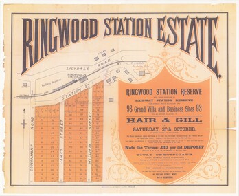 Ringwood and District Historical Society
Poster - Auction, Ringwood Station Estate, Ringwood, Victoria - circa 1925
Colour photocopy of poster sub-titled Ringwood Station Reserve & Railway Station Reserve. Auction of 93 sites on Saturday 27th October (no year, likely 1925). Subdivision includes Station Street, Government Road (Wantirna Road), James Street, William Street. Auctioneers - Hair & Gill, 16 Collins Street West and Glenferrie. Solicitor - Seymour Fergie, Elizabeth Street. Surveyors - Fowler & Gatward, 12 Collins Street West. -
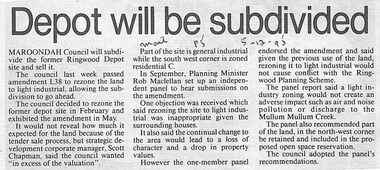 Ringwood and District Historical Society
Newspaper, Scrapbook Clipping, Library Collection, Ringwood, Victoria, `
``Newspaper clipping from "The Mail"5-12-95", P 5. Depopt will be subdivided. Maroondah Council will subdivide the former Ringwood Depot site and sell it. The council last week passed amendment 1.38 to rezone the land to light industrial, allowing the subdivision to go ahead. It would not reveal how much it expected for the land because of the tender sale process.` -
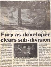 Ringwood and District Historical Society
Newspaper, Scrapbook Clipping, Library Collection, Ringwood, Victoria
Newspaper Clipping from "The Mail", 25-7-95. P3. Fury as developer clears sub-division. By Leonora Elliot-BruceConcerned conservationists have accused a developer of almost destroying vegetation to make way for a North Ringwood subdivision. The group, Friends of Loughie's Bushland, wants Maroondah City Council to investigate the developer's action which it claims has devastated the area. The developers are Barnsdale Forest -
 Greensborough Historical Society
Certificate of Title, Certificate of Title Vol. 3182 Fol. 302, 15/02/1907
Title in the name of Joseph Laidlay of Greensborough, fruitgrower, 14 acres being Lots 7, 8 and 22 on Plan of subdivision 4759, part of Crown portion 17, Parish of Keelbundora County of Bourke, dated 15th February 1907. Northern boundary Greensborough (now Grimshaw) Road, Eastern boundary Henry Street.1 p. colour copy of Titlegreensborough, grimshaw street greensborough, henry street greensborough, joseph laidlay -
![Map, Plan of Subdivision of Crown Portion 23 & parts 24-25, Parish of Korkuperrimul [1900s?]](/media/collectors/5e461d8021ea67224c82f2a1/items/675fe058304668462205d4fb/item-media/675fe0ef304668462205d7d6/item-fit-380x285.jpg) Bacchus Marsh & District Historical Society
Bacchus Marsh & District Historical SocietyMap, Plan of Subdivision of Crown Portion 23 & parts 24-25, Parish of Korkuperrimul [1900s?]
The Parish of Korkuperrimul includes a significant section of the township of Bacchus Marsh and extends in western and northern directions from the township area. The date of the subdivision indicated on this plan has not been established. The engineer's stamp on the drawing shows the firm of Muntz and Muntz who were operating under that name in the early part of the 20th century.A single page paper map showing 20 blocks of land for sale in the Parish of Korkuperrimul. Scale 100 feet to 1 inch. The map is pasted into a bound volume containing 76 maps or plans in total. High resolution digital image stored on BMDHS computer network. Stamped: 'Muntz & Muntz Civil Engineers, Architects & Surveyors, Trustees Chambers ?? Cor Collins Street and Bank Placeland sales bacchus marsh, bacchus marsh victoria maps, land sales korkuperrimul parish -
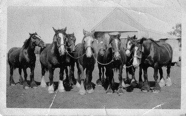 Hymettus Cottage & Garden Ballarat
Photograph, Archie Burke's Ploughing Team Dooboobetic
Mr William Burke settled at Dooboobetic near Donald in the 1860s his sons eventually working their own farms on subdivisions of the original property. Archibald (Archie) whose team is pictured had a portion named "Inverleigh". His daughter married Mr Michael Taffe of "Hymettus" Ballarat where the photographic archive survives. small snapshot image badly creased of team with inscription and print on reverse.Written on reverse "G'pa Burke's team. with printed words KODAK PRINT and ink stamp 431 -
 Eltham District Historical Society Inc
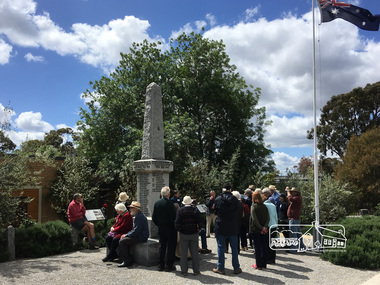
Photograph, Peter Pidgeon, Eltham War Memorial, 903-907 Main Road, Eltham, 4 November 2017, 4 Nov 2017
Eltham District Historical Society heritage walk to follow the boundaries of the original Shillinglaw Farm in central Eltham, held Saturday, 4th November, 2017. The Shillinglaw Farm comprised Lot 90 of Holloway’s 1851 Little Eltham subdivision. It was originally 30 acres in area and situated east of the Diamond Creek and north of Henry Street.Born digital imageeltham war memorial, obelisk, war memorial buidings, war memorial hall -
 Eltham District Historical Society Inc
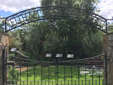
Photograph, Peter Pidgeon, Eltham War Memorial, 903-907 Main Road, Eltham, 4 November 2017, 4 Nov 2017
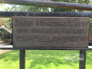
Eltham District Historical Society heritage walk to follow the boundaries of the original Shillinglaw Farm in central Eltham, held Saturday, 4th November, 2017. The Shillinglaw Farm comprised Lot 90 of Holloway’s 1851 Little Eltham subdivision. It was originally 30 acres in area and situated east of the Diamond Creek and north of Henry Street.Born digital imagecr. e.j. andrew, eltham war memorial, ernie andrew, war memorial buidings, war memorial garden, war memorial gates -
 Eltham District Historical Society Inc
Photograph, Peter Pidgeon, Eltham War Memorial, 903-907 Main Road, Eltham, 4 November 2017, 4 Nov 2017
Eltham District Historical Society heritage walk to follow the boundaries of the original Shillinglaw Farm in central Eltham, held Saturday, 4th November, 2017. The Shillinglaw Farm comprised Lot 90 of Holloway’s 1851 Little Eltham subdivision. It was originally 30 acres in area and situated east of the Diamond Creek and north of Henry Street.Born digital imagecr. e.j. andrew, eltham war memorial, ernie andrew, war memorial buidings, war memorial garden, war memorial gates -
 Greensborough Historical Society
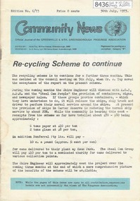
Newsletter, Greenhills and North Greensborough Progress Association, Community News: official journal of the Greenhills and Nth. Greensborough Progress Association. 30 July, 1973. Edition No. 6/73, 30/07/1973
This edition includes a report on the Progress Association's July 1973 meeting, Councillor's report, Re-cycling Scheme to continue, In the public interest, The subdivision of our district, Open forum, School and Kinder news, Letter to the Editor, Eltham Film Society, Churinga news. A digital copy of this Newsletter is available from Greensborough Historical Society.Newsletter, 24 p., illus.greenhills and north greensborough progress association, greenhills -
 Ringwood and District Historical Society
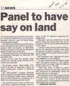
Newspaper, Scrapbook Clipping, Library Collection, Ringwood, Victoria
Newspaper Clipping from "The Mail", 3-10-95. P23. By Andrew Meath. Panel to have Say on LandAn independent panel will decide whether a housing subdivision in an environmentally sensitive part of North Ringwood should proceed. The Ministry of Planning and Development will appoint the panel to consider a request from developers of Barnsdale Forest to divide one acre (0.4 hectares) parcels of land into 7 lots -
 City of Moorabbin Historical Society (Operating the Box Cottage Museum)
Book, E-Gee Printers Pty.Ltd, Local History : Carrum to Cheltenham, 1999
A small softcover book dark green in colour at the top of the front cover is the authors name written in purple and the book's title written in large red letters there is also a charcoal drawing of a person driving a horse and dray with what looks like sacks of produce in the back on the back cover is text by the author and three reviews by different people.The book also contains a lot of old black and white photos of the family and places of note in the area.cheltenham, kingston, pioneers, moorabbin, carrum, mordialloc, picnic, asylum, hobsons bay, brighton, beach boxes, bridge hotel. -
 Warrnambool and District Historical Society Inc.
Map - Maps, Soldiers Settlement WW2, Circa 1950
The soldiers' settlement scheme operated after the first and second world wars in an effort to more closely settle the land and also give opportunities to returned soldiers. Crown land and other larger estates were acquired for the purpose. Most of these maps relate to the area north of Warrnambool where many of the subdivisions were parts of larger estates.These maps pertaining to the Soldiers' Settlement program, relate to an interesting part of Australian and local history. As such they have historic and social interest and significance.A collection of 25 paper maps which relate to to the soldiers settlement post World War 2. Some have details of the people allocated the land and some smaller maps have the printed details of the applicants requirements.Text is black on white paper which in some cases is quite aged. The maps are as follows: .1 Narrapumelap Estate ( Ripon & Hampden) .2 Narrapumelap Estate Part 2 (Villers & Ripon) .3 Narrapumelap Estate Part 3 ( Villiers & Ripon) .4 Burrumbeet Estate ( Ripon) .5 ' Berrambool' Estate 9 Hampden & Villiers) .6 ' Hopkins Hill' Estate Villiers 4011 acres .7 Caramut North No 2 Estate ( Villiers ) .8 ' Morpor' Estate ( Villiers) 4172 acres .9 ' Morgiana' Estate ( Normandy) 3453 acres .10 ' Chatsworth House' ( Villiers) 9341 Acres .11 ' East Elwood' Estate Villiers 2407 acres .12 Grey's Estate ( Mornington) 1151acres .13 ' Rowes Estate' ( Buln Buln Gippsland 733 acres .14 'Tarrone' Estate No 2 Part map .15 'Chaldon Meade' Estate (Bourke) Bulla 517 acres .16 ' Terranallum South' Estate Hampden 3757 acres .17 ' Brung Brungle' Estate Dundas 695 .18 ' Armidale ' Estate ( Dundas)2108 acres .19 ' Moyne Falls' Estate ( Villiers) 627 acres .20' Yulong' Estate 9 Lowan 6321 acres .21 Murray Valley Irrigation District 9 Moira)113 acres .22 Murray Valley Irrigation District 103 acres .23 ' Mount Fyans' Estate ( Hampden) .24 ' Barwidgee ' Estate ( Villiers) 4277 acres .25 'Pine Hills' Estate 2nd portion ( Lowan) 6190 acres narrapumelap, berrambool, hopkins hill, caramut north, morpor, chatsworth house, east elwood, terrinallum, moyne falls, tarrone, caramut soldiers settlers, burrumbeet, morgiana, grey's estate mornington, chaldon meade, brung brungle -
 Lake Bolac & District Historical Society
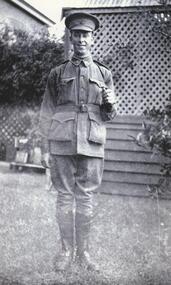
Black and white photograph, Gunner Stanley Herbert Moreton, Field Artillery Brigade, WW1
Gunner Stanley Herbert Moreton, enlisted 04/12/1916 in a Field Artillery Unit. He embarked for France on 11/05/1917. Upon his return from the war, he purchased 'Parupa Park'. After WW2 Stanley was involved in helping with the subdivision of land for soldier settlement. He died in 1978 at the age of 85.moreton, field artillery unit, 'parupa park', soldier settlement, -
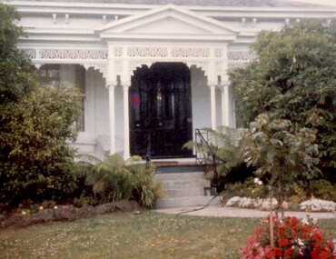 Surrey Hills Historical Society Collection
Photograph, 101 Guildford Road, Surrey Hills
The house was built in 1883, possibly to encourage development of housing on the first urban land subdivision in Surrey Hills, the Windsor Park Estate (in the Windsor Crescent area). This coincided with the opening of the Surrey Hills Railway station. The first occupant was John Brown Nicholson, police magistrate. In 1884 the foundation meeting of the Wyclif Congregational Church was held in the house.Colour photo of the front door and verandah of 101 Guildford Road taken from the street. The house is Victorian in style with ornate lacework along the verandah. It is painted white and has a slate roof. There is a well-maintained garden with flower beds and shrubs, which partially obscure the house.victorian style, wyclif church, houses, guildford road, john brown nicholson -
 Bendigo Historical Society Inc.
Document - H. A. & S. R. WILKINSON COLLECTION: CONTRACT OF SALE
Contract of sale of land dated 12th July 1955 between Mr. C. Naismith (vendor) and Mr. J. M. Parsons (purchaser). Property: land being lot 20 on plan of subdivision No. 22101 part of Crown allotment 60 section D Parish of Mandurang, County of Bendigo and being land described in certificate of title volume 7925 folio 69 and situate Archer Street, Kangaroo Flat. Price: 140 pounds.organization, business, h.a. & s.r wilkinson real estate -
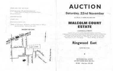 Ringwood and District Historical Society
Flyer, Land Auction Brochure, Malcolm Court Estate, Ringwood East, Vic. - 1969
Bi-folded single sheet with black print both sides advertising Auction on Saturday, 22nd November, 1969. Details include location map, vendor terms, subdivision features and local facilities. Centre page shows allotment numbers and property dimensions. Agent - Whitehorse Real Estate, 1123 Whitehorse Road, Box Hill, (Phone) 890502, After hours 8781429. Separate copy of map with handwritten sale notations for some allotments.LP 859686 -
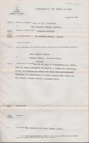
 Wonga Park Community Cottage History Group
Document - Title History, Title History of Crown Allotment 9A Wonga Park
The allotment history for Crown allotment 9A Wonga Park (after Crown leases from 1893) starts in 1906 with the Crown granting 46 acres and 6 perches to Thomas Shaw, an iron worker in Collingwood. The history of registered owners who have a connection with the allotment include Charles James Phair (1920), Victor Sydney Hollow, Ellen Nora Taubman, Norman Edward Taubman, Ethel Clara Taubman, Norman Hugo Semmler, Dulcie Margaret Semmler, Wesley Charles Robinson, Margaret Joyce Robinson, Roslan Pty Ltd, Aktip Pty. Ltd., Hendricus Martinus Versteegen, Marie Therese Versteegen, Gary Grey Hutchins and Annette Louise Hutchins, Frederick Allen Lang, Beverley Elizabeth Lang, Gary John Cole, Kay Jean Cole, Trevor James Lethlean and Rosalie Dawn Lethlean, inter alia.Archive file for Crown allotment 9A containing title history documents and research. Documents include copies of Crown Grant Volume 3161 Folio 174, Certificates of Titles Volume 9274 Folio 298, Volume 9274 Folio 299, Volume 9274 Folio 300, Volume 9538 Folio 560, Volume 10155 Folio452, Volume 10155 Folio 453, Volume10177 Folio 343, Plan of consolidation No. 354507C and Plan of Subdivision No. 331410J