Showing 39151 items
matching surveyors-camp-east-gippsland
-
 Federation University Historical Collection
Bag, Monash University Gippsland / University of Ballarat Carry Bag, 2013, c2013
Federation University Australia was established on 1 January 2014. Formerly known as the University of Ballarat, its enabling legislation was the University of Ballarat Amendment (Federation University Australia) Act 2013. Although formally created as a University in 1994, the University of Ballarat has a lineage back to 1870 with the establishment of the School of Mines Ballarat, making it the third institution of higher learning to be established in Australia and the first to be established in regional Australia. On 1 January 1994, Ballarat University College became the University of Ballarat and in 1998 the University merged with three TAFE Institutes to become a dual sector institution with multiple campuses. On 1 January 2014, the University of Ballarat amalgamated with the Monash University Gippsland Campus to form Federation University Australia. The Gippsland Campus also had a long lineage dating back to 1928 with the establishment of the Yallourn Technical School which became a predecessor institution to the Gippsland College of Advanced Education formed in 1968. In 1990, it was renamed the Monash University College and in 1993 became the Gippsland Campus of Monash University. In 2016, Federation University Australia announced plans to take possession, over a two-year period, of Monash’s Berwick Campus in the south-east corridor of Melbourne. Federation University Australia, or FedUni, is headquartered in Ballarat and offers programs in Higher Education and Vocational Education and Training to regional Victoria and beyond. The University’s commitment to educational and social equity, teaching excellence, research distinction, environmental sustainability and regional capacity building has enabled it to develop in a way that draws on its proud heritage to inform its future. Its regional character sets a framework for the University’s priorities but does not constrain it from serving wider community interests, nationally and internationally. The name Federation University Australia was chosen to convey the scope and capacity of an expanded regional university with a federated network of campuses.White bag with blue writing used durinng 2013 Open Day. The Monash Univeristy Gippsland Campus and University of Ballarat became Federation University Australia in 2014.monash university gippsland, university of ballarat, open day, federation university australia -
 Sunbury Family History and Heritage Society Inc.
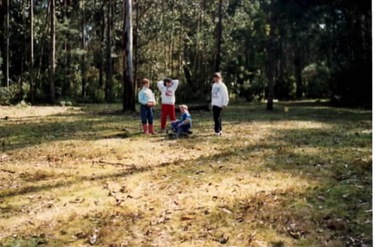
Photograph, Gundiwindi School camp, 14th - 18th August 1989
The photograph was taken in 1989 when students in Grades 4 and 5 from Bulla Primary School attended a school camp at Gundiwindi Camp. The camp is in the Yarra Valley area on the border of North Wandin and Silvan. At the camp the children were learning bush survival skills, which were practised by the local indigenous people.The emphasis on the camp at Gundiwindi was bush survival and skills used by indigenous people.A non-digital coloured photograph of four children in a bushland setting attempting to build a camp fire in the cleared area. the forested area is behind the group.school camps, gundiwindi, bulla primary school, indigenous culture -
Lakes Entrance Historical Society
Book, Bird, Eric and Lennon, Jane, Making an Entrance- The Story of the artificial entrance to the Gippsland Lakes, 1989
Revised edition of an earlier publication 'The Entrance to the Gippsland Lakes'. Contains illustrations, Maps, Diagrams timed for the centenary of the opening of the artificial entrance at Lakes Entrance VictoriaRevised edition of an earlier publication 'The Entrance to the Gippsland Lakes'. Contains illustrations, Maps, Diagrams timed for the centenary of the opening of the artificial entrance at Lakes Entrance Victoriaexploration, coast, transport, civil engineering -
 Ringwood and District Historical Society
Photographs, East Ringwood Shops in Railway Avenue circa 1980s (6 photos), 1997
Colour photos of the Ringwood East shopping centre. Query drainage works and autumn trees.East Ringwood shops - hardware shop at roundabout (3274_001); East Ringwood shops - post office (3274_002); East Ringwood shops - Paul's supermarket (3274_003); East Ringwood shops - unknown street (3274_004); East Ringwood shops - Lawrence Grove corner (3274_005); East Ringwood shops - Wright Bros (3274_006) -
 Kew Historical Society Inc
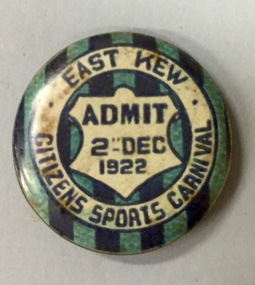
Badge - Fundraising Button, East Kew Citizens Sports Carnival, Admit 2nd December 1922, 1922
Most of the ephemera assembled by Francis Rigg were patriotic buttons but also included come sporting event buttons including two associated with the East Kew Citizens Sports Carnival. The subdivision of the area now known as Kew East commenced before World War 1, but it was not until the 1920s that it became fully developed. At this time, there was a strong Progress Association and this body raised funds to purchase land and build the East Kew Citizen’s Hall in Normandy Road, the first stage of which was completed in 1922. This hall was designed to be extended, although this never occurred, and the building now forms part of the facilities of the East Kew Uniting Church. The ‘East Kew Citizens Sports Carnival’ may well have been a fundraiser event for the building fund. As far as is known, the carnival was only held for a couple of years.Frances Rigg was a local business identity in Kew, at one stage managing the local branch of the English, Scottish and Australian (ES&A) Bank at 175 High Street from c. 1920 until the 1940s. After Francis Rigg’s death, the collection of buttons and medallions was inherited by his son, Ken Rigg (1922-2014). The collection was subsequently donated to the Kew Historical Society in 2015 by Francis' grandson, Adrian Rigg, at the time of the Gallipoli & Beyond Commemoration in 2015. The collection covers a period of almost 40 years. The majority of the buttons are patriotic buttons, issued and sold during and immediately after the First World World War (1914-1918) to raise funds for national and overseas causes. The collection also includes a number of locally significant sporting event buttons and sporting club medallions, issued in the 1920s and 1930s.A circular button produced for the East Kew Citizens Sports Carnival in 1922. The button has a ground of vertical stripes in shades of blue. The name of the event is within a white circular band. A white shield in the centre that includes the words “Admit” would indicate that the badge was purchased and worn on the day of the carnival to indicate that the wearer had paid the admission fee. "East Kew Citizens Sports Carnival, Admit 2nd December 1922"east kew, east kew citizens sports carnival, sports, badge, numismatics, francis rigg -
 Wangaratta RSL Sub Branch
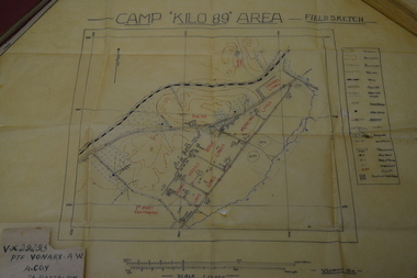
Work on paper - Field Sketch, Camp Kilo 89 Area
Hand sketch of 'Kilo 89' Camp in Palestine located in collection of assorted Army issued books and personal papers belonging to Private Alfred William VONARX VX29295 who was born 5/7/1901 at Docker Plains near Wangaratta. He enlisted on the 4/7/1940 at Seymour and served with the 2/7th Battalion in the Middle East during WW2. Written on back of sketch is - Pte B G HOY - Brian Goodwin HOY VX44031 born 20/4/1915 at Alphington.Detailed field sketch to scale of Camp Kilo 89 Area, Gaza Ridge in PalestineDetailed sketch to scale on cream coloured parchmentCamp Kilo 89 Area - Field Sketch Handwritten on rear - Pte B G HOYcamp kilo 89, palestine, ww2, alfred william vonarx, brian goodwin hoy, 2/7 infantry battalion -
 Red Cliffs Military Museum
Framed Photo Reproduction, Changi POW Camp 1942, 1942 (exact); Photo taken 1942
Black & white reproduction photograph of Changi POW Camp in ornate wooden frame. Photograph shows variety of tents and structures in foreground and groups of figures in background. Vehicle with Red Cross emblem in background.On Photograph: 6-Bartack SQ,. Sept, 1942. Black tape on frame: Changi POW Camp 1942of, war, changi, prisoner, 1942, barrack -
 Kew Historical Society Inc
Administrative record, East Kew Women's Club, Attendance Register, 1967-1971
The East Kew Women’s Club was formed on 20 July 1945 as an experiment amongst local women, who felt that there was a need for some organised group to give full scope to their various interests and hobbies. In the beginning, they met at the house of their founder, Mrs Eric Thake, 48 Harp Road, East Kew, but the growth and interest was so rapid that it was soon necessary to find a larger meeting place, so the group moved to the Harrier’s Pavilion in Victoria Park, Kew. At the fifth meeting of the group, a committee was formed, and a constitution adopted on 4 December 1945.The Club was aimed to be non-political, non-sectarian and open to women from any locality. The Club’s motto was “To Help others, Improve Ourselves, and Foster the Community Spirit”. The first twenty years of the Club was recorded in a small, nine-page publication “East Kew Women’s Club : Twenty Years 20-7-1945 - 30-7-1965”. Following the closure of the Club in 1973, after twenty-eight years, its records were deposited with the Kew Historical Society and are thus available for research into the history of women’s groups in the post war period in Australia. The Society holds the Club’s Minute Books of Meetings (1953-73), Attendance Registers (1959-73), Visitors Book, and sundry items of print ephemera published by the Club.Register, East Kew Women’s Club, 1967-71east kew women's club, community groups -- kew east (vic.) -
 Orbost & District Historical Society
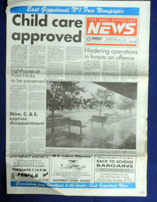
newspaper article, January 31 1991
On 24 January 1991 a severe hailstorm occurred in Orbost. The Insurance Council of Australia estimated the 1991 damage at $12 million.This is a contemporary record of a significant event in Orbost.The front and back page of The East Gippsland News dated Thursday January 1991. The main article is a photograph of the hailstorm damage to Nicholson Street in Orbost.hailstorm-orbost east-gippsland-news newspaper-article -
 Lakes Entrance Historical Society
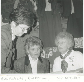
Photograph - Lakes Entrance Girl Guides, Lakes Post Newspaper, 1/05/1995 12:00:00 AM
Black and white photograph of Girl Guides Sue Roberts Reg Commissioner, Barb McGuire, Bev McColley taken at reunion East Gippsland Victoriagirl guides -
 Lakes Entrance Historical Society
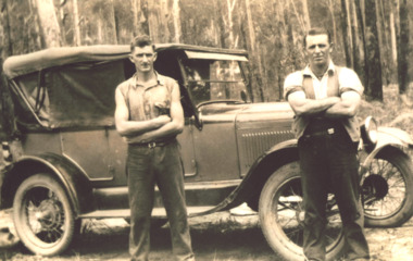
Photograph - T Model Ford, Charles Pettman and William Henry Flukes, 1936 c
The T Model Ford cost him 28 poundsBlack and white photograph of Charles Pettman and William Henry Flukes standing beside Charles T Model Ford on a forest track East Gippslandvehicles, topography -
 Orbost & District Historical Society
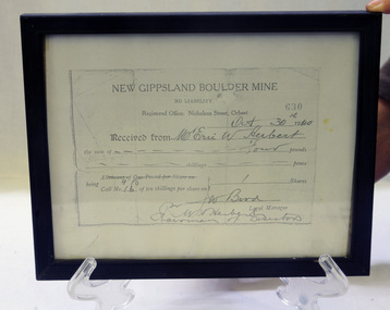
Certificate - share, 30/10/1940
Share certificate issued by New Gippsland Boulder Mine - operating at Errinundra and receipt for Herbert, Eric W. Receipt is for amount of four pounds - signed by Bird, W. Prospectus was printed in 1934 at office of Snowy River Mail - 4 page booklet. Gold, copper and silver were the target minerals.The crusher from the Boulder Mine is now at the Slab Hut in Orbost. The first Gippsland Boulder Co.,was at Boulder Creek – 13 miles north of Club Terrace, within 2 miles of Errinundra River. The company registered in January 1898 and commenced crushing in September with a 10-head battery. In the first nine months’ yields totalled 1,418 oz from 972 tons.There was a tramway between the mine workings and the battery.The crusher from the Boulder Mine is now at the Slab Hut in Orbost. This document is a reference for gold mining and exploration in the Far East Gippsland area. The Herbert family has reside in Orbost since the late 19th century.Copy of New Gippsland Boulder Mine share certificate and receipt. Framed in small black wooden frame.certificate-share-new-gippsland-boulder-mine mineralogy mining boulder-creek -
 Kew Historical Society Inc
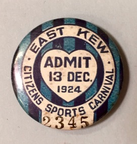
Badge - Fundraising Button, East Kew Citizens Sports Carnival: Admit 13 Dec. 1924, 1924
Most of the ephemera assembled by Francis Rigg were patriotic buttons but also included come sporting event buttons including two associated with the East Kew Citizens Sports Carnival. The subdivision of the area now known as Kew East commenced before World War 1, but it was not until the 1920s that it became fully developed. At this time, there was a strong Progress Association and this body raised funds to purchase land and build the East Kew Citizen’s Hall in Normandy Road, the first stage of which was completed in 1922. This hall was designed to be extended, although this never occurred, and the building now forms part of the facilities of the East Kew Uniting Church. The ‘East Kew Citizens Sports Carnival’ may well have been a fundraiser event for the building fund. As far as is known, the carnival was only held for a couple of years.Frances Rigg was a local business identity in Kew, at one stage managing the local branch of the English, Scottish and Australian (ES&A) Bank at 175 High Street from c. 1920 until the 1940s. After Francis Rigg’s death, the collection of buttons and medallions was inherited by his son, Ken Rigg (1922-2014). The collection was subsequently donated to the Kew Historical Society in 2015 by Francis' grandson, Adrian Rigg, at the time of the Gallipoli & Beyond Commemoration in 2015. The collection covers a period of almost 40 years. The majority of the buttons are patriotic buttons, issued and sold during and immediately after the First World World War (1914-1918) to raise funds for national and overseas causes. The collection also includes a number of locally significant sporting event buttons and sporting club medallions, issued in the 1920s and 1930s.A circular badge produced for the East Kew Citizens Sports Carnival in 1924. The badge has a ground of vertical stripes in shades of blue. The name of the event is within a white circular band. A white shield in the centre includes the words “Admit” which would indicate that the badge was purchased and worn on the day of the carnival to indicate that the wearer had paid the admission fee."East Kew Citizens Sports Carnival / Admit 13 Dec. 1924"kew east, sport buttons -
 B-24 Liberator Memorial Restoration Australia Inc
Map - Silk Escape Map, NO. C45 EAST BORNEO
These maps were used by Air crew in case of air craft crashing.Fabric map of East Borneo.AAF CLOTH CHART NO. C-45 EAST BORNEO (Other side Chart No. C-46) No.C-45 EAST BORNEO S120-E11340/540Nx520 -
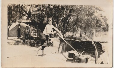 Melbourne Legacy
Photograph, Somers Camp, c1930
A black and white photo of a boy, Roy Gilbert, standing by cooking pots and a campfire at a beach camp. It is labeled Somers Camp so this was a very early camp using tents, before camp buildings were erected. In the early years, Legacy organised outings to the property of Legacy founder, Legatee Stan Savige, who had a place in Balnarring close to the beach. Permanent camp buildings were built in 1930. In 1930 Lord Somers (Governor of Victoria) also started a camp at a nearby property and the area was renamed Somers. Legacy Somers Camps continued intermittently at Stan's property until it was decided in 1951 to make other arrangements for holidays. This photo was with a group of photos from around the 1930s from the early days of Legacy, including cricket team, football team, and camps at Balnarring/Somers (saved as 01915 to 01934).Legatee Savige's property at Balnarring became very important for Legacy providing outings and camps for junior legatees.Black and white photo of a boy by cooking pots on a campfire.Handwritten 'Roy Gilbert Somers Camp' in blue pen. Stamped '39' on back in grey ink.beach, campfire, tents, savige property, legacy somers camp -
4th/19th Prince of Wales's Light Horse Regiment Unit History Room
Framed Photograph, Mena Camp -The 1st Australian Division, Australian Imperial Force - Egypt, 1914-15, abt 1915
On mobilisation, the Australian 4th Light Horse Regiment was originally destined to go to the Salisbury Plain UK for training. However the Australian troops were diverted to Egypt to defend the Suez Canal from a threat from Turkey. A camp was set up at Mena, near the Pyramids.Framed black & white photo of Mena Camp in wood frameMay your comradeship be as lasting as that still prevailing in our Regiment. With compliments from 4 ALH. -
 Tatura Irrigation & Wartime Camps Museum
Photograph, Con Mafalda, John and Val Fortuna Camp 3A December 1995
John and Val revisiting the site where they were internees in Camp 3 A during WW2.Colour photograph of a Con Mafalda, John and Val Fortuna sitting on the remains of a structure at Camp 3 in 1995.internment camp 3, italian internees camp 3, john fortuna, val fortuna -
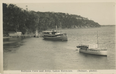 Lakes Entrance Historical Society
Postcard - S S Gippsland leaving Kalimna Jetty Lakes Entrance, H D Bulmer, 1930 c
S S Gippsland leaving Kalimna Jetty Holdens boat Sagitasse moored nearby Jemmys Point in distance Lakes Entrance VictoriaBlack and white postcard showing S S Gippsland leaving Kalimna Jetty Holdens boat Sagitasse moored nearby Jemmys Point in distance Lakes Entrance VictoriaKalimna Cove and Jetty Lakes Entranceislands, waterways, boats and boating, tourism -
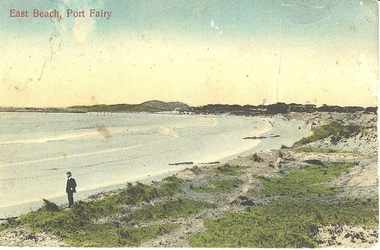
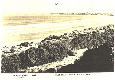 Port Fairy Historical Society Museum and Archives
Postcard, The Rose Series / The Rose Stereographs, East Beach, Port Fairy Victoria
Black and white Photograph of East beach looking East South East with dunes in the foreground and the bay and Griffith Island in the background taken for use as a postcardThe Rose Series P.1144. Copyright East Beach Port Fairy Victoriaeast beach, dunes, sea, ocean, griffith island -
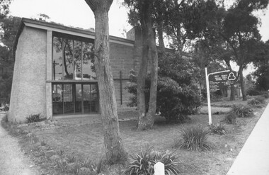 Ringwood and District Historical Society
Photograph, Holy Trinity Anglican Church Ringwood East 1973
Holy Trinity Anglican Church Ringwood EastWritten on backing sheet, "Rwd. East. 30.9.73" -
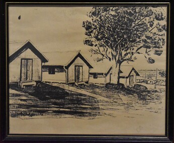 Tatura Irrigation & Wartime Camps Museum
Sketch - Copy, Barracks at Camp 2
Nicola Cua lived with his Italian parents in London. Interned when Italy came into the war as Germany's ally. Transported on "Dunera" to Australia to Camp 2. Photocopy of a sketch held in British Museum Records of Internment WW2Black and white sketch of four huts in foreground with gum tree centre front of 2nd hut on right side. On extreme right more huts are visible. Black frame - gold stripIndecipherablesketch, pen and ink, camp 2, tatura, ww2 camp 2, illustrations, pen, ink -
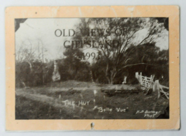 Orbost & District Historical Society
calendar, Old Views of Gippsland 1993, 1992
This item is a useful pictorial reference tool.A 1992 stapled pictorial annual calendar, titled "Old Views of Gippsland".On the front is a black/white photograph of "The Hut Belle Vue" taken by H.D. Bulmer. It contains early photographs of East Gippsland, one for each month. The photographs are sepia. There is a hole for hanging. Some dates have appointments recorded in pen.calendar-old-views-of-gippsland photographs-historic-gippsland -
 Port Fairy Historical Society Museum and Archives
Photograph - Postcard, East Beach Port Fairy
Shows old pier and remnants of wharf railEvidence of former pier and wharf railB&W PhotographEast beach Port Fairybeach, seascape, pier -
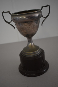 Warrnambool and District Historical Society Inc.
Trophy, 4/19 L H Camp 1938, 1930s
This is a trophy awarded at a camp of the 4/19 Light Horse Regiment. This regiment appeared to have been based in the Corangamite region of the Western District and included regiment members from Warrnambool. It is not known exactly what type of competition was an ‘Officers Flutter’. Light Horse regiments were cavalry regiments that were established at the time of the Crimean War in the 1860s. During the First World War the 4th Light Horse served with distinction in France, Gallipoli and Palestine. In 1948 the 17th Prince of Wales Light Horse, the 19th Yarrowee Light Horse and the 4th (ex 20th ) Corangamite Light Horse amalgamated to form a revived 4/19 Light Horse. This regiment kept alive the tradition of the original Light Horse units, becoming part of the Australian Army Reserve and members served in Vietnam and East Timor. This cup is of interest as an example of the trophies awarded for competition at a Light Horse regiment camp in the 1930s. This is a metal cup (silver amalgam)) with two side handles and a narrow stem attached to a silver base. The cup is attached to a brown Bakelite stand. The inside of the cup has some white paint streaks and the cup itself is much stained and pock-marked. ‘Westminster’ 4/19 L.H. Camp 1938 Officers Flutter light horse regiments. warrnambool district, history of warrnambool -
 Federation University Historical Collection
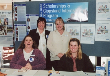
Photograph, Gippsland Campus Scholarship & Gippsland Internet Program, c2002
Gippsland Campus Scholarship & Gippsland Internet Program If you can assist with inforrmation on this photograph please use the email link below. gippsland campus collection, gippsland campus scholarship & gippsland internet program, display -
 Ringwood and District Historical Society
Plan, Plan of Subdivision No.11498 with handwritten costing notations - East Ringwood Central Estate c.1948
Two handwritten pages showing layout of Subdivision no 11498 with surveyor notations including property sizes and road construction cost calculations. Drainage easement 6 feet wide shaded blue.Plan of Subdivision No. 11498, Part of Crown Allotment 27, Parish of Ringwood, County of Mornington, (Certificate of Title Vol 5120 Fol 1023945). Owner Mr Vogel. Subdivision includes Knaith Road, Northwood Street, Langley Street, Bondi Street, and Government Road (later Alexandra Road), Ringwood East. G. Parsons & Sons, Licensed Surveyors, 389 Flinders Lane (Melbourne). -
Bialik College
Photograph (Item) - Grade 5 camp, c1990s
Estimated to be 1990s of a grade five camp. Students and teachers are shown relaxing in a shared indoor space, a beachside space, and a few individual images. For inquiries or access contact [email protected] side of the images have inscriptions 'Jean Year 5 Camp', 'tired teachers on year five camp', and lists students from 5D. 1990s, camp, grade 5, school, jewish school, bialik college, photographs. -
 Lakes Entrance Historical Society
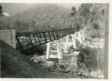
Photograph - Bridges, 1990
Also another photo taken laterColour photograph showing McKillops Bridge across the Snowy River in the High Country near Deddick, East Gippsland near the Victorian / NSW border, south side of bridge, road to Deddick just visible opposite end, taken from west end of bridge. River flowing to right, bridge of timber, steel and concrete, mountains around. East Gippsland Victoriabridges, waterways, topography -
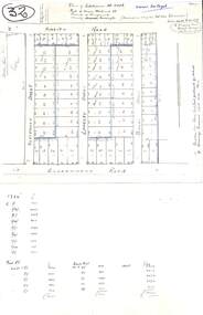
 Orbost & District Historical Society
plan, before 1948
Drainage infrastructure was developed and maintained in this region by the Snowy River Improvement Trust. The Trust was administered by a local committee and its activities funded by a local rate charged on the farmers and land owners in the Trust’s designated district. The level of the rate charged by the Trust was designed to be proportionate to the benefit derived from the works undertaken. Financial assistance was provided by the State Government from time to time for specific projects such as post flood repairs but not for new capital works. The Trust undertook new drainage and river management works including tree planting, rock beach construction and servicing of the drains and flood gates. The Trust also provided a personal flood warning service to the farmers in its district. The Trust ceased to operate in 1997 with the advent of the East Gippsland Catchment Management Authority. The infrastructure developed by the Trust continues to provide a service to the farmers in the region. (ref. 4 East Gippsland CMA Submission to Inquiry into Flood Mitigation Infrastructure in Victoria) This plan is significant as a historical document. The Snowy River Improvement Trust was vital to the Orbost district because of its ability to apply local knowledge and to engage the local farming community.A large plan of divisions of land for the purpose of levying the Snowy River Improvement District - Bete Bolong, Orbost, Waygara, Newmerella and Orbost East. The properties are coloured according to levy amount. The scale is 1" - 20 chains. snowy-river-improvement-trust -
 Federation University Historical Collection
Book, Camp Street Precinct Ballarat Conservation Management Plan (Draft), 1999, 10/1999
The conservation management plan was commissioned by the City of Ballarat to assist in the process of planning for the future management and development of the Camp Street precinct, having particular regard for the Camp Street Arts and Education Precinct.White, soft covered, spiral bound book relating to Ballarat's Camp Street Precinct. Contents include: Methodology, buildings and site layout. ballarat, camp street, clare gervasoni, ballarat fine art gallery, art gallery of ballarat, old colonists' hall, former ballarat mining exchange, former state offices, former police court, former police station, former police barracks, old police station, arts academy, archaeology, conservation management plan