Showing 2417 items
matching townships
-
 Marysville & District Historical Society
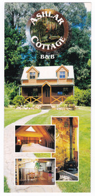
Flyer (Item) - Information flyer, Wayne Louk, ASHLAR COTTAGE B&B, Unknown
An information flyer regarding Ashlar Cottage B&B in Marysville. This cottage, along with the majority of the buildings in the township, was destroyed in the 2009 Black Saturday bushfires.An information flyer regarding Ashlar Cottage B&B in Marysville.marysville, victoria, australia, information flyer, accommodation, ashlar cottage b&b, 2009 black saturday bushfires -
 Phillip Island and District Historical Society Inc.
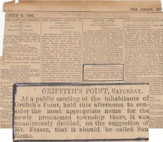
Newspaper clippings, The Age Newspaper, 1888
News item showing report of Public meeting to name township growing at Griffiths Point. Suggested by Mr Fraser that it be named San Remo. 1888Newspaper cutting with highlighted item "Griffiths Point Saturday" taken from The Age.July 9, 1888. No. 421local history, documents, newspapers, griffiths point, san remo, local area development, black & white newspaper clipping, newspapers san remo -
 Kiewa Valley Historical Society
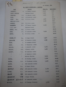
Papers - Mt Beauty Householders 1964, Mt Beauty Householders - Directory
Mt Beauty township was built in the late 1940s by the State Electricity Commission of Victoria for its workforce during the construction of the Kiewa Hydro Electric Scheme.This is a list of the early occupants of Mt Beauty township, naming the head of the household. It lists their phone numbers but not their occupations or family members.16 pages of Foolscap paper held by 2 staples in the top right hand corner. It consists of the following headings: - Name, Address, Phone No., and Sect-Allot.. The names are in alphabetical order. Commission owned houses are asterisked. All lists are as at 1st October, 1964Written in pen on top of first page "Patrol Supvr. - Info. Centre'mt beauty householders, mt beauty directory, mt beauty telephone directory, mt beauty residents 1964, mt beauty township -
 Marysville & District Historical Society
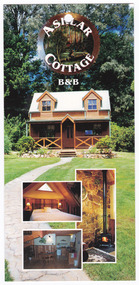
Flyer (Item) - Information flyer, Wayne Louk, ASHLAR COTTAGE B&B, Unknown
An information flyer regarding Ashlar Cottage B&B in Marysville. This cottage, along with the majority of the buildings in the township, was destroyed in the 2009 Black Saturday bushfires.An information flyer regarding Ashlar Cottage B&B in Marysville.marysville, victoria, australia, information flyer, accommodation, ashlar cottage b&b, 2009 black saturday bushfires -
 Donald History and Natural History Group operating the Donald Court House Museum
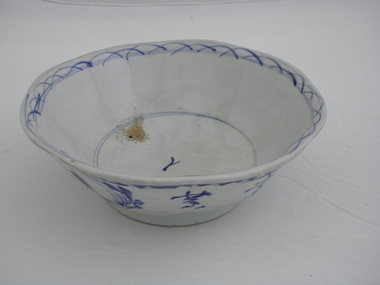
Bowl, Unknown Potter
Ceramic bowl found in hut belonging to Georgie Ah Ling, who operated a market garden for about 70 years on the edge of the township of Donald. Hand-molded blue and white ceramic bowl. Outside of bowl has underglaze blue decoration of flowers, leaves and Chinese characters. Saw toothed decoration, with one line underneath, around outside rim. Half moon shape lines, with two lines through them, decorate inside rim. Two lines around inside base with one Chinese character in centre of inside base.One Chinese character on inside base of bowl. Four Chinese characters and five plant symbols on outside of bowl. ceramic, bowl, hut, georgie ah ling, market garden, donald -
 Donald History and Natural History Group operating the Donald Court House Museum
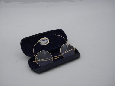
Spectacles and case
Reading spectacles found in hut belonging to Georgie Ah Ling, who operated a market garden for about 70 years on the edge of the township of Donald. Round glass, gold coloured wire framed spectacles in a hard covered case lined with dark blue material. Gold and dark blue suppliers sticker, partly torn, on inside lid of case.Sticker on inside of case partly torn, but probably reads "W. R. Swaby F.V.O.A. Jeweller Donald". reading spectacles, hut, georgie ah ling, market garden, donald -
 Lakes Entrance Regional Historical Society (operating as Lakes Entrance History Centre & Museum)
Postcard, H D Bulmer, 1940
Also two black and white postcards looking across footbridge to township 04271.1, 04271.2 size 9.5 x 14 cm 1940 cBlack and white postcard of Cunninghame Arm footbridge taken from the top of the sand dunes looking towards the few houses of Lakes Entrance Victoria Stamp on back The Lakes Studio Lakes Entrancebridges, recreational facilities, surf lifesaving, waterfront -
Bendigo Historical Society Inc.
Map - REDCASTLE : COUNTY OF BENDIGO, 10-8-08
Map. Redcastle, County of Bendigo, County of Rodney, Cornella, Cherrington, Dargile, Crosbie, Cornella Creek, Redcastle Creek, Mount Camel, Township of Redcastle. Photo-Lithographed at the Department. of Lands and Survey, Melbourne by T.F. McGaraun 10-8-08. (number 109 in map cupboard 1)T.F. McGaraunmap, bendigo, redcastle -
Bendigo Historical Society Inc.
Map - RAVENSWOOD : COUNTY OF BENDIGO, 1971
Map. Ravenswood, County of Bendigo, Township of Ravenswood, County of Talbot, Bradford; Walmer; Harcourt; Lockwood; Mandurang; Sutton Grange.By Authority C.H.Rixon, Government Printer, Melbourne.Drawn and Reproduced at the Dept. of Crown Lands and Survey, Victoria. 1971. Price $1.00 (number 5 in map cupboard 1)C.H.Rixon, Government Printermap, bendigo, ravenswood -
Clunes Museum
Photograph - PHOTOGRAPHS, VIEW IN TOWNSHIP, CLUNES, SOUTH EAST
Five reproduced black and white images of Clunes and surrounds; Camp Parade, Clunes South West View in Township, Clunes South East Port Phillip and Colonial Goldmining Company Victoria Quartz Mining Company Registered, Clunes Criterion Quartz Mining Company Registered Clunes clunes township, clunes mines -
Clunes Museum
Book, "THE PAKENHAM GAZETTE", MAIN STREET, PAKENHAM, A VALLEY OF THE FINEST DESCRIPTION, 1985
A SOCIAL AND ENVIRONMENTAL HISTORY OF LEXTON SHIRE.BLUE BOUND BOOK WITH THE SHIRE OF LEXTON SEAL IMPRINTED IN GOLD LETTERING ON THE FRONT COVER, COMPLETE WITH DUST JACKET DEPICTING AN IMAGE OF A HORSE TEAM ENTERING THE TOWNSHIP OF LEXTON WITH THE PYRENEES HOTEL AND THE LEXTON COURT HOUSE, DERIVED FROM A PAINTING BY ANN MCGREGORD OF BURNBANK. 360 PAGESnon-fictionA SOCIAL AND ENVIRONMENTAL HISTORY OF LEXTON SHIRE.local history, book, history, lexton -
 Clunes Museum
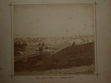
Photograph, BEAUCHAMP PHOTO 104 STURT STREET, BALLARAT, FROM ANGUS STREET HILL, LOOKING SOUTH, 1879
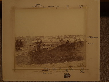
PHOTOGRAPH OF TOWNSHIP OF CLUNES ABOUT 1875. LOOKING SOUTH. WOODEN BRIDGE IN FOREGROUND, 1 SEPIA PHOTOGRAPH MOUNTED ON CARDBOARD .2 SEPIA PHOTOGRAPH MOUNTED EDGES REMOVED .3 BLACK AND WHITE PHOTO PRINT .4 BLACK AND WHITE PHOTO PRINT .5 PHOTOCOPY OF PHOTOGRAPHFROM ANGUS STREET HILL LOOKING SOUTHphotographs, clunes township and mining and footy oval -
 Clunes Museum
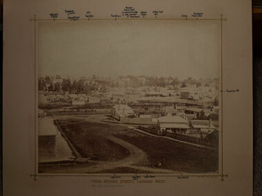
Photograph, BEAUCHAMP PHOTO 104 STURT STREET, BALLARAT, CIRCA 1870
PHOTOGRAPH OF CLUNES TOWNSHIP LOOKING WEST TAKEN FROM MRS.GREENWOODS HOME IN GEORGE STREET, CLUNES. BUILDINGS SHOWN INCLUDE JAMES MOLONEY AND CRITERION HOUSE. .1 SEPIA PHOTOGRAPH MOUNTED WITH POINTS OF INTEREST NOTED AROUND THE BORDER OF THE PHOTOGRAPH .2 LARGER SEPIA PHOTOGRAPH MOUNTEDFROM GEORGE STREET, LOOKING WESTlocal history, photography, clunes township -
 Clunes Museum
Photograph - PHOTOGRAPH CLUNES, BEAUCHAMP PHOTO, BALLARAT, C 1881
SEPIA PHOTOGRAPH OF CLUNES TOWNSHIP, TAKEN FROM ANGUS STREET HILL, LOOKING SOUTH; BUILDINGS INCLUDE WESLEY CHURCH, TOWN HALL, CATHOLIC CHURCH, C. OF E. CHURCH; CLUB HOTEL AND BANKS IN FRASER STREET; LIBRARY, FIRE BRIGADE BELL TOWER -FAR RIGHT.photographs, clunes township -
 Lakes Entrance Regional Historical Society (operating as Lakes Entrance History Centre & Museum)
Photograph, Bulmer H D, 1940c
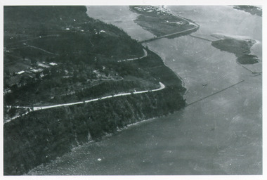
Black and white photograph of aerial view of Kalimna Heights, showing scattered buildings, Princes Highway around side of cliff, western end of township, North Arm bridge, footbridge to Bullock Island, and rock groynes. Track to lookout and signal beacon visible. Lakes Entrance Victoriaboats and boating, jetties, waterways, vegetation -
 Lakes Entrance Regional Historical Society (operating as Lakes Entrance History Centre & Museum)
Postcard, 1905c
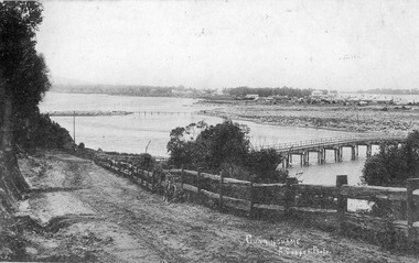
Also Black and white copy 12.5x20.5 Good condition P01146.1Black and white postcard of Cunninghame township, mud flats, North Arm Bridge, wooden bridge to mud island in North Arm, post and rail fence, beside main road. Road appears to have a sand surface. Bicycle leaning against fence. Lakes Entrance Victoriabridges, fences, topography, roads and streets -
 Linton and District Historical Society Inc
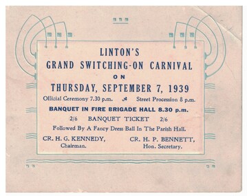
Card - Banquet Ticket, Linton's Grand Switching-On Carnival, 1939
Card with decoration of blue abstract electric lines on pale blue background. White square in centre of card with dark blue printing. Ticket is printed with details of an official ceremony, street procession, a banquet and a fancy dress ball to celebrate the connection and switching on of electricity to the township of Linton in 1939. Text: LINTON'S / GRAND SWITCHING-ON CARNIVAL / ON / THURSDAY, SEPTEMBER 7, 1939 / Official Ceremony 7.30 p.m. Street Procession 8 p.m. / BANQUET IN FIRE BRIGADE HALL 8.30 p.m.electricity, celebrations -
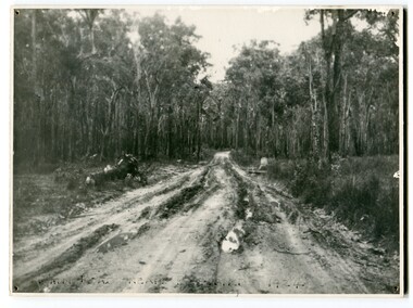 Orbost & District Historical Society
black and white photograph, 1924
This photograph shows the main road near Bellbird, East Gippsland, in 1924. This road would have been the Princes Highway, a main thoroughfare through to New South Wales. Bellbird Creek is a small rural location between Orbost and Cann River. There was no township at Cabbage Tree at this time. The Cabbage Tree Creek township was established to support the booming timber industry of the mid 20th century. Five timber mills worked full time supporting the families that were drawn to the area's wealth of natural resources. Nestled on the banks of the Cabbage Tree Creek, the township was built by those mills to house their workers. Today although the timber mills have disappeared, some of the buildings still remain. Little now remains to remind of the saw-milling history apart from photographs and some relics - a boiler and a brick furnace. There was also a thriving agricultural community farming dairy, beef, seed beans and fresh peas and beans that were sent to the Victoria Market in Melbourne. Dairy farming still plays an essential role in the township. this is a pictorial record of the Princes Highway, the main road from East Gippsland to the New South Wales border.A large black / white photograph of a very wet and boggy bush road.on front - "Main Rd near Bellbird 1924"road princes-highway bellbird-creek-1924 -
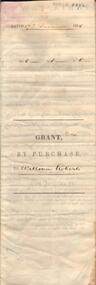 Bendigo Historical Society Inc.
Document - JOHANSON COLLECTION: GRANT BY PURCHASE WILLIAM ROBERTS
Legal document. On front: Dated 17th December 1855. Ac1 R1 P 1. ( acres, roods, perches ) Grant by purchase to William Roberts. In pencil Allot 7 of Sec 12. Inside: 'Victoria - Township Lot. Grantee W. Roberts. Document details purchase of land by above William Roberts of Heathcote, for the sum of two pounds, 12 shillings. Allotment 7, section 12, Township of Heathcote. Land sold as Lot 14. Dated 30 July 1855. Signed by C.W. Hotham ( Sir Charles Hotham ) Property is now 42 Beauchamp Street, Heathcote ( Landata research, 28.3.2017, https://www.landata.vic.gov.au/tpc_confirm_map.aspx?pfi=45257085 )heathcote, land sale, william roberts -
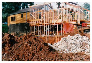 Marysville & District Historical Society
Photograph (Item) - Colour photograph, Unknown
A colour photograph taken during the construction of Arbor Green Cottage in Marysville. This cottage, along with most of the buildings in the township, was destroyed in the 2009 Black Saturday bushfires.A colour photograph taken during the construction of Arbor Green Cottage in Marysville.1 Falls Rd M'sville./ The future ahead./ The Arbor Green Galleries/ 3 Levels.marysville, victoria, australia, photograph, accommodation, arbor green cottage, 2009 black saturday bushfires -
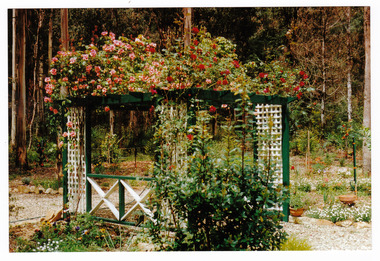
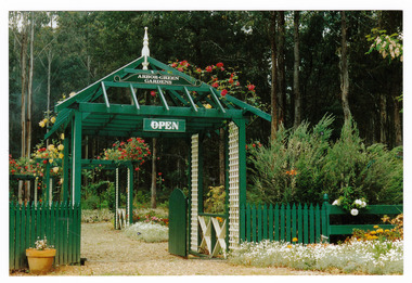 Marysville & District Historical Society
Photograph (Item) - Colour photograph, 1992
A colour photograph of the garden entrance and bridge at Arbor Green Gardens in Marysville. This cottage, along with most of the buildings in the township, was destroyed in the 2009 Black Saturday bushfires.A colour photograph of the garden entrance and bridge at Arbor Green Gardens in Marysville.Garden Entrance & bridge./ Arbor Green Galleries/ 1 Falls Rd. M'sville./ Spring 1992marysville, victoria, australia, photograph, accommodation, arbor green cottage, 2009 black saturday bushfires -
 Marysville & District Historical Society
Photograph (Item) - Colour photograph, Unknown
A colour photograph of the front facade and garden of Arbor Green Galleries in Marysville. This cottage, along with most of the buildings in the township, was destroyed in the 2009 Black Saturday bushfires.A colour photograph of the front facade and garden of Arbor Green Galleries in Marysville.1 Falls Rd M'sville./ Arbor Green Galleries & Cottage.marysville, victoria, australia, photograph, accommodation, arbor green cottage, 2009 black saturday bushfires -
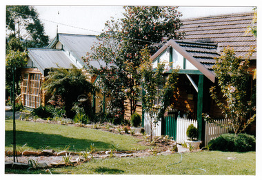
 Marysville & District Historical Society
Photograph (Item) - Colour photograph, 1992
A colour photograph of the front pergola at the entrance to Arbor Green Galleries in Marysville. This cottage, along with most of the buildings in the township, was destroyed in the 2009 Black Saturday bushfires.A colour photograph of the front pergola at the entrance to Arbor Green Galleries in Marysville.1 Falls Rd M'sville./ Arbor Green Galleries & Cottage.marysville, victoria, australia, photograph, accommodation, arbor green cottage, 2009 black saturday bushfires -
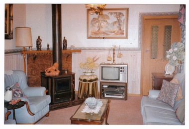 Marysville & District Historical Society
Photograph (Item) - Colour photograph, Unknown
A colour photograph of the sitting room in the cottage at Arbor Green Galleries and Cottage. This cottage, along with most of the buildings in the township, was destroyed in the 2009 Black Saturday bushfires.A colour photograph of the sitting room in the cottage at Arbor Green Galleries and Cottage.1 Falls Rd. M'sville./ Cottage Sitting Room.marysville, victoria, australia, photograph, accommodation, arbor green cottage, 2009 black saturday bushfires -
 Marysville & District Historical Society
Photograph (Item) - Colour photograph, Unknown
A colour photograph of one of the cottages at Amber View Cottages in Marysville. These cottages, along with most of the buildings in the township, were destroyed in the 2009 Black Saturday bushfires.A colour photograph of one of the cottages at Amber View Cottages in Marysville.amber view cottages, marysville, victoria, australia, accommodation, photograph, 2009 black saturday bushfires -
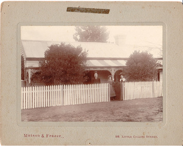 Hume City Civic Collection
Photograph, c1907
Members of the Fanning family standing outside their house 'Sunnyside', in Loemans Road, Bulla. The Fannings were one of the early European families to settle in the Bulla township. A black and white mounted photograph of the Fanning family in front of a cottage with a picket fence.Printed on face: Matson and Frazer / 264 Little Collins Street Handwritten on back: Eric Boardmanmatson and frazer, photographers, eric boardman collection, fanning family, george evans collection -
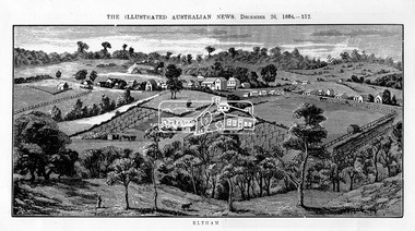 Eltham District Historical Society Inc
Photograph, Samuel Calvert, Eltham, The Illustrated Australian News, December 26, 1884, p212, 1884
A description in the newspaper near the illustration (page 210) reads as follows: "Eltham is a pretty little township on the Yarra Flats road, about 14 miles east north east of Melbourne, from which place there is communication by way of Heidelberg. It has a population of nearly 400 inhabitants, but in addition it is the centre of a large district extending over about 203 square miles, having a population of 2344. The land in the district is mostly used for grazing purposes, although as a rule the small farms grow a good deal of wheat, oats and other agricultural produce. A large quantity of fruit, especially raspberries and strawberries, is also produced, the rich alluvial flats along the creek upon which the township is situated being very well adapted for that purpose. Gold has also been found in the vicinity of the township, but not in remunerative quantities". This photo forms part of a collection of photographs gathered by the Shire of Eltham for their centenary project book,"Pioneers and Painters: 100 years of the Shire of Eltham" by Alan Marshall (1971). The collection of over 500 images is held in partnership between Eltham District Historical Society and Yarra Plenty Regional Library (Eltham Library) and is now formally known as 'The Shire of Eltham Pioneers Photograph Collection.' It is significant in being the first community sourced collection representing the places and people of the Shire's first one hundred years.Digital imageshire of eltham pioneers photograph collection, eltham, illustrated australian news -
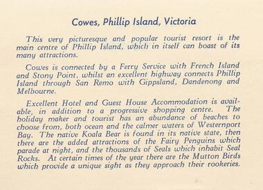 Phillip Island and District Historical Society Inc.
Photograph Folder, approx 1940's - 1950's
Coloured Souvenir folder of 12 postcards donated by M Arnell.Souvenir Colour Folder of 12 colour postcards of Cowes and Phillip Island. Photographs Include: Cowes Beach, Cowes Pier, Koalas, Cowes Township, The Nobbies, Summerland Surf Beach, Suspension Bridge, Thompson Avenue, Cowes, Penguin Parade, Seal Rocks, The Isle of Wight Hotel and The Blowhole.Front cover: A Souvenir of Picturesque Cowes. A Special selection of Scene in Full Colour.phillip island, cowes phillip isand, the isle of wight hotel cowes phillip island, the blowhole phillip island, penguins, koalas, seals, m arnell -
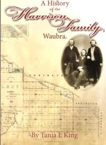 Learmonth and District Historical Society Inc.
Book, Tania.L.King. et al, A History of the Harrison Family,Waubra,by Tania.L.King, october 2012
This book gives the history of the Harrison Family of Waubra - celebrating 160 years in Australia from 1852-2012.The Harrison family came originaly from Catterick and later Langthorne,North Yorkshire.England.Recording the Family Tree of the Harrison Family of Waubra,Victoria.Cover of book is Beige in colour,with the title and authors name in maroon.On the right under the title is a photo of James Harrison with his two sons William and Christopher .The bottom of the cover shows the title plan of Ercildoun,sheet 2,courtsey State of Victoria.The back cover photograph is of Waubra township.A History of the Harrison Family,Waubra.by Tania.L.King.harrison family 1852 - 2012, waubra victoria, tania l king, catterick north yorkshire england, -
Bendigo Historical Society Inc.
Map - BAMAWM : COUNTY OF BENDIGO, November 1954
Map. Bamawm, County of Bendigo. Sheet 2, Pannoobamawm, Diggorra. Elmore to Cohuna Railway Line. Township of Lockington. By authority W.M. Houston, Government Printer.Drawn and reproduced at the Department of Lands and Survey, Melbourne. November 1954. Price 5/- per sheet. (number 52 in map cupboard 1)W.M. Houston, Government Printermap, bendigo, bamawm