Showing 1145 items
matching waterways
-
 Lakes Entrance Regional Historical Society (operating as Lakes Entrance History Centre & Museum)
Postcard, 1920c
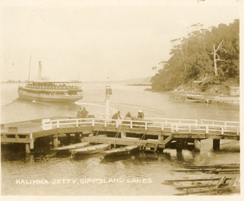
... Waterways ...also Black and white copy 10 x 12|also Sepia toned copy 10 x 15Sepia toned small format postcard of the steamer Gippsland leaving Kalimna Jetty, Gippsland Lakes Victoria, also showing boat ramps beside jetty, three rowing boats moored at lower landing, persons pushing trolly along jetty, Navigation light on jetty, rustic jetty and small boat in background. Lakes Entrance VictoriaKalimna Jetty Gippsland Lakesjetties, waterways, topography -
 Lakes Entrance Regional Historical Society (operating as Lakes Entrance History Centre & Museum)
Photograph, Valentine Series, 1915c
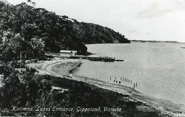
... Waterways ...Black and white photograph of the lake shore at Kalimna, showing Kalimna jetty and storage shed, low sandy shore in foreground contrasting with steep cliffs beyond jetty. Indistinct distant view of New Works area at southern shore of Cunninghame Arm. Lakes Entrance VictoriaKalimna Lakes Entrance Gippsland Victoriajetties, waterways, navigation -
 Lakes Entrance Regional Historical Society (operating as Lakes Entrance History Centre & Museum)
Photograph, 1930c
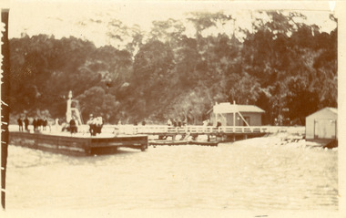
... Waterways ...Black and white photograph of Kalimna Jetty. It shows a substantial jetty and landing, storage shed and boat shed, navigation light on end of jetty, many people on jetty, perhaps waiting for arrival of passenger steamer, in background steep cliffs bordering shoreline. Lakes Entrance Victoriawaterways, topography, township -
 Lakes Entrance Regional Historical Society (operating as Lakes Entrance History Centre & Museum)
Photograph, Davies, Judy, 2005c
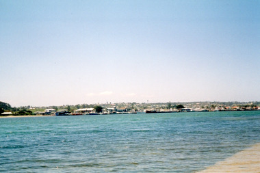
... Waterways ...Colour photograph of the township viewed across the Cunninghame Arm from the New Works area. Lakes Entrance Victoriawaterways, township, public works -
 Lakes Entrance Regional Historical Society (operating as Lakes Entrance History Centre & Museum)
Photograph, 1920c
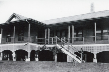
... Waterways ...Built by John Herbert Syme in about 1911 to 1912.Black and white photograph of Kawar the home built on Fraser Island, Gippsland Lakes. It shows a substantial weatherboard dwelling, built about two metres above ground level, corrugated iron roof, veranda all around, steps leading to veranda. Man in top hat at bottom of steps. Lakes Entrance Victoriawaterways, islands, ocean -
 Lakes Entrance Regional Historical Society (operating as Lakes Entrance History Centre & Museum)
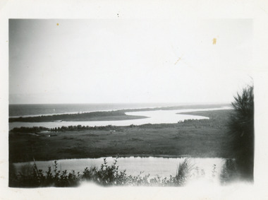
Photograph, 1950c
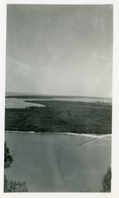
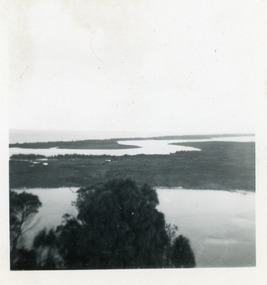
... Waterways ...Black and white photograph of view from Kalimna across Rigby Island to back lakes near Lakes Entrance, Victoriaislands, waterways, topography -
 Lakes Entrance Regional Historical Society (operating as Lakes Entrance History Centre & Museum)
Photograph, 1950c
... Waterways ...Two other copies 6 x 9 (one - slightly different view)Small format photograph of view from Kalimna across Rigby Island to back lakes near Lakes Entrance, Victoriaislands, waterways, topography -
 Lakes Entrance Regional Historical Society (operating as Lakes Entrance History Centre & Museum)
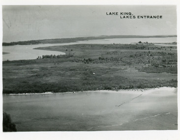
Postcard, Bulmer H D, 1950c
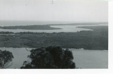
... Waterways ...Two other copies same sizeBlack and white small format postcard showing part of Rigby Island, Reeves Channel, Hopetoun Channel, The Barrier, on Gippsland Lakes, Victoria, showing foreground bushes, and Bass Strait in distance.Lake King Lakes Entranceislands, waterways, topography -
 Lakes Entrance Regional Historical Society (operating as Lakes Entrance History Centre & Museum)
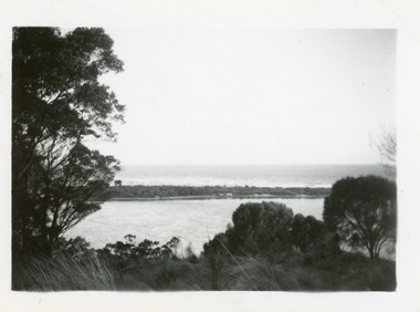
Photograph, 1950c
... Waterways ...Black and white photograph showing sand dunes and Hopetoun Channel, Lakes Entrance, Victoria. Sand dunes near entrance Western Pier, hidden by trees. Schnapper Cottage just visible on shore. Bass Strait beyond dunes, trees and shrubbery in foreground Jemmys Point. Lakes Entrance Victoriaislands, topography, waterways -
 Lakes Entrance Regional Historical Society (operating as Lakes Entrance History Centre & Museum)
Photograph, 1990c
... Waterways ...This is the before paired photograph used in the 150 year, Lakes Entrance 1858-2008 display.|The after paired photograph number is 01666.1|Also one 12 x 16 framed photograph used in room display.Colour photograph showing sand dunes, Snake Island and rock groynes, Lakes Entrance, Victoria.waterways, islands, vegetation -
 Lakes Entrance Regional Historical Society (operating as Lakes Entrance History Centre & Museum)
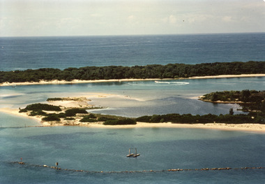
Photograph, 2008
... Waterways ...Date made August 2008Colour photograph showing eastern end of Rigby Island, Snake Island, Reeves Channel in the foreground, Hopetoun Channel with a house and jetty with boats moored. Ocean in the background. Lakes Entrance Victoriawaterways, islands, vegetation -
 Lakes Entrance Regional Historical Society (operating as Lakes Entrance History Centre & Museum)
Postcard, Bulmer and Segerberg, 1915c
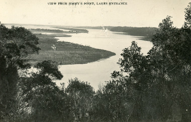
... Waterways ...Black and white postcard of the Gippsland lakes, taken from Jemmys Point. It shows Rigby Island, Fraser Island and Flannagan Island, Reeves Channel. Natural vegetation in foreground. Lakes Entrance VictoriaView from Jimmy's Point Lakes Entranceislands, waterways, topography -
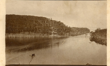
 Lakes Entrance Regional Historical Society (operating as Lakes Entrance History Centre & Museum)
Photograph, 1910c
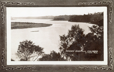
... Waterways ...Also another copy print 8 x 13, both printed as though framedBlack and white photograph of Reeves Channel, Gippsland Lakes. It shows Rigby Island opposite the steep cliffs of mainland shore. Small island off Rigby was known as the Doughboy. Taken from Jemmys Point, natural vegetation in foreground. Lakes Entrance VictoriaReeves River from Kalimnaislands, waterways, topography -
 Lakes Entrance Regional Historical Society (operating as Lakes Entrance History Centre & Museum)
Photograph, 1915c
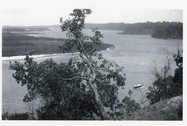
... Waterways ...Original in possession of descendant of Arthur Seagrove, teacher at Johnsonville School 1920c.Black and white photograph of Reeves Channel, Gippsland Lakes, showing a launch in the Narrows below Jemmys Point, Rigby Island and a distant view of Fraser Island and Flannagan Island opposite the steep cliffs of the mainland shore. Lakes Entrance Victoria'To Rit with love from Arthur' on backislands, waterways, topography -
 Lakes Entrance Regional Historical Society (operating as Lakes Entrance History Centre & Museum)
Photograph, Hammarstrom Ian, 1987 c
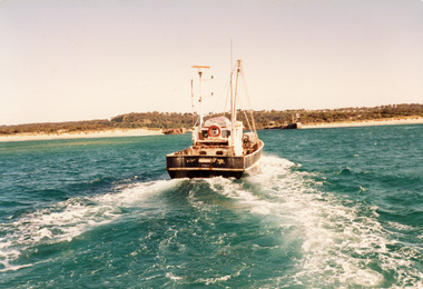
... Waterways ...Colour photograph of the fishing boat Southern Hope approaching the entrance channel, from the ocean, shows sandy beach each side of entrance piers and shallow water over the outer bar, sea calm. Lakes Entrance Victoriaships and shipping, waterways, fishing industry -
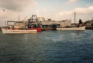 Lakes Entrance Regional Historical Society (operating as Lakes Entrance History Centre & Museum)
Photograph, Hammarstrom Ian, 1986 c
... Waterways ...Colour photograph of three fishing boats at the fishing co-op jetties at Bullock Island, boats identified as Nadgec on left, Craig Min centre and Gaylar on right. Lakes Entrance Victoriaships and shipping, fishing industry, waterways -
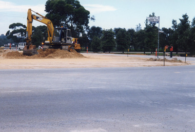
 Lakes Entrance Regional Historical Society (operating as Lakes Entrance History Centre & Museum)
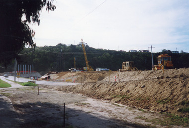
Photograph, Davies Judy, 1999
... Waterways ...Date made 10 April 1999Colour photograph of the construction of the road approaches and abutments for the new North Arm bridge, earthmoving machinery and crane on southern approach looking towards northern abutment. Lakes Entrance Victoriabridges, waterways, machinery -
 Lakes Entrance Regional Historical Society (operating as Lakes Entrance History Centre & Museum)
Photograph, 1999
... Waterways ...Date made June 1999Colour photograph of the new North Arm Bridge, under construction, taken on the bridge. Lakes Entrance Victoriabridges, waterways, boats and boating -
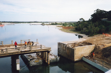 Lakes Entrance Regional Historical Society (operating as Lakes Entrance History Centre & Museum)
Photograph, 2000
... Waterways ...Date made May 2000Colour photograph showing the activity during the deconstruction of the old North Arm bridge showing cranes lifting handrails, circular saw cutting concrete bridge decking, and top of piers removed. Scene indicates how the bridge was constructed in 1917. Lakes Entrance Victoriabridges, waterways, boats and boating -
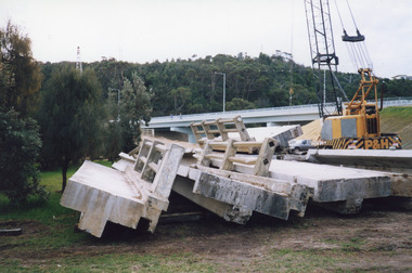 Lakes Entrance Regional Historical Society (operating as Lakes Entrance History Centre & Museum)
Photograph, 2000
... Waterways ...Date made May 2000.Colour photograph of stacked sections of the old concrete North Arm bridge, Lakes Entrance, Victoria.bridges, waterways, construction -
 Lakes Entrance Regional Historical Society (operating as Lakes Entrance History Centre & Museum)
Photograph, 1999
... Waterways ...Date made January 1999 - June 2000Colour photograph of North Arm bridge under construction. Lakes Entrance Victoriabridges, waterways, public works -
 Lakes Entrance Regional Historical Society (operating as Lakes Entrance History Centre & Museum)
Photograph, 1919
... Waterways ...Three identical black and white copies, 8 x 10 cmSepia photograph showing Lake Bunga near Lakes Entrance, with tramline across lake with one panel missing. Lake full and clean. Hard to see whether the entrance is open or closed. (After 1919) Lake Bunga VictoriaLake Bunga Vic (on reverse)transport, waterways, room display -
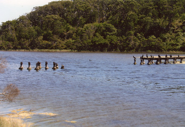 Lakes Entrance Regional Historical Society (operating as Lakes Entrance History Centre & Museum)
Photograph, Davies Judy, 2008
... Waterways ...This is after paired photograph used in the 150 year, Lakes Entrance 1858-2008 display.|The before paired photograph number 02218|Also one 12 x 16 framed photograph used in room display.Colour photograph showing Lake Bunga near Lakes Entrance with the remains of tramline crossing, birds sitting on the remains. Lake Bunga Victoriabridges, waterways, transport -
 Lakes Entrance Regional Historical Society (operating as Lakes Entrance History Centre & Museum)
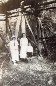
Postcard, 1920
... Waterways ...Small format black and white postcard showing a distant view of tramway bridge at Lakes Bunga, Victoria. Two women in foreground, image taken from Bunga Haven guesthouse.bridges, timber industry, waterways -
 Lakes Entrance Regional Historical Society (operating as Lakes Entrance History Centre & Museum)
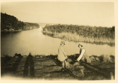
Photograph, Jemmeson, Edie, 1925
... Waterways ...Copied from E Jemmeson albumBlack and white photograph of two women and young boy under the tramway bridge showing piers and supports of unmilled natural timbers. Lakes Bunga Victoriatopography, waterways, bridges -
 Lakes Entrance Regional Historical Society (operating as Lakes Entrance History Centre & Museum)
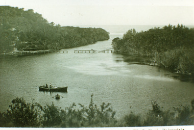
Photograph, Vogt, W S, 1920
... Waterways ...Also one enlarged copy 20.5 x 28.5 cm|Also one copy 12 x 17|Also giant colour postcardBlack and white photograph showing view of Lakes Bunga, near Lakes Entrance. Tramline across lake shows beginnings of disrepair, one panel gone, another panel broken, two row boats on lake, larger one contains two adults and four children, smaller row boat has one small child. Entrance appears to be closed, thick vegetation around lake. Lake Bunga VictoriaLake Bunga (Northrope's), W S Vogt, Bairnsdalewaterways, topography, bridges -
 Lakes Entrance Regional Historical Society (operating as Lakes Entrance History Centre & Museum)
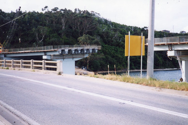
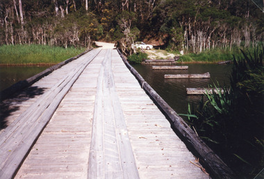
Photograph, 1998
... Waterways ...Also photograph of bridge from different angleColour photograph of the crossing at Toorloo Arm on the previous main road from Lakes Entrance to Nowa Nowa known as Burnt Bridge. Lakes Entrance Victoriabridges, waterways, vegetation -
 Lakes Entrance Regional Historical Society (operating as Lakes Entrance History Centre & Museum)
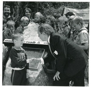
Photograph, 1991
... Waterways ...This photo appeared in the L P Newspaper 13 November 1991Black and white photograph taken at the celebration to open the new concrete Princes Highway bridge over Toorloo Arm. Plaque unveiled by Minister for Land Transport, Bob Brown, seen greeting the youngest member of the community, Toorloo Arm Sea Scouts in attendance. Toorloo Arm Victoriabridges, waterways, animals