Showing 25214 items
matching north
-
 Queen Victoria Women's Centre
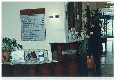
Photograph, 10 July 1998
Colour photograph. Reception area on ground floor southern entrance. Desk has an assortment of flyers and brochures. Behind reception area is a building guide. Unidentified woman appears to the right o frame in front of the reception desk. Taken from the entrance facing northentrances, historic buildings, cultural structures and establishments -
 Lakes Entrance Historical Society
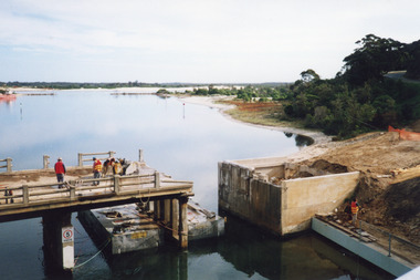
Photograph - Old North Arm Bridge, 2000
Date made May 2000Colour photograph showing the activity during the deconstruction of the old North Arm bridge showing cranes lifting handrails, circular saw cutting concrete bridge decking, and top of piers removed. Scene indicates how the bridge was constructed in 1917. Lakes Entrance Victoriabridges, waterways, demolition -
 Lakes Entrance Historical Society
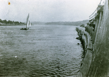
Photograph - The Entrance, 1922
Black and white photograph showing entrance and piers, viewed from ocean end of pier looking north towards Kalimna, small sailing boat in entrance inside of Eastern Pier, on right amongst the timber piers is a man leaning out. Lakes Entrance Victoria waterways, piers, boats and boating -
 Lakes Entrance Historical Society
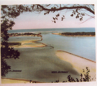
Photograph - The Entrance, 1945c
Other copiesHand tinted colour photograph of the man-made entrance from Bass Strait to the Gippsland lakes, taken from Jemmys Point. It also shows the rock groynes at the western end of Bullock Island, and at the entrances to Cunninghame Arm and the North Arm. Lakes Entrance VictoriaThe Entrance, Lakes Entranceislands, waterways, boats and boating -
 Lakes Entrance Historical Society
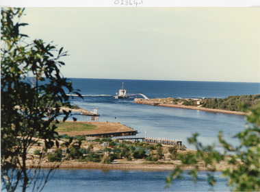
Photograph - The Entrance, Tambo Shire, 1990
Colour photograph showing the entrance to the lakes from Bass Strait, dredge April Hamer working on the bar. Western spit on right, eastern spit hidden behind bush, Bullock Island on left centre, mouth of North Arm in foreground, Lakes Entrance, Victoria.waterways, islands, township -
 Bendigo Historical Society Inc.
Postcard - Alice McGregor Postcard Collection, 1900 - 1920
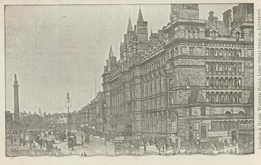
Alice McGREGOR Born: 1908; unknown parents. Possibly adopted by the Salter family? Electoral Roll 1936: Highland Terrace Kangaroo Flat. Alice Mary Salter and William Robert Salter living together; presumed to be sister and brother. William Robert Salter was killed in a MVA in Bendigo in 1937 aged 26. In Victoria in 1938, Alice Mary Salter married James Thomas McGregor (born Victoria 1917, died Victoria 1983, buried Fawkner Cemetery) Lived: 1968; 22 Wade Street Golden Square Alice McGregor Died: 1999 aged 91 at Anne Caudle Centre, Bendigo Buried: Kangaroo Flat Cemetery See additional research. Postcard Album of Alice McGregor contained 86 post cards.Postcard Album of Alice McGregor containing 86 postcards. See 1400 B&W photo of the London & North Western Hotel, Lime Street Station, Liverpool. A multi-story building overlooking a statue atop a column. Horse drawn vehicles and pedestrians in the street. Addressee - Miss Kelly, Norwood, Wills St, Bendigo, Australia Sender - M.I. Grendell (?) Dated 25 5.06, Liverpool postcard, collector, alice mcgregor -
 Bendigo Historical Society Inc.
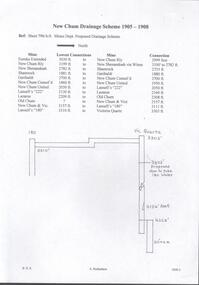
Document - DRAINAGE PROBLEMS - DRAINAGE 1905 - 1908
Two handwritten pages naming the mine, the lowest connection and connection to the next mine for the proposed drainage scheme. The second page lists the mines, from South to North, the projected distances in feet and to the nearest yard. Document from Albert Richardson Collection of mining history.document, gold, drainage problems, new chum drainage scheme, drainage 1905 - 1908, mines dept sheet 796/a/6 proposed drainage scheme, south belle vue, eureka ext'd, new chum railway, new shenandoah, shamrock, garibaldi, new chum consol'd, new chum united, lansell's 222, lazarus, old chum ?, new chum & vic, lansell's 180, victoria quartz -
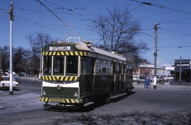
 Melbourne Tram Museum
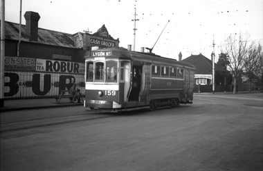
Negative, Wal Jack, 23/07/1944 12:00:00 AM
Black and white negative, by Wal Jack, of S 159 in Barkly St, North Fitzroy, with intersection of St Georges Road. Tram has the destination of Lygon St. Photo dated 23-7-1944 in the Wal Jack album along with details of the location and the tramcar.trams, tramways, s class, barkly st, st georges road, tram 159 -
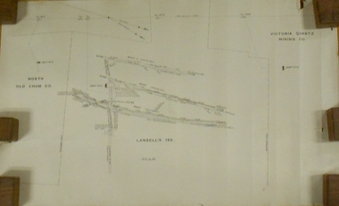 Bendigo Historical Society Inc.
Plan - MARKS COLLECTION: LANSELL'S 180 PLAN, LEVELS 18, 19 AND 20
Plan of underground section of Lansell's 180 mine, levels 18, 19 and 20. On RH side of map Victoria Quartz Mining company claim marked, on LH side North Old Chum Co. 'West or hanging wall' marked above each level.bendigo, mining, lansell's little 180 mine -
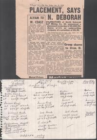 Bendigo Historical Society Inc.
Newspaper - THE NORTH DEBORAH GOLD MINE CO - NEWSPAPER ARTICLE ON THE THE NORTH DEBORAH GOLD MINE CO
Newspaper article referring to the Directors of North Deborah Mining Co. NL announcing a placement of 50,000 25c shares with an underwriting company at a premium of $5.35. Newspaper cutting from The Sun, Friday, Jan 9, 1970. Attached to it is a handwritten page with various measurements and depths.newspaper, sun news -pictorial, the north deborah gold mine co, the north deborah gold mine co, newspaper article on the the north deborah gold mine co, melbourne stock exchange, ralph w. king & yuill, mr r d knowles -
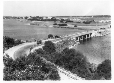 Lakes Entrance Historical Society
Photograph - North Arm bridge Lakes Entrance Victoria, 1935c
Black and white photograph of view of concrete North Arm Bridge, showing highway to town, Cunninghame Arm, sand hummocks, vegetation, touring car approaching bridge, and three cars parked at town end of bridge, electricity and telegraph poles. Lakes Entrance Victoriatownship, vegetation, transport, bridges -
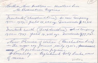 Bendigo Historical Society Inc.
Document - GOLD PRODUCTION - NOTES ON GOLD PRODUCTION
Handwritten notes by Albert Richardson on gold production, year and dividends of North or New Hustlers (Hustlers Line), Ironbark (Sheepshead Line), Ironbark South (Sheepshead Line), New Prince of Wales (Carshalton Line). And locality of the New Prince of Wales. Albert Richardson CollectionAlbert Richardsongold, goldfields, victoria, gold production, notes on gold production, north or new hustlers, hustlers line, ironbark, sheepshead line, ironbark south, new prince of wales, carshalton line, eaglehawk golf links -
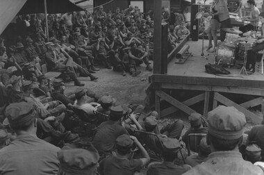 National Vietnam Veterans Museum (NVVM)
Photograph, Gibbons, Denis, Digby Richards
Denis Gibbons (1937 – 2011) Trained with the Australian Army, before travelling to Vietnam in January 1966, Denis stayed with the 1st Australian Task Force in Nui Dat working as a photographer. For almost five years Gibbons toured with nine Australian infantry battalions, posting compelling war images from within many combat zones before being flown out in late November 1970 after sustaining injuries. The images held within the National Vietnam Veterans Museum make up the Gibbons Collection. A black and white photograph of Digby Richards and his show entertain US troops at a Fire Support Base North East of Danang in Northern South Vietnam. While Australian Concert Parties entertained, where practicable, US troops, American USO did not reciprocate.photograhp, entertainment, digby richards, us troops, danang, gibbons collection catalogue, digger, fire support base, australian concert parties, denis gibbons -
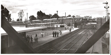 Bendigo Historical Society Inc.
Photograph - BASIL MILLER COLLECTION: TRAMS - CAVALCADE OF TRAMS MITCHELL STREET, BENDIGO, BENDIGO RAILWAY STATION, 1960's ?
BHS CollectionBlack and white photo. 5 trams heading east along Mitchell Street, photographed crossing railways bridge to North of Bendigo Railway Station. Photo taken from railway station. People waiting for train on platform. Railways lines prominent in front of photo.basil miller, bendigo tramways, bendigo rail station, mitchell street rail bridge -
 Greensborough Historical Society
Book, Nillumbik Shire Council, 1997 Community Guide Nillumbik, 1997_
Guide to services provided by Nillumbik Shire Council. Nillumbik Shire is located 25 kilometres north-east of Melbourne and the southern boundary is the Yarra River. The south of Nillumbik is predominantly urban, with commercial centres at Eltham and Diamond Creek. The north of the municipality includes significant natural features like Kinglake National Park and Sugarloaf ReservoirAnnual guide to services in Nillumbik. 64 pages. Cover is pale yellow with colour drawings. nillumbik shire council, handbooks -
 Greensborough Historical Society
Book, Nillumbik Shire Council, 1998 Community Guide Nillumbik, 1998_
Guide to services provided by Nillumbik Shire Council. Nillumbik Shire is located 25 kilometres north-east of Melbourne and the southern boundary is the Yarra River. The south of Nillumbik is predominantly urban, with commercial centres at Eltham and Diamond Creek. The north of the municipality includes significant natural features like Kinglake National Park and Sugarloaf ReservoirAnnual guide to services in Nillumbik 72 pages. Cover has white background and some 3-D artwork.nillumbik shire council, handbooks -
 Greensborough Historical Society
Book, Nillumbik Shire Council, 1999 Community Guide Nillumbik, 1999_
Guide to services provided by Nillumbik Shire Council. Nillumbik Shire is located 25 kilometres north-east of Melbourne and the southern boundary is the Yarra River. The south of Nillumbik is predominantly urban, with commercial centres at Eltham and Diamond Creek. The north of the municipality includes significant natural features like Kinglake National Park and Sugarloaf ReservoirAnnual guide to services in Nillumbik76 pages, illus. Cover has photographs of local people and title in white on orange background.nillumbik shire council, handbooks -
 Greensborough Historical Society
Book, Nillumbik Shire Council, Nillumbik Community Guide 2000/2001, 2000-2001
Guide to services provided by Nillumbik Shire Council. Nillumbik Shire is located 25 kilometres north-east of Melbourne and the southern boundary is the Yarra River. The south of Nillumbik is predominantly urban, with commercial centres at Eltham and Diamond Creek. The north of the municipality includes significant natural features like Kinglake National Park and Sugarloaf ReservoirAnnual guide to services in Nillumbik76 pages, black and white illustrations. Cover has a collage of local children with title in white on mid-blue background.nillumbik shire council, handbooks -
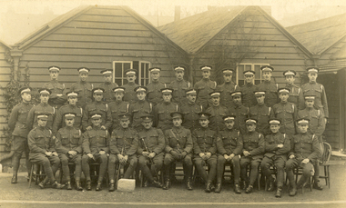 Federation University Historical Collection
Postcard, "A" Squad Cadets, St John's Wood Barracks, 1917
St John's Wood is a district of north-west London, in the City of Westminster, and at the north-west end of Regent's Park. The King's Troop, Royal Horse Artillery formerly resided at St John's Wood Barracks. The regiment moved to Woolwich on 6 February 2012; the barracks is to be demolished and developed as housing. (http://en.wikipedia.org/wiki/St_John's_Wood)A number of uniformed men pose for a photograph in front of a weatherboard building. The image is of the "A" Squad Cadets at St John's Wood Barracks, London.This card was purchased by an Australian soldier, probably Henry Smerdon Holmes, during World War One. Verso: "A" Squad Cadets. St John's Wood Barracks, London, 12th March 1917chatham family collection, chatham, world, war, world war one, world war 1, world war i, france, harry holmes, holmes, st john's wood -
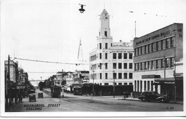 Ballarat Tramway Museum
Postcard, Valentine & Sons Publishing Co, "Moorabool Street Geelong", c1950
Postcard produced by the Valentine publishing company of Moorabool St looking north and the corner of Ryrie St. In the view is tram No. 17 and another tram further north. Note the safety zone sign. In the view is the T&G building, the Bank of NSW, with a sign "Service for the Sick". The rear of the card notes it is a genuine photograph. Photo c1950.Yields information about the view of Moorabool St at Ryrie St c1950.Black and white Postcard undivided back, unused. Card No. V24.tramways, trams, geelong, moorabool st, tram 17 -
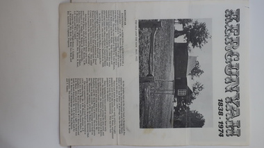 Kiewa Valley Historical Society
Leaflet - Kergunyah, Kergunyah 1838 - 1974, 1974
Kergunyah is a small town in the Kiewa Valley in north east Victoria. It is 10km south of Kiewa (town) and 23 km north of Dederang (town). it is farming country commencing in 1838, developing into a small community in 1974 with a School, Church, Post Office, Football Club, Young Farmer Club C.W.A. Netball Club, Card Club and Fire Brigade.Kergunyah is in the Kiewa Valley. Its history is important in the valley as it developed from a large pastoral run in 1838 into a small community supporting the local farming industry with essential organisations eg. school, fire brigade and social organisations eg. sporting teams, C.W.A.. Its history is significant as this leaflet has details of the organisations up to 1974 and this detail can be compared to organisations at Kergunyah today and can be compared to the history of other small rural communities. White stiff paper, folded to A4 size, with black and white photos on each of the 4 pages. Each page has detailed information under headings of community buildings and clubs in the small town. kergunyah; kiewa valley; small community; rural town; -
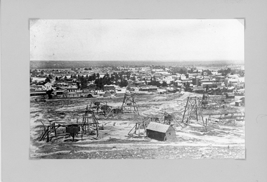 Stawell Historical Society Inc
Photograph, Panorama of Stawell from Big Hill with Whims, Poppet Heads & Leaning Shed c 1878
Scene from Big Hill. Market Building in Skene Street at left of Stawell Court House. Businesses at corner of Sloane and Patrick Streets visible. Agnew Drapers store and buildings in upper Main Street visible Shows Mining activity in foreground 1878. Whim in foreground is No7 North Scotchmans and Whim next to that No8 North ScotchmansBlack & White Photograph from Big Hill. Market building left of Court house . Photo shows mining activity in the foreground, Stawell in the background c 1878. refer. Original c 1880 folder (room 2) from Don Rickard & Geoff Oates.stawell, panorama, streetscape, mining -
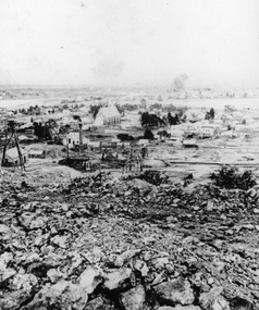 Stawell Historical Society Inc
Photograph, St Patrick's Church and surrounds from Big Hill with mining activity in foreground
St. Patrick’s Catholic Church and surrounding buildings 1880's. Poppet heads can be seen in the foreground and mining spoil around Big Hill. Behind the church is the Poppet Head of No4 North Scotchmans. The Poppet Head at the left of the photo is No1 & No2 North Scotchmans which joined with the Stawell Amalgamated Scotchmans Company in 1887. Early view of St Patrick's Catholic Church and surrounds from Big Hill. Mining works and spoil in the forground. stawell, panorama, mining -
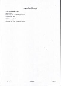 Bendigo Historical Society Inc.
Document - MINING REPORTS - KING OF PRUSSIA MINE
KING OF PRUSSIA MINE WHIPSTICK ROAD EAGLEHAWK NORTH, GREATER BENDIGO CITY Place ID 8444 Location WHIPSTICK ROAD EAGLEHAWK NORTH, GREATER BENDIGO CITY Municipality GREATER BENDIGO CITY Heritage Listing Victorian Heritage Inventory Level of significance Heritage Inventory Site Heritage Inventory (HI) Number H7724-0141Brief handwritten notes by Albert Richardson, with typed copy of same, on the King of Prussia Mine on the Lightning Hill Line. Notes give the depth, crushings, gold yield, commenced 1876 and closed 1877.gold, mining reports, mining reports, kinf of prussia mine, b m l production statistics -
 Ballarat Tramway Museum
Slide - Set of 6, Warren Doubleday, Ballarat - last day of the Lydiard St Nth to Sebastopol line, 19/9/1971
Photos taken on the last day of the SECV operated tram services in Ballarat 19/9/1971 1 - Tram 39 running out as Special at corner of Sturt and Drummond St North. Has the Mobil Service station and J A Malpass shop in the background. 2 - Tram 40 waiting at the railway gates. Has the Kennedy Murray Pty Ltd General Carrier office in the background and the railway goods shed. Photo taken from the signal box. 3 - Tram 42 in Lydiard St North with Reids Coffee Palace and the Provincial Hotel in the background. The street is very quiet. 4 - Tram 39 at the Lydiard St North terminus. 5 - Tram 40 at the Lydiard St North terminus. Note the shelter and the tram stop pole. 6 - Tram 40 using the Dawson St Crossover with St Patricks Cathedral behind.Yields information about the last day of SEC public operations in Ballarat.Set of 6 Kodachrome colour slides - cardboard mounts. Sixth one in a green card mount.Have the photographer's slide numbers written on them.trams, tramways, closure, tram 35, tram 34, tram 42, tram 40, lydiard st north, level crossing, dawson st -
 Warrnambool and District Historical Society Inc.
Map - Maps, Soldiers Settlement WW2, Circa 1950
The soldiers' settlement scheme operated after the first and second world wars in an effort to more closely settle the land and also give opportunities to returned soldiers. Crown land and other larger estates were acquired for the purpose. Most of these maps relate to the area north of Warrnambool where many of the subdivisions were parts of larger estates.These maps pertaining to the Soldiers' Settlement program, relate to an interesting part of Australian and local history. As such they have historic and social interest and significance.A collection of 25 paper maps which relate to to the soldiers settlement post World War 2. Some have details of the people allocated the land and some smaller maps have the printed details of the applicants requirements.Text is black on white paper which in some cases is quite aged. The maps are as follows: .1 Narrapumelap Estate ( Ripon & Hampden) .2 Narrapumelap Estate Part 2 (Villers & Ripon) .3 Narrapumelap Estate Part 3 ( Villiers & Ripon) .4 Burrumbeet Estate ( Ripon) .5 ' Berrambool' Estate 9 Hampden & Villiers) .6 ' Hopkins Hill' Estate Villiers 4011 acres .7 Caramut North No 2 Estate ( Villiers ) .8 ' Morpor' Estate ( Villiers) 4172 acres .9 ' Morgiana' Estate ( Normandy) 3453 acres .10 ' Chatsworth House' ( Villiers) 9341 Acres .11 ' East Elwood' Estate Villiers 2407 acres .12 Grey's Estate ( Mornington) 1151acres .13 ' Rowes Estate' ( Buln Buln Gippsland 733 acres .14 'Tarrone' Estate No 2 Part map .15 'Chaldon Meade' Estate (Bourke) Bulla 517 acres .16 ' Terranallum South' Estate Hampden 3757 acres .17 ' Brung Brungle' Estate Dundas 695 .18 ' Armidale ' Estate ( Dundas)2108 acres .19 ' Moyne Falls' Estate ( Villiers) 627 acres .20' Yulong' Estate 9 Lowan 6321 acres .21 Murray Valley Irrigation District 9 Moira)113 acres .22 Murray Valley Irrigation District 103 acres .23 ' Mount Fyans' Estate ( Hampden) .24 ' Barwidgee ' Estate ( Villiers) 4277 acres .25 'Pine Hills' Estate 2nd portion ( Lowan) 6190 acres narrapumelap, berrambool, hopkins hill, caramut north, morpor, chatsworth house, east elwood, terrinallum, moyne falls, tarrone, caramut soldiers settlers, burrumbeet, morgiana, grey's estate mornington, chaldon meade, brung brungle -
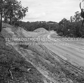 Eltham District Historical Society Inc
Negative - Photograph, J.A. McDonald, Heidelberg-Kinglake Road, Sep. 1959
Job 56M430 Contractor Hone Same deviation looking south from north end towards HurstbridgeRecord of various Shire of Eltham infrastructure works undertaken during the period of 1952-1962 involving bridge and road reconstruction projects, sometimes with Eltham Shire Council Project Reference numbers quoted. It was during this period that a number of significant improvements were made to roads and new bridges constructed within the shire that remain in place as of present day (2022). In many situations, the photos provide a tangible visible record of infrastructure that existed throughout the early days of the Shire. The album was put together by or under the direction of the Shire Engineer, J.A. McDonald.infrastructure, shire of eltham, bridge construction, 1959-09, heidelberg-kinglake road, road construction -
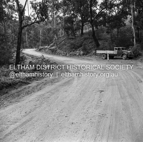 Eltham District Historical Society Inc
Negative - Photograph, J.A. McDonald, Heidelberg-Kinglake Road, Mar. 1960
Job 56M431 Curve improvement north of Yow Yow Creek March 1960 Contractor F.C. WoodRecord of various Shire of Eltham infrastructure works undertaken during the period of 1952-1962 involving bridge and road reconstruction projects, sometimes with Eltham Shire Council Project Reference numbers quoted. It was during this period that a number of significant improvements were made to roads and new bridges constructed within the shire that remain in place as of present day (2022). In many situations, the photos provide a tangible visible record of infrastructure that existed throughout the early days of the Shire. The album was put together by or under the direction of the Shire Engineer, J.A. McDonald.infrastructure, 1960-03, bridge construction, cherry tree road, heidelberg-kinglake road, road construction, shire of eltham -
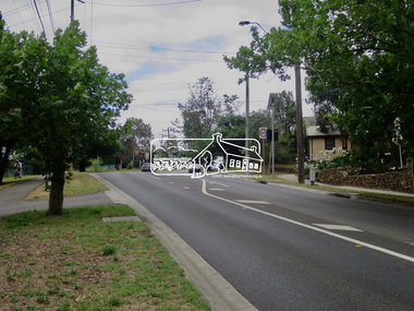 Eltham District Historical Society Inc
Photograph, Jim Connor, Avenue of Honour, Main Road, Eltham, 14 Jan 2017
Eltham Gateway, View looking north to intersection of Brougham Street from near 715 Main RoadTomorrow's history documented todayeltham, jim connor collection, main road, eltham gateway, avenue of honour -
 Eltham District Historical Society Inc
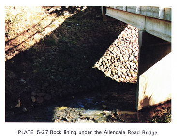
Work on paper (Sub-Item) - Photograph, Rock lining under the Allendale Road Bridge, 1976
Colour photograph of rock lining along the Diamond creek under the Allendale Road Bridge, Eltham Northrock lining, bridge, eltham north, diamond creek