Showing 13828 items
matching tasmanian-built
-
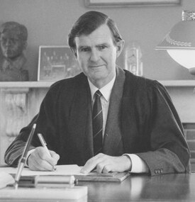 Mentone Grammar School
Principal (1988-2004) Neville J. Clark MC OAM
The untimely death of Principal Keith Jones paved the way for the appointment of decorated Vietnam veteran Neville Clark who valued the School’s character-building ethos and, whereas Jones saw academic results and sport as paramount, Clark believed these were only part of the education of a well-rounded individual. To this end he extended the function of the House system which now had a leading role in pastoral care, rather than just being for sporting purposes. The arts became more prominent and the Gregory Fish Library and a new swimming complex were built. (taken from '90 Years in the Making') -
 Ballarat Tramway Museum
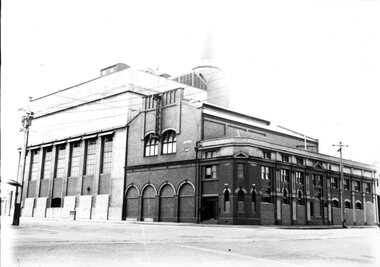
Photograph - Geelong power station, Melbourne Electric Supply Co. (MESCo), c1926
Photograph shows Geelong power station after completion. Power house building on the SW corner of Corio Tce. and Yarra Sts, Geelong, with new furnace room on the left, turret removed from the corner of the building, a third floor added on the Corio Tce. side but offices and concreted company name above where the trams entered the depot from the street not yet built. Date between 1924 and 1928 (based on photograph of Pengelly tramcar arriving and recently received, secondhand Melbourne tramcar). The ground floor offices facing Corio Tce. appear to be boarded up.Yields information about the Geelong Power station c1926Black and white print on paper.Plate number 1-8 in ink on back of photo.tramways, geelong, mesco, power station -
 Ballarat Tramway Museum
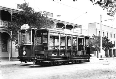
Photograph - Geelong Tramway "Summer Car"
"Summer Car" 11 outside Mac's Hotel in Corio Tce. To the right is Strachan, Murray and Shannon's wool store whose facade still stands. The tramcar, shown in pristine condition was one of the two trailers motorised in 1913 with equipment identical to that of the Duncan & Fraser cars. They were built for use mainly on the new South route to the Barwon River. The coloured destination lights were from left: Red for GEELONG WEST, blank (later blue for the East route), white for SOUTH GEELONG and green for NEWTOWN. Side destination boxes have been added. Late 1913.Black and white print on paperNo. 1 inside a circle, and 13-7 written in ink on reverse. GSR7109/13/1/7 written on reverse in pencil.geelong tramway summer car 11, geelong streetscape, geelong tramway motorised trailer, geelong tram destination lights -
 Ballarat Tramway Museum
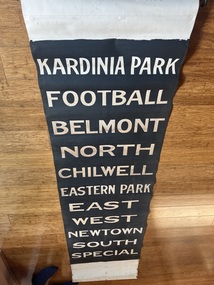
Functional object - Destination Roll, State Electricity Commission of Victoria (SECV), " Geelong" (black background) - side destination roll, 1946
Destination roll used to indicate to passengers the destination or route of the tram. At night the roll was backlit by two light bulbs fitted to the destination box on the tram. Item used in Geelong until 1956. Based on the handwritten marking, painted in July 1946. Used on the side destinations of either the Pengelley or the trams built for MESCo trams such as Geelong No. 2. See Reg Item 2906 for another smaller side destination roll and 4122 for a wide roll fitted to bogie tram No. 39 and 9618 wide roll fitted to a Pengelley tram. Destinations have the same arrangement to that of item 2906.Yields information and demonstrates aspects about Geelong's destination rolls used in trams up to 1956 when the system closed.Destination roll - white lettering on black background - using black paint leaving the lettering transparent at night. Uses a book binders cloth. Attached to a wooden blind roller, as used in the destination box to keep the blind tight. Wooden roller has a "Hartshorns" and "Stewart Gladstone" name lable attached to it.In pencil as base of roll "Taubmans Black 4-7-46 JS" tram, trams, geelong, destination roll -
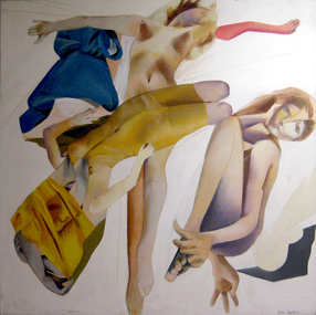 Federation University Art Collection
Painting - Acrylic on canvas, 'Glade of the Mystique Seductress' by Julie Watkins, 1971
This painting is one of my key early works incorporating the Baroque dualities of theatrical drama and inner emotional worlds. Interpreting the Baroque subject of the Sacred and the Profane, the swirling diagonal composition of crossed figures, transparent and billowing drapery in contrasting colours and dramatically tense gestures, in this work combine to suggest both religious ecstacy and physical sensuality. The glade is portrayed as white light. It is the open space for the drama. One face gazes ambiguously at the viewer, questioning, whether she is - the willing but (guarded OR mysterious?) seductress the title suggests. Julie Watkins, 2015 Julie WATKINS (1949- ) In 1969 Julie Watkins completed an Associateship Diploma Fine Art-Painting at RMIT, and a Fellowship Diploma of Fine Art-Painting the year after. In 1973 she was awarded a Diploma of Education at Hawthorn State College. Julie Watkins worked as a TAFE teacher from1973 to 1978, then as a tutor for the Faculty of Architecture and the Built Environment at RMIT between 1979 and 1992. Between the years 2003 to 2003 she was a tutor at the University of Melbourne (Victorian College of the Arts. This item is part of the Federation University Art Collection. The Art Collection features over 2000 works and was listed as a 'Ballarat Treasure' in 2007.Acrylic on stretched canvas art, artwork, julie watkins, watkins, painting, acrylic on canvas, available, julie meyer -
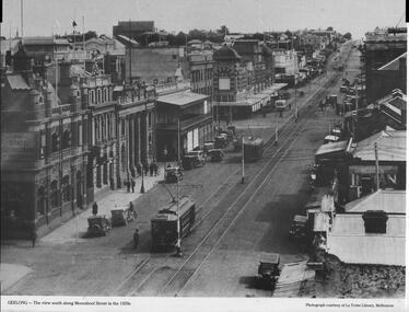 Ballarat Tramway Museum
Photograph - Illustration, La Trobe Library, "Geelong - the view south along Moorabool Street", late 1920s
Photograph shows Moorabool St looking south from near Corio St Geelong. Shows the track junction with Malop St. Has Pengelley built tram 22 southbound with a Birney tram in front. The two trams are going from the Wharf to Newtown and South respectively. In the background is the State Savings Bank, The Geelong Library, Solomons store, and a building advert sign for Dr Morses Indian Root Pills. There are many motor cars, some horse-drawn vehicles, and one bus in the view. Photo, late 1920s, sourced from the La Trobe Library Melbourne.Yields information about Moorabool St Geelong late 1920s.Publish Black and white photograph with caption and source printed along bottom edge.ballarat, trams, tramways, geelong, tram 22, birney tramcars, moorabool st -
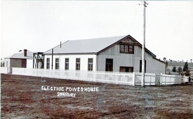 Sunbury Family History and Heritage Society Inc.
Photograph, Sunbury Powerhouse, c21st June 1910
The powerhouse in Sunbury began generating electricity for the town in 1908 after the Shire of Bulla saw the benefits of the town having electricity. It functioned until 1924 until the State Electricity Commission took over the project. The post card was written on 21 June 1910 and sent to a Miss Hillary who was living in Benalla. It was from her cousin Mr. Gregor who was a Sunbury resident. From the date on the card, the photograph must have been taken shortly after the powerhouse began operating. An engineer's cottage was built at the rear of the main building and it is still standing on its original site in Jackson Street,The establishment of an electricity supply for the town of Sunbury by the Shire of Bulla in the early decades of the twentieth century was a very advanced decision and brought lots of benefits to the town.A non-digital sepia photograph in post card format of the former Electric Powerhouse at Sunbury with a short message and address written on the back of the photograph To H.Hillary at Benalla from M.J.Gregor in Sunbury ELECTRIC POWERHOUSE/SUNBURY.electricity supplies., gregor, a., sunbury powerhouse -
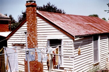 Surrey Hills Historical Society Collection
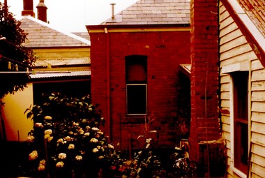
Photograph, Tavistock at 192 Union Road, 1978
The date is approximate. Tavistock was built c1890. In 1897 it was the home of the Walker family; Joyce Walker later became matron of Mosgiel Hospital. In 1902 it became the first site of Milverton Girls School. From 1930s to 1960s it was home to Miss Marjorie Vahland, a locally well-known nursing sister. This cottage is shown on the 1906 maps and also on a 1906 photo taken from Mosgeil Hospital in Mont Albert Road down Vincent Street. At this time there was no chimney on the cottage. See History Walks No 5, p 11 and p32 Surrey Hills In Celebration of its Centennial 1883-1983.Colour photo taken at the back of Tavistock at 192 Union Road, Surrey Hills. It shows a timber cottage painted in a light colour with a red corrugated iron roof (paint in a degraded condition) and a red brick chimney. The is a rotary clothesline in front of the cottage. Taken during the period of restoration of the property during 1978-1982.tavistock, milverton girls school, victorian style, houses, unionroad, 1890-1900, joyce walker, marjorie vahland -
 Surrey Hills Historical Society Collection
Photograph, Tavistock at 192 Union Road, 1978
The date is approximate. Tavistock was built c1890. In 1897 it was the home of the Walker family; Joyce Walker later became matron of Mosgiel Hospital. In 1902 it became the first site of Milverton Girls School. From 1930s to 1960s it was home to Miss Marjorie Vahland, a locally well-known nursing sister. This cottage is shown on the 1906 maps and also on a 1906 photo taken from Mosgiel Hospital in Mont Albert Road down Vincent Street. At this time there was no chimney on the cottage. See History Walks No 5, p 11 and p32 Surrey Hills In Celebration of its Centennial 1883-1983.Colour photo taken at the back of Tavistock at 192 Union Road, Surrey Hills. It shows part of a timber cottage painted in a light colour with a red corrugated iron roof (paint in a degraded condition) and a red brick chimney and the back of the main house. Taken during the period of restoration of the property during 1978-1982.tavistock, milverton girls school, victorian style, houses, union road, 1890-1900, joyce walker, marjorie vahland -
 Melbourne Tram Museum
Photograph - Black and white - Glenferrie Road, Glenferrie c1915
Shows Glenferrie Road, near Linda St looking south, c1915 prior to the construction of the Railway overpass at Glenferrie Railway Station with H class tram 58 in the view. The tram line was constructed in 1913. It would appear that the level crossing gates are closed in the photograph. The building on the right-hand side by the horse-drawn cart was an ANZ bank until 2021. The closer building, a theatre (The Palace) has since been demolished and is now a Coles Supermarket. The level crossing was replaced with an overbridge in April 1916. The church in the background is the Immaculate Conception Church, without the spires - built after WW1. Yields information about the location, the streetscape and the tram, vehicles in use at the time. Black and white photograph of Glenferrie Road Glenferrie with tram H58, looking south near Linda St, c1915."RSCP 327" & "C1920s" in pencil on rear and H58 in red ink.tramways, trams, glenferrie road, hawthorn, streetscapes, h class, tram 58 -
 Melbourne Tram Museum
Photograph - Black and White - PMTT bogie tram at Malvern Depot, 1913
Photo shows one of the Maximum Traction Bogies trams built for the Prahran and Malvern Tramways Trust by Duncan and Fraser of Adelaide in 1913. Photographed in the Malvern depot yard - shows the very sharp curves. Most likely a newspaper photograph reproduced by the donor. The trams were only numbered on their ends at this time. Has two uniformed tramway men standing by the drop centre doors. On the end of the building portal is a "1" - possibly indicating the depot road number that it was numbered from the north end when new, rather than the south end when the depot was expanded during the 1920s.Yields information about PMTT bogie trams when new.Photograph - Black and White - PMTT bogie tram at Malvern Depot c1913 tramways, trams, malvern, pmtt, malvern depot, bogie trams, maximum traction trams -
 Ballarat Tramway Museum
Photograph - Geelong power station, Melbourne Electric Supply Co. (MESCo), c1926
Photograph shows Geelong power station after completion. Power house building on the SW corner of Corio Tce. and Yarra Sts, Geelong, with new furnace room on the left, turret removed from the corner of the building, a third floor added on the Corio Tce. side but offices and concreted company name above where the trams entered the depot from the street not yet built. Date between 1924 and 1928 (based on photograph of Pengelly tramcar arriving and recently received, secondhand Melbourne tramcar). The ground floor offices facing Corio Tce. appear to be boarded up.Yields information about the Geelong Power station c1926Black and white print on paper.Plate number 1-8 in ink on back of photo.tramways, geelong, mesco, power station -
 Damascus College
Photograph, Opening of the Mount Xavier Golf Club
From 1949 golf became a regular part of a SHC student's week. With the junior SHC students educated at the Mount Xavier site since 1906, the land adjacent to 'Villa' as it was known, caught the eye of both keen golfer S. J. Weir and Mother Bonaventure Healy. Under their joint direction the golf course took shape, the first to be built and owned by a convent, and on any given Monday of the year could be found teeming with enthusiastic students from Sacred Heart College. Pictured centre left is Australian Minister for Immigration Arthur Calwell, whose daughter Mary attended SHC at that time.Digital Photograph -
 Bacchus Marsh & District Historical Society
Photograph, Court House Main Street Bacchus Marsh 1883
The Court House in Main Street Bacchus Marsh was built in 1858 using local sandstone. It opened in 1859. It has been used for jury trials, a Court of Petty Sessions, a County Court and a Crown Land sales office. Other uses included an office for the Registrar of Births and Deaths, a Dairy Inspectors office from 1863-1865, and as meeting rooms for the Bacchus Marsh Roads Board, a forerunner of the Shire Council. It was also used by the Bacchus Marsh Shire Council for its offices until at least 1884. In more recent years it has functioned as a Magistrates Court with weekly court sessions. Small sepia unframed photograph on card with gold border framing photograph. Housed in the album, 'Photographs of Bacchus Marsh and District in 1883 by Stevenson and McNicoll'. The view of the Court House building is seen from the northern side of Main Street looking south or south-east. Three men are standing in the street in front of the building. The men on the left and the right wearing police helmets appear to be police officers. The man in the middle is in civilian clothes and might be an officer or employee of the Court House. He has his dog with him. A white picket fence runs along the front of the building. The front courtyard of the building has been renovated since, but this building still operates as a court house.On the front: Stevenson & McNicoll. Photo. 108 Elizabeth St. Melbourne. COPIES CAN BE OBTAINED AT ANY TIME. On the back: LIGHT & TRUTH inscribed on a banner surmounted by a representation of the rising sun. Copies of this Portrait can be had at any time by sending the Name and Post Office Money Order or Stamps for the amount of order to STEVENSON & McNICOLL LATE BENSON & STEVENSON, Photographers. 108 Elizabeth Street, MELBOURNE. stevenson and mcnicoll 1883 photographs of bacchus marsh and district, courthouses, bacchus marsh court house -
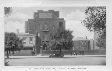 St Vincent's Hospital Melbourne Archives
Postcard, C.W. Series, Melbourne, St Vincent's Hospital, Victoria Parade, Fitzroy, Circa 1914
The postcard shows St Vincent's Hospital, on the northern side of Victoria Parade, Fitzroy, circa 1914. At left is the original hospital building, a converted terrace house, alongside the first purpose-built wing opened 1905 and the Cullen Wing (with facilities for medical students and residents) on the right. A group of two men and three boys stands on the footpath outside the Cullen Wing and a car is parked outside the main hospital building in the centre of the photograph. The reverse of the postcard is a letter from a niece to her uncle and aunt detailing their day trip into Melbourne, the places they saw, the people they met and the activities they took part in.This postcard is significant since it provides a rare view of the hospital from this location at this point in its history.Black and white postcard showing photograph of St Vincent's Hospital Melbourne on the front and a letter is written in pencil on the reverse.On the reverse is a handwritten letter in pencil from a niece to her aunt and uncle about a day trip they took into Melbourne. The message is dated January 27, 1914.st vincent's hospital melbourne, streetviews, postcards, hospital buildings, fitzroy -
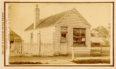 Bacchus Marsh & District Historical Society
Photograph, Saddlery Shop of George Taylor Main Street Bacchus Marsh 1883
This image is one of a series of photographs taken by Melbourne based photographers Stevenson and McNicoll who visited Bacchus Marsh and its nearby districts between September and November 1883. George Taylor was in business in Bacchus Marsh from 1866. He built these premises in Main Street in 1868 and remained in business until 1888 when Samuel Painter brought the property and operated his own saddlery business. The location was later used for the State Savings Bank of Victoria and the Bank of New South Wales (Westpac). The location of this site in 2024 is 136 Main Street, Bacchus Marsh.Small sepia 'carte de viste' style unframed photograph on card with gold border framing photograph. Housed in the album, 'Photographs of Bacchus Marsh and District in 1883 by Stevenson and McNicoll'. The image shows a single storey timber building with a pitched roof. The front of the gable has an ornamental wooden fretwork design attached.The name 'Taylor' can be clearly seen above the front door. There is one large window. The roof appears to be slate and the building has one chimney. Outhouses can be seen to the left and right of the building. There is a picket fence to one side of the building and a post-and-rail fence to the other.Printed On the front: Stevenson & McNicoll. Photo. 108 Elizabeth St. Melbourne. COPIES CAN BE OBTAINED AT ANY TIME. On the back: LIGHT & TRUTH inscribed on a banner surmounted by a representation of the rising sun. Copies of this Portrait can be had at any time by sending the Name and Post Office Money Order or Stamps for the amount of order to STEVENSON & McNICOLL LATE BENSON & STEVENSON, Photographers. 108 Elizabeth Street, MELBOURNE. stevenson and mcnicoll 1883 photographs of bacchus marsh and district, saddleries, saddlers -
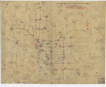 Melbourne Tram Museum
Drawing, Melbourne & Metropolitan Tramways Board (MMTB), "Route Map showing location of special work and pole numbers" "substations", late 1942
Map of the system shown at two inches = 1 mile. Drawing No. P5799. Shows crossovers, track layouts at junctions, signal cabins roads, railways, and stations. Originally signed by Perway Engineer - 20/12/1940, though originally drawn in 1922. The plan shows the lines to Maribyrnong Munitions works along Cordite Ave and Wests Road and the track from Moonee Ponds to Union Road, opened in July 1941, and the extension to Essendon Airport built in 1942, but not the Queen St North Essendon substation. Shows underground cables, tram and bus depot, workshop locations, and substation locations and their priority.Yields information about the MMTB substation locations in 1942.Drawing - dyeline cloth backed print - titled - "Route Map showing location of special work and pole numbers" and subtitled - "Substations". trams, tramways, mmtb, trackwork, tramways, junction, map, world war 2, substation -
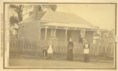 Bacchus Marsh & District Historical Society
Photograph, Parkside Cottage Main Street Bacchus Marsh 1883
This image is one of a series of photographs taken by Melbourne based photographers Stevenson and McNicoll who visited Bacchus Marsh and its nearby districts between September and November 1883. The house in the image is located at 82 Main Street Bacchus Marsh and as of 2024 is still occupied as a residence. The house was built in 1860 by William Watson for William Grant who leased the property to various tenants. From 1867 it was mainly leased to local doctors. The property stayed in possession of the Grant family for many years after this and was leased to many residents of Bacchus Marsh. The identity of the people in this 1883 photograph has not been established.Small sepia 'carte de viste' style unframed photograph on card with gold border framing photograph. Housed in the album, 'Photographs of Bacchus Marsh and District in 1883 by Stevenson and McNicoll'. The photo shows a single-storey brick cottage with a shingled hip roof with two chimneys visible. The cottage has a verandah with an ornamental barge board and pillars and a picket fence. Standing on the footpath are two women and two young girls. On the verandah of the house stands another woman holding a baby. Printed On the front: Stevenson & McNicoll. Photo. 108 Elizabeth St. Melbourne. COPIES CAN BE OBTAINED AT ANY TIME. On the back: LIGHT & TRUTH inscribed on a banner surmounted by a representation of the rising sun. Copies of this Portrait can be had at any time by sending the Name and Post Office Money Order or Stamps for the amount of order to STEVENSON & McNICOLL LATE BENSON & STEVENSON, Photographers. 108 Elizabeth Street, MELBOURNE. stevenson and mcnicoll 1883 photographs of bacchus marsh and district, houses bacchus marsh, william watson builder bacchus marsh -
 Kew Historical Society Inc
Photograph - Construction of the Eastern Freeway (F19), Ron Setford, March 1972
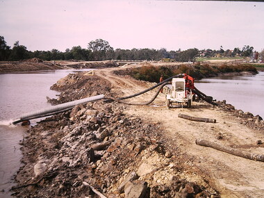
Ron Setford and his wife Grace Setford lived in Tanner Avenue, East Kew, from c.1946 to c.1995. A keen photographer, he recorded the changing face of Kew over a 20 year period. Apart from 30 photographs of built structures and places in Kew dating from 1960 and 1961, 145 of his 35mm colour slides chronicle the development of the F19 (later renamed Eastern) Freeway through the Yarra Valley in Kew over a five year period from c.1972 to c.1977. This important collection was donated to the Society by his granddaughter in 2025.This collection of 175 35mm slides is of local and statewide significance, owing to its subject matter, particularly the major development of road transport infrastructure during the 1970s with the construction of the Eastern Freeway. The photographer also took care to annotate and date most of his slides which enable the researcher to pinpoint temporal and spatial locations.Photograph of works involved in construction of the F19 (now Eastern) Freeway. The photo shows how construction sometimes took account of key environmental features; in this case the Kew Billabong."Eastern Freeway / "The Lagoon" to be saved at all costs"ron setford, eastern freeway, f19 freeway, kew billabong -
 Kew Historical Society Inc
Photograph - Construction of the Eastern Freeway (F19), Ron Setford, March 1972
Ron Setford and his wife Grace Setford lived in Tanner Avenue, East Kew, from c.1946 to c.1995. A keen photographer, he recorded the changing face of Kew over a 20 year period. Apart from 30 photographs of built structures and places in Kew dating from 1960 and 1961, 145 of his 35mm colour slides chronicle the development of the F19 (later renamed Eastern) Freeway through the Yarra Valley in Kew over a five year period from c.1972 to c.1977. This important collection was donated to the Society by his granddaughter in 2025.This collection of 175 35mm slides is of local and statewide significance, owing to its subject matter, particularly the major development of road transport infrastructure during the 1970s with the construction of the Eastern Freeway. The photographer also took care to annotate and date most of his slides which enable the researcher to pinpoint temporal and spatial locations.Photograph of works involved in construction of the F19 (now Eastern) Freeway. The photo shows how construction sometimes took account of key environmental features; in this case the Kew Billabong."Eastern Freeway / Sept 72"ron setford, eastern freeway, f19 freeway -
 Kew Historical Society Inc
Photograph - Construction of the Eastern Freeway (F19), Ron Setford, March 1972
Ron Setford and his wife Grace Setford lived in Tanner Avenue, East Kew, from c.1946 to c.1995. A keen photographer, he recorded the changing face of Kew over a 20 year period. Apart from 30 photographs of built structures and places in Kew dating from 1960 and 1961, 145 of his 35mm colour slides chronicle the development of the F19 (later renamed Eastern) Freeway through the Yarra Valley in Kew over a five year period from c.1972 to c.1977. This important collection was donated to the Society by his granddaughter in 2025.This collection of 175 35mm slides is of local and statewide significance, owing to its subject matter, particularly the major development of road transport infrastructure during the 1970s with the construction of the Eastern Freeway. The photographer also took care to annotate and date most of his slides which enable the researcher to pinpoint temporal and spatial locations.Kilby Rd, Willsmere Park on left"Eastern Freeway / Kilby Road / Nov 72"ron setford, eastern freeway, f19 freeway, willsmere park, kilby road -
 Kew Historical Society Inc
Photograph - Construction of the Eastern Freeway (F19), Ron Setford, March 1972
Ron Setford and his wife Grace Setford lived in Tanner Avenue, East Kew, from c.1946 to c.1995. A keen photographer, he recorded the changing face of Kew over a 20 year period. Apart from 30 photographs of built structures and places in Kew dating from 1960 and 1961, 145 of his 35mm colour slides chronicle the development of the F19 (later renamed Eastern) Freeway through the Yarra Valley in Kew over a five year period from c.1972 to c.1977. This important collection was donated to the Society by his granddaughter in 2025.This collection of 175 35mm slides is of local and statewide significance, owing to its subject matter, particularly the major development of road transport infrastructure during the 1970s with the construction of the Eastern Freeway. The photographer also took care to annotate and date most of his slides which enable the researcher to pinpoint temporal and spatial locations. Kilby Rd, Willsmere Park on left Kilby Rd, Willsmere Park on left" E Freeway Nov 1972"ron setford, eastern freeway, f19 freeway, willsmere park, kilby road -
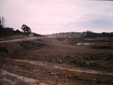 Kew Historical Society Inc
Photograph - Construction of the Eastern Freeway (F19), Ron Setford, March 1972
Ron Setford and his wife Grace Setford lived in Tanner Avenue, East Kew, from c.1946 to c.1995. A keen photographer, he recorded the changing face of Kew over a 20 year period. Apart from 30 photographs of built structures and places in Kew dating from 1960 and 1961, 145 of his 35mm colour slides chronicle the development of the F19 (later renamed Eastern) Freeway through the Yarra Valley in Kew over a five year period from c.1972 to c.1977. This important collection was donated to the Society by his granddaughter in 2025.This collection of 175 35mm slides is of local and statewide significance, owing to its subject matter, particularly the major development of road transport infrastructure during the 1970s with the construction of the Eastern Freeway. The photographer also took care to annotate and date most of his slides which enable the researcher to pinpoint temporal and spatial locations."Eastern Freeway 6/72 / Rock fill in old river bed"ron setford, eastern freeway, f19 freeway -
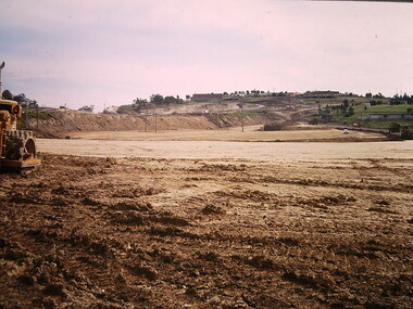
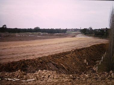 Kew Historical Society Inc
Photograph - Construction of the Eastern Freeway (F19), Ron Setford, March 1972
Ron Setford and his wife Grace Setford lived in Tanner Avenue, East Kew, from c.1946 to c.1995. A keen photographer, he recorded the changing face of Kew over a 20 year period. Apart from 30 photographs of built structures and places in Kew dating from 1960 and 1961, 145 of his 35mm colour slides chronicle the development of the F19 (later renamed Eastern) Freeway through the Yarra Valley in Kew over a five year period from c.1972 to c.1977. This important collection was donated to the Society by his granddaughter in 2025.This collection of 175 35mm slides is of local and statewide significance, owing to its subject matter, particularly the major development of road transport infrastructure during the 1970s with the construction of the Eastern Freeway. The photographer also took care to annotate and date most of his slides which enable the researcher to pinpoint temporal and spatial locations." Eastern Freeway 6/72 / Embankment approx half height"ron setford, eastern freeway, f19 freeway -
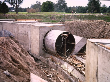 Kew Historical Society Inc
Photograph - Construction of the Eastern Freeway (F19), Ron Setford, March 1972
Ron Setford and his wife Grace Setford lived in Tanner Avenue, East Kew, from c.1946 to c.1995. A keen photographer, he recorded the changing face of Kew over a 20 year period. Apart from 30 photographs of built structures and places in Kew dating from 1960 and 1961, 145 of his 35mm colour slides chronicle the development of the F19 (later renamed Eastern) Freeway through the Yarra Valley in Kew over a five year period from c.1972 to c.1977. This important collection was donated to the Society by his granddaughter in 2025.This collection of 175 35mm slides is of local and statewide significance, owing to its subject matter, particularly the major development of road transport infrastructure during the 1970s with the construction of the Eastern Freeway. The photographer also took care to annotate and date most of his slides which enable the researcher to pinpoint temporal and spatial locations."Eastern Freeway 6/72 / Kew Main Drain extension under freeway"ron setford, eastern freeway, f19 freeway -
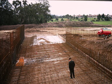 Kew Historical Society Inc
Photograph - Construction of the Eastern Freeway (F19), Ron Setford, March 1972
Ron Setford and his wife Grace Setford lived in Tanner Avenue, East Kew, from c.1946 to c.1995. A keen photographer, he recorded the changing face of Kew over a 20 year period. Apart from 30 photographs of built structures and places in Kew dating from 1960 and 1961, 145 of his 35mm colour slides chronicle the development of the F19 (later renamed Eastern) Freeway through the Yarra Valley in Kew over a five year period from c.1972 to c.1977. This important collection was donated to the Society by his granddaughter in 2025.This collection of 175 35mm slides is of local and statewide significance, owing to its subject matter, particularly the major development of road transport infrastructure during the 1970s with the construction of the Eastern Freeway. The photographer also took care to annotate and date most of his slides which enable the researcher to pinpoint temporal and spatial locations."Eastern Freeway 6/72 / Willsmere Park flood underpass"ron setford, eastern freeway, f19 freeway -
 Kew Historical Society Inc
Photograph - Construction of the Eastern Freeway (F19), Ron Setford, March 1972
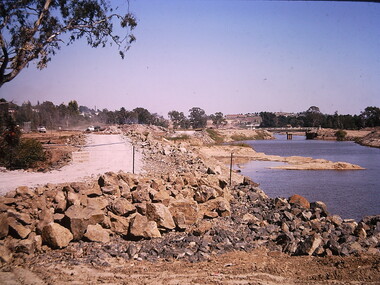
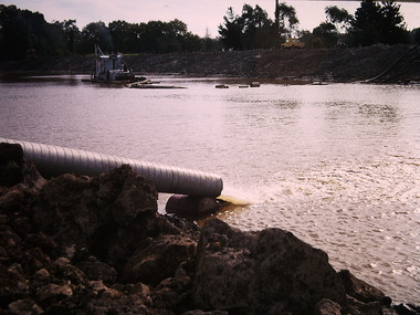
Ron Setford and his wife Grace Setford lived in Tanner Avenue, East Kew, from c.1946 to c.1995. A keen photographer, he recorded the changing face of Kew over a 20 year period. Apart from 30 photographs of built structures and places in Kew dating from 1960 and 1961, 145 of his 35mm colour slides chronicle the development of the F19 (later renamed Eastern) Freeway through the Yarra Valley in Kew over a five year period from c.1972 to c.1977. This important collection was donated to the Society by his granddaughter in 2025.This collection of 175 35mm slides is of local and statewide significance, owing to its subject matter, particularly the major development of road transport infrastructure during the 1970s with the construction of the Eastern Freeway. The photographer also took care to annotate and date most of his slides which enable the researcher to pinpoint temporal and spatial locations.Photograph of works involved in construction of the F19 (now Eastern) Freeway. The photo shows how construction sometimes took account of key environmental features; in this case the Kew Billabong."Eastern Freeway / pumping out of old river"ron setford, eastern freeway, f19 freeway -
 Kew Historical Society Inc
Photograph - Construction of the Eastern Freeway (F19), Ron Setford, March 1972
Ron Setford and his wife Grace Setford lived in Tanner Avenue, East Kew, from c.1946 to c.1995. A keen photographer, he recorded the changing face of Kew over a 20 year period. Apart from 30 photographs of built structures and places in Kew dating from 1960 and 1961, 145 of his 35mm colour slides chronicle the development of the F19 (later renamed Eastern) Freeway through the Yarra Valley in Kew over a five year period from c.1972 to c.1977. This important collection was donated to the Society by his granddaughter in 2025.This collection of 175 35mm slides is of local and statewide significance, owing to its subject matter, particularly the major development of road transport infrastructure during the 1970s with the construction of the Eastern Freeway. The photographer also took care to annotate and date most of his slides which enable the researcher to pinpoint temporal and spatial locations.Photograph of works involved in construction of the F19 (now Eastern) Freeway involving rerouting the River Yarra in Kew."Eastern Freeway / pumping out old river bed"ron setford, eastern freeway, f19 freeway -
![Photograph - Construction of the F19 [Eastern Freeway], Ron Setford, January 1973](/media/collectors/550653872162f11fb04854aa/items/67fb2edfa8240b7bcaf34522/item-media/67fb2f06a8240b7bcaf34747/item-fit-380x285.jpg) Kew Historical Society Inc
Kew Historical Society IncPhotograph - Construction of the F19 [Eastern Freeway], Ron Setford, January 1973
Ron Setford and his wife Grace Setford lived in Tanner Avenue, East Kew, from c.1946 to c.1995. A keen photographer, he recorded the changing face of Kew over a 20 year period. Apart from 30 photographs of built structures and places in Kew dating from 1960 and 1961, 145 of his 35mm colour slides chronicle the development of the F19 (later renamed Eastern) Freeway through the Yarra Valley in Kew over a five year period from c.1972 to c.1977. This important collection was donated to the Society by his granddaughter in 2025.This collection of 175 35mm slides is of local and statewide significance, owing to its subject matter, particularly the major development of road transport infrastructure during the 1970s with the construction of the Eastern Freeway. The photographer also took care to annotate and date most of his slides which enable the researcher to pinpoint temporal and spatial locations."Freeway at Willsmere u/pass / INF F9 125 SOC 2pm"ron setford, eastern freeway, f19 freeway -
![Photograph - Construction of the F19 [Eastern Freeway], Ron Setford, November 1972](/media/collectors/550653872162f11fb04854aa/items/67fb2de2a8240b7bcaf334be/item-media/67fb2e09a8240b7bcaf3366d/item-fit-380x285.jpg) Kew Historical Society Inc
Kew Historical Society IncPhotograph - Construction of the F19 [Eastern Freeway], Ron Setford, November 1972
Ron Setford and his wife Grace Setford lived in Tanner Avenue, East Kew, from c.1946 to c.1995. A keen photographer, he recorded the changing face of Kew over a 20 year period. Apart from 30 photographs of built structures and places in Kew dating from 1960 and 1961, 145 of his 35mm colour slides chronicle the development of the F19 (later renamed Eastern) Freeway through the Yarra Valley in Kew over a five year period from c.1972 to c.1977. This important collection was donated to the Society by his granddaughter in 2025.This collection of 175 35mm slides is of local and statewide significance, owing to its subject matter, particularly the major development of road transport infrastructure during the 1970s with the construction of the Eastern Freeway. The photographer also took care to annotate and date most of his slides which enable the researcher to pinpoint temporal and spatial locations."Approach to Chandler Highway / Nov 72"ron setford, eastern freeway, f19 freeway