Showing 11430 items
matching maps
-
 National Vietnam Veterans Museum (NVVM)
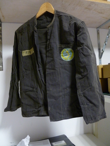
Uniform - Uniform, NVA, North Vietnamese Uniform
Black North vietnamese Uniform consisting of trousers and shirt. Shirt has a blue and yellow badge depicting map if Vietnam with words "To Quoc" and "Nhan-Dan" Name badge "I Minh 3"uniform, north vietnamese, to quoc, nhan-dan -
 Clunes Museum
Map, 1890
Features location of Club Hotel, Union Bank, Engine rooms, Port Phillip Hotel, Pyrites furnace, Battery, Office, Smith Shop,Surface Tramway to BatteryPhotocopy of map/plan of Dixon's New North Clunes, Central Clunes Co. and South Clunes utd showing various shafts and pre-emptive rights. Scale 1 inch = 100 feetOn front in red ink; "drawn in 1890"mine shafts, hotels, plans -
Clunes Museum
Map, CHARLES FENTON, TRADERS OF FRASER STREET CLUNES
4 X SHETS OF PAPER COMMECTED WITH STICKY TAPE SHOWING SHOPS OF FRASER STREET CLUNES WITH THE NAMES OF TRADERS AT EACH SHOP LOCATION. ALTHOUGH UNDATED IT IS EXPECTED THAT THIS MAP DATES TO APPROX 1870C1870fraser street, traders of clunes -
 Tatura Irrigation & Wartime Camps Museum
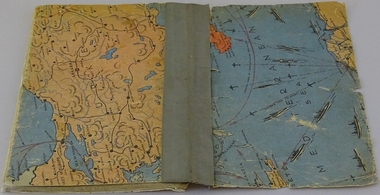
Book, Oswald Volkmann, Under Consideration, 1941
Booklet of poems in two languages by Dunera internee Oswald Volkmann, No.35271, at Camp 4, Tatura.Soft cover handmade/compiled book of typed poems. Covers feature maps (military). Inside front and back cover features sections of cartoons. Housed in a light green cardboard conservation box.Tatura 28 Okt 1941oswald volkmann, camp 4, internees, poetry -
 Uniting Church Archives - Synod of Victoria
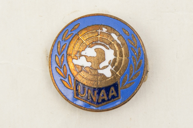
Badge
Small round metal and blue and white enamel United Nations Association of Australia badge with a pin fastening. The badge has a laurel wreath around its edge and a symbolic map at its centre."UNAA" -
Whitehorse Historical Society Inc.
Map, Melbourne and suburbs, 1923
Section of map 'Melbourne and Suburbs' compiled at the Department of Lands and Survey, Melbourne by E. S. Hilcke, March 1923, reprinted 1940.Section of map 'Melbourne and Suburbs' compiled at the Department of Lands and Survey, Melbourne by E. S. Hilcke, March 1923, reprinted 1940. Scale 40 chains: 1 inch. - Shire of Blackburn and MitchamSection of map 'Melbourne and Suburbs' compiled at the Department of Lands and Survey, Melbourne by E. S. Hilcke, March 1923, reprinted 1940.department of lands and surve, melbourne and suburbs -
Whitehorse Historical Society Inc.
Map, before 1890
Early map showing location and areas of plots and their owners' names between Heatherdale Road in the east and Springvale Road in the west, Burwood Road to the south to north of Canterbury Road. Later additions to 1969Early map showing location and areas of plots and their owners' names between Heatherdale Road in the east and Springvale Road in the west, Burwood Road to the south to north of Canterbury Road. Later additions to 1969Early map showing location and areas of plots and their owners' names between Heatherdale Road in the east and Springvale Road in the west, Burwood Road to the south to north of Canterbury Road. Later additions to 1969mitcham, vermont, nunawading -
Whitehorse Historical Society Inc.
Map, City of Whitehorse, 1/03/1995 12:00:00 AM
Map showing streets of the City of Whitehorse from Mullum Mullum Creek to the north to Highbury Road and Warrigal Road in the west, to Heatherdale Road in the east.Map showing streets of the City of Whitehorse from Mullum Mullum Creek to the north to Highbury Road and Warrigal Road in the west, to Heatherdale Road in the east. Prep. by Richard Meloni. Scale 1:15,000Map showing streets of the City of Whitehorse from Mullum Mullum Creek to the north to Highbury Road and Warrigal Road in the west, to Heatherdale Road in the east. city of whitehorse, mullum mullum creek -
 Whitehorse Historical Society Inc.
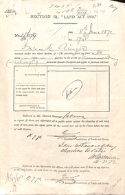
Document - Report, Section 31 Land Act 1869, 01/06/1872
Land application by Frank Ainger, referred to District Surveyor. Report by Mounted Constable Douglas with description of proposed use of land. Map of area. The area is on the corner of Whitehorse Road and Doncaster East Road.ainger, frank, douglas (mounted constable), assistant commissioner of lands and survey, whitehorse road, mitcham, doncaster east road, land settlement -
Whitehorse Historical Society Inc.
Map, M.M.B.W - Schwerkolt Cottage, 30/04/1968
Extract from M.M.B.W. map No 79 showing proposed main road, open space, residential zones C & D and location of Schwerkolt Cottage. Approved 40/04/1968. 2 copiesschwerkolt cottage, melbourne and metropolitan board of works, eastern freeway -
 Whitehorse Historical Society Inc.
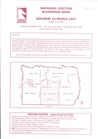
Document, Inaugural Election Blackwood Ward, 1/03/1997 12:00:00 AM
Notices to electors of Blackwood Ward. Includes city map with defined wards, list of polling places, candidate photographs and statements, voter eligibility and conditions for voting, Ward profile List of Streets and Results.city of whitehorse, seedsman, don, local government elections, white, david, way, kaele, van der heyde, sidney, athanasapoulos, michael, mckittrick, macdonald, terry, pierscionek, barbara, dixon, beverley -
 Whitehorse Historical Society Inc.
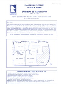
Document, Inaugural Election Morack Ward, 1/03/1997 12:00:00 AM
Notices of electors of Morack Ward. Includes city map with defined wards, list of polling places, candidate photographs and statements, voter eligibility and conditions for voting, Ward profile List of Streets and Resultscity of whitehorse, local government elections, dowey, robert, spurr, noel richard, bowie, bill, criddle, barbara, bhavnagri, nina, cooper, gary, chockalingam, karuppan -
 Ringwood RSL Sub-Branch
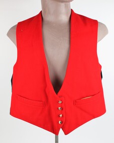
Uniform, Mess Dress, Evers and Cohen, All three items dated 1963
00134.1 Red Waistcoat with Gold Buttons QE2 crown and map of Australia, 00134.1 Dark Blue Cumbarbun with plastic fittings. 00134.3 Dark Blue Trousers with a single red stripe down the legs -
 8th/13th Victorian Mounted Rifles Regimental Collection
Photograph - WO2 Ernie Grant
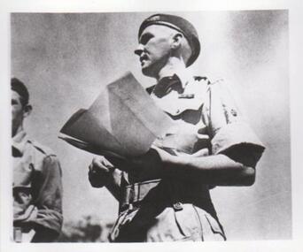
The 8th/13th Victorian Mounted Rifles was raised as a regiment of the Royal Australian Armoured Corps on 1 May 1948 with Headquarters in Melbourne and squadrons in Sale, Benalla/Wangaratta and Albury. In 1955 Regimental Headquarters moved to Wangaratta and a second squadron was located at Albury. The Sale squadron transferred to 4th/19th Prince of Wales’s Light Horse. In 1977 8/13 VMR Regiment was reduced to an independent squadron A Squadron 8th/13th Victorian Mounted Rifles and in 1991 was linked with 4th/19th Prince of Wales’s Light Horse forming the VMR Squadron of that regiment.Unique collection of photographs showing the first years of an armoured regiment of the post-Second World War era Citizen Military Forces showing equipment, uniforms, training and social activity and some personalitiesBlack and white photograph of soldier with map, Khaki drill uniform, w3b belt, beret, service ribbons.One of a collection of photographs of 8th/13th Victorian Mounted Rifles Regiment between 1948 and 1951.WO 11 Ernie Grantuniform, royal australian armoured corps, grant -
 8th/13th Victorian Mounted Rifles Regimental Collection
Photograph
The 8th/13th Victorian Mounted Rifles combined assistance to a Community Charity with a training exercise.Collection of photographs showing an armoured regiment of the Citizen Forces in the 1960s as it transitioned from wheeled armoured vehicles to tanks to M113 armoured personal carriers.Black and white photograph of 8/13 Victorian Mounted Rifles soldiers assembled in front of Humber trucks receiving orders from officer with map. Some are dressed in battledress, others in tank suits." Apex Wool Drive. 5th August 1961. Front: R. Bauerle, R. Almond, J. Warren, R. Ohlin. Rear: P. McLosley, -------, J. Farrelly, E. Roberts, B. Wilson, D. Anderson, P. Holmes." -
 Otway Districts Historical Society
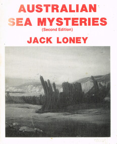
Book, Australian sea mysteries, 1988
Recalling ships that have explored, traded and plied the waters around the Australian coastline it tells of their changing fortunes, their shipwrecks and their incidents which have added to their sea mysteries.Australian sea mysteries. J.K. Loney. 2nd ed. nl; Marine History Publications; 1988. 116 p.; illus, maps, bibliography. Hard cover. ISBN 0 909191 28 Xaustralia; sea; j.k. loney; shipwrecks; oceans; -
 Otway Districts Historical Society
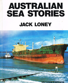
Book, Australian sea stories, 1989
Segments from our lesser known marine history.Australian sea stories. J.K. Loney. 2nd ed. Portarlington (Vic); Marine History; 1989. 152 p.; illus, maps, bibliography. Hard cover. ISBN 0 909191 34 4australia; j.k. loney; ships; shipwrecks; whaling; -
 Otway Districts Historical Society
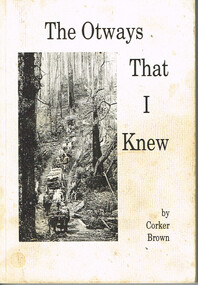
Book, Merimbula Easiprint, The Otways that I knew, 1993
Condensing 100 years of Otway history the author tries to give an insight into the thoughts and ways of the settlers in opening the western Otway Ranges. It gives some indication of the mental pressure, hand-in-hand with the physical stress, as a settler cleared the land and made a living for his family. It covers how the rail link brought in the timber mills and their workers which made timber the main industry of that era, and covers the changes that took place in the 1930s as the mills closed down and the district raised crops, dairying and grazing.The Otways that I knew. Ronald Charles 'Corker' Brown. 1st ed. Corker Brown; np; 1993. 216 p.; illus; maps. Soft cover. ISBN 0 646 16798 7otway ranges; corker brown; otway lighthouse; aborigines; beech forest; farming; grazing; crops; railways; roads; timber; -
 Otway Districts Historical Society
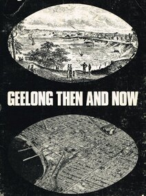
Book, Lothian Publishing Co. Pty. Ltd, Geelong - Then and Now, 1969
Geelong, second city of the state of Victoria, lies some 72 km. south west of Melbourne on the curve of Port Phillip Bay. This short history covers from the aborigines through to the mid-1960. Geelong - Then and Now. C.P. Billot. 1st ed. Melbourne (Vic)203mm x ; Lothian Publishing Co. Pty. Ltd.; 1969. iv, 44p.; illus., map. SBN 85091 109 5geelong; history; aborigines; corio shire; -
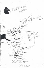 Bendigo Historical Society Inc.
Map - PETER ELLIS COLLECTION: MAP
Five photocopies of drawings of the Rushworth area and three copies of Rushworth-Whroo. All maps have various features and some plants noted. Also mentioned is the Balaclava Hill Open Cut Mine.map, victoria, rushworth/whroo, peter ellis collection, rushworth, whroo, aboriginal water holes, balaclava hill open cut mine -
Kew Historical Society Inc
Archive (Series) - Subject File, Cresco Reserve (Kew), 1958-present
Various partiesReference, Research, InformationSecondary Values (KHS Imposed Order)Subject file containing information on the Cresco Reserve at Kew Junction and its naming in c.2008. The file includes an item of correspondence from the City of Boroondara plus a print out of map of the Junction.cresco reserve, parks and gardens - -- kew -- boroondaracresco reserve, parks and gardens - -- kew -- boroondara -
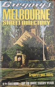 Kew Historical Society Inc
Book, Gregory's Publishing Company Pty Ltd, Gregory's Street Directory of Melbourne and suburbs and Metropolitan Road Guide, 1971
Street DirectoryRevised edition of Gregory's Directory including a series of road maps of Melbourne and its suburbs, newly extending to Lilydale, Mornington, Laverton, Deer Park, Epping, Diamond Creek, Olinda, Belgrave, and Doveton.non-fictionStreet Directorystreet directories - melbourne, gregory's street directories -
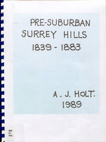 Surrey Hills Historical Society Collection
Book, Alan Judge Holt (deceased), Pre-Suburban Surrey Hills 1839-1883, 1989
Author: Alan Judge Holt amassed a significant collection of historical material related to the Surrey Hills area. Born in Moonee Ponds in 1912 to Edmund Holt and Ellen Ruby Sutton, he married Edna Jean Pallot in 1937. They lived at 62 Broughton Road, Surrey hills, had 3 sons and were strongly associated with the Surrey Hills Methodist Church. Alan was Secretary of the Victorian Lands Department and in his spare time recorded the occupancy of every property in Surrey Hills and Mont Albert at the beginning of each decade from 1890 to 1980. His collection of files and individual cards covers people, places, churches, clubs, businesses and other organisations in the area. Alan used this information to give talks and tours of the area and gifted his material to the local history collection through Jocelyn Hall.Unpublished manuscript / notes written by Alan Holt about settlers in and around Surrey Hills bound in-house. It is supported by maps showing landowners over various years from about 1840-1885(mr) henry jamieson, (mr) ken hall, (ms) edna holt, (mr) frank bamford, (mr) harrison buchanan, scouts, grange hill, wattle park, round hill, bona vista, mount albert, barton street, (mr) john raeburn, (mr) edmund holt, (mr) james dunn, butter merchant, mont albert road, elgar road, view hill, new street, surry mont, delany's hill, reservoir hill, riversdale road, middlesex road, surrey hills, (mr) aldo massora, aborigines, damper creek, back creek, west creek, kooyongkoot creek, (mr) john gardiner, (mr) chas mullins, (mr) henry elgar, (mr) robert campbell, (mr) alexander dyce, (mr) robert brooks, t budds payne, (mr) hugh glass, (mr) patrick trainer, w virtue, (mr) t fulton, (mr) john crimp, (mr) w dempsey, (mr) w e stanbridge, (mr) james atkinson, j porter, j collings, w edde, (mr) orlando fenwick, (dr)(mr) l l smith, (mr) j h knipe, (mr) george cockcroft, (sr) (mr) john martin kleinert, w morton, d delaney, a moeller, (mr) william smith, (mr) e.p.s.sturt, (mr) thomas blood, (mr) patrick mornane, (mr) henry de carle, w craig, j hill, w oliver, j keogh, a laing, vineyards, toll gates, (mr) david staig, (mr) phillip kleeper, (mr) goyder usher, (mr) james lawler, (mr) w.e. stanbridge, (mr) gideon rutherford, c a f mater, j gadsby, w h wrixon, e h lamont, i ainger, (mr) james henty, (mr) henry henty, w freemantle, w palmer, beckett park, maranoa gardens -
Canterbury History Group
Pamphlet - Range Estate, Canterbury, 1/04/1916 12:00:00 AM
Photocopy of a Coghill & Haughton brochure advertising the sale by auction of '19 superb Villa and Mansion' sites in Canterbury on 15 April 1916. Includes map of the allotments and photographs of five existing homes on the estate.canterbury, balwyn road, hopetoun avenue, mont albert road, view street, coghill & haughton, land sales, grange estate, auctioneers -
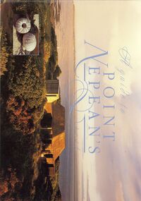 Bendigo Historical Society Inc.
Book - STRAUCH COLLECTION: A GUIDE TO POINT NEPEANS PAST
BHS CollectionA guide to Point Nepean's past by Harry Breidahl published by the Victorian Department of Conversation and Environment in association with Nautilus Educational Pty Ltd, 32 pages with photographs, illustrations & maps in black and white & colour.Harry Breidahlvictoria, history, nepean peninsula, victoria-history-point nepean -
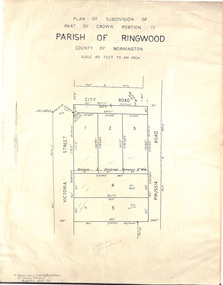 Ringwood and District Historical Society
Document - Folder, Plan of Subdivision - Part of Crown Portion 11, Parish of Ringwood - undated, circa 1950s
Buff coloured survey map of subdivision glued to manilla folder. Five residential blocks bounded by City Road, Victoria Street (later Ireland Street), and Prussia Road (later Regina Street).(Surveyor) R. James Love L.S. M.I.S. (Aust) M.A.I.C. 52 Comer Street Brighton East S6 Phone XB-5928 -
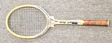 Wodonga & District Historical Society Inc
Functional object - Wooden Tennis Racquet, Dunlop Australia, c1950s
Dunlop first entered into the tennis sports equipment market in 1923 with Dunlop Tennis balls. They also produced tennis shoes and by 1932 Dunlop was manufacturing two million pairs a year. The Dunlop Maxply Tennis racquet was first produced in 1932 and dominated the wooden racquet market for the next 50 years. This racquet was made from a mix of nine different woods. The Maxply was favoured by legendary tennis players including Evonne Goolagong Cawley, Lew Hoad and Rod Laver who was using a Dunlop Maxply when he won all four Grand Slam tournaments in a row, something he achieved in 1962 and 1969. Sport activities including tennis have always been an important community pursuit in Wodonga and District. This racquet was used in competition at the Talgarno Tennis Club in the 1960s and 1970s.This item is significant because it represents a popular community activity and a successful manufacturer in Australia.A vintage wooden tennis racquet with a leather hand grip. It features coloured decals including the brand name added to the racquet head and the handle. There is also an outline map of Australia. The frame is also painted.On racquet frame: MAXPLY DUNLOP JUNIOR On handle: Your Servecommunity sport, wodonga and district, talgarno -
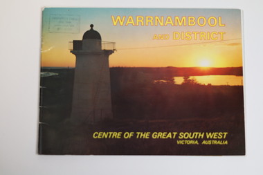 Warrnambool and District Historical Society Inc.
Booklet - Tourist Booklet, Warrnambool Chamber of Commerce and Industry, Warrnambool and District - Centre of the Great South West, Victoria, Australia, c. 1970
Warrnambool Tourist BookletThis is a booklet of 22 pages. The cover has two colour photographs and the pages contain a sketch map, printed text and colour photographs. The pages have ben stapled but the staples have been removed.non-fictionWarrnambool Tourist Bookletwarrnambool tourism, south west victoria tourist locations, warrnambool chamber of commerce -
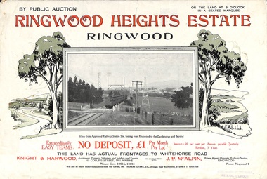 Ringwood and District Historical Society
Flyer, Subdivision Advertisement - Ringwood Heights Estate Public Auction - March, 1924
Refer also to Reg. No. 5185 for Ringwood Heights Estate final section release (August 1924)Folded double-sided brochure advertising Ringwood Heights Estate Public Auction on Saturday March 1, 1924, with town photographs, location map, terms of sale, and summary of local features and services.Subdivision includes Whitehorse Road, Bon View Avenue, Grant Crescent, Hillcrest Avenue, Heatherbrae Avenue, Margaret Street, and Mary Street. (Agents) Knight & Harwood, 315 Collins Street, Melbourne, Phones Central 10615, 10616, in conjunction with J.B. McAlpin, Opposite Railway Station, Ringwood, Phone Ringwood 7. -
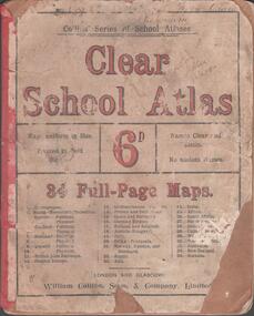 Bendigo Historical Society Inc.
Book - SCHOOL ATLAS, 1880s
Atlas. 34 page 'CLEAR SCHOOL ATLAS' in colour. Price sixpence. On the map of Australia, page 32, the location of Sandhurst is shown. Handwritten in ink at top of front cover, 'Fifth Class, Bamawm'William Collins, Sons & Company, London and Glasgoweducation, bendigo, atlas, bamawm, sandhurst