Showing 14725 items
matching south street
-
 Glenelg Shire Council Cultural Collection
Photograph - Photograph - Portland Harbour, n.d
Port of Portland Authority Archivesport of portland archives, portland harbour -
Glenelg Shire Council Cultural Collection
Photograph - Photograph - Early Shipping: Ocean/Railway Pier, n.d
Port of Portland Authority Archivesport of portland archives, portland harbour, ship berthed -
Glenelg Shire Council Cultural Collection
Photograph - Photograph - Main Breakwater Construction, n.d
Port of Portland Authority Archivesport of portland archives, portland harbour, ship berthed -
Glenelg Shire Council Cultural Collection
Photograph - Photograph - aerial view of Portland, 1960
Port of Portland Authority ArchivesBack: Aerial View South - July '60 -Top left, pencilport of portland archives, aerial photography, portland harbour -
Glenelg Shire Council Cultural Collection
Photograph - Photograph - Main Breakwater construction, Portland, 1959
Port of Portland AuthorityFront: ' View-southwest showing test on pile. '1959'-Black biro Back: View Southwest showing test on pile. 1959- Black biroport of portland archives, main breakwater, construction, harbour development -
Glenelg Shire Council Cultural Collection
Photograph - Photograph - Main Breakwater, Portland, n.d
Port of Portland Authority Archivesport of portland archives, main breakwater, construction, ocean pier, dutton way -
Glenelg Shire Council Cultural Collection
Photograph - Photograph - View of port and facilities, c. 1974
Port of Portland Authority archives.Front: (no inscriptions) Back: (no inscriptions)port of portland archives, portland harbour -
Glenelg Shire Council Cultural Collection
Photograph - Photograph - View of Portland Harbour and port, c. 1980
Port of Portland Authority archives.Front: (no inscriptions) Back: (no inscriptions)port of portland archives, portland harbour, lighthouse, caravan park, south portland, aluminium smelter -
Glenelg Shire Council Cultural Collection
Photograph - Photograph - Quarry, Pebbly Beach Blacknose Point, 05/11/1952
Port of Portland Authority ArchivesFront: 'PEBBLY BEACH 5..11.52 Looking south from Blacknose Point' Typed on bottom border Back: Purple PHT stamp 15/5 - top left in penport of portland archives -
Glenelg Shire Council Cultural Collection
Photograph - Photograph - Blacknose Quarry, 30/10/1952
Port of Portland Authority ArchivesFront: 'BLACKNOSE QUARRY FACE LOOKING SOUTH 30.10.52 FACE STRIPPED AFTER TRIAL BLAST' -Printed on bottom frame Back: Purple PHT stamp 5/4 crossed out - ink top leftport of portland archives, blacknose quarry -
Glenelg Shire Council Cultural Collection
Photograph - Photograph - Blacknose Quarry, n.d
Port of Portland Authority ArchivesBack: Purple PHT stampport of portland archives, blacknose quarry -
Glenelg Shire Council Cultural Collection
Photograph - Photograph - Blacknose Quarry, 30/10/1952
Port of Portland Authority ArchivesFront: 'BLACKNOSE QUARRY FACE LOOKING SOUTH 30.1.52 FACE STRIPPED AFTER TRIAL BLAST' -Printed on bottom frame Back: Purple PHT stamp 5/4 crossed out - ink top leftport of portland archives, blacknose quarry -
Glenelg Shire Council Cultural Collection
Photograph - Photograph - Blacknose Quarry Access Road, 29/09/1952
Port of Portland Authority ArchivesFront: 'Blacknose Quarry Access Road 25-9-52 Looking South' printed bottom fram Back: purple PHT stamp -
Glenelg Shire Council Cultural Collection
Map - Map - Western Victoria / South Australia, n.d
Port of Portland Authority Archivesport of portland archives -
Glenelg Shire Council Cultural Collection
Photograph - Photograph - Blacknos Quarry, 13/01/1953
Port of Portland Authority ArchivesBack: Purple PHT stamp '5/11' - top left, black ink, crossed out -
Glenelg Shire Council Cultural Collection
Photograph - Photograph - Cape Grant Quarry, 09/07/1954
Port of Portland Authority ArchivesBack: Purple PHT stampport of portland archives, cape grant quarry -
Glenelg Shire Council Cultural Collection
Photograph - Photograph - Lee Breakwater, Portland, n.d
Port of Portland Authority Archivesport of portland archives, portland harbour, lee breakwater, ocean pier, railway pier, construction -
Glenelg Shire Council Cultural Collection
Photograph - Photograph - Cape Grant Quarry, n.d
Port of Portland Authority Archivesport of portland archives, cape grant quarry -
Glenelg Shire Council Cultural Collection
Photograph - Photograph - Early Shipping: Ocean/Railway Pier, n.d
Port of Portland Authority ArchivesFront: Back- Shipping at Ocean Pier- Pencilport of portland -
Glenelg Shire Council Cultural Collection
Photograph - Photograph - Cape Grant Quarry, Portland, 03/08/1953
Port of Portland Authority Archives. From the Port of Portland website: Just 6km south of Portland, the Cape Grant Quarry is located on the eastern cliff of Cape Sir William Grant. This cape represents the core of a volcanic complex between two collapse calderas which underlie Nelson and Grant Bays to the west and east respectively. The Cape Grant quarry supplied an inexhaustible quantity of bluestone for the building of the new Portland harbour. The first stone was tipped at the root of the main breakwater on 17 November 1952. A small band of interested citizens were there to see the historic event. In the building, the breakwater was consolidated by the heavy traffic of Euclid’s and bulldozers and was further solidified by several storms that swept over it. Nowadays, blasting at the quarry is heavily regulated and carried out under the instructions of a qualified “powder monkey.” The days of seeing large explosions, along with the deep long loud BOOM are long gone with techniques of controlled blasting now improving overall environmental and safety standards.Front: Back- Purple PHT Stampport of portland archives, cape grant quarry, harbour development, construction -
Glenelg Shire Council Cultural Collection
Photograph - Photograph - Portland Harbour, 1940s
Port of Portland Authority ArchivesFront: Front- '1940's' - black textaport of portland archives, portland harbour, foreshore, ocean pier, railway pier, portland baths -
Glenelg Shire Council Cultural Collection
Photograph - Photograph - Blacknose Quarry Portland, 21/10/1952
Port of Portland Authority ArchivesFront: Front- Blacknose Quarry face 21/10/52 looking south showing rock brought down by trial blast'- Printed in bottom frame Back- Purple PHT Stamp 5/3- Ink, top leftport of portland -
Glenelg Shire Council Cultural Collection
Photograph - Photograph - Bridge Construction, Portland, n.d
Port of Portland Authority Archivesport of portland archives, canal bridge construction, harbour development -
Glenelg Shire Council Cultural Collection
Photograph - Photograph - Canal Bridge Construction, Portland, n.d
Port of Portland Authorityport of portland archives, portland harbour, harbour development, botanical gardens -
Glenelg Shire Council Cultural Collection
Photograph - Photograph - Cape Grant Quarry, Quarry, Cape Grant, 01/11/1956
Port of Portland Authority ArchivesFront: Back- Border ruled around in pencil. Cape Grant Quarry 1/11/56 'View to south east showing excavtor on limestone level, quarry master on 70ft level and box blast result on 40ft level in foreground. Note rock fave obscured by over burden material' - Pencil '5 x 3/4 approx' - pencilport of portland archives -
Glenelg Shire Council Cultural Collection
Photograph - Photograph - Bridge Construction, 02/12/1957
... Black and white photo of Finn Street bridge, looking south...Front: Back- 'Finn Street Bridge view to south west... Black and white photo of Finn Street bridge, looking south west ...Port of Portland Authority ArchivesFront: Back- 'Finn Street Bridge view to south west of completed bridge' - black pen 2/12/1957port of portland -
Glenelg Shire Council Cultural Collection
Photograph - Photograph - Railway Construction, Port of Portland, n.d
Port of Portland Authority Archivesport of portland archives -
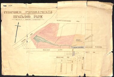 Ringwood and District Historical Society
Map, Proposed Improvements to Ringwood Park (Ringwood Lake) dated 14 January 1927
Proposed Improvements to Ringwood Park (Ringwood Lake) dated 14 January 1927, signed Cr McCaskill. Main Road is Whitehorse Road (Maroondah Highway), and Mt Dandenong Road is incorrectly labelled Whitehorse Road. The map shows Rosedale Crescent and Railway Parade, both of which exist in 2024. On the bottom of the map, south of the railway line, showing proposed streets - Graham Road, Anderson Street and Adams Street - in preparation for the sale of the Theo Anderson property. That area is now Bedford Park. -
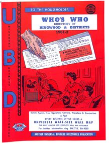 Ringwood and District Historical Society
Booklet, UBD Directory of Ringwood & Districts 1961-62
A Universal Business Directories Publication. Contains: Numerous advertisements by local business Summary of Ringwood services groups, wards, parks, schools, councillors, etc Doctor's Surgeries Index of streets Aerial maps Lists of businesses by business categories Includes the same for Croydon, Lilydale, Heathmont and Kilsyth. Some small business lists for Warrandyte, South Warrandyte, Vermont and Montrose. -
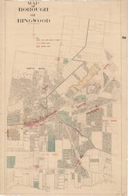 Ringwood and District Historical Society
Map, Borough of Ringwood, Victoria - c.1950s
A0-size (approx) map of named streets and lot-numbered properties within Borough of Ringwood ward boundaries. Colour-coded key marking Land Under Control of Council, Factory Areas, and Business Areas.Scale: 8 chains to 1 inch. North Ward, East Ward, South Ward.