Showing 1893 items
matching floods
-
 Ringwood and District Historical Society
Newspaper, Scrapbook Clipping, Library Collection, Ringwood, Victoria
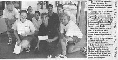
Newspaper Clipping from "The Post", Tuesday May 19 1998. P 31 A group of students from Norwood Secondary College, during a visit to the Northern Territory organised a sponsored climb of Ayers Rock. They managed to raise $620 and donated it to their peers at Katherine High School, which was damaged during recent floods -
 City of Ballarat
Artwork, other - Public Artwork, Travis Price, Main Road Mural by Travis Price, May 2018
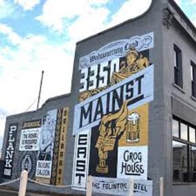
Whilst my main focus for the artwork design was on the Hotels on Main Road, I felt there was an opportunity to tell a broader story of Main Rd and combine/include some interesting pieces of information from many stages of the history of Main Road. Considering that at one point in time there would have been at more than six hotels in this very short section of street….there’s no doubt Main Rd was an epicentre of communication and festivities for the Goldfields of Ballarat. “No matter what luck he had, every miner needed supplies, food and something to entertain him when he was not searching for gold.” Described as being an overcrowded jumble of muddy streets loosely arranged around mining camps...and loud, muddy, colourful and sometimes illicit. I wanted the artwork composition to consist of overlapping images and text to reflect this sense of hustle and bustle. Main Road Mural tells the broader story of the history of Main Road in Ballarat. In 2018, the City of Ballarat commissioned local Ballarat artist Travis Price to create an artwork to align with the Main Road Revitalisation Project and deliver a key component of the storytelling (heritage interpretation) project that spans the length of the shopping precinct. The artwork is featured on a prominent site in the shopping precinct of main road and tells the story of Main Road through depicting key timeline events. Main Road, as its name suggests, was one of the main entries to the mining areas of East Ballarat. It had several names: Main Street before 1858, Plank Road between 1858 and 1868 and Main Road from 1868 onwards. The centre of mining life, it was crowded, prosperous, raucous and dirty. Painted mural on shop wall in Main Road, BallaratBallaarat, Gold Fever, The Royal Standard Hotel, Flood, Boxing Saloon, Plank Road, Kulin Nation, 3350, Election, East, Grog House, The Scandinavian Hotel. Images; Chinese lantern, Pick & Shovel, Miners Licence burning.main road history, ballarat hotels, gold fever, wadawurrung, kulin nation -
 Eltham District Historical Society Inc
Work on paper (Sub-Item) - Photograph, Nillumbik Park, Diamond Creek
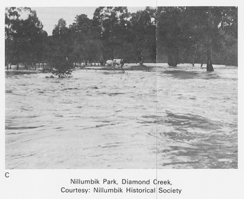
Undated black and white photograph of the Diamond Creek in flood, Nillumbik Park, Diamond Creek. Cattle take refuge on a high point. Nillumbik Historical Society collectionflood, diamond creek, nillumbik historical society -
 Ringwood and District Historical Society
Envelope, Packet: Objections - Correspondence (Ringwood) - Roads, Drains, Water, Rates etc. 1930s-1940s
Correspondence (mainly hand written) about objections to Roads; Correspondence (mainly hand written) about objections to Drains; Correspondence (mainly hand written) about objections to Wards; Correspondence (mainly hand written) about objections to Water; Correspondence (mainly hand written) about objections to Flooding; Correspondence (mainly hand written) about objections to Rates -
 Ballarat Tramway Museum
Newspaper, The Courier Ballarat, "Water Everywhere", 28/05/1963 12:00:00 AM
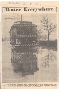
Yields information about the occasional weather conditions that a tramway operation around Lake Wendouree could encounter - flooding.Newspaper clipping from The Courier, 28/5/1963, titled "Water Everywhere", of No. 14 in water (blocked drain), Wendouree Parade & St Aidans Dve - wading through the floods. See Reg Item 3735 for a print of the photograph. Contained originally within Reg Item 5507 at the back of the binder. For items see btm5507 loose items list.pdf "Monday 27-5-63", in ink.wendouree parade, flooding, st aidans drive -
 Ballarat Tramway Museum
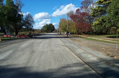
Photograph - Digital image Set of 12, Warren Doubleday, Wendouree Parade roadworks - April and May 2003, 27/4/2003 and 5/5/2003
Set of 12 Digital Images of the reconstruction of the roadway at the north end or near St Aidans drive that was part of the project to lift the road above flood level. Images show the work in progress and at the tram terminus itself. The gutter was moved to the north and later on the gate pillar was shifted to the north as well. Photos dated 27/4/2003 and 5/5/2003.trams, tramways, road works, st aidans drive, wendouree parade, tram track -
 Kew Historical Society Inc
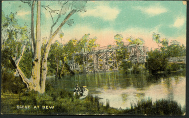
Postcard, AWR&Co, Scene at Kew, c.1907
Colourised pictorial postcard of the Zig-Zag Bridge at Kew. In the foreground is a rowboat in which a man is standing, behind whom are two women in hats and a young child. The man appears to be pushing the boat away from the Bank. In the distance is the wooden Zig-Zag Bridge, constructed in the 1870s to link the Yarra Bend and Kew Lunatic Asylums. [Destroyed by flood, 1929.]Text to Mrs Cooper from Grace ? inscription dated to 1907zig-zag bridge, yarra river -- kew (vic.), postcards -
 Kew Historical Society Inc
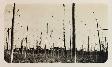
Photograph - Yarra at Kew, 1925
Henry Beater Christian (1886-1962) , was a descendant of one of the earliest settler families in Kew. Employed at the Kew Asylum as a 'public servant', he was a skilled amateur photographer, photographing numerous scenes in Kew and on his travels around Victoria. The majority of his photographs date from 1916 to 1929. His finest photographs are housed in two photograph albums. Digital copy of a photograph from page 4 of the 47-page photograph album containing 261 gelatinous silver images, loaned by Diane Washfold with permission given to digitise and hold a copy in our collection. This photograph of hop farming coveys the various uses for which low lying fertile flood prone land beside the Yarra River was used."Yarra at Kew"henry beater christian (1886-1962), landscape photography, kew (vic.) — yarra river, christian-washfold collection, photograph albums, agriculture, hop farms -
 Eltham District Historical Society Inc
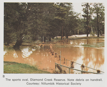
Work on paper (Sub-Item) - Photograph, The Sports Oval, Diamond Creek Reserve, Diamond Creek Township, 8 April 1977
Colour photograph. Note debris on the rail fencing around the oval. The Diamond Creek in flood at Diamond Creek township, 8 April 1977 Nillumbik Historical Society collectionflood, diamond creek, flooding, oval, nillumbik historical society, rail -
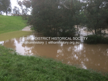
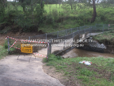
 Eltham District Historical Society Inc
Photograph - Digital Photograph, Carlota Quinlan, Diamond Creek in flood, Diamond Creek Trail, Eltham South, 16 Oct 2021
... floods ...diamond creek (creek), diamond creek trail, eltham south, flooding, floods, floodwater -
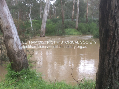
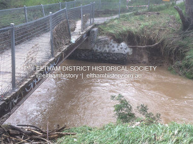
 Eltham District Historical Society Inc
Photograph - Digital Photograph, Carlota Quinlan, Diamond Creek in flood, Diamond Creek Trail, Eltham South, 16 Oct 2021
... floods ...diamond creek (creek), diamond creek trail, eltham south, flooding, floods, floodwater -
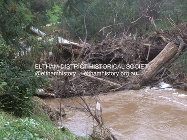
 Eltham District Historical Society Inc
Photograph - Digital Photograph, Carlota Quinlan, Diamond Creek in flood, Diamond Creek Trail, Eltham South, 16 Oct 2021
... floods ...diamond creek (creek), diamond creek trail, eltham south, flooding, floods, floodwater -
 Eltham District Historical Society Inc
Film - Video (Digital), Carlota Quinlan, Diamond Creek in flood, Diamond Creek Trail, Eltham South, 16 Oct 2021
... floods ...diamond creek (creek), diamond creek trail, eltham south, flooding, floods, floodwater -
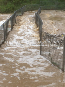
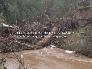
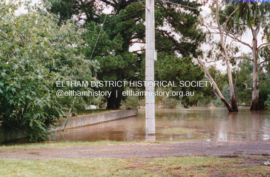
 Eltham District Historical Society Inc
Photograph - Digital Photograph, Carlota Quinlan, Diamond Creek in flood, Diamond Creek Trail, Eltham South, 17 Oct 2021
... floods ...diamond creek (creek), diamond creek trail, eltham south, flooding, floods, floodwater -
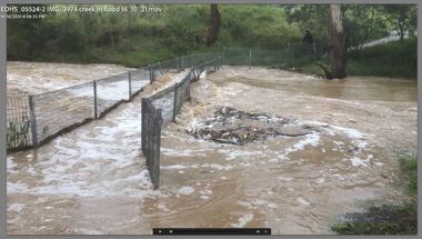
 Eltham District Historical Society Inc
Photograph - Digital Photograph, Carlota Quinlan, Diamond Creek in flood, Diamond Creek Trail, Eltham South, 17 Oct 2021
... floods ...diamond creek (creek), diamond creek trail, eltham south, flooding, floods, floodwater -
 Eltham District Historical Society Inc
Photograph - Digital Photograph, Carlota Quinlan, Diamond Creek in flood, Diamond Creek Trail, Eltham South, 17 Oct 2021
... floods ...diamond creek (creek), diamond creek trail, eltham south, flooding, floods, floodwater -
 Eltham District Historical Society Inc
Photograph - Digital Photograph, Carlota Quinlan, Diamond Creek in flood, Diamond Creek Trail, Eltham South, 17 Oct 2021
... floods ...diamond creek (creek), diamond creek trail, eltham south, flooding, floods, floodwater -
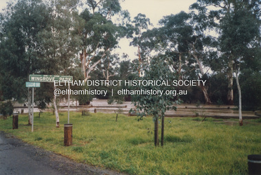 Eltham District Historical Society Inc
Photograph, Graeme Hardiman, Diamond Creek in flood, Wingrove Park, Main Road, Eltham, 6 June 1989
... floods ...diamond creek (creek), eltham, floods, floodwater, main road, wingrove park -
 Eltham District Historical Society Inc
Photograph, Graeme Hardiman, Diamond Creek in flood, Susan Street, Eltham, 6 June 1989
... floods ...Opposite P.J. Timber and Trading Co. Pty Ltddiamond creek (creek), eltham, floods, floodwater, p.j. timber & trading co pty ltd, susan street -
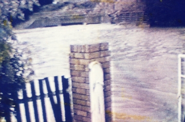
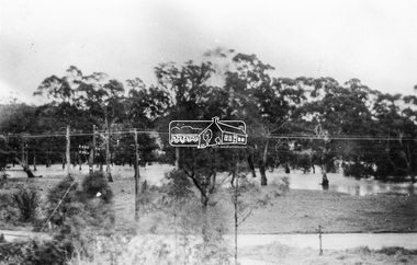 Eltham District Historical Society Inc
Photograph, Grace Mitchell, Diamond Creek in flood, Bremners Flat, Main Road, Eltham, c.1958
... floods ...View from Grace Mitchell's shop at the corner of Mount Pleasant Road and Main Road. Grace Mitchell was probably best known for her Eltham shop at the corner of Mt Pleasant Road and Main Road. Grace's memories covered many local identities who were patrons of her shop between 1954 and 1971. From the elevated position of her shop and home Grace was able to view a varied passing parade of Eltham events from ERSILAC, Easter and Eltham Festival parades passing on their way to Eltham Lower Park, circuses in Wingrove Park (then Bremner’s Reserve), roadworks and other happenings. Bremner's Reserve was renamed Wingrove Park c.1970 This photo was from a series of images presented by Grace Mitchell at a Society talk 10 March 1993 on the theme of “My Eltham”.Black and white print 17 x 25.4 cmbremner's flat, diamond creek, floods, main road, mount pleasant road, wingrove park -
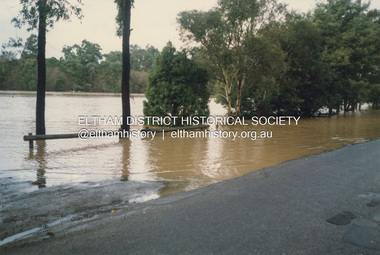
 Eltham District Historical Society Inc
Photograph, Floodwater, Diamond Creek, Eltham, Feb 2005, 2005
... floods ...Three colour photographs of the Diamond Creek floodwater; two at Antoinette Blvd and one on the Diamond Creek Trail near Lower Park, Feb 2005eltham, main road, diamond creek, floods, diamond creek trail, antoinette boulevard -
 Eltham District Historical Society Inc
Photograph, Floodwater, Diamond Creek, Eltham, February 2005
... floods ...Three colour photographs of the Diamond Creek floodwater; two at Antoinette Blvd and one on the Diamond Creek Trail near Lower Park, Feb 2005eltham, main road, diamond creek, floods, diamond creek trail, antoinette boulevard -
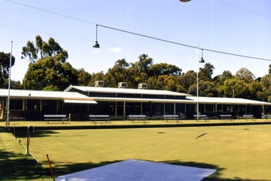
 Ringwood and District Historical Society
Photograph, Ringwood Bowling Club- Flooding of greens, 1989
Colour photographPhotograph was taken off the video shots taken by Jack Shandley. The flooding occurred on 10th April, 1989, when four inches of rain fell in 1½ hours. Photograph shows the height of the water in relation to the top of the Mullum Creek viaduct. -
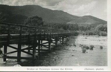 Kiewa Valley Historical Society
Photograph - Bridge at Tawonga 1936, 22/03/1936
First Tawonga bridge was built in 1884- destroyed by floods in 1916. New bridge constructed 1923 and destroyed in 1953. Present concrete bridge constructed in 1986 and named Ryders BridgeBridge construction over Kiewa River at TawongaBlack and white photographic postcard of the bridge at Tawonga across the Kiewa River.Handwritten in pencil on rear of photograph - Sunday 22nd March, 1936. Printed on front - Bridge at Tawonga across the Kiewa (Blumer, photo)tawonga bridge, kiewa valley -
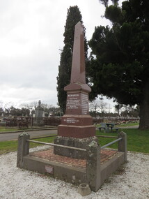 Ballarat Heritage Services
Photograph - Photograph - Colour, Clare Gervasoni, New Australasian Mine Disaster Memorial in Creswick Old Cemetery, 2018, 26/08/2018
The New Australasian Gold Mining Company's No 2 shaft was flooded on 12 December 1882, trapping 27 miners, 22 of whom died despite heroic efforts to save them. A number of photographs of the memorial to those who died in the New Australasian Mine Disaster, including names of those who died.new australasian mine disaster memorial, creswick cemetery, creswick old cemetery -
 Whitehorse Historical Society Inc.
Photograph, Blackburn Bowling Club, 2012
First games played 1926. The Club was then situated in South Parade. Ladies were invited to join in 1927. The yearly fee was 1.10 sterling. In 1933 the green was officially opened by Robert Menzies. The clubhouse was finally completed in the late 1940's. By the 1960's membership had risen to the extent that a new site was needed. A site on the east side of Pakenham Street, south of the creek, was proposed but it was subject to flooding. In 1966, after the flooding of the creek was managed, the South Parade property was acquired and the new greens were ready by September 1966.Coloured photograph of the Blackburn Bowling Club, Pakenham Street Blackburn. Photograph shows rinks in front of the club house - 2012blackburn bowling club, sporting clubs, pakenham street, blackburn -
Bendigo Historical Society Inc.
Newspaper - LYDIA CHANCELLOR COLLECTION: A DEADLOCK OVER LAST MINE
A Bendigo Advertiser article titled 'A Deadlock Over Last Mine.' The Wattle Gully goldmine at Chewton may close due to an impasse between the Mines Department and the management of the Wattle Gully mine. The issue of flooding of the 382 metre shaft wasn't being addressed according to the mine manager. A photo of the Wattle Gully goldmine is included in the newspaper article. 08/07/1977.mine, gold, wattle gully, lydia chancellor collection, collection, mining, chewton, wattle gully goldmine, goldmine -
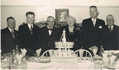 Bendigo Historical Society Inc.
Photograph - BERT GRAHAM COLLECTION: GROUP PHOTO
Black & white photograph, Bert Graham Collection, five gentlemen and one lady standing behind a table with a birthday cake for the 25th Anniversary of the Bendigo Progress Association, are as mentioned on the back, from left to right; Alwyn Nelson, Bert Graham, Jack Tully, Mrs. Tully, Tom Flood (Mayor), Tom Norris.There is an assortment of soft drinks on the table, sandwiches, and other cakes.bendigo, clubs, bendigo east progress association -
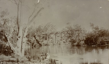 Kew Historical Society Inc
Postcard, River Yarra near Macauleys' Boathouse Kew
Sepia postcard of the Zig-zaf Bridge joining Yarra Bend and Studley Park. In the foreground is a rowboat in which a man is standing, behind whom are two women in hats and a young child. The man appears to be pushing the boat away from the Bank. In the distance is the wooden Zig-Zag Bridge, constructed in the 1870s to link the Yarra Bend and Kew Lunatic Asylums. [Destroyed by flood, 1929.]Obverse: "River Yarra near Macauleys' Boathouse Kew". Reverse: "Zig Zag Bridge / Gift from L Bennett 1980 / Bridge between Old Asylum & new Mental Hosp. / Kew side"zig-zag bridge -- kew (vic.), bridges -- river yarra, bridges -- kew (vic.) -
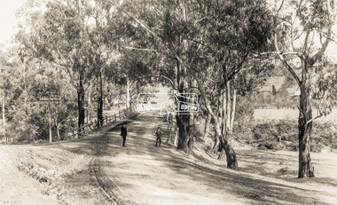 Eltham District Historical Society Inc
Photograph - Photograph postcard, The Rose Stereograph Company, View at Eltham, Vic. Postcard sent from Ernest and family to Joe, 3 May 1936, c.1920
Postcard sent from Ernest and family to Joe, 3 May 1936. Original photo estimated to be circa 1920. Looking west across the original Main Road Bridge and the Diamond Creek from near the intersection of Antoinette Boulevard. To the right of the bridge appear to be orchard trees in flood waters. The long wooden suspension bridge over the Diamond Creek on Main Road at Eltham collapsed during flooding of the Diamond Creek on October 13 and 14, 1923. The original bridge was built around 1840 for the coach road when Cobb & Co.'s coach was the only conveyance between Eltham and Melbourne. Widespread damage was done in Melbourne and surrounding areas by floods resulting from the overflow of the Yarra at many points along its banks. A temporary bridge rigged up was severely damaged by the flooding of the creek and was closed to vehicular traffic in April 1924. A new concrete bridge was constructed to replace it and by May 1926 all the concrete piles and abutments had been completed. The bridge was finally completed and opened for traffic in September 1926, almost three years after it initially collapsed. The Rose Series P. 4346 Postcards scanned from the collection of Michael Aitken on loan to EDHS, 13 Feb 2018Digital file only Postcards scanned from the collection of Michael Aitken on loan to EDHS, 13 Feb 2018michael aitken collection, postcards, main road bridge, main road, eltham, antoinette boulevard, diamond creek (creek), eltham south