Showing 25242 items
matching north
-
 Ringwood and District Historical Society
Photograph, The Telecom gang laying pipes in Kubis Drive, North Ringwood, near Jenkins Close, on 10th June 1978
E550 N5 Part of a 51-photo record of the development of the "Kubis" Estate, Ringwood North, including road works to Debbie Place, Kubis Drive, Werac Drive, Manuelo Drive, Iluka Place and Glenvale Road. From the Jack Lundy Clarke collection. -
 Ringwood and District Historical Society
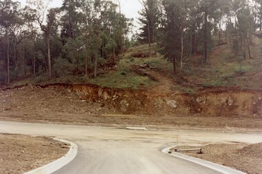
Photograph, Looking east up the gully over the intersection of Werac and Kubis Drives, North Ringwood, in February 1978
E546 N3 Part of a 51-photo record of the development of the "Kubis" Estate, Ringwood North, including road works to Debbie Place, Kubis Drive, Werac Drive, Manuelo Drive, Iluka Place and Glenvale Road. From the Jack Lundy Clarke collection. -
 Ringwood and District Historical Society
Photograph, Corner of Pamela Court and Kubis Drive, North Ringwood, looking west on 3rd November 1978
E551 N15 Part of a 51-photo record of the development of the "Kubis" Estate, Ringwood North, including road works to Debbie Place, Kubis Drive, Werac Drive, Manuelo Drive, Iluka Place and Glenvale Road. From the Jack Lundy Clarke collection. -
 Ringwood and District Historical Society
Photograph, Looking west across Werac and Kubis Drives, North Ringwood, in April 1978. Loughnan's Lake site. The retaining wall was where the truck tracks disappear over thhe ridge. The spillway was at that spot
E548 N3 Part of a 51-photo record of the development of the "Kubis" Estate, Ringwood North, including road works to Debbie Place, Kubis Drive, Werac Drive, Manuelo Drive, Iluka Place and Glenvale Road. From the Jack Lundy Clarke collection. -
 Greensborough Historical Society
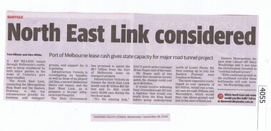
Newspaper Clipping, Diamond Valley Leader, North East Link considered, 28/09/2016
The proposed North East Link will connect the Western Ring Road and the Eastern Freeway.News clipping, black text.north east link, western ring road -
 Stawell Historical Society Inc
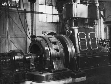
Photograph, North Western Woollen Mills -- Steam Driven Power Generator
North Western Woollen Mills Steam Driven Power Generator. Two copies.stawell industry -
 Stawell Historical Society Inc
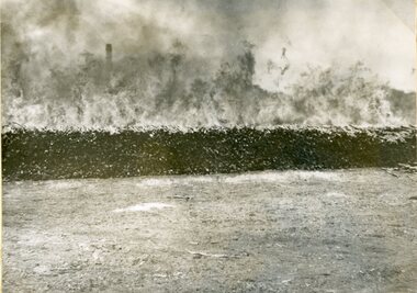
Photograph, North Western Woollen Mills -- Fire in Wood Stacks 1951 -- 4 Photos
Four photographs of North Western Woollen Mills Fire in Wood Stacks 1951stawell industry -
 Stawell Historical Society Inc
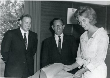
Photograph, North Western Woollen Mills -- Mr J M Bennett & Mr G S Bennett with a young Employee
North Western Woollen Mills J.M. Bennett & G.S. Bennett & Young Ladystawell industry -
 Stawell Historical Society Inc
Photograph, Wonga Campus Stawell Secondary College showing classrooms on North side 2000
Wonga Campus Stawell Secondary College 2000 showing classrooms on North sidestawell education -
 Friends of Ballarat Botanical Gardens History Group
Work on paper - The Gate Keepers Cottages, North Lodge and South Lodge, Ballarat Botanical Gardens
The Gate Keepers Cottages, North Lodge and South Lodge, Ballarat Botanical Gardens.john garner collection, ballarat botanical gardens, gate keepers cottage, cottage, gardens, ballarat -
 Carlton Football Club
Coloured Record, North Melbourne vs Carlton 1999 Grand Final Record
1999 AFL Grand Final was a battle between two powerhouse Victorian squads in Carlton and North Melbourne. With North under the supervision of Dennis Pagan, and the elite kicking of Wayne Carey, the blues couldn't keep up with the Roos, and ended up losing 19-10-124, to 12-17-89. -
 Greensborough Historical Society
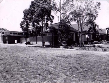
Article, Eltham North history, 1945o
A short history of the development of Eltham North including information on some of the early families in the area.Typed article of 4 pages. eltham north -
 Eltham District Historical Society Inc
Photograph, Looking south along Main Road from just north of Elsa Court, Eltham, February 1968, Feb 1968
Shows where the future duplication of Main Road ends just north of Elsa Court.In February 1968 an unknown person took a series of photos from the Eltham Hotel at Pitt Street heading north along Main Road through the shopping centre to just north of Elsa Court covering the length of the section of Main Road which was duplicated shortly thereafter. Shows the condition and environment of the streesscape of Main Road, Eltham immediately prior to the duplication between Pitt Street and Elsa Court through the shopping centre. Also shows a number of shops and businesses that operated at that time.Black and white photographduplication, eltham, main road, elsa court, railway line -
 Stawell Historical Society Inc
Photograph, Main Street Stawell looking North along Scanllan Street as viewed from the Town Hall Clock Tower c1991
View from Clock Tower looking North along Scallan Street approx 1991stawell -
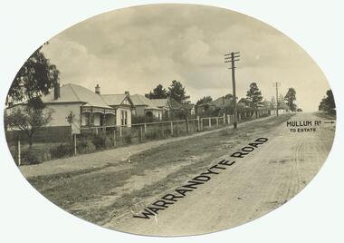 Ringwood and District Historical Society
Photograph, Warrandyte Rd. looking north past Mullum Rd(undated)
Dirt Road with houses. Text on photo states "Warrandyte Road" and "Mullum Rd To Estate"Typed below photograph, "Warrandyte Rd. looking north past Mullum Rd." On back of Oval copy of photograph (original?), is stamped the name "J.B. McAlpin, Estate and Financial Agent, District Government Valuer, Ringwood" -
 Ringwood and District Historical Society
Photograph, Kubis Drive and Debbie Place, North Ringwood, on 3rd November 1978, looking east
E551 N13 Part of a 51-photo record of the development of the "Kubis" Estate, Ringwood North, including road works to Debbie Place, Kubis Drive, Werac Drive, Manuelo Drive, Iluka Place and Glenvale Road. From the Jack Lundy Clarke collection.51 -
 Ringwood and District Historical Society
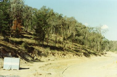
Photograph, Looking from Werac Drive, North Ringwood, on 14th April 1978, across the site of the headwaters of Loughnan's Lake. Main body of water lay to the left (west)
E548 N7 Part of a 51-photo record of the development of the "Kubis" Estate, Ringwood North, including road works to Debbie Place, Kubis Drive, Werac Drive, Manuelo Drive, Iluka Place and Glenvale Road. From the Jack Lundy Clarke collection.51 -
 Ringwood and District Historical Society
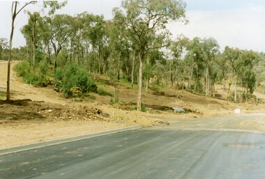
Photograph, Looking west from Kubis Drive, North Ringwood, in April 1978, over the full length of the site of Loughnan's Lake
E548 N5 Part of a 51-photo record of the development of the "Kubis" Estate, Ringwood North, including road works to Debbie Place, Kubis Drive, Werac Drive, Manuelo Drive, Iluka Place and Glenvale Road. From the Jack Lundy Clarke collection.51 -
 Ringwood and District Historical Society
Photograph, Looking up Debbie Place, North Ringwood, on 3rd November 1978, that has box sheet of metal
E551 N14 Part of a 51-photo record of the development of the "Kubis" Estate, Ringwood North, including road works to Debbie Place, Kubis Drive, Werac Drive, Manuelo Drive, Iluka Place and Glenvale Road. From the Jack Lundy Clarke collection.51 -
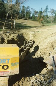
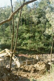 Ringwood and District Historical Society
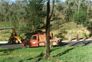
Photograph, Kato digging the 27-foot for the well at the pumping planty at Glenvale Road, North Ringwood, on 10th June 1978
E550 N4 Part of a 51-photo record of the development of the "Kubis" Estate, Ringwood North, including road works to Debbie Place, Kubis Drive, Werac Drive, Manuelo Drive, Iluka Place and Glenvale Road. From the Jack Lundy Clarke collection.51 -
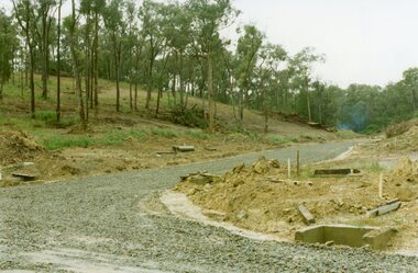
 Ringwood and District Historical Society
Photograph, Leaving Debbie Place, North Ringwood, now ready for metalling on 3 November 1978
E551 N12 Part of a 51-photo record of the development of the "Kubis" Estate, Ringwood North, including road works to Debbie Place, Kubis Drive, Werac Drive, Manuelo Drive, Iluka Place and Glenvale Road. From the Jack Lundy Clarke collection.51 -
Southern Sherbrooke Historical Society Inc.
Information folder - Aura Farm, "Aura, Our Memories Of The Farm At Narre Warren North (1922-1941", 1990s
Black plastic folder with sheet protectors, containing memories of Aura Farm in Narre Warren North. Contents:/title page/photograph of farmhouse (photocopy)/typed copy of handwritten document/handwritten accounts by Heather James and Mavis Hanna of life on their grandparents' farm (photocopies).oram family, narre warren north -
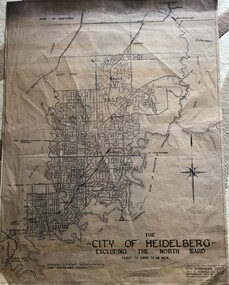 Greensborough Historical Society
Map, City of Heidelberg, City of Heidelberg, - excluding the North Ward, 1959, 27/05/1959
Map of City of Heidelberg showing municipal and ward boundaries; North Ward is excluded from this map.Blue print map"Scale 20 chns to an inch. G.M.H. 27.5.59"city of heidelberg, heidelberg - maps -
 Greensborough Historical Society
Newspaper Clipping, Diamond Valley Leader, CEO named to steer North East Link project, 01/03/2017
An engineer with decades of experience will be appointed chief executive of the new specialist North East Link Authority.News article 1 page, black text, colour image.north east link, metropolitan ring road, duncan elliott -
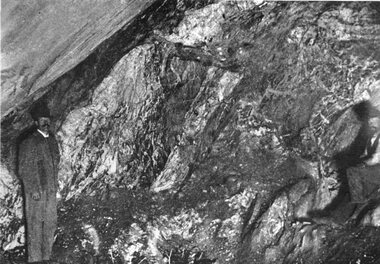 Stawell Historical Society Inc
Photograph, "Magdala-Cum-Moonlight" Mine at the Main stope of 1300 ft level looking North 1895
Mining Magdala-Cum-Moonlight 1895. Face in Main stope 1.300ft level looking North.stawell mining -
 Ringwood and District Historical Society
Photograph, The Kato working on the pumping plant at the end of the sewer trench near Glenvale Road, North Ringwood, on 10 June 1978. Loughnan's Lake site shown as a grassy hollow in the background
E550 N2 & N3 Part of a 51-photo record of the development of the "Kubis" Estate, Ringwood North, including road works to Debbie Place, Kubis Drive, Werac Drive, Manuelo Drive, Iluka Place and Glenvale Road. From the Jack Lundy Clarke collection.51 -
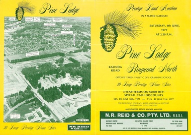 Ringwood and District Historical Society
Flyer, Land Auction Sale Brochure, Pine Lodge, Ringwood North, Victoria - 1977
Refer also to Reg. No. 5172 for Pine Lodge Land Auction 3rd release, 1978.Yellow double-sided real estate auction notice with green print showing aerial photograph and map of subdivision layout and summary of local features and services for Pine Lodge, Kalinda Road, Ringwood North. Auction date, Saturday, 4th June, 1977, at 2:30pm.Subdivision plan includes Parkgate Drive, Wood-Church Close, and Pensby Court. (Agent) N.R. Reid & Co. Pty. Ltd., Safeway Centre, Boronia Road, Boronia (Phone) 762 1022, 450 Little Collins Street, Melbourne (Phone) 67 1746, and 207 Stud Road, Wantirna South (Phone) 231 2277. -
 Greensborough Historical Society
Map, Melbourne and Metropolitan Board of Works. Survey Division, MMBW, Yarra 2500 / 15.21. Eltham North, 1979_08
Melbourne and Metropolitan Board of Works. Yarra 2500 [base map] 15.21. Eltham North. Parish of Nillumbik 3310. Municipalities of Diamond Valley 257 and Eltham 238. Prominent streets include: Progress Road, Glen Park Road and Zig Zag Road. Features include the Diamond Creek, Eltham Council Pound and Eltham North Reserve.MMBW Map in 1:2500 [scale] series. Cream parchment with green tape reinforcing on edges and punched holes on left edge.mmbw, melbourne and metropolitan board of works, shire of diamond valley, nillumbik, eltham - maps -
 Bendigo Historical Society Inc.
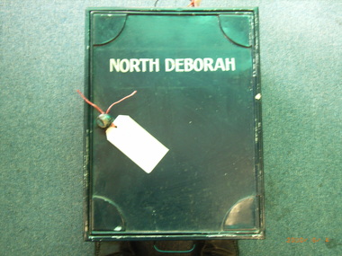
Archive - MCCOLL, RANKIN AND STANISTREET COLLECTION: NORTH DEBORAH GMC - MINE BOX 12, 1940's
Object. Metal mine box painted dark blue with North Deborah painted in white on the front. Formerly box 483 now North Deborah Mine Box 12. Box contains various documents relating to the North Deborah GMC. All individually catalogued within the box.North Deborahmining, business, mining box 12, mccoll, rankin & stanistreet, north deborah gmc, gold mining, mine box -
 National Wool Museum
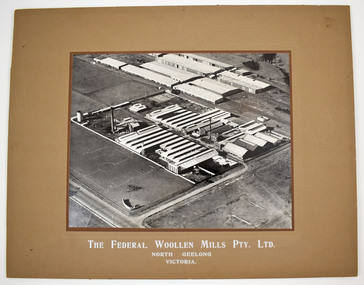
Photograph
Black and white mounted photograph of the Federal Woollen Mill Pty Ltd, North Geelong, Victoria - aerial view showing all buildings and grounds which includes 2 tennis courts in the background and 1 basketball court in the foreground. Negative and proof available currently held as film 48 frame 18.Black and white mounted photograph of the Federal Woollen Mill Pty Ltd, North Geelong, Victoria.The Federal Woollen Mills Pty. Ltd. North Geelong Victoriawoollen mills history, federal woollen mills ltd, woollen mills - history