Showing 2283 items
matching parish.
-
 Bendigo Historical Society Inc.
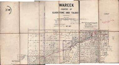
Map - JACK FLYNN COLLECTION: WAREEK, Examined 1918
Map: L.1053. Parish of Wareek, Counties of Gladstone and Talbot. Parish plan. Looks like half of the sheet is missing.Second Issue. Examined by S.F. Green. July 1918. William J. Swan, Draughtsman, August 1884. Photo-Lithographic Fac-Simile, W 36.map, gladstone, parish plan, wareek -
 Bendigo Historical Society Inc.
Map - TOWNSHIP OF KANGAROO FLAT, 27/01/1932
Map: Township of Kangaroo flat, Parish of Sandhurst , County of Bendigo. Parish plan ( number 194 in Map Cupboard 1)map, bendigo, township, kangaroo flat -
Bendigo Historical Society Inc.
Map - BOROUGH OF EAGLEHAWK, 30/11/1931
Map: Borough of Eagle hawk, Parish of Nerring. Parish plan with coloured areas ( number 185 in Map Cupboard 1)map, bendigo, parish plan, borough of eaglehawk, parish of nerring -
Bendigo Historical Society Inc.
Map - TOWNSHIP OF HEATHCOTE (PART), 11/04/1935
Map: Township of Heathcote (part), Parish of Heathcote, County of Dalhousie. Parish plan (number 259 in map cupboard 1)map, dalhousie, township, heathcote, copunty of dalhousie -
Bendigo Historical Society Inc.
Map - HUNTLY (PART) RESURVEY, Circa 1877
Map: Huntly [part) resurvey, Parish of Huntly, County of Bendigo. Parish plan ( number 243 in Map Cupboard 1)map, bendigo, parish plan, huntly -
Bendigo Historical Society Inc.
Map - PARISH OF EPPALOCK RESURVEY, 23/05/1876
Map: Parish of Eppalock resurvey, County of Bendigo, hand draughted Parish plan ( number 240 in Map Cupboard 1)map, bendigo, parish plan, eppalock, resurvey -
Bendigo Historical Society Inc.
Map - WESTON, 21/10/1876
Map: Re-Survey of part of the parish of Weston, County of Rodney. Parish plan (number 309 in map cupboard 1)Murray and Hargreave, Authorised surveyorsmap, rodney, parish plan, parish of weston, murray and hargreave -
Bendigo Historical Society Inc.
Map - GRAZING ALLOTMENTS, 15/10/1894
Map: Grazing Allotments, Parishes of Whirrakee and Bagshot, County of Bendigo. Parish plan (number 331 in map cupboard 1)map, bendigo, grazing allotments, grazing allotments, whirrakee, bagshot -
 Bendigo Historical Society Inc.
Map - EPSOM ?, Circa 1880
Map: Parish plan showing an area Southwards from the parish of Huntly boundary, Covering Epsom,Ascot and White Hillsmap, bendigo, parish plan, epsom, ascot, white hills -
Whitehorse Historical Society Inc.
Map, Plan of special survey selected by H. Elgar Esq, 1841
Photocopy of plan and listing of corner stakes.Photocopy of plan and listing of corner stakes. Note on verso: Plan of special survey selected by H. Elgar Esq in the Parishes of Boroondara and Nunawading, County of Bourke. Surveyed by T.H. Nott (?Sydney) 31 May 1841. Boroondara Special Survey B.17, with attached descriptive note by T. H. Nott.Photocopy of plan and listing of corner stakes. maps, parish of boroondara, parish of nunawading, elgar, h, nott, t.h. -
 St Kilda Historical Society
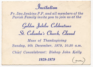
Ephemera - Invitation, Golden Jubilee Celebrations, St Columba's Church, Elwood, 1979
Invitation to a Mass of Thanksgiving in connection with the Golden Jubilee Celebrations of St Columba's Church, Elwood, on 9 December 1979. The St Columba Church and school is on the corner of Glenhuntly Road and Normandy Road, Elwood. The land was purchased in 1914. The school was built and opened first in 1918 and the church was completed and opened in 1929. The church is now part of the Catholic Parish of Sacred Heart and St Columba, serving St Kilda and Elwood communities.White card, discoloured with age, printed in blue on one side. Handwriting on both sides, in blue and blackHandwriting on back in black: Dearest Joan, This is our warm invitation, do hope you can come Mary. Handwriting on back in blue: Please come to the "Back to" in Parish Hall after Mass.churches, st columba's church, elwood -
Bendigo Historical Society Inc.
Map - BENDIGO WEST IRRIGATION SETTLEMENT, 27/07/1910
Map: bendigo West Irrigation Settlement, Parish of Sandhurst, County of Bendigo. Parish plan ( number 193 in Map Cupboard 1)map, bendigo, irrigation settlement, bendigo west irrigation settlement -
Bendigo Historical Society Inc.
Map - BENDIGO WEST IRRIGATION SETTLEMENT, 13/02/1909
Map: Bendigo West Irrigation Settlement, Parish of Sandhurst, County of Bendigo. Parish plan. ( number 191 in Map Cupboard 1)map, bendigo, irrigation settlement, bendigo west irrigatioon settlement -
Bendigo Historical Society Inc.
Map - TOWNSHIP OF HEAHCOTE SHEET 1, 29/07/1935
Map: Township of Heathcote sheet 1, parish of Heathcote, County of Dalhousie. Parish plan (number 253 in map cupboard 1)map, dalhousie, township, heathcote, conty of dalhousie -
Bendigo Historical Society Inc.
Map - PARISH OF EGERTON, 19/03/1894
Map: Parish of Egerton, Settlement on Lands Act 1893, County of Bendigo. Parish plan ( number 245 in Map Cupboard 1)map, bendigo, settlement on lands act 1893, egerton, settlement on lands act 1893. -
Clunes Museum
Map - CLUNES MAP SHOWING STREETS AND LOT NUMBERS
PURCHASED FROM DONORMAPS, PARISH OF CLUNES, CLUNES TOWNSHIPCLUNES TOWNSHIP AND STREETSlocal history, document, maps, clunes township -
Stawell Historical Society Inc
Map, T.F. McGauran, Winjallock County of Kara Kara, 1900
Noth of Navarre and BarkleyA2 Map0f Parish of Kara Kara.Photo Lithographed and the department of Lands & Survey, Melbourne by T.F. McCauran 22.10.00survey -
Bendigo Historical Society Inc.
Map - BENDIGO PARISH PLAN
BHS CollectionBendigo Parish Plan Section Kbendigo, land sales, parish map -
Bendigo Historical Society Inc.
Map - PARISH OF SANDHURST 1961, 1961
BHS CollectionAt Bendigo Parish of Sandhurst. Sheet F.Dept of Lands and Surveybendigo, land sales, parish map -
Bendigo Historical Society Inc.
Map - PARISH OF SANDHURST 1961, 1961
BHS CollectionAt Bendigo Parish of Sandhurst. Sheet 13Dept of Lands and Surveybendigo, land sales, parish map -
 Bendigo Historical Society Inc.
Map - REDCASTLE AND DARGILE, No date visible
Map: Redcastle and Dargile. Parish planPencil markings 27/6/78, 18/10/78map, parish plan, redcastle, dargile -
 Greensborough Historical Society
Map, Greensborough Map with Rail Line Plan, 1970s
Central Greensborough area, including railway line and some landowners. Basic map made c. 1902; annotations dated to circa 1970sTwo copies of planParish of Keelbundora, County of Bourke. Central Greensborough areagreensborough, greensborough railway station -
Bendigo Historical Society Inc.
Map - PORTION OF ELMORE ESTATE, 19/10/1920
Map: Portion of Elmore Estate, Parish of Egerton, County of Bendigo. Parish plan Canvas backed ( number 135 in Map Cupboard 1)map, bendigo, rural, elmore estate, egerton, county of bendigo -
Bendigo Historical Society Inc.
Map - PORTION OF ELMORE ESTATE, 19/10/1920
Map: Portion of Elmore Estate, Parish of Minto, County of Bendigo. Parish plan Canvas backed ( number 131 in Map Cupboard 1)map, bendigo, rural, elmore estate, minto, county of bendigo -
Bendigo Historical Society Inc.
Map - DINGEE SUBDIVISION, 25/11/1913
Map: Dingee Subdivision, Parishes of Talambe and Yallook, County of Bendigo, Parish Plan, Canvas Backed ( number 128 in Map Cupboard 1)map, bendigo, rural, dingee subdivision, talambe, yallook, county of bendigo -
Bendigo Historical Society Inc.
Map - RESURVEY PARISH OF SANDHURST, 23/07/1891
Map: Resurvey, Parish of Sandhhurst sheet No. IV, Enlargement of part of sheet No. III. Parish plan ( number 204 in Map Cupboard 1)map, bendigo, parish plan, parish of sandhurst, resurvey -
Bendigo Historical Society Inc.
Map - COUNTRY LANDS, 4/06/1874
Map: Country lands, Parishes of Goornong, Egerton, Elmore and Nolan, County of Bendigo. Parish plan (number 298 in map cupboard 1)map, bendigo, country lands, country lands, goornong, elmore, egerton, nolan -
Bendigo Historical Society Inc.
Map - AVAILABLE ALLOTMENTS, 10/08/1908
map: Available Allotments, Parishes of Whirrakee, Bagshot and Egerton, County of Bendigo. Parish plan (coloured) (number 330 in map cupboard 1)map, bendigo, allotments, available allotments, whirrakee, bagshot, egerton -
Lakes Entrance Historical Society
Book, Connelly, J.T, The First St. John's, Maffra, 1997
The story of the parish of St. Johns, Maffra, Victoria, and the first church building. A list of ministers includes the visiting missionaries before the establishment of the parish.religion -
Whitehorse Historical Society Inc.
Document, Certificate of Title, 1917 - 1933
Certificate of Title, Harrison Rotherham of 'Thulecroft', Albion Street, Surrey Hills, Merchant.Certificate of Title, Harrison Rotherham of 'Thulecroft', Albion Street, Surrey Hills, Merchant. Lots 61 & 62, subdivision 602, Part of Crown Allotment 127, Parish of Nunawading, County of Bourke with a right of carriage way over Harrison and Burnett streets, 1917. Vol 4046, Fol 809049. Also correspondence re rates, enforcement of charge, 1933.Certificate of Title, Harrison Rotherham of 'Thulecroft', Albion Street, Surrey Hills, Merchant.land titles, shire of nunawading, shire of blackburn and mitcham, rotherham, harrison, harrison street, mitcham, burnett street, mitcham