Showing 771 items
matching australian bird
-
 Federation University Art Collection
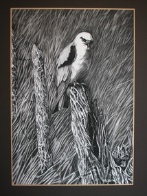
Drawing, Ron Walker, 'Black Hawk' by Ronald Walker, c1991
This item is part of the Federation University Art Collection. The Art Collection features over 2000 works and was listed as a 'Ballarat Treasure' in 2007.Drawing of a bird. If you are able to provide information on this artist or artwork please leave a message in the comment box below. art, artwork, ron walker, bird, federation college, drawing, available -
 Federation University Art Collection
Drawing - Drawing - Pen/wash drawing, 'Pale Sun Bird Rising', 1957
PETER CLARKE (1935 - ) Born Deloraine, Tasmania Peter Clarke was both artist and teacher. He held 14 exhibitions between 1957 and 1977, as well as participating in a number of group exhibitions, including Contemporary Australian Painting shown in Los Angeles and San Francisco. He is best known for large colour-field works. Peter Clarke's abstract painting emphasises texture, colour and gesture. He won the George Crouch Memorial Prize in 1967 This item is part of the Federation University Art Collection. The Art Collection features over 2000 works and was listed as a 'Ballarat Treasure' in 2007.Framed abstract drawing with wash.art, artwork, printmaking, peter clarke, mixed media, ballarat teachers' college collection, abstract -
 Federation University Art Collection
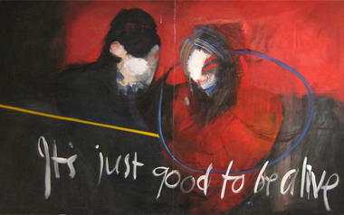
Painting, 'It's Just Good to be Alive' by Graham Bird, 1987
This item is part of the Federation University Art Collection. The Art Collection features over 1000 works and was listed as a 'Ballarat Treasure' in 2007. If you can assist with information on this artist or artwork please use the comment link below.art, artwork, graham bird -
 Federation University Art Collection
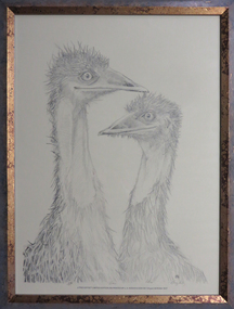
Drawing - Pencil drawing, Macqueen, Mary, 'Ostrich Cleaning' by Mary McQueen, 1980
This item is part of the Federation University Art Collection. The Art Collection features over 1000 works and was listed as a 'Ballarat Treasure' in 2007.Four drawings of an ostrich.art, artwork, mary mcqueen, ostrich, bird, pencil, pencil drawing, drawing -
![Work on paper - Offset print, Kwasniewski, Wojciech, 'Ptaki sa Wokol Nas' [Birds Are Around Us] by Wojciech Kwasniewski, 1990](/media/collectors/530576742162ef0fa09a2288/items/534748159821f420f8c0367c/item-media/60ab5512d932113f1da9353f/item-fit-380x285.jpg) Federation University Art Collection
Federation University Art CollectionWork on paper - Offset print, Kwasniewski, Wojciech, 'Ptaki sa Wokol Nas' [Birds Are Around Us] by Wojciech Kwasniewski, 1990
This item is part of the Federation University Art Collection and was purchased by the Art Acquisition Committee in 1996. The Art Collection features over 2000 works and was listed as a 'Ballarat Treasure' in 2007.Framed offset print exhibition poster.art, artwork, poster, wojciech kwasniewski, polish poster, bird -
 Federation University Art Collection
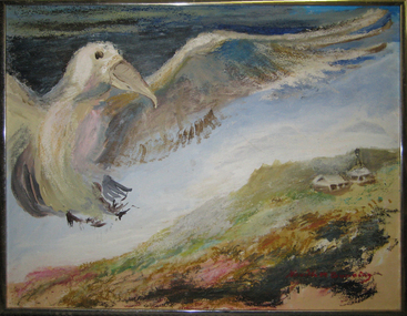
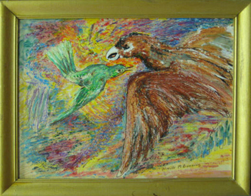
Painting - Artwork - Painting, 'The Absurd Bird' by Neville Bunning
This item is part of the Federation University Art Collection. The Art Collection features over 2000 works and was listed as a 'Ballarat Treasure' in 2007.Framed painting of a bird.art, artwork, neville bunning, bird -
 Federation University Art Collection
Oil on board, Neville Bunning, The Moon Bird [related to a larger painting]
This item is part of the Federation University Art Collection. The Art Collection features over 1000 works and was listed as a 'Ballarat Treasure' in 2007.Painting of a woman doing her hair in front of a bulldingart, artwork, neville bunning -
Federation University Art Collection
Ink on paper, Untitled - Birds
This item is part of the Federation University Art Collection. The Art Collection features over 2000 works and was listed as a 'Ballarat Treasure' in 2007.neville bunning, art, artwork -
Federation University Art Collection
Watercolour on paper, Neville Bunning, [Woman and Bird] by Neville Bunning
This item is part of the Federation University Art Collection. The Art Collection features over 1000 works and was listed as a 'Ballarat Treasure' in 2007.art, artwork, neville bunning, painting -
 Federation University Art Collection
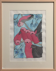
Painting, Gallahs
This item is part of the Federation University Art Collection. The Art Collection features over 2000 works and was listed as a 'Ballarat Treasure' in 2007.Framed watercolour of a number of gallahs in a tree. If you are able to provide information on this artist or artwork please use the email link below. art, artwork, birds, galahs, available, tafe business collection -
 Federation University Art Collection
Ceramic - Artwork, 'Falcon and Swift' by Brian Perry, 2008
This item is part of the Federation University Art Collection. The Art Collection features over 2000 works and was listed as a 'Ballarat Treasure' in 2007.Sculpture of a falconart, artwork, brian perry, falcon, bird, available, alumni -
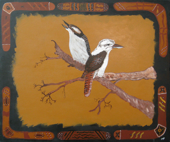 Federation University Art Collection
Painting - Acrylic on canvas, 'Kookaburras' by Harry Taylor, 1996
This item is part of the Federation University Art Collection. The Art Collection features over 2000 works and was listed as a 'Ballarat Treasure' in 2007.Painting of two kookaburras. If you can provide information on this artist or artwork please use the email link below.art, artwork, aboriginal, kookaburra, bird, harry taylor, horsham campus art collection -
Federation University Art Collection
Lithograph, Bower Bird
This item is part of the Federation University Art Collection. The Art Collection features over 2000 works and was listed as a 'Ballarat Treasure' in 2007.art, artwork -
 Federation University Art Collection
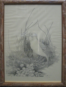
Lithograph, Earl Ingleby, Egret
This item is part of the Federation University Art Collection. The Art Collection features over 1000 works and was listed as a 'Ballarat Treasure' in 2007.art, artwork, birds, egret -
 Federation University Art Collection
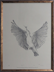
Artwork, 'Kingfisher' by Earl Ingleby
Earl INGELBY (1939- ) After training at RMIT in 1960s, Earl Ingleby worked and undertook further training in Europe before returning to Australia in late 1969. He currently lives and works in Creswick, Victoria. This item is part of the Federation University Art Collection. The Art Collection features over 2000 works and was listed as a 'Ballarat Treasure' in 2007.One in as set of three. .1) Lithograph of a kingfisherSigned and editioned at lower side "5/50 Kingfisher Litho E. Inglebyart, artwork, earl ingleby, j.a. hoskin, bird, kingfisher, available, fauna -
 Federation University Art Collection
Lithograph, 'Kite' by Earl Ingleby
Earl INGELBY (1939- ) After training at RMIT in 1960s, Earl Ingleby worked and undertook further training in Europe before returning to Australia in late 1969. He currently lives and works in Creswick, Victoria. This item is part of the Federation University Art Collection. The Art Collection features over 2000 works and was listed as a 'Ballarat Treasure' in 2007. Three framed lithographs featuring birds by Earl Inglby. The works are printedby J.A. Hoskin and Son. .1) Kingfisher .2) Kite .3) of a group of 3 framed lithographs. This work depicts a Kite. Gift in memory of Dr Janis Fraillon, Creswick 1990-2002Lower edge "5/50 Kite Litho E. Ingleby"art, artwork, earl ingleby, kite, bird, available, fauna -
 Federation University Art Collection
Lithograph, Earl Ingleby, 'Emu' by Earl Ingleby
This item is part of the Federation University Art Collection. The Art Collection features over 1000 works and was listed as a 'Ballarat Treasure' in 2007..2) of a group of 3 framed lithographs. This work depicts an emu.On lower side "5/50 Emu Litho E. Ingleby"art, artwork, earl ingleby, emu, bird, lithograph, available -
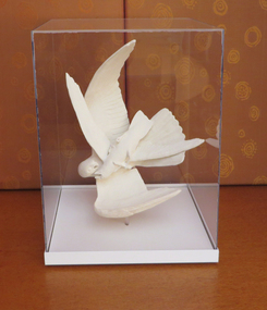
 Federation University Art Collection
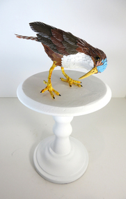
Artwork - Sculpture, Mairin Ni Shiochain, 'Untitled 13' by Mairin Ni Shiochain, 2012
Mairin Ni Shiochain Máirín Ní Shíocháin’s practice reflects a lifelong affinity with non-human animals. Her observation of animals and birds in natural habitats in and around Ballarat and district was the foundation for this research. She won a Ballarat Art Foundation Award in 2012. This item is part of the Federation University Art Collection. The Art Collection features over r000 works and was listed as a 'Ballarat Treasure' in 2007.Blue headed bird perched on a wooden stand. Individual feathers are made from paper, coloured with watercolour. art, artwork, mairin ni shiochain, bird, sculpture -
Federation University Art Collection
Collage, Justin Brown, [Bird on nest] by Justin Brown, c2005
This item is part of the Federation University Art Collection. The Art Collection features over 1000 works and was listed as a 'Ballarat Treasure' in 2007.art, artwork -
 Federation University Art Collection
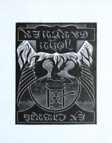
Bookplate, 'Ex Libris John Gartner'
John Gartner was a fine printer and publisher, an author, a noted philatelist, and also collector of Australian banknotes and coins. He was born on 16 July 1914 and was largely self-educated, leaving school at fourteen for work following the death of his father. Gartner developed a strong interest in the history of typography and printing and was apprenticed at the Advocate where his father had been a linotype operator. Aged 17, Gartner bought a hand press and some fonts of type, and in 1937 acquired a platen press from which he set and printed his private press books, published under the imprint of The Hawthorn Press. Gartner had a strong collection of Australian bookplates. He also looked at the work of artists overseas and commissioned personal plates. He subsequently built an international collection with preference for artists who printed from wood. His initial searches were in Belgium and Holland.(http://www3.slv.vic.gov.au/latrobejournal/issue/latrobe-84/t1-g-t7.html) Background has circle with printing press within. Circle is enveloped by the wings of a large bird, possibly an eagle. There are flames in the foreground.JV 646bookplate., keith wingrove memorial trust, australian bookplate design award, printmaking -
Federation University Art Collection
Bookplate, 'Ex Libris Zelma Gartner'
John Gartner was a fine printer and publisher, an author, a noted philatelist, and also collector of Australian banknotes and coins. He was born on 16 July 1914 and was largely self-educated, leaving school at fourteen for work following the death of his father. Gartner developed a strong interest in the history of typography and printing and was apprenticed at the Advocate where his father had been a linotype operator. Aged 17, Gartner bought a hand press and some fonts of type, and in 1937 acquired a platen press from which he set and printed his private press books, published under the imprint of The Hawthorn Press. Gartner had a strong collection of Australian bookplates. He also looked at the work of artists overseas and commissioned personal plates. He subsequently built an international collection with preference for artists who printed from wood. His initial searches were in Belgium and Holland.(http://www3.slv.vic.gov.au/latrobejournal/issue/latrobe-84/t1-g-t7.html) Bear sitting on a tree limb with some foliage and birds in the background skybookplate, australian bookplate design award, keith wingrove memorial trust, printmaking -
 Federation University Art Collection
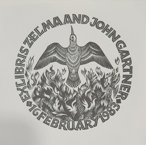
Work on paper - bookplate, ‘Ex Libris Zelma and John Gartner 16 February 1983'
John Gartner was a fine printer and publisher, an author, a noted philatelist, and also collector of Australian banknotes and coins. He was born on 16 July 1914 and was largely self-educated, leaving school at fourteen for work following the death of his father. Gartner developed a strong interest in the history of typography and printing and was apprenticed at the Advocate where his father had been a linotype operator. Aged 17, Gartner bought a hand press and some fonts of type, and in 1937 acquired a platen press from which he set and printed his private press books, published under the imprint of The Hawthorn Press. Gartner had a strong collection of Australian bookplates. He also looked at the work of artists overseas and commissioned personal plates. He subsequently built an international collection with preference for artists who printed from wood. His initial searches were in Belgium and Holland.(http://www3.slv.vic.gov.au/latrobejournal/issue/latrobe-84/t1-g-t7.html) A bird with outstretched wings is positioned vertically above leaves within the title which forms a circlebookplate, printmaking, australian bookplate design award, keith -
Federation University Art Collection
Bookplate, ‘Ex Libris John and Zelma Gartner’
John Gartner was a fine printer and publisher, an author, a noted philatelist, and also collector of Australian banknotes and coins. He was born on 16 July 1914 and was largely self-educated, leaving school at fourteen for work following the death of his father. Gartner developed a strong interest in the history of typography and printing and was apprenticed at the Advocate where his father had been a linotype operator. Aged 17, Gartner bought a hand press and some fonts of type, and in 1937 acquired a platen press from which he set and printed his private press books, published under the imprint of The Hawthorn Press. Gartner had a strong collection of Australian bookplates. He also looked at the work of artists overseas and commissioned personal plates. He subsequently built an international collection with preference for artists who printed from wood. His initial searches were in Belgium and Holland.(http://www3.slv.vic.gov.au/latrobejournal/issue/latrobe-84/t1-g-t7.html) A bird with outstretched wings and a crest of feathers on its head is depicted above the title.Audrey Hutchison England 1983 is printed on the back of the bookplatebookplate, australian bookplate design award, keith wingrove memorial trust, printmaking -
 Federation University Art Collection
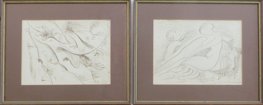
Artworks, 'The Proposal' and 'The Flight of Birds' by Neville Bunning
2 x framed ink drawings on paperboth signed in ink b.r. 'Neville Bunning'ink on paper, nude, neville bunning, available -
 Federation University Art Collection
Oil on card, 'My Territory' by Neville Bunning
This item is part of the Federation University Art Collection. The Art Collection features over 1000 works and was listed as a 'Ballarat Treasure' in 2007.Framed drawing of two birds.art, artwork, bunning, neville bunning, available -
 Federation University Art Collection
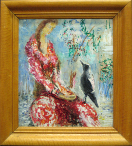
Oil on masonite, 'Bird Lover' by Neville Bunning
This item is part of the Federation University Art Collection. The Art Collection features over 2000 works and was listed as a 'Ballarat Treasure' in 2007.Framed painting of a woman in red dress with a magpie.art, artwork, neville bunning, bird, magpie, woman -
![Watercolour on paper, Neville Bunning, [Feeding Birds] by Neville Bunning](/media/collectors/530576742162ef0fa09a2288/items/534748179821f420f8c03917/item-media/55703bfc2162f116e4a710cf/item-fit-380x285.jpg) Federation University Art Collection
Federation University Art CollectionWatercolour on paper, Neville Bunning, [Feeding Birds] by Neville Bunning
This item is part of the Federation University Art Collection. The Art Collection features over 1000 works and was listed as a 'Ballarat Treasure' in 2007.art, artwork, neville bunning -
![Watercolour on paper, Neville Bunning, [Bird Feeding] by Neville Bunning](/media/collectors/530576742162ef0fa09a2288/items/534748179821f420f8c03919/item-media/599ffd0c21ea6d0cdce12e7a/item-fit-380x285.jpg) Federation University Art Collection
Federation University Art CollectionWatercolour on paper, Neville Bunning, [Bird Feeding] by Neville Bunning
This item is part of the Federation University Art Collection. The Art Collection features over 1000 works and was listed as a 'Ballarat Treasure' in 2007.art, artwork, framing required -
 Federation University Art Collection
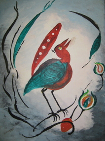
Oil on masonite, 'Song Bird' by Beville Bunning
This item is part of the Federation University Art Collection. The Art Collection features over 2 000 works and was listed as a 'Ballarat Treasure' in 2007.Painting of a bird with a red tail framed in aluminium. art, artwork, neville bunning, bird, available -
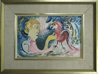 Federation University Art Collection
Painting, Neville Bunning, 'Scratch Cocky' by Neville Bunning
This item is part of the Federation University Art Collection. The Art Collection features over 2000 works and was listed as a 'Ballarat Treasure' in 2007.Framed paintingart, artwork, neville bunning, bird, available