Showing 174661 items
matching barkly-street
-
 Bacchus Marsh & District Historical Society
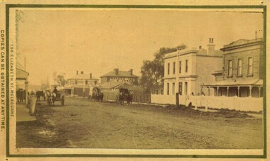
Photograph, Main Street Bacchus Marsh 1883 looking east
View of Main Street Bacchus Marsh 1883, showing early notable buildings on the southern side of the street, including the Courthouse, National Bank of Australasia, Border Inn, Hall of Commerce building. Small sepia unframed photograph on card with gold border framing photograph. Housed in the album, 'Photographs of Bacchus Marsh and District in 1883 by Stevenson and McNicoll'. Several horse-drawn vehicles can be seen travelling along an unmade road. Piles of excavated dirt can be seen along the side of the road. Four substantial two-storeyed buildings can be seen along the southern side of the street.On the front: Stevenson & McNicoll. Photo. 108 Elizabeth St. Melbourne. COPIES CAN BE OBTAINED AT ANY TIME. On the back: LIGHT & TRUTH inscribed on a banner surmounted by a representation of the rising sun. Copies of this Portrait can be had at any time by sending the Name and Post Office Money Order or Stamps for the amount of order to STEVENSON & McNICOLL LATE BENSON & STEVENSON, Photographers. 108 Elizabeth Street, MELBOURNE. stevenson and mcnicoll 1883 photographs of bacchus marsh and district, bacchus marsh roads and streets, bacchus marsh main street 19th century -
 Hume City Civic Collection
Print - Street Directory, Gregory"s Melbourne Street Directory, c1972
This street directory was published by Gregory's Guides & Maps Pty Ltd of 142 Clarence Street, Sydney NSW in c1972. It was used by the donor's family for many years to navigate their way around Melbourne and the metropolitan area. A street directory enclosed in a black leather detachable cover with gold embossing of a car on the front cover.Gold embossed vintage car on front of detachable cover.joan houston, streets, roads, maps, street directory -
 Surrey Hills Historical Society Collection
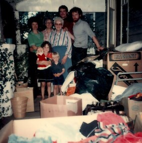
Photograph, 9 Vincent street, Surrey Hills
A colour photo of part of the interior of Mrs Mayer's house at 9 Vincent Street, Surrey Hills. It includes 3 women of varying ages, 2 men and 2 children, a boy and a girl. There are many boxes. at 9 Vincent st / Mrs Mayer's hospitality - / she was 80 y.o. / on her verandah / Pete[?] and Mike / & 2 chn there / for a fortnightwomen, children, men, verandah, boxes, toys, architectural features, personal effects -
 Kilmore Historical Society
Photograph, 5 Sydney Street, 2001
Connected with items: PHO-00010, PHO-00011 and PHO-00012.15cm x 10cm colour photograph of the cottage at the rear of Kilmore Communications, 5 Sydney Street. Printed on glossy photograph stock Konica brand. 2 photos included offering differing views of the property.Written on the back: Photo 1: Cottage at rear Former Kilmore Free Press Office 2001 5 Sydney St Photo: Heather Knight Photo 2: 5 Sydney St Cottage at rear shop - Kilmore Communications, former Kilmore Free Press Office. West side Sydney St, Kilmore, Opposite Husdon Park 2001 Photo: Heather Knight.real estate agents, cottages -
 Stawell Historical Society Inc
Photograph, Main Street Stawell -- Postcard
Pre Motor Vehicle Street Scape. Gas Light and Telephone pole in front of Post Office.B/W. Main Street. Post.Office. up people - 1 man crossing road in front of card, woman is riding a bicycle up the steet. A group o fmen in front of Post Office another on the Street.Ajax Series POSTCARD Address Only -
Federation University Historical Collection
Plan, University of Ballarat Camp Street Precinct, 2000, c2000
The university aspect of the Camp Street Precinct was named the arts AcademyFramed plans of the Univesity of Ballarat (later Federation University) Camp Street Precinct. .1) Drawing of elevations for the university of Ballarat and the City of Ballarat Camp Street Precinct elevations including a new performing arts Building, Mining Exchange, Visual Arts Building, and Alfred Deakin Place. .2) Camp Street Precinct elevations including the Ballarat Post Office, State Offices and Old Courthouse. camp street, camp street precinct, plans, daryl jackson, arts academy -
 Glen Eira Historical Society
Album - Album page, "Ripponlea", Hotham Street, Circa 1972
This photograph is part of the Caulfield Historical Album 1972. This album was created in approximately 1972 as part of a project by the Caulfield Historical Society to assist in identifying buildings worthy of preservation. The album is related to a Survey the Caulfield Historical Society developed in collaboration with the National Trust of Australia (Victoria) and Caulfield City Council to identify historic buildings within the City of Caulfield that warranted the protection of a National Trust Classification. Principal photographer thought to be Trevor Hart, member of Caulfield Historical Society. Most photographs were taken between 1966-1972 with a small number of photographs being older and from unknown sources. All photographs are black and white except where stated, with 386 photographs over 198 pages.From Victorian Heritage Database citation for Rippon Lea H0614 https://vhd.heritagecouncil.vic.gov.au/places/427(as at 23/10/2020) Rippon Lea was commenced in 1868 by Frederick Sargood, a most successful politician and merchant. He was born in England in 1834 and arrived in Melbourne in 1850. He soon joined his father's wholesale soft goods firm, spending some time as its manager on the goldfields. Sargood entered the Legislative Council in 1874. He was Victoria?s first Minister for Defence in 1883. Sir Frederick Sargood was created CMG. In 1885 and KCMG in 1890 as a reward for his contribution to public life. He died suddenly in 1903. Rippon Lea was designed by the leading firm of architects, Reed and Barnes. Joseph Reed had travelled in Europe in 1863, including northern Italy. When he returned he introduced the use of polychromy. While not the first examples, Rippon Lea and the Independent Church in Collins Street were the best and set a fashion which became a distinctly Melbourne style, particularly used for houses and churches. Its popularity was possible because of the new availability of different coloured bricks. Reed's fine Lombardic Romanesque details soon became debased by others. As Sargood's family grew and his fortunes prospered, Rippon Lea was extended to include 33 rooms - a complete mansion. The cast iron porte cochere and the northern conservatory were added in 1897. The architects were Taylor and Fitts. The ballroom was added in 1882 and remodelled in 1889. Many alterations have changed the interior and exterior during the ownerships of Benjamin Nathan and later his daughter Mrs Louisa Jones in the 1930s and are in their own right of significance. Sir Thomas Bent owned the property from 1903 until 1911 but never lived there. He subdivided much of the land. The original garden dates from about 1868, and it seems that William Guilfoyle of the Botanic Gardens was involved. It was redesigned in a more natural style in the 1880s by Sargood and his head gardener, Adam Anderson. The lake, waterfalls, fernery, hill and grotto are balanced by mighty deciduous trees and conifers. These are interspersed with, but never dominated by Australian species such as eucalyptus and other exotics. The sinuous drive with its carefully prepared approach to the house is notable. The original vegetable gardens, orchard and outer paddocks no longer survive. The shade house is important as the largest known in Australia and possibly the world. Its curved plan and form of construction are particularly notable. It was built about 1884.Page 94 of Photograph Album with four photographs (three landscape and one portrait) of Ripponlea - stables, lookout and neighbouring cottages.Handwritten: "Ripponlea" Hotham Street [top right] / Neg 256 Dec 1972 STABLES [under top left photo] / Neg 248 Dec 1972 LOOKOUT [under top right photo] / Neg 254 Dec 1972 / COTTAGES WILLOW STREET [under bottom left photo] / Neg 259 Dec 1972 STABLES [under bottom right photo] / 94 [bottom right]trevor hart, elsternwick, mansion, hotham street, frederick sargood, reed and barnes, 1860's, 1890's, 1880's, benjamin nathan, nathan, louisa jones, thomas bent, sir thomas bent, william guilfoyle, guilfoyle, adam anderson, ripponlea, victorian, sir frederick sargood, architects, bricks, polychrome bricks, taylor and fitts, stables, lookouts, cottages, outbuildings, rippon lea -
 Lakes Entrance Historical Society
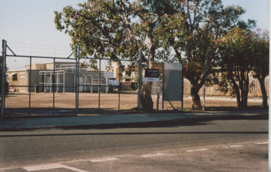
Photograph - Barkes Avenue Lakes Entrance Victoria, M Holding, 2006
R S L Anzac site in Barkes Avenue showing small brick building and cleared grounds enclosed by security fence site of earlier guesthouse Lakes Entrance Victoria. Also a colour photograph of Telstra building enclosed by security fence and shrubs Barkes Avenue 04283.1 size 10 x 15 cmColour photograph of R S L Anzac site in Barkes Avenue showing small brick building and cleared grounds enclosed by security fence site of earlier guesthouse Lakes Entrance Victoria. Also a colour photograph of Telstra building enclosed by security fence and shrubs Barkes Avenue 04283.1 size 10 x 15 cmbusinesses, township, roads and streets -
 Eltham District Historical Society Inc
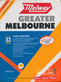
Book, Melway Publishing, Melway Greater Melbourne street directory : including Geelong, Phillip Island, Healesville, Kinglake, Gisborne, Lorne, Wallan, Bacchus Marsh Bellarine & Mornington Peninsulas; Edition 33, 2006, 2005
Edition 33. 2006 Coloured detailed maps accessed by a street or location index. Cover: Totally revised and updated with over 1380 new street listings new maps covering Mount Duneed on the Bellarine Peninsula, Pakenham South and Rythdale. Detailed public transport routes - train, tram, bus, bicycle paths & shared road routes. Eastlink fully detailed new Craigieburn bypass GPS compatible WGS/MGA Grid Special feature: New Hierachy of Roads Street directory with plastic cover, coloured maps, 902 pagesstreets,roads,melbourne,map,melway -
 Stawell Historical Society Inc
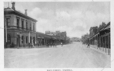
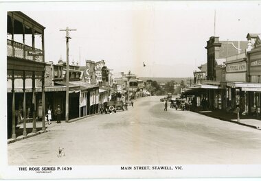
Photograph, Main Street Stawell looking west towards the Post Office Rose series 1639
This photograph is of Main Street Stawell lookingwest around c 1930's. The photo was taken from the Bull and Mouth Hotel whis is on the left side and other business. On the road are a few people and cars.Black and white Postcard Rose Series 1639 Looking down Main St From the Bull and Mouth Hotel Partially visable on the left. The Rose series, P 1639 Main Street, Stawell, Victoriastawell business shops streetscape -
 Eltham District Historical Society Inc
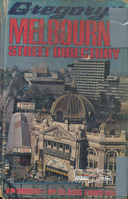
Book, Gregory's Melbourne Street Directory of Melbourne and suburbs and metropolitan road guide (8th edition) extends to Laverton, Deer Park, Epping, Diamond Creek, Lilydale, Olinda, Belgrave, Doveton and Mornington, 1973
This is the 8th edition of Gregory's Melbourne Street Directory, fully revised and up-to-date for this edition published December 1973. It is a comprehensive guide to the streets and localities of Melbourne and suburbs at that time. The colour maps are arranged in double-page spreads. Names of streets and suburbs are arranged alphabetically in the index to streets.Hard copy with plastic cover. 382 p. streets, melbourne - maps, roads -
 Bacchus Marsh & District Historical Society
Map, Main Road and Gell Street Allotments
This map shows allotments of land along Gell Street Bacchus Marsh running between Main Road (now called Main Street) and Lerderderg Street. The total area of the map encompasses Main Road, Church Street, Lerderderg Street and Gell Street. 36 allotments of land are shown. Three allotments which connect to Main Road are shaded in pink. The date of the map has not been established but the National Bank building erected in 1865 near the Border Inn is indicated which indicates that the map dates from after 1865. Reports in the Bacchus Marsh Express newspaper on 5 March 1870, page 2, column 6 announced building lots in Gell Street had been withdrawn from sale by the agent J.E. Crook. Later reports in the Express on 1 November 1873, page 2, column 2 advertised 14 allotments of land in Gell Street for sale. Single page map showing allotments of land along the Main Road (Main Street) and Gell Street areas of Bacchus Marsh. Part of a set of maps which are pasted into a bound volume containing 76 maps or plans in total. High resolution digital image stored on BMDHS computer network. bacchus marsh victoria maps, gell street land allotments, main street land allotments -
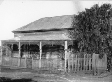 Stawell Historical Society Inc
Photograph, Upper Main Street Stawell with a Weatherboard Home – Reeve Family
The Photgraph of a Weatherboard Home which was situted Upper Main Street on the left side of the street– It was the home of the Reeve Family. Black and White photgraph of a weatherboard home with veranda across the front, around which a wooden fence and gateway, onto the street.stawell, reeve -
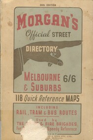 Surrey Hills Historical Society Collection
Book, Morgan's Official Street Directory, c1940s
incl.index. This Street Directory of Melbourne and suburbs, c1940s, includes a list of suburbs, their mileage from the city and how to reach them; an index to localities as well as the index to streets appearing on the maps. It also shows bus routes, railways and tramways routes on the maps.incl.index. This Street Directory of Melbourne and suburbs, c1940s, includes a list of suburbs, their mileage from the city and how to reach them; an index to localities as well as the index to streets appearing on the maps. It also shows bus routes, railways and tramways routes on the maps.melbourne metropolitian area, suburbs, cities and towns, maps -
 Eltham District Historical Society Inc
Photograph, Russell Yeoman, Looking south from Swan Street, Eltham, c,1965, 1965c
Shows Susan Street, Brisbane Street and Bridge Street. Large open field in centre now site of Bunnings The factory in lower centre on Brisbane Street is the Sibbel Builders factory of Martin and Herman Sibbel who were ahead of their time with design and prefabricated frames and also built cabinetry in this factory.Digital file only; created from original colour positive slide transparencyeltham, streets, susan street, bridge street, brisbane street, bunnings, ses, state emergency service, herman sibbel, martin sibbel, sibbel builders -
 Ringwood and District Historical Society
Photograph, Charter Street Ringwood Street Scenes 1981 (3 photos)
Street Scenes, Charter Street Ringwood, 6/6/1981 (3 photos)Written on back of original photos "6/6/81. Charter St. looking west from opposite no.40."; "No 40 Charter St", "No 42 Charter St" -
 Ballarat Heritage Services
Photograph, Clare Gervasoni, Brick Building on the Corner of South Street and Skipton Street, Ballarat, 2020, 13/04/2020
Colour photograph of a Brick Building on the Corner of South Street and Skipton Street, Ballarat.ballarat, south street, cast iron -
 Greensborough Historical Society
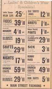
Advertisement - Digital image, Diamond Valley News, Main Street Fashions, 1964, 29/09/1964
Advertisement for Main Street Fashions, women's and children's wear, Main Street, Greensborough 1964Digital copy of newspaper advertisement.main street fashions, main street greensborough -
 Stawell Historical Society Inc
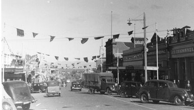
Photograph - Upper Main Street looking West, Upper Main Street with Bunting looking West & Named Shops in 2nd Photo -- 2 Photos
Main Street Stawell c 1940 On left Bike Shop, Carters Boot Shop. On right under town Hall Tower is Stawell Post Office, T. Browns Furniture / Coles / Eales, Geo Mitchell & Sons, Norman A. Harding Men's Wear. J.T. Chaponnel.Main street scene looking west with bunting across street. Many 1940's vehicles in streetboth driving and parked. Delivery truck at centre of image.stawell streetscape -
 St Kilda Historical Society
Photograph, Camden Street carpark Balaclava, 11/1962
Opening of carpark Camden Street Balaclava black and white photograph, unmounted, original, good conditionOn back: Car Park opening Camden Street Balaclava Nov 1962. From Leete Chemist -
 Melbourne Legacy
Slide, Legacy House in Market Street, 1957
A slide image of the old Legacy House in Market Street from 1957. It shows children and people gathered to go on an outing to the sea known for many years as Operation Float. It is taken from Collins Street looking down Market Street towards Flinders St. The entry to Legacy House is in the shadows to the left of the cream Matthew Lang building. Legacy rented the Market St premises for many years. It was part of the Western Market complex that was demolished and redeveloped in the early 1960s. Legacy held meetings and the girls classes on the second floor of the building but it was barely fit for purpose. In the 1940s a generous donation by an anonymous donor meant Legacy could purchase a building at 342 Swanston St, but due to several factors were never able to inhabit it. Finally it was sold in 1954 and Junior Legacy Melbourne purchased 289-299 Swanston Street Melbourne (previously called Red Cross House) in 1956 from the Commonwealth Government. As part of the conditions of the donation it was named in memory of David H Dureau. Renovations were needed to the 289-299 Swanston St building so this slide shows that Legacy were still in the Market St building in 1957 while they occurred. A record of the Market Street building that Legacy occupied for many years until 1956-7.Colour slide of Legacy House in Market Street from 1957.Slides has 'Operation Float 1957'. It is numbered '12' by the manufacturer.properties, market st, streetscape -
 Eltham District Historical Society Inc
Photograph, Cooks Cottage, Arthur Street, Eltham, c.1940s, 1940s
Sepia photograph of Ernie Andrews house, Arthur Street, Eltham c.1940s (now Safeway carpark)Site: Arthur Street, Eltham Now: Part of Woolworths, formerly Safeways Car Park Was: Known as Cooks Cottage Owner: Ernie Andrews, died 1950. House was demolished early 1950s See also: 00183arthur street, eltham, cooks cottage, ernie andrews, houses -
 Kilmore Historical Society
Photograph, 13 Sydney Street, 1970's
Was the site of J. Quinn Bakery.20cm x 12.5cm black and white photograph of the Breakells Bakery and shop at 13 Sydney Street. This photo was taken from the south side of the building. Pictured is the shopfront, the outside of the single story shop building and a light coloured two story building in a the back of the shop building. On the side of the building advertising for "Kayes Hair Boutique". At the front of the shop there is a sign for "Hot Food". And on the awning of the shop there are multiple signs including: "Milkbar", "Streets ice cream" and "Fresh bread, pies & pasties". Printed on standard card stock.Written on the back: 486 14-86-35bakers, baker and bakeries, bakeries, 1970's -
 Stawell Historical Society Inc
Photograph, Hobbs Family House at 10 Seaby Street Stawell 1997
Private Home - 10 Seaby Street (Hobbs) 1997. Built by Mary Ellen Hobbs widow of William Hobbs Paid for by proceeds of Mine Investments Later purchased by Frank & Lorraine Stokes.Brick House with brick front fence in Seaby Street Stawell.stawell -
Marysville & District Historical Society
Document (Item) - Research Document, Rene de Koning, Murchison Street Named After Roderick Impey Murchison (1792-1871), 13-08-2022
An account of the life of Roderick Impey Murchison whom Murchison Street in Marysville in Victoria is named for.An account of the life of Roderick Impey Murchison whom Murchison Street in Marysville in Victoria is named for. Roderick Murchison was one of the most distinguished geologists of the 19th century. His liberality and social position plus the pride he took in his science were of immense value in furthering the cause of learning in Britain.roderick impey murchison, murchison street, marysville, victoria, durham school, royal military college great marlow, peninsular war, charlotte hugonin, scotland, muir of ord, tarradale house, ross and cromarty, lower palaeozoic, old red sandstone, south wales, welsh borderland, the silurian system, graywacke rocks, adam sedgwick, permian, the geology of russia in europe and the ural mountains, siluria, cambrian system, silurian system, geological survey of great britain, geological society, the geographical society, british association for the advancement of science, wollaston medal, geology, geologist -
Marysville & District Historical Society
Document (Item) - Research Document, Rene de Koning, Darwin Street Named After Charles Robert Darwin (1809 - 1882), 13-08-2022
An account of the life of Charles Robert Darwin whom Darwin Street in Marysville in Victoria is named for.An account of the life of Charles Robert Darwin whom Darwin Street in Marysville in Victoria is named for. Charles Robert Darwin was an English naturalist, geologist, and biologist, widely known for his contributions to evolutionary biology. His theory that all species of life have descended from a common ancestor is now generally accepted and considered a fundamental concept in science. In a joint publication with Alfred Russel Wallace, he introduced his scientific theory that this branching pattern of evolution resulted from a process he called natural selection, in which the struggle for existence has a similar effect to the artificial selection involved in selective breeding. Charles Darwin has been described as one of the most influential figures in human history and is buried in Westminster Abbey. charles robert darwin, darwin street, marysville, victoria -
 Federation University Historical Collection
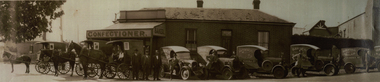
Photograph - Photograph - Black and White, Davies the Baker and Confectioner, 47 Eureka Street, Ballarat East, c1930, c1930
John Davies ran the bakery until 1923, at which time his son, Fred “F.T.” Davies, became proprietor. The business continued to grow under Fred, who turned it into one of the most successful industries in Ballarat. Fred fitted the bakery with a Perkins Continuous Oven, which was quite revolutionary for the time. The bakery was also fitted with Scotch ovens, which were used for ordinary bread-baking, and were worked manually. (https://bih.federation.edu.au/index.php/Davies_Bread)A number of horse drawn carriages, and motor vans in front of a building at 47 Eureka Street known as Davies the Baker. The three men standing together are Frederick Talbot Davies, John Davies and Hector Godfrey Smith (foreman). davies, davies bread, davies the baker, eureka street, horse, horse drawn carriage, confectioner -
 Ballarat Heritage Services
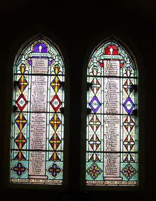
Photograph - Photograph - Colour, Stained Glass Windows in Lydiard Street Uniting Church, Ballarat, 14/02/2009
Two colour photographs of World War One memorial stained glass windows in the Lydiard Street Uniting Church. Three windows are dedicated to those who volunteered for service and returned, the fourth commemorates those who fell. stained glass, lydiard street uniting church, world war one memorial, honour roll, architecture -
 Kilmore Historical Society
Photograph, 11 Sydney Street
15cm x 10cm colour photograph of the Hey Dey Arcade on 11 Sydney Street. There are cars parked at the side of the building which was cream coloured and has burgundy trip. Forrest green hand rails are around the deck. storefronts, cafes -
 Kilmore Historical Society
Photograph, 27 Sydney Street
13cm x 20.5cm black and white photograph of the State Bank at 27 Sydney Street. It is a medium coloured brick double story building. There is traffic lights out the front the building. There is also a clock hanging from the building.banks, banks and banking