Showing 1987 items
matching burke%20museum
-
 Bendigo Historical Society Inc.
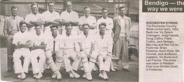
Newspaper - JENNY FOLEY COLLECTION: ROCHESTER'S PRIDE
Bendigo Advertiser "The way we were" from Monday, August 2, 2004. Rochester's pride: the Rochester Country week cricket team, 1952. Back row: Vic Spiers (manager), Greg Francis, Doug Collins, Frank Collins, Jack Neilsen, Mac Hay and Rex Turner. Front row: Brian Florence, Norm Ryan, Bill Connell, Jack Anderson (captain), Vin Burke and Leo Francis. The photo was taken at Western Oval (now Whitten Oval) in Footscray.newspaper, bendigo advertiser, the way we were -
 Kew Historical Society Inc
Plan - Subdivision Plan, Shop Sites, East Kew, c.1927
Subdivision plans are historically important documents used as evidence of the growth of suburbs in Australia. They frequently provide information about when the land was sold on which a built structure was subsequently constructed as well as evidence relating to surveyors and real estate and financial agents. The numerous subdivision plans in the Kew Historical Society's collection represent working documents, ranging from the initial sketches made in planning a subdivision to printed plans on which auctioneers or agents listed the prices for which individual lots were sold. In a number of cases, the reverse of a subdivision plan in the collection includes a photograph of a house that was also for sale by the agent. These photographs provide significant heritage information relating house design and decoration, fencing and household gardens.This is one of a small number of subdivision plans for commercial property in the collection. The subdivision proposed to create six shop sites in High Street between the Harp of Erin and Station Street. The plan shows this stretch of High Street, East Kew already lined with shops that include the hotel on the corner, the new State Savings Bank, a dentist’s surgery and Lambert’s Store. The High Street Tram was to reach Burke Road in 1925, so the proposed subdivision must postdate that event, and the opening of the Bank in 1926.subdivision plans - east kew, high street - east kew -
 Kew Historical Society Inc
Plan - Subdivision Plan, Mont Victor Hill Estate, 1936
Pru Sanderson, in her groundbreaking ‘City of Kew Urban Conservation Study : Volume 2 - Development History’ (1988), summarised the periods of urban development and subdivisions of land in Kew. The periods that she identified included 1845-1880, 1880-1893, 1893-1921, 1921-1933, 1933-1943, and Post-War Development. These periods were selected as they represented periods of rapid growth or decline in urban development. An obvious starting point for Sanderson’s groupings involved population growth and the associated economic cycles. These cycles also highlighted urban expansion onto land that was predominantly rural, although in other cases it represented the decline and breakup of large estates. A number of the plans in the Kew Historical Society’s collection can also be found in other collections, such as those of the State Library of Victoria and the Boroondara Library Service. A number are however unique to the collection.Subdivision plans are historically important documents used as evidence of the growth of suburbs in Australia. They frequently provide information about when the land was sold on which a built structure was subsequently constructed as well as evidence relating to surveyors and real estate and financial agents. The numerous subdivision plans in the Kew Historical Society's collection represent working documents, ranging from the initial sketches made in planning a subdivision to printed plans on which auctioneers or agents listed the prices for which individual lots were sold. In a number of cases, the reverse of a subdivision plan in the collection includes a photograph of a house that was also for sale by the agent. These photographs provide significant heritage information relating house design and decoration, fencing and household gardens.A preliminary plan for the Mont Victor Hill subdivision of 1936 which included 23 allotments bordering the Rimington Nursery in Mont Victor Road. The subdivision created allotments in Victor Avenue, Heather Grove and Burke Road. Bisecting the Estate and clearly marked on the plan is the Railway Reserve which at this stage was all that remained of the Outer Circle Railway. The auctioneers note on the plan that the subdivision was made possible by the order of Messrs S. H. Bennet & H. Wright, the executors of the Wills of S. Bennett & E. Foreman.mont victor hill estate, subdivision plans - kew -
 Kew Historical Society Inc
Map, MMBW, MMBW Plan No.66 Kew, 1900-1910
The Melbourne and Metropolitan Board of Works (MMBW) was established by an act of the Victorian Parliament in 1890 to prepare for and to implement a sewerage and water reticulation system across what was then inner Melbourne, its surrounding and middle distance suburbs, including Kew. The MMBW was disbanded in 1991.The map collection of the Kew Historical Society has at its core the historic maps assembled and originally stored in the City Engineer's Department of the City of Kew. These include maps in a number of scales. The vast majority of maps were produced by the MMBW in the first two decades of the twentieth century, and are solid working maps, backed by linen for durability. These maps are historically significant to Kew, the City of Boroondara and to the history of the development of state utilities in Victoria. A number of the Kew maps have additional details added by former municipal officers, including the levels reached by various floods. As these were working documents, information was added to them long after the period of their initial production and distribution.Early map of part of the Borough of Kew, created in the first decade of the twentieth century, at a scale 160 ft to 1 inch. The map covers what was then the south eastern part of Kew, bordered on its north by Adeney Avenue, in the west by Sackville Street, in the south by Barkers Road, and in the east by Burke Road. The map shows the extent of urban development by that time, prominent institutions and the outlines of built structures in the municipality. Contour lines were added in ink to the map at a later stage.MELBOURNE AND METROPOLITAN BOARD OF WORKS / PLAN NO. 66 / KEW melbourne & metropolitan board of works, mmbw maps, mmbw plans, borough of kew, cartography -
 Melbourne Tram Museum
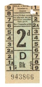
Ephemera - Ticket, Melbourne & Metropolitan Tramways Board (MMTB), MMTB 2d ticket, c1950
MMTB 2d ticket - black printing on green ink, 9 sections, punched for section 1A, ticket number D, Bk, 943866. Has a Bushels tea advertisement on rear. The donor advised that it was probably 1940's/1950's when went to school by tram Whitehorse Road, between Burke Rand Balwyn Road, though the ticket has been punched for a inner section. See Reg Item 3915 for a similar ticket with a Fisher's Wax advert on rear.trams, tramways, tickets, mmtb, advertisements -
 Bendigo Military Museum
Photograph - Photo Troop, Lithographic Squadron – Army Survey Regiment, Fortuna, Bendigo, c1983
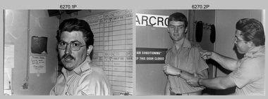
This collection of seven photos was most likely taken at Lithographic Squadron, Army Survey Regiment, Fortuna, Bendigo in c1983. The main tasks undertaken by technicians in Photo Troop were most likely enlargements, reductions and duplication of map reproduction material, and processing of aerial photography.This is a set of seven photographs of Photo Troop personnel and equipment from Lithographic Squadron at the Army Survey Regiment, Fortuna, Bendigo, c1983. The photographs were on 35mm negative film and were scanned at 96 dpi. They are part of the Army Survey Regiment’s Collection. .1) - Photo, black & white, c1983, Photo Troop work area, SGT Garran Hill. .2) - Photo, black & white, c1983, Photo Troop work area, L to R: SPR Steve Burke, SGT Garran Hill. .3) - Photo, black & white, c1983, Photo Troop work area, SPR Steve Burke. .4) - Photo, black & white, c1983, Photo Troop work area, WO1 Noel ‘Nesty’ Coulthard. .5) - Photo, black & white, c1983, Photo Troop work area, WO1 Noel ‘Nesty’ Coulthard. .6) - Photo, black & white, c1983, Photo Troop work area, CPL Gary Tremain. .7) - Photo, black & white, c1983, Photo Troop work area, CPL Neville Carr. No personnel are identified.royal australian survey corps, rasvy, army survey regiment, army svy regt, fortuna, asr, litho -
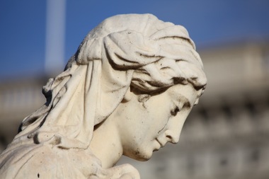
 The Beechworth Burke Museum
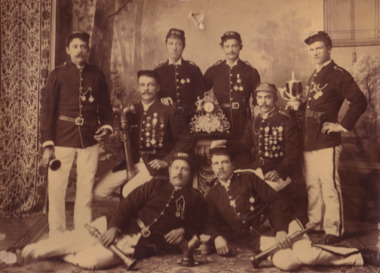
Photograph, Macrh 1892
This photograph depicts the winners of trophies for the eight men hose and ladder and Y coupling events in Ballarat, March 1892. The individuals represented are from let to right J..Keane. / R.Spencer / R. Clements / G.Davis / F.Lloyd (captain) / H.Duncan /G.Weetman / R.Ballantyne, all wearing dress uniforms and holding nozzles and trophies. The clock pictured is this photograph is currently on display in the Falck Street of Shops display in the Burke Museum.Sepia rectangular photograph printed on matte photographic paper and mounted on boardObverse: Beechworth Fire Brigade / Winners of trophies for eight men hose and ladder and y coupling events / Ballarat, March 10th, 1892 / J..Keane. / R.Spencer / G.Davis . F.Lloyd (captain) / H.Duncan / G.Weetman / R.Ballantyneburke museum, fire brigade, sepia, photograph, emergency services, trophy, ballarat -
 City of Ballarat
Sculpture - Public Artwork, Ruth by Charles F. Summers, 1899
Statue of Ruth is a religious reference to the harvest and to the importance of motherhood. Ruth was sculpted by Charles Summers a central figure in Australian art from the mid 19th Century. Summers was a founder of the Victorian Society of Fine Arts in 1856 and in 1863 he became a member of the commission of inquiry into the promotion of the fine arts in Victoria. He created many portraits and busts and is known for his bronze depiction of Burke and Wills in MelbourneThe sculpture is of historic and aesthetic significance to the people of BallaratMarble sculptural depiction of the biblical figure RuthPresented to the City of Ballaarat by the following citizens./ H F Elliot Mayor/ The Hon E Morey MLC/ Cr C B Retallack/ Cr J Heinz/ Cr C C Shoppee/ J N Wilson/ T Stoddart/ ruth, harvest -
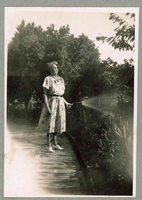 Melbourne Legacy
Photograph, Holmbush Matron, 194X
Photo of the Matron that lived at Holmbush in the 1940s. It is believed to be Dorothy Farmer. From a photo album which contains photos of Holmbush and some of the excursions and events that happened there, appears to have been put together in the 1940s. Including trips to the zoo and picnics. Holmbush at 1267 Burke road, was one of the properties that Legacy used for Junior Legatees. It was purchased 1942. In 1957 Holmbush was renamed Blamey House until it was sold in 1977.A compilation of photos of the matron and junior legatees in the Legacy residences.Black and white photo of Matron watering the garden at Holmbush pasted to the page of an album.residences, holmbush, matron -
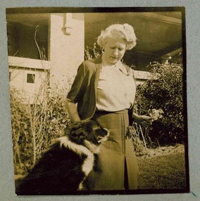 Melbourne Legacy
Photograph, Holmbush Matron, 194X
Photo of the Matron that lived at Holmbush in the 1940s. It is believed to be Dorothy Farmer. From a photo album which contains photos of Holmbush and some of the excursions and events that happened there, appears to have been put together in the 1940s. Including trips to the zoo and picnics. Holmbush at 1267 Burke road, was one of the properties that Legacy used for Junior Legatees. It was purchased 1942, in 1957 Holmbush was renamed Blamey House until it was sold in 1977.A compilation of photos of the matron and junior legatees in the Legacy residences.Black and white photo of Matron and her dog in the garden at Holmbush pasted to the page of an album.residences, holmbush, matron -
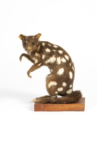
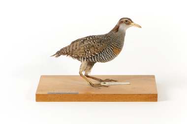 The Beechworth Burke Museum
Animal specimen - Buff-Banded Rail, 1860-1880
The Buff-banded Rail is located on mainland Australia. It can also be found in south-east Asia, New Guinea and New Zealand. These birds are often seen individually or in pairs walking through the dense reeds and vegetations of wetlands or crops. This rail has a slow walk and often flicks its tail, which is raised, as they move. They are omnivore scavengers who feed on a large variety of invertebrates, fruit, seeds and vegetables. This specimen is part of a collection of almost 200 animal specimens that were originally acquired as skins from various institutions across Australia, including the Australian Museum and the National Museum of Victoria, as well as individuals such amateur anthropologist Reynell Eveleigh Johns between 1860-1880. These skins were then mounted by members of the Burke Museum Committee and put-on display in the formal space of the Museum’s original exhibition hall where they continue to be on display. This display of taxidermy mounts initially served to instruct visitors to the Burke Museum of the natural world around them, today it serves as an insight into the collecting habits of the 19th century. This specimen is part of a significant and rare taxidermy mount collection in the Burke Museum. This collection is scientifically and culturally important for reminding us of how science continues to shape our understanding of the modern world. They demonstrate a capacity to hold evidence of how Australia’s fauna history existed in the past and are potentially important for future environmental research. This collection continues to be on display in the Museum and has become a key part to interpreting the collecting habits of the 19th century.This specimen is in a standing position on a wooden platform. The Buff-Branded Rail has a pale grey/yellow eyebrow over the black glass eyes and a pale yellow bill. It also has an orange and brown coloured band on its breast. This bird is multicoloured with streaks of chestnut brown, black, white and a faint orange-brown. This specimen has a paper tag tied to its right leg and a grey/back label on the wooden platform.Platform: "Banded Landrail" Paper tag: "National Museum Victoria. Banded Landrail Hypotoenidia w8 427 Philippensis (L)"taxidermy mount, taxidermy, animalia, burke museum, beechworth, australian museum, skin, reynell eveleigh johns, bird, landrail, buff-banded rail -
 The Beechworth Burke Museum
Animal specimen - Quoll, Trustees of the Australian Museum, 1860-1880
Four species of quoll occur in Australia: the northern, spotted-tailed, eastern and western quolls. Once, most parts of Australia were inhabited by at least one of the species.Captain Cook collected quolls along the east coast in 1770, and recorded "quoll" as their local Aboriginal name. Quolls were often seen by early settlers, who called them "native cat", "native polecat" and "spotted marten", names based on familiar European animals. Since 1770, all four species have declined dramatically in numbers. This is mainly because of habitat loss or change across Australia, and introduced predators such as foxes and cats. Quolls are carnivorous marsupials with a pointed snout, a long tail and brown to black fur distinctively spotted with white. They are lively, attractive animals, with bright eyes, a moist pink nose and many sharp teeth. Like most Australian mammals, quolls are mainly active at night. Typically, they spend the day in one of their many dens, although spotted-tailed quolls and northern quolls sometimes forage and bask in the sunshine. Their large home ranges can extend for several kilometres in each direction from a smaller core range, and the range of a male quoll often overlaps those of several females. An interesting feature of their behaviour is the use of shared latrine (toilet) sites in open spaces such as rock ledges, for marking their territory and other social functions. Male quolls travel widely during the breeding season, with mating occurring during winter. All four species have a gestation period of 21 days. Because they are marsupial mammals, their young are born tiny and undeveloped and must work their way to the pouch, where they attach themselves to a teat to feed. Only the spotted-tailed quoll has a true pouch. In the other species, the young are protected by shallow folds of skin around the teats. As the pups grow, they dangle from the mother's belly; later, she carries them on her back. Quolls reach sexual maturity at one year. They have a naturally short life span, with smaller quolls living an average of only two years, and the larger spotted-tailed quoll about four to five years. The northern quoll is particularly short-lived. This specimen is part of a collection of almost 200 animal specimens that were originally acquired as skins from various institutions across Australia, including the Australian Museum and the National Museum of Victoria, as well as individuals such amateur anthropologist Reynell Eveleigh Johns between 1860-1880. These skins were then mounted by members of the Burke Museum Committee and put-on display in the formal space of the Museum’s original exhibition hall where they continue to be on display. This display of taxidermy mounts initially served to instruct visitors to the Burke Museum of the natural world around them, today it serves as an insight into the collecting habits of the 19th century. This specimen is part of a significant and rare taxidermy mount collection in the Burke Museum. This collection is scientifically and culturally important for reminding us of how science continues to shape our understanding of the modern world. They demonstrate a capacity to hold evidence of how Australia’s fauna history existed in the past and are potentially important for future environmental research. This collection continues to be on display in the Museum and has become a key part to interpreting the collecting habits of the 19th century.Average sized quoll with brown fur with white spots on body but absence on the long tail which is furry unlike the smooth body fur. The quoll has a small had with a pointed snout lined with sharp teeth, and thin membraned ears that are slightly covered in fur. The forelegs of the quoll are slightly smaller than the hindlegs, with all four legs featuring sharp clawed paws.On mounting board: BMM5984/ On Catalogue Tag (attached to left hindleg): Native Cat./ Catalogue. Page 50./ burke museum, taxidermy, taxidermy mount, fauna, animal, animalia, reynell eveleigh johns, quoll, native cat, dasyurus -
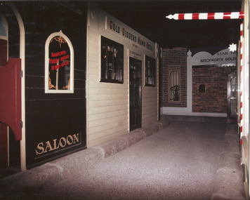 The Beechworth Burke Museum
Photograph, c1990
Taken in the 1990's, this photograph depicts a row of shop fronts in the 'Street of Shops' exhibition in the Burke Museum in Beechworth. This exhibition was created and opened in 1979 and was intended to reflect and imitate a historic peirod in the town's past. The time period decpicted is that of the Gold Rush which swept through many Victorian towns from the 1850's onwards. For the town of Beechworth, the gold rush began in 1852, when gold was discovered in Spring Creek, drawing in many new residents seeking to make a fortune and transforming a once remote town into a bustling centre brimming with hope and opportunity. By 1857, the town contained over 200,000 residents and with this, the need for more amenities and intsitutions arose. Multiple churches, banks, schools, shops, hospitals and other essential buildings appearing over the years. The wealth acquired through the gold rush is largely responsible for the vast development of the town and many of its significant buildings which still remain to this day. This photograph also highlights the significance of this type of exhibition, providing a new mode of experiencing and learning about the past. The street depicts the many supporting trades and industries that arose from the mass migration during the gold rush. The creation of the Street of Shops in 1979 was envisioned by Roy Harvey who was the curator at the time, with the intention of recreating an authentic feel to the environment while collecting from the community to accurately portray the multiculturalism that is ingrainded in many towns and communities of Victoria. This photograph contains historical significance as it relates to and portrays an especially important period of time within Beechworth and Victoria's history. The gold rush phenomena ushered in a wave of hope and prosperity for citizens and immigrants alike. It provided many with the opportunity to strike it rich, while the town prospered and grew in many ways. This widespread development that accompanied the gold rush occured throughout Victoria and holds great historical importance when recording the social, economic and communal developments that occured throughout the time period which gave way to the beloved towns and communities we know today. Beechworth itself is acknowledged as Victoria's best-preserved gold mining town and deserves recognition of its significance. it also showcases the great significance of social develpment and globalization that occured throughout the state during this period. Coloured rectangular photograph printed on matte photographic paper and unmounted. Obverse: Dancing every night 8pm-6am [mirror] / Gold Diggers Arms Hotel façade / Star / Beechworth Gold / J. Davidson / Saloon Reverse: 3306 beechworth, burke museum, street of shops, gold rush, indigo shire gold rush, 1850s beechworth, burke museum exhibitions, saloon, gold buyer, hotel, historical streetscape, gold rush immigration -
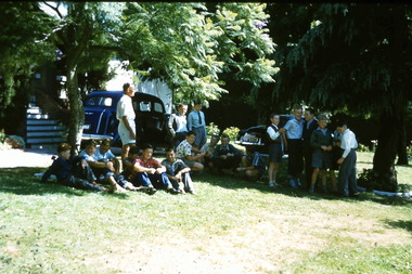 Melbourne Legacy
Slide, Holiday Camp 1958. Boys relax at Blamey House, 1958
A colour slides of boys in the garden of Blamey House, Burke Rd, during a summer holiday camp in 1958. Blamey House was used for camps over summer holidays for many years. Was with many other slides taken in the 1950s and 1960s. The slides have been photographed to make digital images and moved to archive quality sleeves. In many cases the original images were not well focussed and the digital image the best available.A record of camps being organised for children.Colour slide photo of a group of boys in a garden at Blamey House in a cardboard Kodachrome mount.Handwritten on front 'Boys relax at Blamey House' and '1958' in blue pen. Imprinted '12' in black ink. Printed on reverse 'Kodachrome Transparency / Processed by Kodak' with a red outline on edge of slide. Handwritten on reverse 'Boys at Blamey / 3 / SET 2' in pen.camps, blamey house -
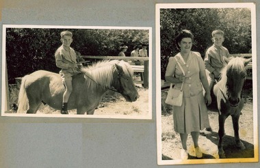 Melbourne Legacy
Photograph, Holmbush boy on a horse, 194X
Photo of a boy that lived at Holmbush sitting on a horse, in one photo he is accompanied by a lady. The lady could be another resident of Holmbush or it could be his mother or relative taking him on a special outing. The names are not known. He is seen in other photos in the album. Holmbush at 1267 Burke road, was one of the properties that Legacy used for Junior Legatees. It was purchased 1942. In 1957 Holmbush was renamed Blamey House until it was sold in 1977.A compilation of photos of some junior legatees in the Legacy residences.Black and white photo x 2 of a boy from Holmbush sitting on a horse pasted to the pages of an album.residences, holmbush, junior legatees -
 Melbourne Legacy
Photograph, Holmbush residents, 194X
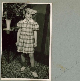
Photo of a boy who lived at Holmbush, the inscription next to the photo says Billy Tennant. He is dressed up in a girls dress and hat. The photo was published with others in the September 1949 newsletter with an article saying there was a fancy dress ball at Holmbush on 20th August. Holmbush at 1267 Burke road, was one of the properties that Legacy used for Junior Legatees. It was purchased 1942, in 1957 Holmbush was renamed Blamey House until it was sold in 1977.A compilation of photos of some junior legatees in the Legacy residences.Black and white photo of a boy dressed in a dress at Holmbush pasted to the pages of an album.residences, holmbush, junior legatees -
 Melbourne Tram Museum
Postcard - Shrine of Remembrance, St Kilda Road and W class trams, Australia Post, 1990
Postcard - an image of Shrine of Remembrance, St Kilda Road with three W class trams in the view. The postcard has had postage including international or worldwide prepaid. The stamp is 65c, the ANZAC tradition. The reference gives the date of the stamp as April 1990. Two of the trams: SW6 918 (Malvern Burke Road, Route 5), and SW6 944 (Toorak Glenferrie Road, Route 8). Another W class tram is behind.Demonstrates an iconic Melbourne image, the Shrine of Remembrance and W class trams in St Kilda Road.Postcard colour - Shrine of Remembrance, St Kilda Road and W class trams - with pre paid postage. Australia Posttrams, tramways, st kilda road, sw6 class trams, tram 918, tram 944, australia post, shrine of remembrance -
 Disability Sport & Recreation Victoria
Newsletter, Paravics Newsletter Vol. 1 No. 12, May 1972 - Paraplegic and Quadriplegic Association of Victoria, May 1971
The Paravics Sports Club, now known as Disability Sport and Recreation Victoria, was formed in 1962 to help a group of eight athletes with disability compete in national and international sporting competitions. Apart from its goal for advocating for greater sporting and recreation opportunities for disabled athletes, Paravics / Paraplegic and Quadriplegic Association of Victoria also sought to bring awareness and advocacy to the general needs of wheelchair bound persons. The newsletter, the first for 1972, includes numerous news items, including: - Notes from Dr Burke of the Austin Hospital's Spinal Unit, on a year-long of tour of overseas spinal centres, principally in South Africa, France, United Kingdom, and the United States. Burke notes that based on his observations during tour, the standard and quality of treatment at the Austin for spinal injuries is "As good as anywhere in the world and in some respects the best, particularly that of early treatment after injury". Burke also notes the difference in attitudes between different countries in terms of research focus, equipment and technology, the use of sport as a rehabilitation tool for people with permanent spinal injuries, and staffing levels and education. - Job vacancies - News from the Quadriplegic Activities Group. - Information about various auxiliary groups and fundraising efforts. - News about members of the organisation. - A letter from Mrs D. Kendall about her efforts to improve the situation for disabled car drivers with regards to parking, and for providing wheelchairs to various venues for the purposes of providing access to such places as the Myer Music Bowl, parks, gardens, etc With the introduction of the metric system in Australia, Paravics attempted to use the adoption of the metric system for a fundraising campaign called "mark a metre", which included a poster attached to the newsletter.Three photocopied sheets (6 pages, double-sided), full-text.This newsletter contains six pages of news items.paravics sports club, disabled sports, wheelchair sport, mike jarrett, paraplegic and quadriplegic association of victoria -
 Bendigo Historical Society Inc.
Document - ANCIENT ORDER OF FORESTERS NO. 3770 COLLECTION: CORRESPONDENCE
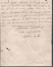
Letter written on white paper to the Chief Ranger, Court King of the Forest from Matthew Burke and dated January 31/1872. Matthew had been accused of being illegally on the Court funds. He wrote the letter saying he was being treated by the doctor. The doctor told him to go on the funds as he was not fit for work. He also says he has never been bad on the books yet. Court King of the Forest A.O.F. No. 3770 Sandhurst impression stamp at the top of the letter.societies, aof, correspondence, ancient order of foresters no. 3770 collection - correspondence, court king of the forest, matthew burke -
 Bendigo Historical Society Inc.
Postcard - WES HARRY COLLECTION: 7 POSTCARDS, 1904 - 08
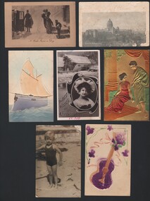
Seven assorted postcards addressed to Mrs. A. Stephens and having various themes. (a) Christmas theme card depicting a water wheel and the actress Billie Burke., (b) embossed card with an guitar and flower theme., (c) Card with a faded photograph of the Exhibition Buildings , Melbourne., (d) Cartoon with The caption ' I wish I was a dog ' (e) Embossed card with a classical Roman or Greek theme., (f) embossed card depicting a sailing ship., (g) Photograph of a child, 5 or 6 years old , in a bathing costume.postcard, various themes, water wheel , billie burke, guitar, exhibition buildings , melbourne, i wish i was a dog, roman theme, sailing ship, boy in bathing costume -
Bendigo Historical Society Inc.
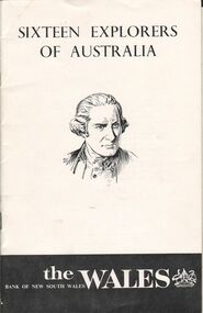
Book - SIXTEEN EXPLORERS OF AUSTRALIA, Feb. 1977
Booklet. 17 page booklet giving one-page stories of exploration of Australia with drawings and maps. Explorers are Abel Tasman, James Cook, George Bass, Matthew Flinders, Gregory Blaxland, John Oxley, Phillip Parker King, Charles Sturt, Thomas Mitchell, Edward Eyre, Ludwig Leichhardt, Augustus Charles Gregory, Edmund Kennedy, Robert O'Hara Burke, John McDouall Stuart, John Forrest. Published by the Bank of NSW and printed by Sydney Allen Printers P/L, Rydalmere, NSW.Bank of NSWhistory, australian, australian explorers, history. -
 Bendigo Historical Society Inc.
Book - AILEEN AND JOHN ELLISON COLLECTION: SIXTEEN EXPLORERS OF AUSTRALIA
Small booklet: Sixteen Explorers of Australia. A portrait of Captain Cook on the front page. It was published in March 1965 by the Bank of New South Wales. The booklet has 17 pages. Contents: Preface - Abel Tasman - James Cook - George Bass - Matthew Flinders - Gregory Blaxland - John Oxley - Phillip Parker King - Charles Sturt - Thomas Livingstone Mitchell - Edward John Eyre - Ludwig Leichardt - Augustus Charles Gregory - Edmund Kennedy - Robert O'Hara Burke - John McDouall Stuart - John Forrest.books, biography, explorers of australia -
 Ballarat Tramway Museum
Slide - 35mm slide/s, Keith Caldwell, 12/03/1962 12:00:00 AM
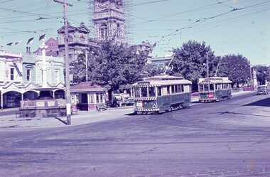
Yields information about the nature of tram services at the city terminus at Sturt and Lydiard St and the street scene at the time.Agfa colour slide, white cardboard mount, photo by Keith Caldwell on 12/3/1962 of: Trams 11 and 27 arriving at the "Tramway Centre" the city terminus. Tram 11 has the destination of Mt Pleasant and has a The Age dash canopy advertisement. No. 27 showing Victoria St and has a Briquettes dash panel advertisement. In the background is the Burke and Wills Fountain, shelter, Golden Star Chinese Cafe, Georges Sea Food shop and the Town Hall with the clock tower having scaffolding around it.In ink "Ballarat 12.3.62"tramways, trams, shelters, sturt st, lydiard st north, fountains, tram 11, tram 27 -
Bendigo Historical Society Inc.
Book - Gold and Silver, Photographs of Australian Goldfields from the Holtermann Collection, 1973
Soft cover book of 263 pages by Keast Burke. Gold and Silver, Photographs of Australian Goldfields from the Holtermann Collection. B&W photo of the top of a mine shaft on front cover. Includes biographical portraits of Bernard Otto Holtermann, Beaufoy Merlin and Charles Bayliss. Photos mainly of Hill End and Gulgong, NSW. Penguin Books Ltd, first published by William Heinemann, Australia Pty Ltd 1973 Designed by David Wire and printed by Alexander Brothers Pty Ltd, Mentone, Victoria.gold mining, hill end, gulgong -
Kew Historical Society Inc
Plan - Tramway Estate, Camberwell North, 1937
Subdivision plans and real estate flyers/brochures reveal a number of aspects of urban development and history. The Kew Historical Society's collection of these plans, as well as advertisements extracted from magazines, cover key aspects of community development and architectural history of Kew and Kew Eat as well as surrounding suburbs. While most of the plans in the collection were gifted to the Society by the former City of Kew, a number of other plans and advertisements have been donated by individuals, of which this is an example.Single page subdivision plan listing properties for sale in the Tramways Estate, Camberwell North. The large estate was bounded by Doncaster Road, Burke Road, Marwan Avenue, Maud Street, Severn Street, and extended over Glass's Creek at Mayland's Avenue. Within the plan, lots 3 to 342 are listed as lots. The plan includes annotations in ink indicating the prices realised by a number of lots. A key explains that lots with an 'H' represent a house, whereas the 37 shaded lots represent those being offered by this agent. subdivision plans -- camberwell (vic.), tramways estate -
 Kew Historical Society Inc
Plan - Subdivision Plan, St Helliers Estate, Kew, circa 1910, c.1910
Pru Sanderson, in her groundbreaking ‘City of Kew Urban Conservation Study : Volume 2 - Development History’ (1988), summarised the periods of urban development and subdivisions of land in Kew. The periods that she identified included 1845-1880, 1880-1893, 1893-1921, 1921-1933, 1933-1943, and Post-War Development. These periods were selected as they represented periods of rapid growth or decline in urban development. An obvious starting point for Sanderson’s groupings involved population growth and the associated economic cycles. These cycles also highlighted urban expansion onto land that was predominantly rural, although in other cases it represented the decline and breakup of large estates. A number of the plans in the Kew Historical Society’s collection can also be found in other collections, such as those of the State Library of Victoria and the Boroondara Library Service. A number are however unique to the collection.Subdivision plans are historically important documents used as evidence of the growth of suburbs in Australia. They frequently provide information about when the land was sold on which a built structure was subsequently constructed as well as evidence relating to surveyors and real estate and financial agents. The numerous subdivision plans in the Kew Historical Society's collection represent working documents, ranging from the initial sketches made in planning a subdivision to printed plans on which auctioneers or agents listed the prices for which individual lots were sold. In a number of cases, the reverse of a subdivision plan in the collection includes a photograph of a house that was also for sale by the agent. These photographs provide significant heritage information relating house design and decoration, fencing and household gardens.In the subdivision of part of Crown Portion 82, bordered by John and Sackville Streets and Cotham and Burke Roads, over 100 lots were offered for sale. In addition to the designated lots, a number of key locations are also identified. These include the Genazzano Convent to the north of Cotham Road, the Reservoir, St Hilary’s and the land holding of Colonel Parnell on the corner of John Street and Cotham Road. On the Plan, No. 5064, is the handwritten name ‘St. Hellier’s Estate’. St. Helliers, the home of the Dumaresq family is shown beside St. Hilary’s.subdivision plans - kew, st helliers estate -
 Kew Historical Society Inc
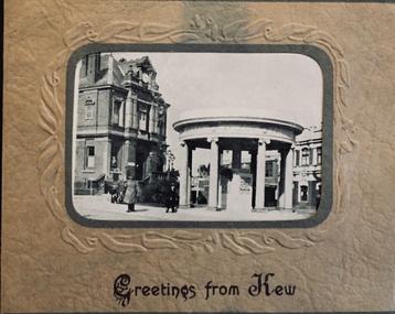
Postcard, Greetings from Kew, c.1928
An item from an outstanding and diverse photographic collection, assembled by members of the Christian and Washfold families of Kew.Rae series of postcards, otherwise unknown, showing important sites in KewSmall folding postcard including nine black and white postcard views of Kew. Cover depicts Kew War Memorial set within an embossed cardboard frame. Individual postcards include: Studley Park Road, River Yarra showing new Bridge [Chandler Hwy], High Street showing soldier's memorial, River Yarra at Victoria Bridge, The Yarra at Studley Park, Holy Trinity Church, the [Alexandra] Gardens, New Yarra Bridge [Burke Rd], Soldiers' Memorial and Post Office Kewwashfold family, christian-washfold collection, postcards -- kew (vic.) -
 Kew Historical Society Inc
Map, MMBW, MMBW Plan No.68 Kew, 1900-1910
The Melbourne and Metropolitan Board of Works (MMBW) was established by an act of the Victorian Parliament in 1890 to prepare for and to implement a sewerage and water reticulation system across what was then inner Melbourne, its surrounding and middle distance suburbs, including Kew. The MMBW was disbanded in 1991.The map collection of the Kew Historical Society has at its core the historic maps assembled and originally stored in the City Engineer's Department of the City of Kew. These include maps in a number of scales. The vast majority of maps were produced by the MMBW in the first two decades of the twentieth century, and are solid working maps, backed by linen for durability. These maps are historically significant to Kew, the City of Boroondara and to the history of the development of state utilities in Victoria. A number of the Kew maps have additional details added by former municipal officers, including the levels reached by various floods. As these were working documents, information was added to them long after the period of their initial production and distribution.Early map of part of the Borough of Kew, created in the first decade of the twentieth century, at a scale 160 ft to 1 inch. The map covers what was then the north central part of Kew, bordered in the north by Oak Avenue, in the west by the Yarra River and Connor's Creek, in the south by Beresford and Carnegie Avenues, and in the east by Glass's Creek and Burke Road. The map shows the extent of urban development by that time, prominent institutions and the outlines of built structures in the municipality. Contour lines and the levels of historic floods were added in ink to the map at a later stage.MELBOURNE AND METROPOLITAN BOARD OF WORKS / PLAN NO. 68 / KEW melbourne & metropolitan board of works, mmbw maps, mmbw plans, borough of kew, cartography -
 Melbourne Tram Museum
Document - Instruction, Yarra Trams, "W class Safety Alert - Fail Safe Park Brake", "Malvern Terminal Procedures", 24/03/2006 12:00:00 AM
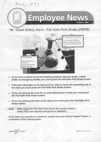
.1 - single A4 sheet - titled "W class Safety Alert - Fail Safe Park Brake", dated 24/3/2006, detailing procedures for the use of the parking braking system fitted to W class tramcars. Includes a photograph of the button. .2 - Instruction - from Staff Induction Manual, detailing terminus procedures for Malvern Depot; University terminus, Malvern Burke Road, Glen Iris, Camberwell and Kew terminus for Z and Combino trams .3 - as above, but includes Luna Park terminus.1 - Has "Ron, FYI" in ink on the top left hand corner.trams, tramways, w class, braking, instructions, malvern depot, university, burke rd, glen iris, kew, luna park, camberwell -
 Melbourne Tram Museum
Slide, Keith Caldwell, June 1971?
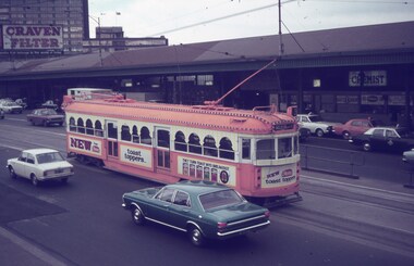
Agfa colour slide, blue and white plastic mount, photo by Keith Caldwell possibly June 1971? of W7 1024 in all over advertising for Heinz Toast Toppers. Tram passing Flinders St station in Swanston St with the destination of Malvern Burke Road, route 3. In the view is an advertisement for Craven Filter cigarettes. Based on VicSig article on advertising trams - see http://vicsig.net/index.php?page=trams&article=adtrams accessed 9/9/2019, the date would be June 1971.trams, tramways, flinders st station, swanston st, advertising trams, malvern, route 3, tram 1024