Showing 862 items
matching easy-meel
-
 National Wool Museum
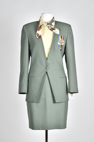
Uniform - Jacket, Wendy Powitt, 1992 Barcelona Olympic Games Official Occasions Womans's Jacket, c1992
About the 1992 Barcelona Olympic Games donator Doug Pleasance wrote- During the 1980s the Australian wool industry was at its most prosperous times with record numbers of sheep producing wool receiving ever increasing values due to the success of the Reserve Price Scheme, and the overall guidance of the Australian Wool Corporation (AWC). As a humble technichian, my role was a low profile newly created position of “Controller, Technical Marketing” where wool was to be marketed on its technical properties, as distinct from the “Product Marketing Group” which exploited trhe traditional high profile approach of marketing wool;s superior fashion attributes. The Woolmark was the tool central to this approach. The 1992 Barcelona Olympic Games saw an evolutionary change in designer selection. A Declaration of Interest Form was communicated to over forty potential designers. The task and especially tight timelines that were involved deterred many aspirants, however, there remained eight designers with the potential we were seeking. These eight designers were paid $3,000 per submission and the winning designer, Wendy Powitt, was paid $15,000. For the first time the judging panel included two athletes, one male swimmer and one female basketballer, their influence was pivotal. The ensemble consisted of three elements- 1. The Official Uniform which was used for travel and all official functions. This included: a tailored blazer and trouser/skirt (all water repellent) by Fletcher Jones, pure wool olive-green faille fabric by Foster Valley, cotton PE formal shirt by Pelaco, pure wool knitwear by Spangaro, printed wool tie by TD Noone, wool nylon socks by Holeproof and footwear by Hush Puppy. 2. Opening Ceremony Uniform a lightweight wool fabric printed with floral designs that had been inspired by the work of Australian artist Margaret Preston. This included: Lightweight W/PE shorts by Fletcher Jones in Foster Valley Fabric, socks by Holeproof and footwear by Hush Puppy. 3. Village Clothing was designed to be highly visible garments to make it easy to ‘spot the Aussie’ and helped to contribute to good team spirit. This included: A pure wool shirt featuring blocks of contrasting colours, and a newly developed stretch 50:50 wool/cotton fabric by Bradmill was made into shorts and jeans by Fletcher Jones.Green button up tailored jacket with two faux pockets and a breast pocket on left hand side. Olympic logo on left breast pocket.Label 1 - Barcelona 1992 Official Uniform Supplied by Australian Wool Corporation Label 2 - Fletcher Jones Australia On breast of jacket - Australia Barcelona 19921992 barcelona olympics, uniform, jacket, fletcher jones -
 National Wool Museum
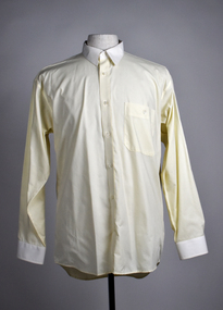
Uniform - Shirt, Wendy Powitt, 1992 Barcelona Olympic Games Official Occasions Male Shirt, c.1992
About the 1992 Barcelona Olympic Games donator Doug Pleasance wrote- During the 1980s the Australian wool industry was at its most prosperous times with record numbers of sheep producing wool receiving ever increasing values due to the success of the Reserve Price Scheme, and the overall guidance of the Australian Wool Corporation (AWC). As a humble technichian, my role was a low profile newly created position of “Controller, Technical Marketing” where wool was to be marketed on its technical properties, as distinct from the “Product Marketing Group” which exploited trhe traditional high profile approach of marketing wool;s superior fashion attributes. The Woolmark was the tool central to this approach. The 1992 Barcelona Olympic Games saw an evolutionary change in designer selection. A Declaration of Interest Form was communicated to over forty potential designers. The task and especially tight timelines that were involved deterred many aspirants, however, there remained eight designers with the potential we were seeking. These eight designers were paid $3,000 per submission and the winning designer, Wendy Powitt, was paid $15,000. For the first time the judging panel included two athletes, one male swimmer and one female basketballer, their influence was pivotal. The ensemble consisted of three elements- 1. The Official Uniform which was used for travel and all official functions. This included: a tailored blazer and trouser/skirt (all water repellent) by Fletcher Jones, pure wool olive-green faille fabric by Foster Valley, cotton PE formal shirt by Pelaco, pure wool knitwear by Spangaro, printed wool tie by TD Noone, wool nylon socks by Holeproof and footwear by Hush Puppy. 2. Opening Ceremony Uniform a lightweight wool fabric printed with floral designs that had been inspired by the work of Australian artist Margaret Preston. This included: Lightweight W/PE shorts by Fletcher Jones in Foster Valley Fabric, socks by Holeproof and footwear by Hush Puppy. 3. Village Clothing was designed to be highly visible garments to make it easy to ‘spot the Aussie’ and helped to contribute to good team spirit. This included: A pure wool shirt featuring blocks of contrasting colours, and a newly developed stretch 50:50 wool/cotton fabric by Bradmill was made into shorts and jeans by Fletcher Jones.Yellow shirt, one pocket on left breast. The cuffs and the collar are white.On label - Barcelona 1992 Official Uniform supplied by Australian Wool Corporation1992 barcelona olympics, wool, australian wool corporation -
 National Wool Museum
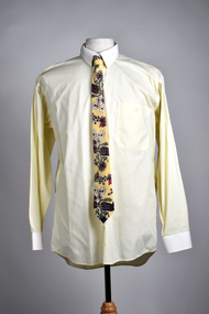
Uniform - Tie, Wendy Powitt, 1992 Barcelona Olympic Games Official Occasions Male Tie, c1992
About the 1992 Barcelona Olympic Games donator Doug Pleasance wrote- During the 1980s the Australian wool industry was at its most prosperous times with record numbers of sheep producing wool receiving ever increasing values due to the success of the Reserve Price Scheme, and the overall guidance of the Australian Wool Corporation (AWC). As a humble technichian, my role was a low profile newly created position of “Controller, Technical Marketing” where wool was to be marketed on its technical properties, as distinct from the “Product Marketing Group” which exploited trhe traditional high profile approach of marketing wool;s superior fashion attributes. The Woolmark was the tool central to this approach. The 1992 Barcelona Olympic Games saw an evolutionary change in designer selection. A Declaration of Interest Form was communicated to over forty potential designers. The task and especially tight timelines that were involved deterred many aspirants, however, there remained eight designers with the potential we were seeking. These eight designers were paid $3,000 per submission and the winning designer, Wendy Powitt, was paid $15,000. For the first time the judging panel included two athletes, one male swimmer and one female basketballer, their influence was pivotal. The ensemble consisted of three elements- 1. The Official Uniform which was used for travel and all official functions. This included: a tailored blazer and trouser/skirt (all water repellent) by Fletcher Jones, pure wool olive-green faille fabric by Foster Valley, cotton PE formal shirt by Pelaco, pure wool knitwear by Spangaro, printed wool tie by TD Noone, wool nylon socks by Holeproof and footwear by Hush Puppy. 2. Opening Ceremony Uniform a lightweight wool fabric printed with floral designs that had been inspired by the work of Australian artist Margaret Preston. This included: Lightweight W/PE shorts by Fletcher Jones in Foster Valley Fabric, socks by Holeproof and footwear by Hush Puppy. 3. Village Clothing was designed to be highly visible garments to make it easy to ‘spot the Aussie’ and helped to contribute to good team spirit. This included: A pure wool shirt featuring blocks of contrasting colours, and a newly developed stretch 50:50 wool/cotton fabric by Bradmill was made into shorts and jeans by Fletcher Jones.Floral tie with cream, red, green native flower design.On label - Woven & manufactured in Australia by "Tee-Dee" exclusively for the Australian Wool Corporation1992 barcelona olympics, uniform, tie, australian wool corporation -
 National Wool Museum
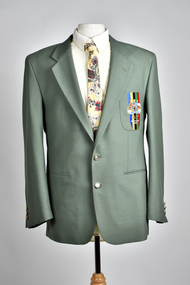
Uniform - Jacket, Wendy Powitt, 1992 Barcelona Olympic Games Official Occasions Male Jacket, c1992
About the 1992 Barcelona Olympic Games donator Doug Pleasance wrote- During the 1980s the Australian wool industry was at its most prosperous times with record numbers of sheep producing wool receiving ever increasing values due to the success of the Reserve Price Scheme, and the overall guidance of the Australian Wool Corporation (AWC). As a humble technichian, my role was a low profile newly created position of “Controller, Technical Marketing” where wool was to be marketed on its technical properties, as distinct from the “Product Marketing Group” which exploited trhe traditional high profile approach of marketing wool;s superior fashion attributes. The Woolmark was the tool central to this approach. The 1992 Barcelona Olympic Games saw an evolutionary change in designer selection. A Declaration of Interest Form was communicated to over forty potential designers. The task and especially tight timelines that were involved deterred many aspirants, however, there remained eight designers with the potential we were seeking. These eight designers were paid $3,000 per submission and the winning designer, Wendy Powitt, was paid $15,000. For the first time the judging panel included two athletes, one male swimmer and one female basketballer, their influence was pivotal. The ensemble consisted of three elements- 1. The Official Uniform which was used for travel and all official functions. This included: a tailored blazer and trouser/skirt (all water repellent) by Fletcher Jones, pure wool olive-green faille fabric by Foster Valley, cotton PE formal shirt by Pelaco, pure wool knitwear by Spangaro, printed wool tie by TD Noone, wool nylon socks by Holeproof and footwear by Hush Puppy. 2. Opening Ceremony Uniform a lightweight wool fabric printed with floral designs that had been inspired by the work of Australian artist Margaret Preston. This included: Lightweight W/PE shorts by Fletcher Jones in Foster Valley Fabric, socks by Holeproof and footwear by Hush Puppy. 3. Village Clothing was designed to be highly visible garments to make it easy to ‘spot the Aussie’ and helped to contribute to good team spirit. This included: A pure wool shirt featuring blocks of contrasting colours, and a newly developed stretch 50:50 wool/cotton fabric by Bradmill was made into shorts and jeans by Fletcher Jones.Green jacket with Olympic emblem on left breast pocketLabel 1 - Barcelona 1992 Official Uniform Supplied by Australian Wool Corporation Label 2 - Fletcher Jones Australia Label 3 - Warm iron dry clean only On jacket breast - Australia Barcelona 19921992 barcelona olympics, uniform, tie, australian wool corporation -
 National Wool Museum
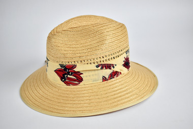
Uniform - 1992 Barcelona Olympic Games Akubra Hat, Akubra, c1992
About the 1992 Barcelona Olympic Games donator Doug Pleasance wrote- During the 1980s the Australian wool industry was at its most prosperous times with record numbers of sheep producing wool receiving ever increasing values due to the success of the Reserve Price Scheme, and the overall guidance of the Australian Wool Corporation (AWC). As a humble technichian, my role was a low profile newly created position of “Controller, Technical Marketing” where wool was to be marketed on its technical properties, as distinct from the “Product Marketing Group” which exploited trhe traditional high profile approach of marketing wool;s superior fashion attributes. The Woolmark was the tool central to this approach. The 1992 Barcelona Olympic Games saw an evolutionary change in designer selection. A Declaration of Interest Form was communicated to over forty potential designers. The task and especially tight timelines that were involved deterred many aspirants, however, there remained eight designers with the potential we were seeking. These eight designers were paid $3,000 per submission and the winning designer, Wendy Powitt, was paid $15,000. For the first time the judging panel included two athletes, one male swimmer and one female basketballer, their influence was pivotal. The ensemble consisted of three elements- 1. The Official Uniform which was used for travel and all official functions. This included: a tailored blazer and trouser/skirt (all water repellent) by Fletcher Jones, pure wool olive-green faille fabric by Foster Valley, cotton PE formal shirt by Pelaco, pure wool knitwear by Spangaro, printed wool tie by TD Noone, wool nylon socks by Holeproof and footwear by Hush Puppy. 2. Opening Ceremony Uniform a lightweight wool fabric printed with floral designs that had been inspired by the work of Australian artist Margaret Preston. This included: Lightweight W/PE shorts by Fletcher Jones in Foster Valley Fabric, socks by Holeproof and footwear by Hush Puppy. 3. Village Clothing was designed to be highly visible garments to make it easy to ‘spot the Aussie’ and helped to contribute to good team spirit. This included: A pure wool shirt featuring blocks of contrasting colours, and a newly developed stretch 50:50 wool/cotton fabric by Bradmill was made into shorts and jeans by Fletcher Jones.Straw hat by brand ‘Akubra’ in the style ‘Olympian’, size 56. Sides of crown woven with decorative pattern and hatband printed with native Australian flora. Retains original swing tag.Labels: Akubra / 56 / Olympian / MADE IN AUSTRALIA1992 barcelona olympics, uniform, australian wool corporation, hat -
 National Wool Museum
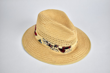
Uniform - 1992 Barcelona Olympic Games Akubra Hat, Akubra, c1992
About the 1992 Barcelona Olympic Games donator Doug Pleasance wrote- During the 1980s the Australian wool industry was at its most prosperous times with record numbers of sheep producing wool receiving ever increasing values due to the success of the Reserve Price Scheme, and the overall guidance of the Australian Wool Corporation (AWC). As a humble technichian, my role was a low profile newly created position of “Controller, Technical Marketing” where wool was to be marketed on its technical properties, as distinct from the “Product Marketing Group” which exploited trhe traditional high profile approach of marketing wool;s superior fashion attributes. The Woolmark was the tool central to this approach. The 1992 Barcelona Olympic Games saw an evolutionary change in designer selection. A Declaration of Interest Form was communicated to over forty potential designers. The task and especially tight timelines that were involved deterred many aspirants, however, there remained eight designers with the potential we were seeking. These eight designers were paid $3,000 per submission and the winning designer, Wendy Powitt, was paid $15,000. For the first time the judging panel included two athletes, one male swimmer and one female basketballer, their influence was pivotal. The ensemble consisted of three elements- 1. The Official Uniform which was used for travel and all official functions. This included: a tailored blazer and trouser/skirt (all water repellent) by Fletcher Jones, pure wool olive-green faille fabric by Foster Valley, cotton PE formal shirt by Pelaco, pure wool knitwear by Spangaro, printed wool tie by TD Noone, wool nylon socks by Holeproof and footwear by Hush Puppy. 2. Opening Ceremony Uniform a lightweight wool fabric printed with floral designs that had been inspired by the work of Australian artist Margaret Preston. This included: Lightweight W/PE shorts by Fletcher Jones in Foster Valley Fabric, socks by Holeproof and footwear by Hush Puppy. 3. Village Clothing was designed to be highly visible garments to make it easy to ‘spot the Aussie’ and helped to contribute to good team spirit. This included: A pure wool shirt featuring blocks of contrasting colours, and a newly developed stretch 50:50 wool/cotton fabric by Bradmill was made into shorts and jeans by Fletcher Jones.Straw hat by brand ‘Akubra’ in the style ‘Olympian’, size 59. Sides of crown woven with decorative pattern and hatband printed with native Australian flora. Labels: Akubra / 59 / Olympian / MADE IN AUSTRALIA1992 barcelona olympics, uniform, australian wool corporation, hat -
 Parks Victoria - Point Hicks Lightstation
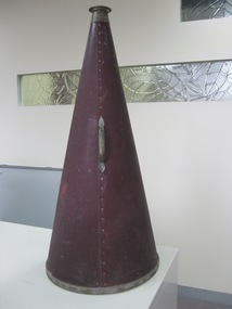
Megaphone
Used to communicate with ships from Point Hicks Lightstation. In Greek mythology, "Stentor" was a herald on the Greek side during the Trojan War. His name has given rise to the adjective "stentorian", meaning loud-voiced, for which he was famous. Homer said his "voice was as powerful as fifty voices of other men." He died after his defeat by Hermes in a shouting contest. See the Iliad, V. The large funnel-shaped device is nearly 750mm (30 inches) in length and is made of re coated cardboard that is riveted together. It has a metal mouth-piece at the narrow end and a metal edge at the wide end, and a metal handle. The maker’s information inside indicates that it is a ‘Stentor Megaphone’ patented on 4 April 1899 by a company in Boston. Stentor brand megaphones were manufactured by Merriman Brothers, a firm established in Boston in 1898 specializing in hardware for yachts. Merriman Bros. Manufacturers. 139 Border St. East Boston, Mass. Their equipment, which included pulley blocks, winches and fittings, was well-known worldwide before the company closed in about 1995. However, their ‘main business was not blocks and winches’…‘it was Merriman megaphones, including the familiar cheerleader megaphones’. They came in different sizes, one of which was employed by the United States Navy because of its scientifically proven horn angle of 22 degrees’. Their patent for the device, dated April 4, 1899, specified details such as the ‘rivets, metal mouthpiece, and adjacent parts’,and an undated pamphlet promoting the Stentor Megaphone emphasizes its ‘highly finished’ appearance ‘with nickel mouthpiece, rim and other fittings’. It also pronounces ‘the carrying power of a Megaphone is astonishing. Even under adverse conditions, it magnifies the power of the voice many times. For listening to distant sounds, it is also of great assistance’. Various sizes were designed for particular uses, and the pamphlet advises that the 30 inch no.2 model, which cost US $2.50, ‘makes it easy to talk half-a-mile and shout a mile’. An advertisement also stresses that it has ‘no iron parts’, making it ideal for marine situations.The Penobscot Marine Museum, Searsport, Maine, United States, has the same or similar model of megaphone in its collection, and the Flagstaff Hill Maritime Village Museum, Warrnambool, Victoria, has a galvanised metal ‘Acme Stentor’ megaphone. The Point Hicks Stentor Megaphone has first level contributory significance for its provenance and historic value, and also as a relatively rare item of equipment once used worldwide in marine situations, such as lightstations, as demonstrated by this example in a Victorian lightstation.One large funnel shaped megaphone made of coated cardboard riveted together. Has a metal handle and metal rims at each end. Dark reddish brown colour."No 2 / THE / STENTOR MEGAPHONE / PATENTED APRIL 4TH 1899 / .../ MAKERS / .OSTON. MASS" -
 Flagstaff Hill Maritime Museum and Village
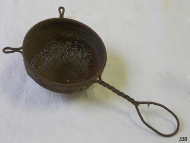
Domestic object - Strainer
Take a stroll through the average beverage aisle in your supermarket, and you might get the impression that tea has always come in small boxes with disposable tea bags. But before those easy to come by boxes, there was the rich and intriguing history of the tea strainer, a beautiful little tool that has helped our ancestors enjoy loose leaf tea for hundreds of years. Enjoying loose-leaf tea, and becoming familiar with this tool, can help spark an appreciation for your tea strainer and infuser collection, or simply inspire you to grow one. Documentation of tea tools such as the tea strainer appear in ancient history, the earliest models were likely made of bamboo, and later evolved into stainless steel, sterling silver, china, porcelain, silicon, and linen. During the Tang Dynasty in China, a small book called “Classic of Tea” was written describing tea utensils, and they were made to help Buddhist monks keep living things (such as small bugs) out of the drinking water. However, using a tea tool to keep run away tea leaves out of a cup did not become a cited use of the strainer until the 17th century when Dutch merchants made tea more readily available to those outside of the Chinese dynasty. British royals then increased the popularity of tea as their preferred beverage, and it was not long before a newfound fanaticism for tea in Great Britain spread to the American colonies, as did a growing demand for products that could separate loose tea leaves from liquid with ease and flair. Why did people use a strainer to separate out tea leaves in Great Britain and not in China? While the method of serving tea from a teapot with the tea loose in the pot was a practice used in both countries, the reason China may not have required a tool to remove leaves from their cup likely had to do with the types of tea leaves they were producing. The British owned tea plantations, in countries such as India, produced finer black tea leaves that did not require as much space to expand inside of a tea pot, where as the leaves prepared on the Chinese plantations would expand far more in the pot, and were therefore less likely to land or be bothersome inside a tea cup. This common approach to serving tea with smaller tea leaves required a solution to avoid ending up with a cup, and mouth, full of tea leaves. The obvious solution was a strainer basket. In the Victorian era, tea strainer baskets, similar to those still used in tea parlors today, were made to sit on top of the cup to capture the leaves when pouring the tea from a tea pot into the individual cups. Another solution was a tea-removing device called a mote spoon. Mote spoons act as search and rescue spoons to remove tea leaves from individual teacups. The tea would be brewed loose in the teapot, so any tea that ended up in the cup could be removed with a long handled spoon with holes in the spoon to remove rogue tea leaves and keep the steeped water in the cup. The handle also helped keep the teapot spout free of leaves and could help unclog any leaves trapped when pouring. Stainless steel tea strainers and tea infusers gained popularity in the late 19th century. Big name tea strainer producers, such as Tiffany and Gorham, could use fine silver to create quality, heavy, and sturdy strainers, for those who could afford it. There were many varieties of strainers at that time, but it was more likely that smaller designers who could not afford to mass-produce these quality strainers out of silver made them into unique shapes to attract consumers with lighter wallets. And borne was the tea strainer we are accustomed to today. Things took an unexpected turn for the tea strainer in the early 1900s when Thomas Sullivan, a tea merchant, shipped out tea samples in small silk bags. Customers did not realize that they were supposed to remove the tea from the bags, and instead boiled the tea, bag and all! The convenience of tossing out the leaves is obvious, and the popularity of tea bags is still seen today. Most premium bags of tea we are accustomed to today are frequently packaged loose for consumption, and when they are available in bags, the leaves are often crowded and do not have enough space to expand. While pyramid tea bags have become a more recent solution to this problem, due to the additional space at the top of the bag, enjoying a variety of quality tea is easier with a tea strainer in your arsenal. Besides, with the wide variety of strainers for your cup or pot in versatile materials such as mesh, silver, or a novelty silicone cartoon shape, loose tea can still reign supreme. Tea strainers sometimes do require more cleanup and measuring, but the experience and quality is always worth the effort. Besides, strainers also allow for mixing favorite tea blends together for an extra dose of delicious creativity! https://www.teamuse.com/article_170413.html The strainer provided the convenience of separating the tea leaves for disposal later.Metal strainer, bowl shaped, with mesh and twisted wire handle.Noneflagstaff hill, warrnambool, shipwrecked-coast, flagstaff-hill, flagstaff-hill-maritime-museum, maritime-museum, shipwreck-coast, flagstaff-hill-maritime-village, strainer -
 Flagstaff Hill Maritime Museum and Village
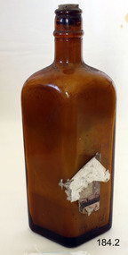
Container - Bottle, Pre 1974
Phenyle has been used for decades as a cleaner and disinfectant. It is well know for its use for cleaning outdoor toilets and easily identified by its strong odour. The brown glass bottle is immediately recognised as containing a poison. We've all seen them in a hundred different mystery movie scenes. The medicine cabinet opens and there, sitting on a shelf, is the incriminating object -- the ominous dark bottle with the skull and crossbones on the label. In off-screen reality, however, poison bottles have quite a different identity -- they are distinctive, varied, colorful -- and definitely collectible. Obviously, the one thing that sets the poison bottle apart from all other bottles is the need for prominent and immediate identification as a receptacle for toxic material, and this was achieved in a number of ways, including shape, color, embossing and labeling. Poisons were commonly found in the home for the purpose of controlling rodents and other pests, and were sold by grocers and druggists. For consumer protection, as far back as 1829, New York State made mandatory the marking of the bottles with the word "poison" in large letters. Then, in the middle of the 19th century, the American Pharmaceutical Association recommended legislation regarding identification of all poison bottles. In 1872 the American Medical Association also made recommendations -- namely that poison bottles be made of colored glass, and also have a rough surface on one side -- making them identifiable even in the dark -- and the word "poison" visible on the other (the skull and crossbones wasn't quite as ubiquitous as those movies led us to believe). However, passing these laws was not easy, and the manufacturers were essentially left to do as they wished. For collectors, the high point of poison bottle manufacturing was the period ranging roughly from the 1870s to the 1930s. At that time some, of the bottles were distinguished by particularly bright colors, such as cobalt blue (the most common) and emerald green. Others, particularly rare and collectible, had unusual -- and appropriate -- shapes, including skulls, leg bones and coffins. In order to better identify these lethal vessels by feel (not forgetting that there were many people in this period who could not read) when groping for them in the dark, they had such elaborate tactile patterns as quilted diamonds, lattices, hobnails and prominent vertical or horizontal ribbing, as well as spiky knobs and ridges. In addition, many had sharp points on top for the same precautionary purpose. Further efforts to distinguish poison bottles from others included uncommon multisided and triangular shapes, and unusual, hard-to-open tops, the predecessors of the modern child-proof openings. https://www.southcoasttoday.com/story/lifestyle/2001/08/19/poison-bottles-steeped-in-history/50352280007/The recognition and awareness of bottles containing poisonpous substances is extremely important for safety reasons.Bottle, brown glass, diamond shaped. "Bright Star" phenyle. Paper label attached, but peeling off and badly damaged. Corked with contents. Text moulded into glass, some with a border of stars. Poisonous contents, not to be taken. Registered Number 2140. Volume is 20 fluid ounces. Printed label "Bright Star". Text is moulded in the glass in raised lettering: "PHENYLE" outlined and decorated with star border. "POISONOUS", "NOT TO BE TAKEN" "V / DM / A" within oval, "REGD NO. 2140" (D and O are smaller and underlined) . Base is marked "F190".flagstaff hill, warrnambool, shipwrecked-coast, flagstaff-hill, flagstaff-hill-maritime-museum, maritime-museum, shipwreck-coast, flagstaff-hill-maritime-village, bright star, phenyl, cleaning and disinfecting chemical, poison, bottles -
 Flagstaff Hill Maritime Museum and Village
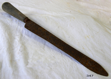
Domestic object - Knife
From the early days of our race, the knife represented one of the first and most important tools that enabled rise of our technology, military, culture, science and all other things that brought us to this point of modern civilisation. As a vital tool for survival, combat, construction and food preparation, the knife quickly became the most basic tool from which all others were born. In those ancient times, 500,000 years ago, sharpened stones started slowly evolving, becoming more and more like their modern counterpart. Before the time when fire enabled the melting of the various metals, and forging them into modern knives, their stone counterparts received several visual upgrades. Double bladed knives were most popular, and their wooden or stone hilts were decorated with animal skins and feathers. Those knives represented a great deal of pride for the warriors and elders who owned them, and that tradition continued to be practised with the arrival of the Bronze Age. The appearance of metallurgy brought the ability to create knives from softer types of metal. Even though knives from bronze did not provide durability over longer periods of time [easily dulled, and susceptible to corrosion), their sharpness and slim designed proved to be superior to any stone knife tool. As the centuries went on, iron and then steel became commonplace across the entire world. Knives created from those materials were much more durable and easier to maintain their sharpness after prolonged use. During medieval times in Europe, steel metallurgy managed to evolve knives from small single or double-bladed edges to larger sizes - swords, spears and axes. Even with all those advancements, the use of knives as an eating utensil continued to be used in some small circles. Even as early as the 15th century, wealthy circles of people started carrying personal knives, intended for double use - both eating and defending against threats. During those times the host were not obliged to provide their guest with any kind of eating utensil in addition to plates, so wealthy males used their eating knives for cutting their own meals, and the meals of nearby female guests. Slim double-bladed knives were good for cutting and piercing foods. As the use of forks became widespread in the whole of Europe by the late 17th century, most people used this kind of small knife on a regular basis (a combination of two knives, one for stabilising and other for cutting the meal). http://www.eatingutensils.net/history-of-cutlery/knife-history/The knife is one of the most important items that has enabled the development of civilisation over thousands of years.Carving knife with wooden handle and rusted slender metal blade.None.flagstaff hill, warrnambool, shipwrecked-coast, flagstaff-hill, flagstaff-hill-maritime-museum, maritime-museum, shipwreck-coast, flagstaff-hill-maritime-village, knife, kitchen equipment, dining -
 Federation University Historical Collection
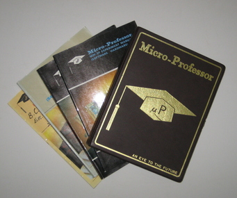
Computer, Mutlitech Industrial Corporation, Micro-Professor MPF-IP and manuals, 1983 (estimated)
The Micro-Professor I Plus (MPF-IP) was a low cost, versatile microcomputer system featuring sophisticated software and hardware capabilities. (MPF-IP) boasted a display panel with the ability to display 20 characters using 16-segment fonts. All 64 standard ASCII characters could be displayed. The operation of the MPF-IP was controlled by an 8k monitor program which resides in the Read Only Memory (ROM). The monitor, aided by 4k Random Access Memory (RAM), enabled the user to enter a comprehensive set of single keystroke commands, making it easier for the user to use the CPU, memory and I/0 devices. This allowed the user to concentrate of microprocessor software development and application design. The system allowed printing at 48 lines per minute, and the ability to permanently record the commands, data, programs, status and other messaged. Each character printed by the printer is in a 5 by 7 dot matrix. Although the prime purpose of the programming was for machine language object code formed as hexadecimal numbers, the Micro-Professor has an embedded Tiny Basic interpreter for which formation of some of the alpha characters using a standard 7 segment display was ingenious. The program memory consisted of non volatile 2 kilobytes electrically programmable ROM whilst the Random Access Memory came with 2 kilobytes of static RAM but could be upgraded to 4 kilobytes by insertion of another chip. The entire memory space of 64 kilobytes was accessible by way of the terminals on the left hand side of the board. Engineering and Science students from the Ballarat School of Mines and the Ballarat College of Advanced Education used a class set (as they were relatively inexpensive at approx. $100 each) during the mid to late 1980s. Student were encouraged to borrow the Micro-Professors in order to assist in learning how to use them. Only one was ever not returned on time. When pressed to return the device the student confessed that his dog had chewed the plastic case. This is still in our collection complete with bite marks! The Micro-Professor used a Zilog Z80 microprocessor. This was the most powerful of the 8 bit microprocessors at the time. Zilog was derived from the Intel 8080 microprocessor. The Z80 had 158 instructions of which the Intel 78 instructions were a subset. The Intel processor continued on through development in the IBM computers as 8086, 80286, 80386, 80486 and later the pentiums. Zilog lost most of its market share when it developed the 16 bit Z8000 microprocessor. Although the microprocessor was excellent, the lack of peripherals caused users to abandon Zilog products. A brown and gold plastic box containing a microcomputer for use in classrooms. Four manuals are titled 'Micro-Professor MPF-IP user's Manual', 'MPF-I Experiment Manual (Software/Hardware)', Micro-professor MPF-IP experiment Manual (Software/Hardware)' and Micro-Professor MPF-I Monitor Program Source Listing.microcomputer, micro computer, micro professor, electronics -
 Flagstaff Hill Maritime Museum and Village
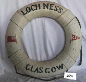
Equipment - Lifebuoy, Loch Ness, 1869-1909
This lifebuoy bears the name of the ship, its origin, the shipping company and the red ensign. These details mean that the lifebuoy was part of the lifesaving equipment on the sailing ship the Loch Ness, part of the Glasgow Shipping Company’s Loch Line (G.S.C. on the red pennant) and a British-registered ship (the red flag with the Union Jack on it). Lifebuoys were part of the emergency lifesaving equipment carried on vessels in the late 19th and early 20th century. The ring was made of strips of cork wood joined together to make the ring shape then covered in canvas and sealed usually with white paint. Four evenly spaced canvas reinforcing bands would be added for strength and for a place to thread a rope or line. A lifebuoy, or life-preserver, is used as a buoyancy device often thrown to an endangered or distressed person in the water to keep them afloat while they receive help. It is usually connected by a rope to a person in a safe area such a nearby vessel or on shore. Lifebuoys is a made from a buoyant materials such as cork or foam and ae usually covered with canvas for protection and to make it easy to grip. The first use of life saving devices in recent centuries was by the Nordic people, who used light weight wood or cork blocks to keep afloat. Cork lifebuoys were used from the late 19th to early 20th century. Kapok fibre was then used as a filling for buoys but wasn’t entirely successful. Light weight balsa wood was used as a filler after WW1. In 1928 Peter Markus invented and patented the first inflatable life-preserver. By WW2 foam was combined with Kapok. Laws were passed over time that has required aeroplanes and water going-vessels to carry life-preservers on board. The ship LOCH NESS 1869-1922 … The ship Loch Ness, of Glasgow, was the same ship what William Carmichael sailed on to Australia when he laid the commemoration stone on behalf of his sister Eva and himself, dedicated to their parents, brothers and sisters. The family members lost their lives on June 1, 1878, when their ship, the Loch Ard, was wrecked at Mutton Bird Island in south west Victoria. Eva Carmichael was one of the two survivors from that shipwreck, the other 52 tragically lost their lives. The ship Loch Ness was a three-masted sailing ship built in 1869 for the Loch Line owned by the Glasgow Shipping Company. The line transported cargo and passengers from Glasgow, Scotland, to Australian ports. The Loch Ness was sold in 1908 to Stevedore & Shipping Co, Sydney for use as a coal hulk. In 1914 the Australian Government took over the ship for naval defence purposeless. In 1926 the ship was sunk during gunfire practice by HMAS Melbourne, near Fremantle, Western Australia. The lifebuoy is an example of equipment carried on vessels in the late 19th and early 20th century to help preserve life. There were many lives lost in Australia’s colonial period, particularly along the coast of South West Victoria. The lifebuoy is significant for its connection to the ship Loch Ness on which William Carmichael, brother of Eva Carmichael, travelled to lay a memorial to their parents and all of their other siblings who lost their lives in the Loch Ard disaster of 1878 near Peterborough, Victoria. Lifebuoy, round, cork filling inside canvas cover, painted white, with rope attached. Lifebuoy has printed name of vessel Loch Ness, Glasgow. Symbols of red flag with white initials G S Co. There is also a red ensign."LOCH NESS", "GLASGOW" "G S Co"flagstaff hill, warrnambool, shipwrecked-coast, flagstaff-hill, flagstaff-hill-maritime-museum, maritime-museum, shipwreck-coast, flagstaff-hill-maritime-village, loch ness, loch ard, william carmichael, eva carmichael, lifebuoy, glasgow sailing ship, loch ness of glasgow, life rings, safety ring, life-saving buoy, ring buoy, life preserver, personal floating device, floatation device, safety equipment, g s c, glasgow shipping company -
 Flagstaff Hill Maritime Museum and Village
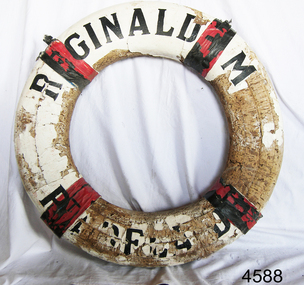
Equipment - Lifebuoy, John Murch, 1922
Lifebuoy is from the ketch Reginald M, built in Port Adelaide by John Murch in 1922. Lifebuoys were part of the emergency lifesaving equipment carried on vessels in the late 19th and early 20th century. The ring was made of strips of cork wood joined together to make the ring shape then covered in canvas and sealed usually with white paint. Four evenly spaced canvas reinforcing bands would be added for strength and for a place to thread a rope or line. A lifebuoy, or life-preserver, is used as a buoyancy device often thrown to an endangered or distressed person in the water to keep them afloat while they receive help. It is usually connected by a rope to a person in a safe area such a nearby vessel or on shore. Lifebuoys is a made from a buoyant materials such as cork or foam and ae usually covered with canvas for protection and to make it easy to grip. The first use of life saving devices in recent centuries was by the Nordic people, who used light weight wood or cork blocks to keep afloat. Cork lifebuoys were used from the late 19th to early 20th century. Kapok fibre was then used as a filling for buoys but wasn’t entirely successful. Light weight balsa wood was used as a filler after WW1. In 1928 Peter Markus invented and patented the first inflatable life-preserver. By WW2 foam was combined with Kapok. Laws were passed over time that has required aeroplanes and water going-vessels to carry life-preservers on board. The Reginald M 1922- The two-masted coastal trading ketch Reginald M was built by John (Jack) Murch in Port Adelaide, South Australia, in 1922 and it was launched there in Largs Bay in the same year. It is thought that the keel was hewn from two telegraph poles - its owner was a regular visitor to salvage yards. Its cargo at times included Guano, Barley, Wool, Horses, Cattle, Timber, Explosives, Potatoes, Shell Grit and Gypsum. At one time the vessel was used as a customs boat, renamed 'HMC No. 3, Pt Adelaide'. In 1969 she was used by a mining and railway company as a barge to carry explosives. In 1972 the vessel was renamed 'T.S. Macquarie' and planned to be used for sea cadet training.; this did not eventuate. It was sold again and went to Melbourne to be used for pleasure sailing, and again sold for use as a ferry. Late in 1975 Flagstaff Hill purchased the vessel to be used as an exhibit at the Maritime Village where many visitors enjoyed being able to board and explore a real ship with a long history. Sadly, in late 2016, the decision was made to 'decommission' the vessel due to the continuing high cost of maintenance and the risk to public safety. Many of the components of the vessel are held as part of Flagstaff Hill's collection.The lifebuoy is an example of equipment carried on vessels in the late 19th and early 20th century to help preserve life. There were many lives lost in Australia’s colonial period, particularly along the coast of South West Victoria. The lifebuoy is significant for its connection with the Australian built, 1922 coastal trader, Reginald M. Lifebuoy, round , cork, filled, white canvas cover with four red tabs. Text is printed in black on quarters 1 and 3. This lifebuoy once belonged to the vessel 'Reginald M' , Pt Adelaide. "REGINALD M / Pt ADELAIDE".flagstaff hill, warrnambool, shipwrecked-coast, flagstaff-hill, flagstaff-hill-maritime-museum, maritime-museum, shipwreck-coast, flagstaff-hill-maritime-village, lifebuoy, lifesaving, ship equipment, reginald m, life rings, safety ring, life-saving buoy, ring buoy, life preserver, personal floating device, floatation device, safety equipment, coastal trader, john murch, reg webb -
 Melton City Libraries
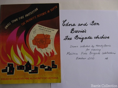
Archive, Edna and Bon Barries Fire Brigade Archives, 2010
In the 1950s with the introduction two-way HF and later VHF very high frequency radio sets. Melton Rural Fire Brigade was part of the Bacchus Marsh Group. Radio sets where located in the Melton Fire Truck, and in the house of the Barrie family at Ferris Road. This was an ideal location to observe a 360 degree view in all directions when smoke appeared on the horizon. An antenna was erected beside the house. The set OX 7 was located in the kitchen and monitored 24 hours by the family. When an electrical fire occurred at the junction of the electricity to the house there was time to radio the fire station and summons the men working in the paddocks, thus saving the house from possible destruction. With the introduction of UHF – ultra high frequency Vinten Radios the signal was clearer and static and interference lessened and radio traffic became easier to read, and reduced noise levels in the household. VL3 LY Radio Base became the Group Headquarters was established in 1967. By 1970 the Brigades were: Melton, Rockbank, Sydenham, Toolern Vale, Diggers Rest, Truganina, and Werribee. In 1974 when the family moved to First Avenue, another antenna and a small building were erected adjacent to the residence and used to house the equipment, maps. Radio traffic consisted of regular schedule times and communication with adjoining groups of brigades such as Bacchus Marsh, Mt Macedon and Little River Groups. Many of the brigade and group base radios were situated in private residences and operated primarily by fire fighters wives who held the position of Communications Officer, either registered as a brigade member or informally. Edna was never registered as an operational brigade member but operated informally as an assistant to her husband Bon. She was however a member of the Melton Fire Brigade Ladies Auxiliary from its inception in 1968, a non-operational position. Edna kept up to date with radio procedure following the 1967 handbook; preparing maps, plotting compass points and taking notes on weather forecasts from the SA Border and Western District. Daily notes were taken in anticipation of fire warnings. These log books and daily radio traffic were incidental to the regular radio schedules. Emergency turnouts noted, burning off times and predicted location of smoke. In the summer fire season all TBF (total fire ban days were recorded.) In times of emergency the Barrie family assisted Bon the base radio operator to plot the position and location of fire trucks and to help clarify garbled radio traffic, keep notes and make telephone calls. These log books are held in the EE and EW Family Archive. Items selected by Wendy Barrie for viewing Melton Fire Brigade celebrationsemergency services, local identities -
 Eltham District Historical Society Inc
Photograph, Murchison Gap, Autumn Excursion, Hume and Hovell's 1824 expedition, 26 May 1996, 26/05/1996
[article by Bettina Woodburn in EDHS Newsletter No. 109, July 1996:] ON THE TRAIL OF HUME AND HOVELL - REPORT ON THE AUTUMN EXCURSION - On a green and fresh morning (Sunday 26th May 1996) the Cobb and Co coach (driven by the most obliging Peter Tampion) set off in a north easterly direction from Eltham to connect with Hume and Hovell's route on their 1824 explorations of central Victoria. The Society would follow a series of monuments erected for the 1924 centenary of the expedition from King Parrot Creek (Tuesday 7th December 1824), through Strath Creek, over Sunday Creek (Sunday 12th December 1824) at Broadford, Tullamarine, St Albans, Deer Park, through Werribee, skirting east of the You Yangs to Lara and Avalon Beach. Because their distance-measuring wheel had broken and a one degree mistake was made in calculations, the two leaders of the original group of six convict-companions arrived at Corio Bay, instead of the expected Western Port, discovered earlier by Flinders. From below Mt. Disappointment (Hume and Hovell's difficulties in "scrambling over brush and rock", "leeches in forest, as well as no water", "cutting grass 4-5 ft. high", dreadful scrub", "devil flies") we took an easier route, saw the Strath Creek memorial in ground fog and a wonderful "field of dreams", the Hume-Hovell privately owned cricket ground with its white picket boundary fence. Now, after a steep climb, in sunshine under gums we stretched and viewed magnificent rolling hills and fog-filled valleys - not "smoke from Aborigines' bush fires". After morning tea at Broadford we followed the Sunday Creek valley beside the Hume Freeway, passed the Wallan Wallan Rest Area (more appropriately Hume and Hovell Rest Area) to tum right at Beveridge. In Gellibrand Hill Park, near the headwaters of the Moonee Ponds Creek, we experienced the landscape the first European settlers saw - huge river red gums and rolling pastures. The gardens and sheltered courtyard of the 1840s, timber, brought from .....[?] prefabricated Woodlands Homestead, provided a pleasant lunch stop. We enjoyed a private tour, panoramic views over Melbourne and surroundings and the excitement of arriving and departing aircraft. Our next river crossing was at Werribee, "in a vast treeless plain", then we drove on by-ways no coach had previously travelled, to find "an immense sheet of water" salty Corio Bay, off-course to the west. In late afternoon of a super, calm, late autumn day we headed homewards. Back at Eltham we were rather surprised to find that we had travelled a total of 347 km. Thanks again to Russell Yeoman for his research and organization. What a wonderful day! Three colour photographsactivities, murchison gap, murchison valley -
 Eltham District Historical Society Inc
Photograph, Hume and Hovell Monument, Broadford, Autumn Excursion, Hume and Hovell's 1824 expedition, 26 May 1996, 26/05/1996
[article by Bettina Woodburn in EDHS Newsletter No. 109, July 1996:] ON THE TRAIL OF HUME AND HOVELL - REPORT ON THE AUTUMN EXCURSION - On a green and fresh morning (Sunday 26th May 1996) the Cobb and Co coach (driven by the most obliging Peter Tampion) set off in a north easterly direction from Eltham to connect with Hume and Hovell's route on their 1824 explorations of central Victoria. The Society would follow a series of monuments erected for the 1924 centenary of the expedition from King Parrot Creek (Tuesday 7th December 1824), through Strath Creek, over Sunday Creek (Sunday 12th December 1824) at Broadford, Tullamarine, St Albans, Deer Park, through Werribee, skirting east of the You Yangs to Lara and Avalon Beach. Because their distance-measuring wheel had broken and a one degree mistake was made in calculations, the two leaders of the original group of six convict-companions arrived at Corio Bay, instead of the expected Western Port, discovered earlier by Flinders. From below Mt. Disappointment (Hume and Hovell's difficulties in "scrambling over brush and rock", "leeches in forest, as well as no water", "cutting grass 4-5 ft. high", dreadful scrub", "devil flies") we took an easier route, saw the Strath Creek memorial in ground fog and a wonderful "field of dreams", the Hume-Hovell privately owned cricket ground with its white picket boundary fence. Now, after a steep climb, in sunshine under gums we stretched and viewed magnificent rolling hills and fog-filled valleys - not "smoke from Aborigines' bush fires". After morning tea at Broadford we followed the Sunday Creek valley beside the Hume Freeway, passed the Wallan Wallan Rest Area (more appropriately Hume and Hovell Rest Area) to tum right at Beveridge. In Gellibrand Hill Park, near the headwaters of the Moonee Ponds Creek, we experienced the landscape the first European settlers saw - huge river red gums and rolling pastures. The gardens and sheltered courtyard of the 1840s, timber, brought from .....[?] prefabricated Woodlands Homestead, provided a pleasant lunch stop. We enjoyed a private tour, panoramic views over Melbourne and surroundings and the excitement of arriving and departing aircraft. Our next river crossing was at Werribee, "in a vast treeless plain", then we drove on by-ways no coach had previously travelled, to find "an immense sheet of water" salty Corio Bay, off-course to the west. In late afternoon of a super, calm, late autumn day we headed homewards. Back at Eltham we were rather surprised to find that we had travelled a total of 347 km. Thanks again to Russell Yeoman for his research and organization. What a wonderful day! Colour photographactivities, broadford, hume and hovell, monument -
 Eltham District Historical Society Inc
Photograph, Hume and Hovell Monument, Autumn Excursion, Hume and Hovell's 1824 expedition, 26 May 1996, 26/05/1996
[article by Bettina Woodburn in EDHS Newsletter No. 109, July 1996:] ON THE TRAIL OF HUME AND HOVELL - REPORT ON THE AUTUMN EXCURSION - On a green and fresh morning (Sunday 26th May 1996) the Cobb and Co coach (driven by the most obliging Peter Tampion) set off in a north easterly direction from Eltham to connect with Hume and Hovell's route on their 1824 explorations of central Victoria. The Society would follow a series of monuments erected for the 1924 centenary of the expedition from King Parrot Creek (Tuesday 7th December 1824), through Strath Creek, over Sunday Creek (Sunday 12th December 1824) at Broadford, Tullamarine, St Albans, Deer Park, through Werribee, skirting east of the You Yangs to Lara and Avalon Beach. Because their distance-measuring wheel had broken and a one degree mistake was made in calculations, the two leaders of the original group of six convict-companions arrived at Corio Bay, instead of the expected Western Port, discovered earlier by Flinders. From below Mt. Disappointment (Hume and Hovell's difficulties in "scrambling over brush and rock", "leeches in forest, as well as no water", "cutting grass 4-5 ft. high", dreadful scrub", "devil flies") we took an easier route, saw the Strath Creek memorial in ground fog and a wonderful "field of dreams", the Hume-Hovell privately owned cricket ground with its white picket boundary fence. Now, after a steep climb, in sunshine under gums we stretched and viewed magnificent rolling hills and fog-filled valleys - not "smoke from Aborigines' bush fires". After morning tea at Broadford we followed the Sunday Creek valley beside the Hume Freeway, passed the Wallan Wallan Rest Area (more appropriately Hume and Hovell Rest Area) to tum right at Beveridge. In Gellibrand Hill Park, near the headwaters of the Moonee Ponds Creek, we experienced the landscape the first European settlers saw - huge river red gums and rolling pastures. The gardens and sheltered courtyard of the 1840s, timber, brought from .....[?] prefabricated Woodlands Homestead, provided a pleasant lunch stop. We enjoyed a private tour, panoramic views over Melbourne and surroundings and the excitement of arriving and departing aircraft. Our next river crossing was at Werribee, "in a vast treeless plain", then we drove on by-ways no coach had previously travelled, to find "an immense sheet of water" salty Corio Bay, off-course to the west. In late afternoon of a super, calm, late autumn day we headed homewards. Back at Eltham we were rather surprised to find that we had travelled a total of 347 km. Thanks again to Russell Yeoman for his research and organization. What a wonderful day! Two colour photographsactivities, hume and hovell, monument -
 Eltham District Historical Society Inc
Photograph, Hume and Hovell Monument, Broadford, Autumn Excursion, Hume and Hovell's 1824 expedition, 26 May 1996, 26/05/1996
[article by Bettina Woodburn in EDHS Newsletter No. 109, July 1996:] ON THE TRAIL OF HUME AND HOVELL - REPORT ON THE AUTUMN EXCURSION - On a green and fresh morning (Sunday 26th May 1996) the Cobb and Co coach (driven by the most obliging Peter Tampion) set off in a north easterly direction from Eltham to connect with Hume and Hovell's route on their 1824 explorations of central Victoria. The Society would follow a series of monuments erected for the 1924 centenary of the expedition from King Parrot Creek (Tuesday 7th December 1824), through Strath Creek, over Sunday Creek (Sunday 12th December 1824) at Broadford, Tullamarine, St Albans, Deer Park, through Werribee, skirting east of the You Yangs to Lara and Avalon Beach. Because their distance-measuring wheel had broken and a one degree mistake was made in calculations, the two leaders of the original group of six convict-companions arrived at Corio Bay, instead of the expected Western Port, discovered earlier by Flinders. From below Mt. Disappointment (Hume and Hovell's difficulties in "scrambling over brush and rock", "leeches in forest, as well as no water", "cutting grass 4-5 ft. high", dreadful scrub", "devil flies") we took an easier route, saw the Strath Creek memorial in ground fog and a wonderful "field of dreams", the Hume-Hovell privately owned cricket ground with its white picket boundary fence. Now, after a steep climb, in sunshine under gums we stretched and viewed magnificent rolling hills and fog-filled valleys - not "smoke from Aborigines' bush fires". After morning tea at Broadford we followed the Sunday Creek valley beside the Hume Freeway, passed the Wallan Wallan Rest Area (more appropriately Hume and Hovell Rest Area) to tum right at Beveridge. In Gellibrand Hill Park, near the headwaters of the Moonee Ponds Creek, we experienced the landscape the first European settlers saw - huge river red gums and rolling pastures. The gardens and sheltered courtyard of the 1840s, timber, brought from .....[?] prefabricated Woodlands Homestead, provided a pleasant lunch stop. We enjoyed a private tour, panoramic views over Melbourne and surroundings and the excitement of arriving and departing aircraft. Our next river crossing was at Werribee, "in a vast treeless plain", then we drove on by-ways no coach had previously travelled, to find "an immense sheet of water" salty Corio Bay, off-course to the west. In late afternoon of a super, calm, late autumn day we headed homewards. Back at Eltham we were rather surprised to find that we had travelled a total of 347 km. Thanks again to Russell Yeoman for his research and organization. What a wonderful day! Colour photographactivities, broadford, hume and hovell, monument -
 Eltham District Historical Society Inc
Photograph, Strath Creek, Autumn Excursion, Hume and Hovell's 1824 expedition, 26 May 1996, 26/05/1996
[article by Bettina Woodburn in EDHS Newsletter No. 109, July 1996:] ON THE TRAIL OF HUME AND HOVELL - REPORT ON THE AUTUMN EXCURSION - On a green and fresh morning (Sunday 26th May 1996) the Cobb and Co coach (driven by the most obliging Peter Tampion) set off in a north easterly direction from Eltham to connect with Hume and Hovell's route on their 1824 explorations of central Victoria. The Society would follow a series of monuments erected for the 1924 centenary of the expedition from King Parrot Creek (Tuesday 7th December 1824), through Strath Creek, over Sunday Creek (Sunday 12th December 1824) at Broadford, Tullamarine, St Albans, Deer Park, through Werribee, skirting east of the You Yangs to Lara and Avalon Beach. Because their distance-measuring wheel had broken and a one degree mistake was made in calculations, the two leaders of the original group of six convict-companions arrived at Corio Bay, instead of the expected Western Port, discovered earlier by Flinders. From below Mt. Disappointment (Hume and Hovell's difficulties in "scrambling over brush and rock", "leeches in forest, as well as no water", "cutting grass 4-5 ft. high", dreadful scrub", "devil flies") we took an easier route, saw the Strath Creek memorial in ground fog and a wonderful "field of dreams", the Hume-Hovell privately owned cricket ground with its white picket boundary fence. Now, after a steep climb, in sunshine under gums we stretched and viewed magnificent rolling hills and fog-filled valleys - not "smoke from Aborigines' bush fires". After morning tea at Broadford we followed the Sunday Creek valley beside the Hume Freeway, passed the Wallan Wallan Rest Area (more appropriately Hume and Hovell Rest Area) to tum right at Beveridge. In Gellibrand Hill Park, near the headwaters of the Moonee Ponds Creek, we experienced the landscape the first European settlers saw - huge river red gums and rolling pastures. The gardens and sheltered courtyard of the 1840s, timber, brought from .....[?] prefabricated Woodlands Homestead, provided a pleasant lunch stop. We enjoyed a private tour, panoramic views over Melbourne and surroundings and the excitement of arriving and departing aircraft. Our next river crossing was at Werribee, "in a vast treeless plain", then we drove on by-ways no coach had previously travelled, to find "an immense sheet of water" salty Corio Bay, off-course to the west. In late afternoon of a super, calm, late autumn day we headed homewards. Back at Eltham we were rather surprised to find that we had travelled a total of 347 km. Thanks again to Russell Yeoman for his research and organization. What a wonderful day! Colour photographactivities, monument, hume and hovell, murchison valley, strath creek -
 Eltham District Historical Society Inc
Photograph, Murchison Gap viewed from Strath Creek, Autumn Excursion, Hume and Hovell's 1824 expedition, 26 May 1996, 26/05/1996
[article by Bettina Woodburn in EDHS Newsletter No. 109, July 1996:] ON THE TRAIL OF HUME AND HOVELL - REPORT ON THE AUTUMN EXCURSION - On a green and fresh morning (Sunday 26th May 1996) the Cobb and Co coach (driven by the most obliging Peter Tampion) set off in a north easterly direction from Eltham to connect with Hume and Hovell's route on their 1824 explorations of central Victoria. The Society would follow a series of monuments erected for the 1924 centenary of the expedition from King Parrot Creek (Tuesday 7th December 1824), through Strath Creek, over Sunday Creek (Sunday 12th December 1824) at Broadford, Tullamarine, St Albans, Deer Park, through Werribee, skirting east of the You Yangs to Lara and Avalon Beach. Because their distance-measuring wheel had broken and a one degree mistake was made in calculations, the two leaders of the original group of six convict-companions arrived at Corio Bay, instead of the expected Western Port, discovered earlier by Flinders. From below Mt. Disappointment (Hume and Hovell's difficulties in "scrambling over brush and rock", "leeches in forest, as well as no water", "cutting grass 4-5 ft. high", dreadful scrub", "devil flies") we took an easier route, saw the Strath Creek memorial in ground fog and a wonderful "field of dreams", the Hume-Hovell privately owned cricket ground with its white picket boundary fence. Now, after a steep climb, in sunshine under gums we stretched and viewed magnificent rolling hills and fog-filled valleys - not "smoke from Aborigines' bush fires". After morning tea at Broadford we followed the Sunday Creek valley beside the Hume Freeway, passed the Wallan Wallan Rest Area (more appropriately Hume and Hovell Rest Area) to tum right at Beveridge. In Gellibrand Hill Park, near the headwaters of the Moonee Ponds Creek, we experienced the landscape the first European settlers saw - huge river red gums and rolling pastures. The gardens and sheltered courtyard of the 1840s, timber, brought from .....[?] prefabricated Woodlands Homestead, provided a pleasant lunch stop. We enjoyed a private tour, panoramic views over Melbourne and surroundings and the excitement of arriving and departing aircraft. Our next river crossing was at Werribee, "in a vast treeless plain", then we drove on by-ways no coach had previously travelled, to find "an immense sheet of water" salty Corio Bay, off-course to the west. In late afternoon of a super, calm, late autumn day we headed homewards. Back at Eltham we were rather surprised to find that we had travelled a total of 347 km. Thanks again to Russell Yeoman for his research and organization. What a wonderful day! Colour photographactivities, hume and hovell, murchison valley, murchison gap, strath creek -
 Eltham District Historical Society Inc
Photograph, Autumn Excursion, Hume and Hovell's 1824 expedition, 26 May 1996, 26/05/1996
[article by Bettina Woodburn in EDHS Newsletter No. 109, July 1996:] ON THE TRAIL OF HUME AND HOVELL - REPORT ON THE AUTUMN EXCURSION - On a green and fresh morning (Sunday 26th May 1996) the Cobb and Co coach (driven by the most obliging Peter Tampion) set off in a north easterly direction from Eltham to connect with Hume and Hovell's route on their 1824 explorations of central Victoria. The Society would follow a series of monuments erected for the 1924 centenary of the expedition from King Parrot Creek (Tuesday 7th December 1824), through Strath Creek, over Sunday Creek (Sunday 12th December 1824) at Broadford, Tullamarine, St Albans, Deer Park, through Werribee, skirting east of the You Yangs to Lara and Avalon Beach. Because their distance-measuring wheel had broken and a one degree mistake was made in calculations, the two leaders of the original group of six convict-companions arrived at Corio Bay, instead of the expected Western Port, discovered earlier by Flinders. From below Mt. Disappointment (Hume and Hovell's difficulties in "scrambling over brush and rock", "leeches in forest, as well as no water", "cutting grass 4-5 ft. high", dreadful scrub", "devil flies") we took an easier route, saw the Strath Creek memorial in ground fog and a wonderful "field of dreams", the Hume-Hovell privately owned cricket ground with its white picket boundary fence. Now, after a steep climb, in sunshine under gums we stretched and viewed magnificent rolling hills and fog-filled valleys - not "smoke from Aborigines' bush fires". After morning tea at Broadford we followed the Sunday Creek valley beside the Hume Freeway, passed the Wallan Wallan Rest Area (more appropriately Hume and Hovell Rest Area) to tum right at Beveridge. In Gellibrand Hill Park, near the headwaters of the Moonee Ponds Creek, we experienced the landscape the first European settlers saw - huge river red gums and rolling pastures. The gardens and sheltered courtyard of the 1840s, timber, brought from .....[?] prefabricated Woodlands Homestead, provided a pleasant lunch stop. We enjoyed a private tour, panoramic views over Melbourne and surroundings and the excitement of arriving and departing aircraft. Our next river crossing was at Werribee, "in a vast treeless plain", then we drove on by-ways no coach had previously travelled, to find "an immense sheet of water" salty Corio Bay, off-course to the west. In late afternoon of a super, calm, late autumn day we headed homewards. Back at Eltham we were rather surprised to find that we had travelled a total of 347 km. Thanks again to Russell Yeoman for his research and organization. What a wonderful day! Colour photographactivities, hume and hovell -
 Eltham District Historical Society Inc
Photograph, Sign to Hume and Hovell Cricket Ground, at Allandale Road, Strath Creek, Autumn Excursion, Hume and Hovell's 1824 expedition, 26 May 1996, 26/05/1996
[article by Bettina Woodburn in EDHS Newsletter No. 109, July 1996:] ON THE TRAIL OF HUME AND HOVELL - REPORT ON THE AUTUMN EXCURSION - On a green and fresh morning (Sunday 26th May 1996) the Cobb and Co coach (driven by the most obliging Peter Tampion) set off in a north easterly direction from Eltham to connect with Hume and Hovell's route on their 1824 explorations of central Victoria. The Society would follow a series of monuments erected for the 1924 centenary of the expedition from King Parrot Creek (Tuesday 7th December 1824), through Strath Creek, over Sunday Creek (Sunday 12th December 1824) at Broadford, Tullamarine, St Albans, Deer Park, through Werribee, skirting east of the You Yangs to Lara and Avalon Beach. Because their distance-measuring wheel had broken and a one degree mistake was made in calculations, the two leaders of the original group of six convict-companions arrived at Corio Bay, instead of the expected Western Port, discovered earlier by Flinders. From below Mt. Disappointment (Hume and Hovell's difficulties in "scrambling over brush and rock", "leeches in forest, as well as no water", "cutting grass 4-5 ft. high", dreadful scrub", "devil flies") we took an easier route, saw the Strath Creek memorial in ground fog and a wonderful "field of dreams", the Hume-Hovell privately owned cricket ground with its white picket boundary fence. Now, after a steep climb, in sunshine under gums we stretched and viewed magnificent rolling hills and fog-filled valleys - not "smoke from Aborigines' bush fires". After morning tea at Broadford we followed the Sunday Creek valley beside the Hume Freeway, passed the Wallan Wallan Rest Area (more appropriately Hume and Hovell Rest Area) to tum right at Beveridge. In Gellibrand Hill Park, near the headwaters of the Moonee Ponds Creek, we experienced the landscape the first European settlers saw - huge river red gums and rolling pastures. The gardens and sheltered courtyard of the 1840s, timber, brought from .....[?] prefabricated Woodlands Homestead, provided a pleasant lunch stop. We enjoyed a private tour, panoramic views over Melbourne and surroundings and the excitement of arriving and departing aircraft. Our next river crossing was at Werribee, "in a vast treeless plain", then we drove on by-ways no coach had previously travelled, to find "an immense sheet of water" salty Corio Bay, off-course to the west. In late afternoon of a super, calm, late autumn day we headed homewards. Back at Eltham we were rather surprised to find that we had travelled a total of 347 km. Thanks again to Russell Yeoman for his research and organization. What a wonderful day! Colour photographactivities, hume and hovell, allandale road, strath creek -
 Eltham District Historical Society Inc
Photograph, Autumn Excursion, Hume and Hovell's 1824 expedition, 26 May 1996, 26/05/1996
[article by Bettina Woodburn in EDHS Newsletter No. 109, July 1996:] ON THE TRAIL OF HUME AND HOVELL - REPORT ON THE AUTUMN EXCURSION - On a green and fresh morning (Sunday 26th May 1996) the Cobb and Co coach (driven by the most obliging Peter Tampion) set off in a north easterly direction from Eltham to connect with Hume and Hovell's route on their 1824 explorations of central Victoria. The Society would follow a series of monuments erected for the 1924 centenary of the expedition from King Parrot Creek (Tuesday 7th December 1824), through Strath Creek, over Sunday Creek (Sunday 12th December 1824) at Broadford, Tullamarine, St Albans, Deer Park, through Werribee, skirting east of the You Yangs to Lara and Avalon Beach. Because their distance-measuring wheel had broken and a one degree mistake was made in calculations, the two leaders of the original group of six convict-companions arrived at Corio Bay, instead of the expected Western Port, discovered earlier by Flinders. From below Mt. Disappointment (Hume and Hovell's difficulties in "scrambling over brush and rock", "leeches in forest, as well as no water", "cutting grass 4-5 ft. high", dreadful scrub", "devil flies") we took an easier route, saw the Strath Creek memorial in ground fog and a wonderful "field of dreams", the Hume-Hovell privately owned cricket ground with its white picket boundary fence. Now, after a steep climb, in sunshine under gums we stretched and viewed magnificent rolling hills and fog-filled valleys - not "smoke from Aborigines' bush fires". After morning tea at Broadford we followed the Sunday Creek valley beside the Hume Freeway, passed the Wallan Wallan Rest Area (more appropriately Hume and Hovell Rest Area) to tum right at Beveridge. In Gellibrand Hill Park, near the headwaters of the Moonee Ponds Creek, we experienced the landscape the first European settlers saw - huge river red gums and rolling pastures. The gardens and sheltered courtyard of the 1840s, timber, brought from .....[?] prefabricated Woodlands Homestead, provided a pleasant lunch stop. We enjoyed a private tour, panoramic views over Melbourne and surroundings and the excitement of arriving and departing aircraft. Our next river crossing was at Werribee, "in a vast treeless plain", then we drove on by-ways no coach had previously travelled, to find "an immense sheet of water" salty Corio Bay, off-course to the west. In late afternoon of a super, calm, late autumn day we headed homewards. Back at Eltham we were rather surprised to find that we had travelled a total of 347 km. Thanks again to Russell Yeoman for his research and organization. What a wonderful day! Colour photographactivities, hume and hovell -
 Eltham District Historical Society Inc
Photograph, Autumn Excursion, Hume and Hovell's 1824 expedition, 26 May 1996, 26/05/1996
[article by Bettina Woodburn in EDHS Newsletter No. 109, July 1996:] ON THE TRAIL OF HUME AND HOVELL - REPORT ON THE AUTUMN EXCURSION - On a green and fresh morning (Sunday 26th May 1996) the Cobb and Co coach (driven by the most obliging Peter Tampion) set off in a north easterly direction from Eltham to connect with Hume and Hovell's route on their 1824 explorations of central Victoria. The Society would follow a series of monuments erected for the 1924 centenary of the expedition from King Parrot Creek (Tuesday 7th December 1824), through Strath Creek, over Sunday Creek (Sunday 12th December 1824) at Broadford, Tullamarine, St Albans, Deer Park, through Werribee, skirting east of the You Yangs to Lara and Avalon Beach. Because their distance-measuring wheel had broken and a one degree mistake was made in calculations, the two leaders of the original group of six convict-companions arrived at Corio Bay, instead of the expected Western Port, discovered earlier by Flinders. From below Mt. Disappointment (Hume and Hovell's difficulties in "scrambling over brush and rock", "leeches in forest, as well as no water", "cutting grass 4-5 ft. high", dreadful scrub", "devil flies") we took an easier route, saw the Strath Creek memorial in ground fog and a wonderful "field of dreams", the Hume-Hovell privately owned cricket ground with its white picket boundary fence. Now, after a steep climb, in sunshine under gums we stretched and viewed magnificent rolling hills and fog-filled valleys - not "smoke from Aborigines' bush fires". After morning tea at Broadford we followed the Sunday Creek valley beside the Hume Freeway, passed the Wallan Wallan Rest Area (more appropriately Hume and Hovell Rest Area) to tum right at Beveridge. In Gellibrand Hill Park, near the headwaters of the Moonee Ponds Creek, we experienced the landscape the first European settlers saw - huge river red gums and rolling pastures. The gardens and sheltered courtyard of the 1840s, timber, brought from .....[?] prefabricated Woodlands Homestead, provided a pleasant lunch stop. We enjoyed a private tour, panoramic views over Melbourne and surroundings and the excitement of arriving and departing aircraft. Our next river crossing was at Werribee, "in a vast treeless plain", then we drove on by-ways no coach had previously travelled, to find "an immense sheet of water" salty Corio Bay, off-course to the west. In late afternoon of a super, calm, late autumn day we headed homewards. Back at Eltham we were rather surprised to find that we had travelled a total of 347 km. Thanks again to Russell Yeoman for his research and organization. What a wonderful day! Colour photographactivities, hume and hovell -
 Flagstaff Hill Maritime Museum and Village
Instrument - Ship Log, Early 20th Century
In times past the only way to measure a ship’s speed was to throw a wood log into the water and observe how fast it moved away from the ship. In the 16th century, the log was fastened to a rope knotted at set intervals. The log was thrown over the stern (back) of the vessel and a crew member counted the number of knots that were paid out in a set time. From this, they could estimate the vessel's speed through the water. This was known as streaming the log and is also the derivation of the knot as a measurement of nautical speed. Various manufacturers of nautical equipment had sought over the years to perfect the operation of determining a ship's speed and it wasn't until Thomas Walker and his son Ferdinand developed a mechanical system that eventually made this task became easy for marine navigators. Thomas Walker & Son were internationally renowned in the manufacturing of ship logs the founding father, Thomas Walker (1805–1871), an engineer in Birmingham, patented his mechanical log in 1878 which was a recording instrument that attached to a rail at the stern of a vessel connected by a long cord with a rotor which was towed behind the ship. The instrument dial then recorded the distance travelled. Thomas Walker first went into business to manufacture stoves at 58 Oxford Street Birmingham. Walker’s self-feeding stove was widely lauded at the Paris Exhibition of 1855, winning a prize medal and kickstarting the first of many notable innovations for the Walker family's manufacturing business. However, it wasn’t until working on an earlier ship’s log model invented by his Uncle that Thomas Walker became interested in the further development of this device, used to ascertain a ship’s speed. Walker continued to improve on the common log for the company of Massey & Sons and these improvements were deemed revolutionary. This log became a firm favourite of the West India Association (a British-based organisation promoting ties and trade with the British Caribbean), being the most common log in use for two generations. It took until 1861 for Thomas Walker and his son, Thomas Ferdinand Walker (1831-1921) to patent the first Walker log of many. Together, with the introduction of the A1 Harpoon Log two years later, they established the Walker Log Business as a force to be reckoned with. By his passing in 1871, Thomas Walker Snr had not only founded a family business with considerable staying power but also instilled a tradition of public service. Having sat as a representative on the Birmingham Town Council for 15 years and played an active role in public works, he was soon given the nickname of ‘Blue Brick Walker’. Much like his father, Thomas Ferdinand Walker changed the face of the maritime industry. His patent of 1897, the ‘Cherub’ log, was a notable departure from the past providing a far more accurate reading and replacing the majority of logs of the age. They were the first to produce an electric log (Trident) and the Walker factory was one of the first to introduce the 48-hour work week for employees.The ship log was invented and made by a significant marine instrument maker and innovator of machinery. It demonstrates the huge leap taken to improve navigational accuracy at sea with an instrument that was in use for decades.Ships Log, Walker Trident electric motor, in wooden box with instructions inside box. The motor dial with electric cord is still inside box.Inscription "Admiralty patent number 3332" and "Walker Trident Electric Ship Log (Mark III), 15-25 volt". On top of lid, hand written, is "G TAYLOR"flagstaff hill, warrnambool, shipwrecked-coast, flagstaff-hill, flagstaff-hill-maritime-museum, maritime-museum, shipwreck-coast, flagstaff-hill-maritime-village, ships log, thomas walker & son, electric ships log, marine navigation, thomas ferdinand walker, ship log -
 Chiltern Athenaeum Trust
Painting - Oil painting on gumleaf by Alfred William Eustace, circa 1851 to 1907
This gum leaf painting is one of a pair displayed on foil in the same frame. It is typical of many paintings by the self-taught Australian artist Alfred William Eustace (1820-1907). A.W. Eustace, a well-known Australian artist, was born in Berkshire, England, where he was an assistant gamekeeper to the Earl of Craven at Ashdown Park. He migrated to Australia with his wife and children in 1851 and camped on the Ullina and Eldorado Runs on the Black Dog Creek at Chiltern, which was in excess of 50,000 acres of grazing land. A.W. Eustace was employed as a shepherd by Jason Withers and while tending his flocks in the solitude of the bush, Eustace turned his attention to painting and music to while away the long and weary hours. He endeavoured to capture the spirit of the bush painting on board, canvas or tin plate, but as these materials were not always readily available he then started painting on large round eucalyptus leaves from the White and Red Box trees that grew around about him. About 1856 he painted a small picture of the famous Woolshed goldrush and during the next few years became well known in North-East Victoria. John Sadlier, a police officer stationed at Beechworth said that Eustace painted 'some really exquisite scenes. He was of an easy-going dreamy temperament, a student of nature only, despising the works of men. Unfortunately his drawings were on eucalyptus leaves, the largest and roundest he could find and not on canvas, and no doubt have all perished long ago.' In 1876 the Melbourne Age newspaper reported, 'Eustace’s celebrated paintings on gum leaves are again attracting attention,…Mr Eustace is an elegant artist…he seems without effort to catch the colour and spirit of Australian scenery…' In 1864 A.W. Eustace held an Art Union in Albury, and again in 1884 in Ballarat. He exhibited at the Victorian Academy of Arts in 1877 and also held an exhibition of gum leaf paintings at Stevens Gallery, Melbourne in 1893. By 1896 he was receiving orders from heads of states in Europe, with his works acknowledged by Queen Victoria, Emperor Frederick of Germany and the Czar of Russia, as well as the Governors of New South Wales and Victoria. His paintings reflected his ability to paint the sky in his realistic style which is still noted by art critics of the day. A.W. Eustace was also a skillful taxidermist. The collection of birds and animals that can be seen at the Beechworth Museum are examples of his taxidermy skill. When not doing his work, painting or taxidermy, he regularly contributed letters and verse to the Chiltern newspaper, The Federal Standard. A book of verse in his hand writing was presented to The Athenaeum Trust by the Boadle family. In the 1870’s he became interested in spiritualism often being involved in lively debate at lectures and séances. Alfred William Eustace died in 1907 and is buried in the Chiltern New Cemetery with his wife Sarah and one of his daughters, Elizabeth.An oil painting on gum leaf by the well-known Australian artist Alfred William Eustace. He was a self-taught artist during the 19th and early 20th century and a prominent resident of Chiltern. Oil painting on gum leaf by Alfred William Eustace. A scene of a log cabin on Black Dog Creek Road, Chiltern, with Skeleton Hill in the background. The canvas is a juvenile Red Box (Eucalyptus polyanthemos) leaf. It is one of a pair of Eustace gum leaf paintings mounted on gold foil, under glass in a brown frame. Inscription on back. Labels on back: Rehoused by The Centre for Cultural Materials/ Conservation, University of Melbourne "Oil on Gum Leaf"/ by Alfred William Eustace/ Donor:- Cam & Connie Boadle/ Wales U.K. Crescent/ MUSEUM/ GRADE/ 24 OCT 1998/ CONSERVATION BOARD ALBURY/ PICTURE FRAMERS/ Shop 15 & 16/ AMP Lane,/ Albury, 2640/ Ph: 02 6021 7088black dog creek, chiltern, alfred eustace, skeleton hill, gum leaf, painting, eustace