Showing 1088 items matching "geology"
-
 Bendigo Historical Society Inc.
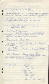
Document - PETER ELLIS COLLECTION: NOTES WRITTEN BY PETER ELLIS
Some brief research? Notes written by Peter Ellis from the years 1881 to 1899. Mentioned is the Bendigo School of Mines Science Society and some of its meetings and the number of people who attended. Also mentioned are: The animal of Australia by Dr. MacGillivray; a paper on graptolite by Mr T L Hall, M.A., Director of Castlemaine School of Mines; Annual Report June 30 1888, Spiders, ? & Marsupials (MacGillivray/Rev Williams; Nancarrow - Slides & Cross Courses - Geological quartz of Goldfield; 27/1/1887 Meetings held during the year - some were well attended, some were not; On the 31 May the President (MacGillivray) spoke at some length on the Requirement of a Local Museum; Annual report 1900; Mining Society formed 1899 and Scientific Conversation lecturettes on Chemistry & Electricity.bendigo, history, early bendigo, peter ellis collection, the a-- of australia, dr macgillivray, t l hall ma, castlemaine school of mines, bendigo school of mines science society, rev williams, nancarrow, sandhurst district, requirements of a local museum, melb public library -
 Bendigo Historical Society Inc.
Map - HUSTLER'S ROYAL RESERVE NO 2 MINE - PLAN OF THE HUSTLER'S ROYAL RESERVE NO 2 MINE
Plan of the Hustler's Royal Reserve No 2 Mine Bulletin No 33, Plate No V. Plan shows the Hustler's Royal Reserve No 2 (Main Shaft), Hustler's Royal Reserve No 2 (Park Shaft.), the Royal Hustler's, the Imperial Hustler's and the Extended Hustler's Freehold on the Hustler's Line of Reefs. Also mentioned is the Lightning Hill Line of Reefs. Map shows some of the levels, approximate boundary of lease and the boundary of Lease No 8892 and 8897. There are also street names and the locations of jail, lagoons, Post Office, Rosalind Park and the State School, High School and Continuation School. Geological Survey of Victoria emblem. H. Herman Director, W. Dickson, Secretary of Mines and The Hon. J. Drysdale Brown MLC, Minister of Mines. Signed by zh Whitdan, Underground Survey Office, Bendigo, September 1913.mining, parish map, hustler's royal reserve no 2 mine, royal hustler's, imperial hustler's, extended hustler's freehold, geological survey of victoria, h herman, w dickson, the hon j drysdale brown, h whitdan, hustler's line of reefs, lightning hill line of reefs -
 Federation University Historical Collection
Booklet, Berry Anderson & Co, The Ballarat School of Mines, Calendar and Annual Report 1895, 1895
The Ballarat School of Mines Calendar and Annual Report 1895. Associateship of The School, Calendar for 1895, Certificates Granted by the Council 1894, Certificates Granted by the Education Department 1893, Comparative Statement of Receipts and Expenditure, Departmental Expenditure, Examiners, Examination Papers, Examination Fees, Fees, Honorary Correspondents, Life Governors, Meteorological Observations, Number of Students attended The School of Mines, Obituary, Office Bearers, Practical Treatment of Ores, Professors and Lecturers, Report of the Professor of Mineralogy and Geology and Curator of the Museum, Report of the Superintendent of Laboratories, Report of the Lecturer on Engineering and Surveying, Report of the Lecturer on Mathematics, Report of the Instructor in Engineering and Machine Construction and Design, Report of the Lecturer on Electrical Engineering, Report of the Lecturer on Geometrical Model and Perspective Drawing, Report of the Lecturer on Botany, Report of the Lecturer on Palaeontology, Materia Medica and Mining Ambulance, Scale of Charges for Assays and Analyses, Statement of Receipts and Expenditure for year 1894, Statistics - Student attending Lectures, Subscriptions and Donations, Syllabus of Lecture Courses, Time TableThe Ballarat School of Mines Calendar and Annual Report, 1895. Pale brown soft cover, 90 pages. ballarat school of mines, annual report, andrew anderson j.p. - president, f. j. martell - vice president, r. denham pinnock - vice president, the hon. sir w. j. clarke - trustee, the hon. john warrington rogers - trustee, the right reverend samuel thornton - trustee, andrew anderson - trustee, james millhinch - trustee, james oddie - trustee, the hon. henry cuthbert - honorary solicitor, r. g. middleton - honorary treasurer, charles kent - auditor, andrew berry - registrar, professor alf. mica smith - chemistry, metallurgy, natural philosophy, professor krause - geology, mineralogy, principles of mining, professor g. j. dawbarn - mine and land surveying, mining mechanics, hydraulics, civil engineering, applied mechanics, j. rowe - practical mining, j. a. dawson - electrical engineering, d. walker - chemistry and natural philosophy, w. e. bennett - mathematics, henry j. hall - freehand and perspective drawing, a. e. c. kerr - mechanical drawing (machine construction and design), george p. day - botany, e. gutheil - paleontology, zoology, materia medica, rivett henry bland - obituary, george gant scott - obituary, fiddian, bennett, r. allan, dawbarn, rosales, krause, joseph bryant, matthews, j. robinson, andrew robertson, john lynch, jonathan robinson, a.e.c. kerr, alfred mica smith, frederick mccoy, j. cosmo newberry, blackett, elelry, arnot, robert allan, bickett, kent, martin, mitchell, ferdinand von mueller, rivett henry bland, thomas bath, john rowe, museum, andrew anderson, george day, subscriptions and donations, examination papers -
 The Beechworth Burke Museum
Geological specimen - Actionlite and Pyrite
Actinolite is usually found in metamorphic rocks, such as contact aureoles surrounding cooled intrusive igneous rocks. It also occurs as a product of the metamorphism of magnesium-rich limestones. Pyrite is usually found with other sulfides or oxides in quartz veins, sedimentary rock, and metamorphic rock, as well coal beds, and as a replacement mineral in fossils. Actinolite is an amphibole silicate mineral. It is named after the Greek word "aktinos" meaning “ray” in allusion to the mineral's fibrous nature. Fibrous actinolite is a type of asbestos and was once mined along Jones Creek at Gundagai, New South Wales. Pyrite or "Fool's Gold" is the most common sulfide mineral. It is named after the Greek "pyr" meaning "fire" because it can be used to create sparks needed for a fire if struck against metal or a hard surface. Due to its gold colour, pyrite can be mistaken for gold and often forms alongside it, causing small amounts of gold to be present in rocks containing pyrite. Most importantly, pyrite is an ore of gold. Pyrite is sometimes used as a gemstone but is not great for jewellery as it easily tarnishes. In some fossils of ammonites – shelled cephalopods that died ~66 million years ago – pyrite also replaces the shell. This specimen is part of a larger collection of geological and mineral specimens collected from around Australia (and some parts of the world) and donated to the Burke Museum between 1868-1880. A large percentage of these specimens were collected in Victoria as part of the Geological Survey of Victoria that begun in 1852 (in response to the Gold Rush) to study and map the geology of Victoria. Collecting geological specimens was an important part of mapping and understanding the scientific makeup of the earth. Many of these specimens were sent to research and collecting organisations across Australia, including the Burke Museum, to educate and encourage further study. A small-medium-sized solid specimen with the minerals actinolite (dark green fibrous) and pyrite (brassy) with shades of brown, black/grey, and white. Actinolite is an amphibole mineral in the tremolite-actinolite series of calcium, magnesium, and iron silicates. Pyrite is an iron disulfide mineral.geological specimen, geology, geology collection, burke museum, beechworth, indigo shire, geological, mineralogy, pyrite, actinolite, victoria, sewyln, alfred selwyn -
 The Beechworth Burke Museum
Geological specimen - Amazonite, unknown
Amazonite is classed as a Tectosilicate and is part of the Feldspar group of minerals. Amazonite forms in a triclinic crystal structure and its chemical formula is K(AlSi3O8). In appearance, Amazonite can range from shades of green to green blue to blue, and often with white streaks or veining. The greenish colour is believed to come from the small amount of lead contained in its composition. Amazonite is named after the Amazon River due to its colour and similarities to another rock found along the riverbanks, although Amazonite is not actually found at or near the Amazon. Although less commonly used in jewellery today, Amazonite has been mined and used by humans for thousands of years and Amazonite jewellery from at least 2000BCE have been discovered in North Africa. Amazonite is found in many locations around the world including Brazil, Peru, Ethiopia, Canada, Russia, Mozambique, Myanmar, Pakistan, China, Madagascar, and the United States of America. This specimen most probably comes from the U.S.A., Amazonite is found in several US states particularly in Colorado, Virginia, Pennsylvania. This specimen is of both scientific and historic significance as a striking blue green example of Amazonite mined prior to 1868 in the United States of America, most likely from Colorado, Virginia, or Pennsylvania. These three states are all locations of significant Amazonite deposits. This specimen is part of a larger collection of geological and mineral specimens collected from around Australia (and some parts of the world) and donated to the Burke Museum between 1868-1880. A large percentage of these specimens were collected in Victoria as part of the Geological Survey of Victoria that begun in 1852 (in response to the Gold Rush) to study and map the geology of Victoria. Collecting geological specimens was an important part of mapping and understanding the scientific makeup of the earth. Many of these specimens were sent to research and collecting organisations across Australia, including the Burke Museum, to educate and encourage further study.A palm-sized Feldspar mineral specimen from the Tectosilicate class in shades of blue-green with white veining.Existing label: green/blue Feldspar / "amazonite" / possibly USA geological specimen, geology, geology collection, burke museum, beechworth, tectosilicate, amazonite, feldspar, triclinic crystal structure, amazonite usa, amazonite colorado, amazonite virginia, amazonite pennsylvania -
Federation University Historical Collection
Booklet, Victorian Minerals Education Centre, c1990
Ballarat University College (Now Federation University) was designated by the State Government as the centre for Mining Engineering Education in Victoria. The Victorian Minerals Education Centre was estabioshed in 1990 with a grant from teh Victorian Education Foundation to provide Victoria with a centre of excellence to support development of mineral resources.Promotional brochure for the Victorian Minerals Education Centrevictorian minerals education centre, vmec, richard croggon, pete dahlhaus, steve carey, stafford mcknight, w.r.h. ramsay, brian sunter, c. swaminathan, s. zang, mining engineering, geology, metallurgy -
 The Beechworth Burke Museum
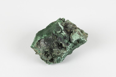
Geological specimen - Malachite, Unknown
Malachite is a copper carbonate hydroxide mineral. It has a chemical composition of Cu2(CO3)(OH)2. It often forms within limestone where a subsurface chemical environment favourable for the formation of carbonate minerals can occur. It is a substance that can be found in many different parts of the world including: Australia, USA, Russia and the Democratic Republic of Congo. Malachite has historically been used to produce copper, with mining of the mineral dating back over a period of four thousand years. Due to its beautiful green colourations, it is also commonly used for aesthetic purposes such as in the production of sculptures and jewellery. This particular specimen was collected from the town of Burra, South Australia as part of a geological survey undertaken during the nineteenth century. The locality (located on Ngadjuri Country) has a long history of mining, particularly in copper mining, as the area is rich in copper deposits. The first significant discovery of this was made in Burra (Burra Burra Mine) in 1845 and, at the time, the mine was the largest and richest of its kind in the world, producing nearly five percent of the total world copper output. This specimen is significant as it is considered to be a rare gemstone, as many of the original deposits for the stones are significantly depleted, leaving behind very few sources. This specimen is part of a larger collection of geological and mineral specimens collected from around Australia (and some parts of the world) and donated to the Burke Museum between 1868-1880. A large percentage of these specimens were collected in Victoria as part of the Geological Survey of Victoria that begun in 1852 (in response to the Gold Rush) to study and map the geology of Victoria. Collecting geological specimens was an important part of mapping and understanding the scientific makeup of the earth. Many of these specimens were sent to research and collecting organisations across Australia, including the Burke Museum, to educate and encourage further study.A solid palm-sized copper carbonate hydroxide mineral with patterns of green colourations Existing Label: MALACHITE / Locality: Burra / S. Aust. Other Label: Confirmed / as Malachite / C. Willman / 15/4/1 / + Bill Birch burke museum, beechworth, geological, geological specimen, malachite, gemstone, green gemstone, burra, burra burra mine, burra south australia, carbonate mineral, copper, copper mining, copper mining burra, carbonate hydroxide mineral, copper carbonate, malachite mining, malachite burra, monster mine -
 Eltham District Historical Society Inc
Photograph, Liz Pidgeon, Heritage Excursion; East of Eltham, 6 Sep 2014, 20 May 2017
Newsletter No. 218, September 2014 September Excursion - East of Eltham Walk In Newsletter No. 197, March 2011, there was a brief history of Crown Allotment 15 Section 5 Parish of Nillumbik (CA 15) a parcel of land of a quarter of a square mile extending from Eucalyptus Road to Reynolds Road at the eastern extremity of Eltham. From the 1940s it was known as Stokes orchard. In later years it has been subdivided for residential purposes but leaving significant areas as power line and water supply reserves and bushland reserves that are habitat for the threatened For our excursion on 6th September we intend to walk through CA 15 to a bushland reserve east of Reynolds Road. The walk will traverse the boundary between suburban Eltham and the non-urban areas to the south and east. This is a pleasant walk through residential areas and bushland. Along the way we will discuss the early and more recent history of CA 15 as well as local natural history and geology. This walk is about 3.5 km in length and will take 2 to 2.5 hours. It will start at 2pm at the corner of Eucalyptus Road, Pitt Street and Nyora Road.Born Digitaleltham east, eltham district historical society, heritage excursion, activities, nyora road, reynolds road, gum tree road reserve, diosma road, stokes orchard, eucalyptus road -
 Eltham District Historical Society Inc
Photograph, Liz Pidgeon, Heritage Excursion; East of Eltham, 6 Sep 2014, 20 May 2017
Newsletter No. 218, September 2014 September Excursion - East of Eltham Walk In Newsletter No. 197, March 2011, there was a brief history of Crown Allotment 15 Section 5 Parish of Nillumbik (CA 15) a parcel of land of a quarter of a square mile extending from Eucalyptus Road to Reynolds Road at the eastern extremity of Eltham. From the 1940s it was known as Stokes orchard. In later years it has been subdivided for residential purposes but leaving significant areas as power line and water supply reserves and bushland reserves that are habitat for the threatened For our excursion on 6th September we intend to walk through CA 15 to a bushland reserve east of Reynolds Road. The walk will traverse the boundary between suburban Eltham and the non-urban areas to the south and east. This is a pleasant walk through residential areas and bushland. Along the way we will discuss the early and more recent history of CA 15 as well as local natural history and geology. This walk is about 3.5 km in length and will take 2 to 2.5 hours. It will start at 2pm at the corner of Eucalyptus Road, Pitt Street and Nyora Road.Born Digitaleltham east, eltham district historical society, heritage excursion, activities, nyora road, reynolds road, gum tree road reserve, diosma road, stokes orchard, eucalyptus road