Showing 681 items
matching gold mines in victoria
-
 Bendigo Historical Society Inc.
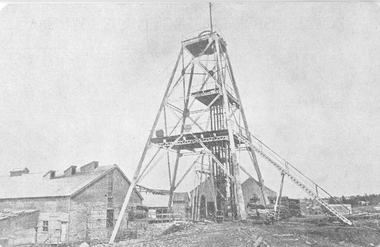
Photograph - AUSTIN COLLECTION: Central Deborah Gold Mine Lift Shaft
Central Deborah Gold Mine history: At its peak, Central Deborah Gold Mine reached a depth of 412 metres. It has 17 separate levels and 15 kilometres of drives and cross cuts (tunnels). The Central Deborah was very much a hands-on mine and the conditions that the miners worked in would be considered shocking by today's standards – being lowered underground in a cage with only two sides, often working ankle to knee deep in water, filling up to 32 ore trucks a shift by hand which were then pushed a mile or more along rails in the drives, working by carbide lamp, breathing in the fumes and rock dust and communication by bells. Geez, they were ironmen. However, at the time working conditions were considered to be among the best on the goldfields at Central Deborah, after all it was one of the only mines that had hot showers. Following Central Deborah Gold Mine's closure, the Bendigo skyline began to noticeably change. Obvious remnants of mining such as poppet heads, engine rooms, service quarters, battery houses and chimneys were steadily disappearing. After intense lobbying by the local community, the Bendigo City Council purchased the still very much intact Central Deborah Gold Mine in 1970 for a mere $6,000 to ensure that a vital link to Bendigo's historic golden past was maintained. The Bendigo Trust was then formed to oversee the operations of the Central Deborah Gold Mine, which led to the surface of the mine being opened to the public in 1971. Initially the surface was open for just 12 hours a week and as the demand for viewing a part of Bendigo's history increased, so did the opening hours. In 1974 the mine was gazetted as a Public Historical Purposes Reserve and attracted such visitors as H.R.H Prince Charles. By far the greatest shortcoming at this stage was that no one could view the underground workings, as these had become flooded. After what could only be described as a monumental effort by everyone involved, Level 2 of the mine was officially opened to the public by the Premier of Victoria, the Honourable John Cain, on 20 June 1986, which brought to fruition a long standing dream.Black and white photograph, looking from bottom of lift shaft towards the surface; light visible at top of shaft. Lift cables and safety mesh on sides of shaft. gold mining, central deborah gold mine, ray beer, mine manager -
Bendigo Historical Society Inc.
Photograph - AUSTIN COLLECTION: Central Deborah Gold Mine, Possibly 1990's
Central Deborah Gold Mine history: At its peak, Central Deborah Gold Mine reached a depth of 412 metres. It has 17 separate levels and 15 kilometres of drives and cross cuts (tunnels). The Central Deborah was very much a hands-on mine and the conditions that the miners worked in would be considered shocking by today's standards – being lowered underground in a cage with only two sides, often working ankle to knee deep in water, filling up to 32 ore trucks a shift by hand which were then pushed a mile or more along rails in the drives, working by carbide lamp, breathing in the fumes and rock dust and communication by bells. Geez, they were ironmen. However, at the time working conditions were considered to be among the best on the goldfields at Central Deborah, after all it was one of the only mines that had hot showers. Following Central Deborah Gold Mine's closure, the Bendigo skyline began to noticeably change. Obvious remnants of mining such as poppet heads, engine rooms, service quarters, battery houses and chimneys were steadily disappearing. After intense lobbying by the local community, the Bendigo City Council purchased the still very much intact Central Deborah Gold Mine in 1970 for a mere $6,000 to ensure that a vital link to Bendigo's historic golden past was maintained. The Bendigo Trust was then formed to oversee the operations of the Central Deborah Gold Mine, which led to the surface of the mine being opened to the public in 1971. Initially the surface was open for just 12 hours a week and as the demand for viewing a part of Bendigo's history increased, so did the opening hours. In 1974 the mine was gazetted as a Public Historical Purposes Reserve and attracted such visitors as H.R.H Prince Charles. By far the greatest shortcoming at this stage was that no one could view the underground workings, as these had become flooded. After what could only be described as a monumental effort by everyone involved, Level 2 of the mine was officially opened to the public by the Premier of Victoria, the Honourable John Cain, on 20 June 1986, which brought to fruition a long standing dream.Black and white photograph. Two men with hard hats and lights, inspecting quartz outcrop on wall of drive at Central Deborah Gold Mine.gold mining, central deborah gold mine, ray beer, mine manager -
Bendigo Historical Society Inc.
Photograph - AUSTIN COLLECTION: Operating rock drill, Central Deborah Gold Mine, Possibly 1990's
Central Deborah Gold Mine history: At its peak, Central Deborah Gold Mine reached a depth of 412 metres. It has 17 separate levels and 15 kilometres of drives and cross cuts (tunnels). The Central Deborah was very much a hands-on mine and the conditions that the miners worked in would be considered shocking by today's standards – being lowered underground in a cage with only two sides, often working ankle to knee deep in water, filling up to 32 ore trucks a shift by hand which were then pushed a mile or more along rails in the drives, working by carbide lamp, breathing in the fumes and rock dust and communication by bells. Geez, they were ironmen. However, at the time working conditions were considered to be among the best on the goldfields at Central Deborah, after all it was one of the only mines that had hot showers. Following Central Deborah Gold Mine's closure, the Bendigo skyline began to noticeably change. Obvious remnants of mining such as poppet heads, engine rooms, service quarters, battery houses and chimneys were steadily disappearing. After intense lobbying by the local community, the Bendigo City Council purchased the still very much intact Central Deborah Gold Mine in 1970 for a mere $6,000 to ensure that a vital link to Bendigo's historic golden past was maintained. The Bendigo Trust was then formed to oversee the operations of the Central Deborah Gold Mine, which led to the surface of the mine being opened to the public in 1971. Initially the surface was open for just 12 hours a week and as the demand for viewing a part of Bendigo's history increased, so did the opening hours. In 1974 the mine was gazetted as a Public Historical Purposes Reserve and attracted such visitors as H.R.H Prince Charles. By far the greatest shortcoming at this stage was that no one could view the underground workings, as these had become flooded. After what could only be described as a monumental effort by everyone involved, Level 2 of the mine was officially opened to the public by the Premier of Victoria, the Honourable John Cain, on 20 June 1986, which brought to fruition a long standing dream.Black and white photograph. Two men with hard hats and lights standing in front of underground rock surface at Central Deborah Gold Mine. Man on left hand side of image is operating a small rock drill. Man on right hand side is observing the procedure. gold mining, central deborah gold mine, rock drill, underground -
 Bendigo Historical Society Inc.
Map - MINING PLAN ,VICTORIA HILL AREA, No date visible
... MAP Bendigo mining plan Mining Gold Mines Victoria Hill ...Map: Large scale plan of an area of the Goldfield, Northward from Barnard Street, covering the Victoria Hill area. Black printing on polycarbonate film. Transparent.map, bendigo, mining plan, mining, gold mines, victoria hill, lines of reef -
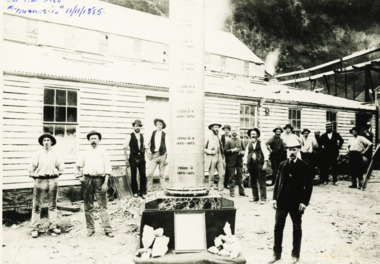 Lakes Entrance Historical Society
Photograph - Goldmining Walhalla, J Phillips, December 1885
Detailed information on back of photograph regarding gold amountsBlack and white photograph showing the exhibits to be sent to the colonial and Indian Exhibition London by the Long Tunnel Company Many men in the photograph in front of weatherboard building Mechanics Institute Walhalla VictoriaSee Walhalla Memorialmines and mining, exhibition -
Clunes Museum
Book, MAY TOWNSEND, EARLY PIONEERS IN AND AROUND CLUNES, 1989
THE STORIES OF 102 PIONEERS IN THE CLUNES, VICTORIA, AUSTRALIA DISTRICT.1 BEIGE SOFT COVER BOOKLET WITH AN DRAWING OF A MAN AND A WOMAN PUSHING A CART WITH THEIR BELONGINGS, A SIGN ON THE SIDE "GOLD MINES" ON THE BOTTOM "COME ON MISSUS GIVE 'ER A SHOVE" THE STORIES OF 102 PIONEERS 155 PAGES .2 SECOND COPY OF THE SAME PUBLICATION COVERED IN ADHESIVE CLEAR VINYL A PRINTED "WITH COMPLIMENTS SLIP" FROM HALONA SZTYNDA, ARCHIVIST, ST. PATRICKS COLLEGE BALLARAT, VICTORIA, AUSTRALIA INCLUDED WITH THIS COPY.non-fictionTHE STORIES OF 102 PIONEERS IN THE CLUNES, VICTORIA, AUSTRALIA DISTRICT early pioneers in and around clunes, may townsend -
 Bendigo Historical Society Inc.
Newspaper - NEWSPAPER COLLECTION: BENDIGO ADVERTISER VARIOUS ARTICLES
1) Bendigo the Golden Heart of Victoria 2) News from Bendigo May, 1973 3) Some Scenes of Bendigo Yesteryear 4) Cover Bendigo Advertiser Souvenir of the Shamrock Hotel 5) Saving the Shamrock - Doug McClure 6) Farewell Bendigo's Trams April, 1972 7) 100 Years of Trams 8) Gold Mine a Popular Attraction 9) Tomorrow the end (Trams) April 1972 10) Trams 1890-1903-1972/ Photo New Chum 11) Vintage Talking Trams 12) In Search of a Home for Sun Loong 13) Bendigo Dragon City 14) History Indicates that Dragons is not as Silly 15) Bendigo's Dragon is Something to be Proud of 16) Unravelling the Dragon's Mysteries 17) Reputation Precede it 18) Tourism 19) Haunted by the Ghosts of the Gold Rush 20) Bendigo Undertaking Firm Installs Complete Motor Funeral Equipment 21) Built on the Foundations of Gold 22) Photos: Bridge Street - Oakley's Establishment 23) A City Built on reefs of Fabulous Wealth 24) Bendigo Company Has High Hopes for Old Mine 25) The Central Deborah 26) Central Deborah Reaches New Depths 27) WMC Prepares the Way for Bendigo Mining Revival 28) Historical Background of Fortuna 29) Opening of TAFE College 30) 60 Protesting Nurses Greet the Premier 31) A History Written in Bricks 32) The Golden Age of Bendigo Theatre Part 1 33) The Golden Age of Bendigo Theatre Part 2 34) J.H. Curnow is Back Home 35) Fortuna Historical Background 36) Photos of Fortuna. Folder 110 now in Box 417. AV 03/11/2022bendigo, goldfields, tourism, history -
 Bendigo Historical Society Inc.
Map - HUSTLER'S REEF & HUSTLER'S REEF NO 1 MINES - LONGITUDINAL SECTION OF THE HUSTLER'S REEF & HUSTLER'S
Longitudinal Section of the Hustler's Reef & Hustler's Reef No 1 Mines on the Hustler's Line of Reef. Bulletin No 33, Plate No XX. Note - Plates 4, 8, 13, 20, 26 & 31 form a Longitudinal Section from Fortuna Hustler's to Hustler's Consols Mine. Geological Survey of Victoria emblem. Signed by H A Whitelaw, Underground Survey Office Bendigo, September 1913. Shows the two shafts with their levels and depths. Also shows geographical features and yields of gold and amalgam per ton. .mining, parish map, hustler's reef & hustler's reef no 1 mines, geographical survey of victoria, underground survey office bendigo, h a whitelaw -
 Bendigo Historical Society Inc.
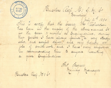
Document - HUSTLERS REEF MINE - REFERENCE FOR WM RICHARDSON
Handwritten reference for William Richardson. It mentions he has been employed as an engine driver and is very handy at smith work. Signed by Tho Tregear, Mining Manager from the Hustlers Reef No 1 G. M. Co. Dated July 4th, 1896. Blue stamp of Royal Historical Society of Victoria, Bendigo Branch in the top left corner. Also, another piece of paper mentioning William Richardson is the grandfather of Albert Richardson who wrote notes on mines.mine, gold, hustlers reef mine, william richardson, tho tregear -
 Bendigo Historical Society Inc.
Document - HERCULES AND ENERGETIC MINES - NOTES ON THE HERCULES AND ENERGETIC MINES
Four typed copies of notes on the Hercules and Energetic Mines. Notes include Location, depth of shafts, plant and machinery, Early History and Prominence. Reference: Mines Dept Special Edition Australian Mining Standard 1.6.1899, Mines Dept Booklet Bendigo Goldfield 1936, Mines Dept Annual and Quarterly Reports, Annals of Bendigo Mining Sections 1876 - 1921, A Richardson, The Bendigo Goldfield Registry J N Macartney 1.3.1871, Mines Dept Bulletin No 30 h Herman 1914, Bendigo Amalgamated Goldfields Coy Financial Reports 1920. There are three typed copies, also the original handwritten notes.mine, gold, hercules and energetic mines, notes on the hercules and energetic mines, the north energetic, the victoria pilot, plan of leases of 1870, bendigo amalgamated goldfields company, sheepshead line, central blue, big blue, mines dept special edition australian mining standard 1.6.1899, mines dept booklet bendigo goldfield 1936, annals of bendigo mining sections 1876 - 1921, a richardson -
 Bendigo Historical Society Inc.
Document - GREAT SOUTHERN MINE - CAGE ACCIDENT AT VICTORIA QUEEN NO 4 SHAFT
Handwritten account of cage accident at the Great Southern Coy's Victoria Queen No 4 Shaft in 1881. Two brothers, David and Thomas Clapperton were killed when the cage fell. The engine driver's name was Tyler. Also, a typed copy.mine, gold, great southern mine, cage accident at victoria queen no 4 shaft, david clapperton, thomas clapperton, tyler -
 Bendigo Historical Society Inc.
Postcard - GREAT EXTENDED HUSTLERS MINE - POSTCARD OF POPPET LEGS & BUILDINGS
Grey & white postcard showing poppet legs and buildings at the Great Extended Hustlers Mine. Printed on the back: 'Royal Historical Society of Victoria Bendigo Branch. Great Extended Hustlers Locality: Hustlers Hill, Nth. Bendigo Formed 1865 - Last production 1921 Depth of shaft - 3,470 feet Poppet Legs - Steel, 70 feet high Winding Engine: First motion, 8 ft. Drums. Gold Very Rich Total yield - 300,000 oz. Dividends 675,000 Poundsmine, gold, great extended hustlers mine, hustlers hill nth bendigo -
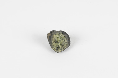
 The Beechworth Burke Museum
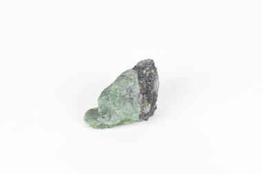
Geological specimen - Green Feldspar (orthoclase)
Feldspar, derived from the German word feldspat, is a group of minerals which is the most common mineral group found on Earth, making up more than half of the planet's crust. The major rock-forming minerals in the Feldspar group include albite, anorthite, orthoclase and microcline. (Mindat, Feldspar Group). Orthoclase is part of the Feldspar Group subgroup, Alkaline Feldspar, which are known to be poor in calcium, and mostly rich in potassium. It is further also considered to be a K Feldspar, a subgroup of Alkaline Feldspar that are Potassium-dominant with variable crystal symmetry and Al-Si ordering state. Orthoclase are most commonly Colorless to white, Greenish white, Grayish yellow, or Pale pink and transparent to translucent with slightly pearly cleavage. The mineral rates at a 6 on the Mohs Hardness Scale. (cannot be scratched with a knife, but scratches glass with difficulty). The stronger green colour of this particular specimen is distinctive to the Broken Hill region (where it was found), and due to a small amount of lead. (BB) Its qualities find it misidentified at times as as microcline variety amazonite. Broken Hill is one of the world’s richest lead-zinc-silver deposits. The huge, 300-million-tonne orebody was discovered in 1883 and the superb mineral specimens attract collectors from around the world. (Australian Museum, Minerals from Australia: Australian mining regions)While feldspar is not by any means rare, this particular specimen has qualities distinctive to the Broken Hill mining district, with these properties leading at times to the mineral's misidentification. This creates potential for further study and identification of these mineral deposits through methods such as microscopic twinning, or using the position of certain d values in XRD patterns to calculate the degree of disorder of a K-feldspar, as discussed on the Mindat website (Mindat.com, Orthoclase:About Orthoclase). This specimen is part of a larger collection of geological and mineral specimens collected from around Australia (and some parts of the world) and donated to the Burke Museum between 1868-1880. A large percentage of these specimens were collected in Victoria as part of the Geological Survey of Victoria that begun in 1852 (in response to the Gold Rush) to study and map the geology of Victoria. Collecting geological specimens was an important part of mapping and understanding the scientific makeup of the earth. Many of these specimens were sent to research and collecting organisations across Australia, including the Burke Museum, to educate and encourage further study.A solid small aluminosilicate mineral composition which is primarily pale green and blue-grey in colour with traces of beige and white throughout. Note: green plumbian orthoclase (aka green feldspar) is an indicator mineral for the Broken Hill style lead-zinc deposits.N/Abroken hill mine, geological specimen, minerology -
 The Beechworth Burke Museum
Geological specimen - Tourmaline (schorl), Unknown
Tourmaline is a group of minerals belonging to the complex borosilicate mineral class. These minerals are known for their striking and varied colours, making them prized gemstones. Tourmaline crystals can come in various shades, including pink, green, blue, brown, black, and colourless. They are often transparent or translucent. Tourmaline's chemical composition is complex, but it typically includes elements such as aluminium, iron, magnesium, sodium, lithium, and potassium. The specific arrangement of these elements in the crystal lattice gives rise to the different colours and properties of tourmaline specimens. Tourmaline specimens from Beechworth, Victoria, Australia, are a notable part of the region's mineral heritage. These tourmalines are of interest to mineral collectors and enthusiasts. While the tourmaline found in Beechworth is not as well-known as some other tourmaline varieties, it has unique characteristics and a historical context associated with the gold mining areas in Beechworth.The significance of tourmaline in Beechworth, Victoria, Australia, lies in its unique geological and historical context, contributing to both scientific and cultural aspects. The tourmaline mined in Beechworth is a rare and unique variety of tourmaline that is primarily found in the historic gold mining areas surrounding Beechworth. Its occurrence is closely linked to the geological processes that shaped the region during the Gold Rush era. The discovery of tourmaline in Beechworth adds to the rich mineral heritage of the area, which was historically known for gold mining. The specimens serve as a tangible connection to the region's mining history and contribute to preserving its geological legacy. The presence of tourmaline in Beechworth showcases the mineralogical diversity of the area. Tourmaline is known for its wide range of colours and unique properties, making it a valuable subject of study for mineralogists and geologists. Tourmaline specimens from Beechworth have educational significance, providing opportunities for research and study. They offer insights into the geological processes and mineral formation in the region, contributing to a better understanding of Earth's geological history.A hand-sized solid mineral specimen in shades of brown, green, light grey and dark greyTOURMALINE (schorl) / (Silicate of boron and aluminum) burke museum, beechworth, indigo shire, geological, geological specimen, mineralogy, tourmaline -
 The Beechworth Burke Museum
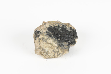
Geological specimen - Olivine with Chromian diopside (dark green), Unknown
This specimen was donated in 1868 by Alfred Selwyn. Olivine is typically found in basic and ultra-basic igneous rocks around the world, in a variety of colours including yellowish green, olive green, greenish black and reddish brown with a transparent to translucent diaphaneity. The luster of the specimen is vitreous, the luminescence non-fluorescent and when fractured the mineral is very brittle producing small, conchoidal fragments. Chromian diopside is normally found in small sizes as the larger the size of the mineral the darker the colour is, almost black rather than green. Chromium is the element that gives chromian diopside and emeralds their rich green colour. Diopside is found across the world in multiple colours however gem-quality chromian diopside is mined in Siberia, Russia and prominent within the jewellery industry as a more affordable substitute to emeralds. Chromium-bearing diopside has been located across Australia. Chromium-bearing Diopside is located across the world found in North America, parts of South America, and across Australia, Africa, Europe and Asia. Chromium-bearing Diopside is mined in Siberia, Russia and is sold as a commercial substitute for emeralds. The stone is often turned into jewellery. This item is one of many geological and mineral specimens that constitute a broader collection obtained from various regions across Australia (as well as some international locales) and generously contributed to the Burke Museum between 1868 and 1880. A significant portion of these specimens originated from Victoria and were acquired as a result of the Geological Survey of Victoria, initiated in 1852 during the Gold Rush era. The primary objective of this survey was to investigate and chart the geological characteristics of Victoria. The procurement of geological specimens played a vital role in advancing our comprehension of the Earth's scientific composition and was instrumental in supporting research and educational institutions throughout Australia, including the Burke Museum, in their efforts to foster further exploration and study. A solid mineral specimen in shades of green, grey and brownburke museum, beechworth, geological, geological specimen -
 Bendigo Historical Society Inc.
Map - HUSTLER'S ROYAL RESERVE NO 2 CO. - LONGITUDINAL SECTION OF THE HUSTLER'S ROYAL RESERVE NO 2 CO
Longitudinal Section of the Hustler's Royal Reserve No 2 Co. on the Hustler's Line of Reef Bulletin No 33, Plate No VIII. Note - Plates 4, 8, 13, 20, 26 & 31 form a Longitudinal Section from Fortuna Hustler's to Hustler's Consols Mine. Mines mentioned are the Hustler's Royal Reserve No 2 Main Shaft, Hustler's Royal Reserve No 2 Park Shaft, Royal Hustler's, Imperial Hustler's, Great Extended Hustler's Freehold and the Great Extended. Section shows depth of levels, datum lines and height of sill above sea level yield in oz. of gold. Geological Survey of Victoria emblem. H. Herman, Director, W. Dickson, Secretary for Mines and The Hon. J. Drysdale Brown MLC, Minister for Mines and signed by H S Whitelaw, Underground Survey Office Bendigo, September 1913. mining, parish map, hustler's royal reserve no 2, royal hustler's, imperial hustler's, great extended hustler's freehold, great extended, geological survey of victoria, underground survey office bendigo, h s whitelaw, h herman, w dickson, the hon j drysdale brown -
 Bendigo Historical Society Inc.
Map - UNITED HUSTLER'S & REDAN & K. K. MINES - PLAN OF THE UNITED HUSTLER'S & REDAN & K. K. MINES
Plan of the United Hustler's & Redan & K. K. Mines Bulletin No 33 Plate No XXXI. Shows depth of levels, Probable positions of reefs and natural surface with the poppet legs at the two shafts. Sill of shaft of the K. K. Mine 773.56 ft above Sea Level and sill of shaft of the United Hustler's & Redan Mine 745.62 above Sea Level. Also mentioned is the average amount of gold obtained per ton. Note on the top of page - Plates 4, 8, 13, 20, 26 & 31 form a Longitudinal Section from Fortuna Hustler's to Hustler's Consols Mine. Geological Survey of Victoria emblem and signed by H S Whitelaw, Underground Survey Office, Bendigo, September 1913. mining, parish map, united hustler's & redan & k. k. mines, geological survey of victoria, h s whitelaw, underground survey office bendigo -
 The Beechworth Burke Museum
Photograph
This image is a reproduction of an 1899 original depicting the 'Williams Good Luck Mine' on the Mopoke Reef (also called 'Morepork Gully') in the Dingle Ranges, approximately three miles from Beechworth. A large opening to a mine can be seen behind the men in the photograph, with a wheeled cart on a track leading to the men's position, where the soil and rocks have been hauled away. This photograph interestingly contains dogs alongside the miners. While dogs have been recorded as deterrents to thieves in the Victorian goldfields, these dogs appear as companions to these men. Following the discovery of gold at Beechworth in 1852, rushes quickly followed at surrounding creeks and gullies in the district. In the late nineteenth and early twentieth centuries, small syndicates of miners continued to work old or abandoned quartz reefs, often persisting without the assistance of heavy machinery to remove the large amounts of rock, in order to obtain yields at ever greater depths. The group of miners in this photograph are Mr. Roger Williams and Sons, who revived operations at the ‘Old Good Luck’ mine on the Mopoke Reef in the Dingle Range near Beechworth around 1892, working the site for more than two decades. An emigrant from Cornwall with experience in the tin mining industry, 19 year old Roger Williams senior sailed to New Zealand in 1840, then to Australia where he spent time in the Bendigo Gold Fields before settling in Beechworth in the early 1860s. Mr Williams senior worked on various mining activities in the district, including the Rocky Mountain Tunnel project. Conversant with the character of gold-bearing reefs in the area, the syndicate dug an eight hundred foot tunnel, digging down as far down as two hundred feet with little capital save their labour, to connect and provide better working access to the mass of reefs and veins in the vicinity. Progress was hampered by poor air quality charged with fumes from dynamite and large quantities of rock had to be crushed to obtain payable yields. The Victorian Goldfields are filled with ruins and remnants of the area's rich mining history, ranging from small alluvial diggings to the remains of huge mining companies. Site names often changed several times throughout the nineteenth and twentieth centuries. Some sites were abandoned and forgotten, others were worked continuously over many decades. The names of mines were often repeated at different locations throughout the Victorian Goldfields. For example, there is a Mopoke Gully heritage mine near Fryers Creek, Victoria. 'Mopoke' is a common onomatopoeic name for Morepork and Australian Boobook owls.This image has historical, social and research significance for patterns of emigration during of the Victorian Gold Rush, and the historical, social and environmental impacts of mining at Beechworth at the turn of the nineteenth and twentieth centuries. As gold became scarce and government support and large company investment waned, poor hard-working miners laboured intensively to make a living through periods of high unemployment. This image can be compared and studied alongside other historical mining photographs and objects in the Burke Museum Collection. It has potential to improve our understanding of miners working conditions and the shifting character of mining in the Beechworth district.Sepia coloured rectangular photograph printed on gloss photographic paper mounted on card. Obverse: Williams/ Good/ Luck Reverse: A02498/ 1997. 2498/ Good Luck/ Mine/ 1899/ Mopoke. burke museum, beechworth museum, beechworth, gold fields, gold rush, victorian gold rush, gold ming history, colonial australia, australian gold rushes, mining technology, beechworth historic district, indigo gold trail, migration, indigo shire, good luck gold mine, victorian goldfields, mining syndicates, gold fever, quartz-mining, small-scale mining, old good luck mine, mopoke gully, quartz reefs beechworth -
 The Beechworth Burke Museum
Photograph
This image is a reproduction of an 1899 original depicting the 'Williams Good Luck Mine' on the Mopoke Reef (also called 'Morepork Gully') in the Dingle Ranges, approximately three miles from Beechworth. The foreground of the image is littered with piles of smashed rock and detritus, known as ‘mullock’, beside a reinforced mine shaft, a vertical access passageway allowing miners to enter the mine and haul ore out using lifting technology such as a poppet heads, whims or windlasses. A group of miners and a dog appear close to an open-sided miner’s hut. Following the discovery of gold at Beechworth in 1852, rushes quickly followed at surrounding creeks and gullies in the district. In the late nineteenth and early twentieth centuries, small syndicates of miners continued to work old or abandoned quartz reefs, often persisting without the assistance of heavy machinery to remove the large amounts of rock, in order to obtain yields at ever greater depths. The group of miners in this photograph are Mr. Roger Williams and Sons, who revived operations at the ‘Old Good Luck’ mine on the Mopoke Reef in the Dingle Range near Beechworth around 1892, working the site for more than two decades. An emigrant from Cornwall with experience in the tin mining industry, 19 year old Roger Williams senior sailed to New Zealand in 1840, then to Australia where he spent time in the Bendigo Gold Fields before settling in Beechworth in the early 1860s. Mr Williams senior worked on various mining activities in the district, including the Rocky Mountain Tunnel project. Conversant with the character of gold-bearing reefs in the area, the syndicate dug an eight hundred foot tunnel, digging down as far down as two hundred feet with little capital save their labour, to connect and provide better working access to the mass of reefs and veins in the vicinity. Progress was hampered by poor air quality charged with fumes from dynamite and large quantities of rock had to be crushed to obtain payable yields. The Victorian Goldfields are filled with ruins and remnants of the area's rich mining history, ranging from small alluvial diggings to the remains of huge mining companies. Site names often changed several times throughout the nineteenth and twentieth centuries. Some sites were abandoned and forgotten, others were worked continuously over many decades. The names of mines were often repeated at different locations throughout the Victorian Goldfields. For example, there is a Mopoke Gully heritage mine near Fryers Creek, Victoria. 'Mopoke' is a common onomatopoeic name for Morepork and Australian Boobook owls.This image has historical, social and research significance for patterns of emigration during of the Victorian Gold Rush, and the historical, social and environmental impacts of mining at Beechworth at the turn of the nineteenth and twentieth centuries. As gold became scarce and government support and large company investment waned, poor hard-working miners laboured intensively to make a living through periods of high unemployment. This image can be compared and studied alongside other historical mining photographs and objects in the Burke Museum Collection. It has potential to improve our understanding of miners working conditions and the shifting character of mining in the Beechworth district.Sepia coloured rectangular photograph printed on gloss photographic paper mounted on card.Obverse: Reverse: A02497/ 1997.2497/ 'Good/ Luck/ Mine'/ Morepork/ Gully/ Mrs Joyce/ Bright/ Tunnel/ 800 ft/ 1899. burke museum, beechworth museum, beechworth, gold fields, gold rush, victorian gold rush, gold ming history, colonial australia, australian gold rushes, mining technology, beechworth historic district, indigo gold trail, migration, indigo shire, good luck gold mine, victorian goldfields, mining syndicates, gold fever, quartz-mining, small-scale mining, old good luck mine, mopoke gully, quartz reefs beechworth -
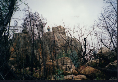 Wooragee Landcare Group
Photograph, circa April 2003
This photograph was taken in the Mount Pilot Chiltern National Park. This park is located near Chiltern in Victoria. It's most notable landmarks include Mt Pilot and Woolshed Falls. It also has many mines from the Gold Rush in the late 1800s. It is home to much flora and fauna, including the tiger quoll. The tiger quoll, also known as the spotted-tail quoll, is a marsupial that gives in the Mount Pilot Chiltern National Park. It is also main land Australia's largest carnivorous marsupial. It can weigh up too four kilograms and looks similar to either a possum or a spotted cat. It has red and brown fur with distinct spots. The tiger quoll is found along the Great Dividing Range, which includes Victoria, New South Wales and also near the border of Queensland. It lives in forests, rainforests and coastal heathlands and woodlands. In 2004 a team of volunteers from the Wooragee Landcare group as well as some of the Department of Sustainability and Environment staff set out to find the tiger quoll following the 2003 bushfires. Since the bushfires, concern had arisen for it because it hadn't been seen since the bushfires. They attempted to find traces of the quoll through finding and identifying their droppings as well as DNA testing. This photograph was taken during this search. This photograph represents the work that goes into protecting a important species like the tiger quoll. The tiger quoll is a significant species because it is main land Australia's largest carnivorous marsupial. As a result of this, there has been much work done to preserve and protect it. This photograph was taken when the Wooragee Landcare group went to ensure the survival of this species, highlighting how the tiger quoll is being protected. This photograph also demonstrates the impacts of the 2003 bushfires in the Mount Pilot Chiltern National Park. This is seen through the burnt trees featured in the picture. Landscape coloured photograph printed on gloss paperReverse: WAN NA 0ANA0N0 NNN 0 1636 / [PRINTED] (No.7) / 921quoll, mount pilot chiltern national park, national park, 2003 bushfires, search, endangered, beechworth, wooragee landcare group, wooragee landcare, wooragee, possum, australia, victoria, department of sustainability and environment, photograph, 2004, spotted-tailed quoll, great dividing range, spots, fur, forests, rainforests, woodlands, coastal heathlands, spotted quoll, spotted quoll habitat -
Bendigo Historical Society Inc.
Photograph - Valentine's Snapshots of Bendigo x 8
Valentine's Snapshots of Victoria - Bendigo x 8. Hand colored photographs. Scenes include Deborah Gold Mines looking towards Bendigo; Mitchell Street; Civic Buildings; Lake Weeroona; Conservatory Gardens; The Mall; Rosalind Park; Conservatory Gardens. Has a small fawn colored envelope into which the cards fit. Possibly 1950's. Printed in Britain. Published by the Valentines Publishing Co; Melbourne. These cards are numbered 11, 12, 13, 14, 15, 16, 17, 18. bendigo, weeroona, rosalind park, the mall, mitchell street, deborah mines